Meatyorologist
-
Posts
9473 -
Joined
-
Last visited
-
Days Won
13
2 Followers

About Meatyorologist

Recent Profile Visitors


Meatyorologist's Achievements
")


-

July 2024 In The Pacific Northwest
Meatyorologist replied to snow_wizard's topic in West of the Rockies
Pull the timing ahead by one day and it's on my day off! -
July 2024 In The Pacific Northwest
Meatyorologist replied to snow_wizard's topic in West of the Rockies
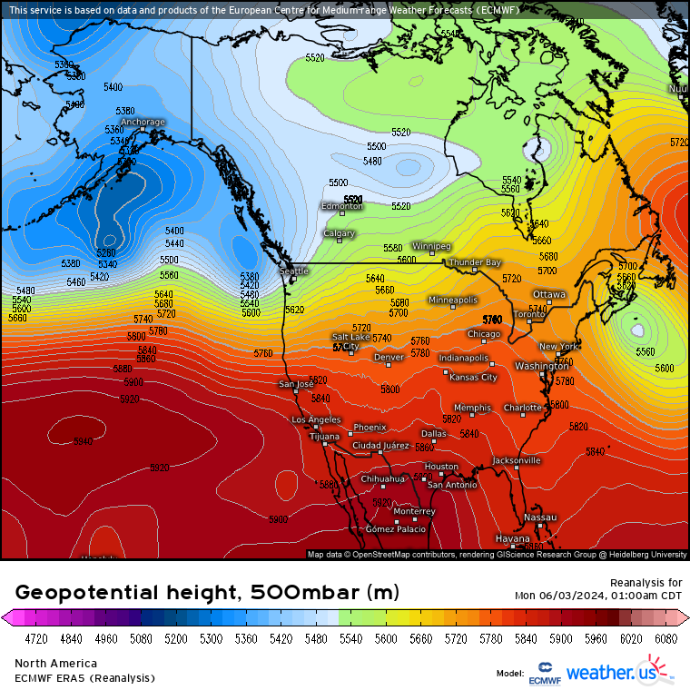
Monday's setup is almost identical to June 2nd earlier this year, adjusting for late July climo in the NH. Weak impulse from the NNW picking up anomalous moisture from the NPac and dumping it over us about as efficiently as possible.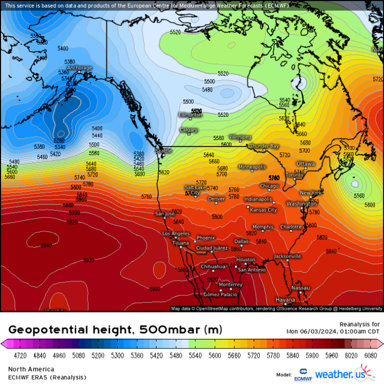

-
July 2024 In The Pacific Northwest
Meatyorologist replied to snow_wizard's topic in West of the Rockies
An inch for my house would be incredible -
July 2024 In The Pacific Northwest
Meatyorologist replied to snow_wizard's topic in West of the Rockies
A PERFECT BALANCE to the barely noticeable heat of this month. I think we're due now for eight consecutive 100F burgers south of 50°N and four more decades of ridging -
July 2024 In The Pacific Northwest
Meatyorologist replied to snow_wizard's topic in West of the Rockies
Got down to 52F at KSEA. Impressive. -
1870s Historic Winter Highlights
Meatyorologist replied to BLI snowman's topic in West of the Rockies
This is a great thread. Does anyone have data on the 1850s or earlier? -
1870s Historic Winter Highlights
Meatyorologist replied to BLI snowman's topic in West of the Rockies
Heaven -
July 2024 In The Pacific Northwest
Meatyorologist replied to snow_wizard's topic in West of the Rockies
It'll be dependent on exact timing for sure. Looks like a fickle setup with a 15-20F range of potential highs in the puget sound area. -
July 2024 In The Pacific Northwest
Meatyorologist replied to snow_wizard's topic in West of the Rockies
GFS is more generous. Mid 70s by 18z. It can underrepresent midlevel cloudcover though and it's hard to bet against the Euro. -
July 2024 In The Pacific Northwest
Meatyorologist replied to snow_wizard's topic in West of the Rockies
Sunday also looks like a marine layer day. -
July 2024 In The Pacific Northwest
Meatyorologist replied to snow_wizard's topic in West of the Rockies
Monday will probably have a late morning high since the main frontal rain bands arrive in the afternoon. Might push 80F if cloudcover is thin; that airmass ahead of it is not cold. Tuesday is a much different story. Moist residual low level marine airmass in place while weak ridging builds overhead. Similar situation to the other day, might not hit 70F or even see the sun. -
July 2024 In The Pacific Northwest
Meatyorologist replied to snow_wizard's topic in West of the Rockies
With the colder air aloft it was bound to happen -
July 2024 In The Pacific Northwest
Meatyorologist replied to snow_wizard's topic in West of the Rockies
I can't imagine any thunderstorm pattern we get through early August will bring much dry lightning. We have an unusually warm and moist north Pacific to advect from, and we'll almost certainly avoid a large ridge in that timeframe, so no pressure-cooked dry desert airmass to tap into either. They'd probably be #whet and falling through PWAT's in excess of 1". -
July 2024 In The Pacific Northwest
Meatyorologist replied to snow_wizard's topic in West of the Rockies
What we're looking at D4+ is an amorphous blob of warm, near-saturated air, amidst impulses of varying strength and timing saturating it at will. The question is when, and how much rain do we get? Not a very typical summer weather pattern in recent years. The CMC is quite generous, with multiple impulses; maybe even some deformation and lightning on the 2nd. -
July 2024 In The Pacific Northwest
Meatyorologist replied to snow_wizard's topic in West of the Rockies
@Phil And once again, it doesn't matter. Officially speaking it's a +0.3F day in the books, check the preliminary July summary for yourself. The auto generated climate reports aren't official.