


catnip
-
Posts
239 -
Joined
-
Last visited
Posts posted by catnip
-
-
-
Stay safe if you are in Burlington this evening, sad news.
-
 3
3
-
-
Watching CNN also. I wish i could experience something like that again. Only time I remember a snowmaggedon here was Dec 2008.
2008 and also 1996 for me.
-
Who needs the Comedy Network tonight when you can just watch CNN.
-
I'm getting drunk on CNN's storm coverage.
Where's the blizzard mobile?
-
what plant does a poutin grow on?
You can only grow them in Quebec.
-
1
-
-
I thought that was a spray of white spring flowers.
It is the spray from his "Sprouting Bulb".
He's been pretty excited lately.
-
1
-
-
40F and raining here this morning. I have to take my mother to the doctors today. She slipped on the ice last week and shattered her wrist. Winter is evil. I have never heard of anyone being injured by sprouting Bulbs.
Some Sprouting Bulbs can get rather large, and if care is not taken with said sprouting bulb, injuries can and will occur.
-
12Z Canadian look nice right before Christmas...
http://img.meteocentre.com/models/gemglb_amer_12/GZ_D5_PN_240_0000.gif
Hopefully you are right in your call for something decent between Christmas and New Years!
-
Off the chart.
-
-
-
PDX tracking down some late Nov and early Dec rainfall records from 1996. Hmmmmm, 1996!
That's an analog I can get behind!
-
D**n Canadians!
-
1
-
-
Nice...
http://old.ecmwf.int/products/forecasts/d/getchart/catalog/products/forecasts/medium/deterministic/msl_uv850_z500!Geopotential%20500%20hPa%20and%20Temperature%20at%20850%20hPa!240!North%20America!pop!od!oper!public_plots!2015120212!!chart.gif
If only there was some colder air up North to tap into.
-
Sounds nice. It is a disgusting drippy and damp 34 degrees here.
Watch out for that moss!
-
At hour 240 on both the GFS and ECMWF there are hints of possibilities but nothing tangible... Yes,10 days out -- but there is some pattern of cooler weather with interesting ridge placement trying to establish. I am not even worrying about anything after this but the GFS shows promise if you wanna check it out for yourself: http://www.tropicaltidbits.com/analysis/models/?model=gfs®ion=namer&pkg=T850&runtime=2015113012&fh=240&xpos=0&ypos=0&xpos=0&ypos=0
GFS:
ECMWF:
SE Ridge as well.
-
Completely gone. Much drier all week. A little rain maybe Thursday or Friday per that run. Everything is much farther west.
Mr. Stuff will be happy to hear that.

-
We saw 11.5" on the night of the 19th here. Outflow enhancement really got cranking that night if I remember correctly. There were some impressive snowfall rates. Ended up with 15.5" for the entire event.
Stop bragging!!!!! Lol

-
That was on the island though.
Hopefully this doesn't go the way of the last few outbreaks, cold and dry. We just can't seem to get the cold and moisture together lately.
-
2
-
-
Now I'm wondering if the Ensembles continue to be colder than the operational as well hold the ridge more firm as they have, or will 12z GFS ENS handle the trough the same. Now, this is great, but imagine if the Ensembles are anything like 6z were..... means 00z could be even colder tonight. Speculation of course because we all know too well this isn't near a lock yet... It is encouraging though to see timing moving ahead with colder air arriving around HR 144 into Washington. Find out around 10:10 AM.
We've seen models change at the last minute before too many times. If we see the next 2 days continue this, slowly move timing ahead with each subsequent run and not lose Ensemble support, because then we'd have the pattern setting up upstream by day 2 or 3. Once the 500mb pattern develops it is nearly a foregone conclusion what occurs downstream over WA/OR 2-3 days later. That would put us at a window of 4-5 days cold arriving. Confidence would definitely grow at that point....then we can start to say this is looking likely. Not yet
Cautiously Optimistic!!
-
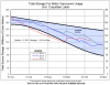
Look at the jump in the main Seattle reservoir...
http://2.bp.blogspot.com/-vXN1rtpG_kw/Vjg3dWqJjZI/AAAAAAAAi70/9zEegsJSLpw/s1600/USGS.12115900.01.62614..20150701.20151102..0..gif
Back to almost normal now... but next year is dependent on snowfall over the winter. Not worried about drought up here at all. We did really good through this dry spell per Cliff Mass.
Reservoir levels up here are looking much better as well. Running higher than this time in 2014 and 2013.
And this is before all the rain we have had the last little while.
-
(If again.) Scheduled to have been brought online at 0400z, with having checked (main "google" search.), .. I'm not seeing anything about the switchover, whatsoever. More official notice / announcement, "News" related to the idea, or commentary more basic.
U.S. National Weather Service (NWS)The National Weather Service’s primary and only global model, the Global Forecasting System (GFS), was upgraded today. The upgrade more than doubles the resolution of short- to medium-range forecasts going from 27km to 13km. This improvement uses more detailed topography, and thus will provide forecasters with more detailed information about precipitation, temperature, and winds so that they can provide more, accurate and reliable forecasts.
Improvements at NWS http://1.usa.gov/1xuZVqa
See the model http://mag.ncep.noaa.gov/
-
Where's Rob? 00z is looking "different"


October 2016 Observations and Model Discussion for the Pacific Northwest
in West of the Rockies
Posted
Whats crazy, or should I say Sad, is that it has rained the last 27 out of 30 days here!