


OmahaSnowFan
-
Posts
2693 -
Joined
-
Last visited
-
Days Won
1
Posts posted by OmahaSnowFan
-
-
Take out the stripe of snow for the current storm and you have nothing the next 16 days unless you’re north.
-
36 minutes ago, The Snowman said:
Fascinating, models still want >6" in Omaha. Just don't see it. Would love to be wrong.
It seems to be at least trying to set up further north. Still fighting the D**n dry air though
-
 1
1
-
-
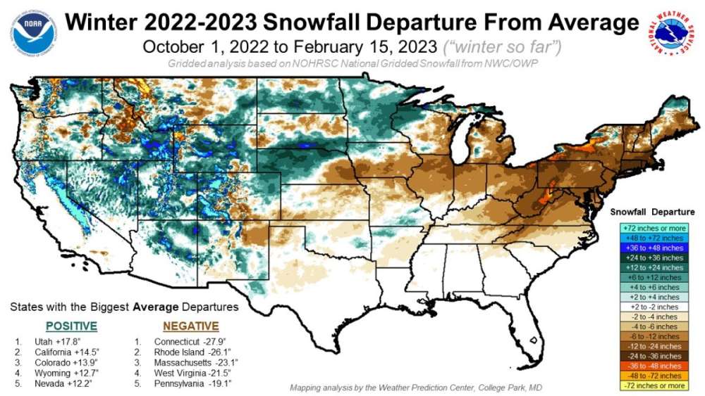
Ouch. I know every winter is forecast to be epic on this forum, but this is an ugly map for most.
-
 1
1
-
 2
2
-
 1
1
-
-
1 hour ago, Bryan1117 said:
What a complete dog *#%@ Winter here… honestly I didn’t think it could get any worse than last year, however here we are again. At least we will be back in the mid and upper 40’s this upcoming weekend, so it’s not like it will be cold after this system passes by.
With no snow it’ll warm back up pretty quickly this weekend and there’s no long bouts of super arctic air on the horizon either. Every storm system with colder air behind it immediately gets replaced with warmer air a couple days later. About the only good news here..
-
1
-
-
-
I’m just southeast of the town of Bennington, so this matches with what my bitter/jaded forecast of 1.5” is for my backyard.
Plus it keeps us in single digits for snowfall for the season. Something to shoot for.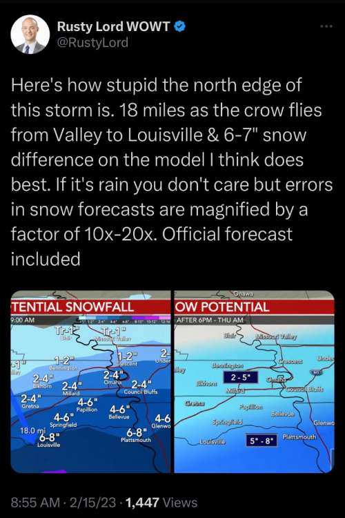
-
1
-
-
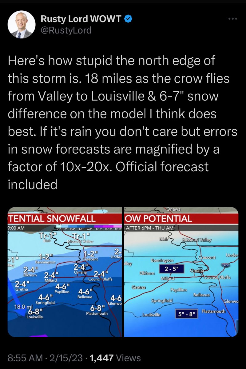
That gradient on the 0Z HRRR

-
 2
2
-
-
29 minutes ago, jcwxguy said:
not jims forecast but from nws
Right. I should have clarified

-
Jim is back on Facebook and posted this a bit ago.

-
3
-
-
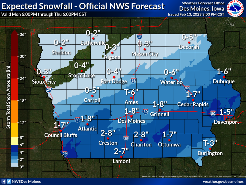
Heavy snow in the grids with 3-7" forecast.... and no warning or even an advisory for me.
Wednesday NightSnow. The snow could be heavy at times. Patchy blowing snow before 3am, then patchy blowing snow after 4am. Low around 14. Blustery, with a north wind 16 to 22 mph, with gusts as high as 33 mph. Chance of precipitation is 80%. New snow accumulation of 3 to 7 inches possible.-
4
-
-
Hit 62 yesterday and have had only 1 day below 40 degrees for a high thus far this month. Warmest high since last November as well.
Today, I’m up to .76” of rain that is basically just running off everywhere due to the still frozen ground.
Now to wait for the next whiff tomorrow night and Thursday!
-
Things look pretty good here, but no advisories.
Also, my NWS grid forecast has 2-4” of snow but “only” a 60% of snow. Normally you’d see 80-100% precipitation chances with a forecast like that.
-
4
-
-
1 hour ago, Grizzcoat said:
Dmx going out on a limb
I feel like these wide range forecast maps are new this year…
-
2
-
-
When the Icon is the best model for your backyard, you’re losing.
-
2
-
1
-
-
Forecast high of 60 tomorrow, and then .5-1.0” of rain on Tuesday.
We’re now down to a 50% chance of snow for “the big dog” Wednesday night, and after a brief 2 day cool down, it’s right back to highs near 50 next weekend.
-
1
-
-
It’s probably better odds at this point that the snow falls between Omaha and KC.

I posted an update in my thread asking how much snow do you think you’ll get during what was supposed to be a cold active period for most with ensembles showing beautiful clown maps turning the country into a glacier. I even gave a full 3 weeks from 1/24-2/14.
I’m going to end that period with 1”.And now it looks more and more like this storm will give us an inch if we’re lucky. I’m at 8.1” on the year.
-
1
-
1
-
2
-
-
NWS Omaha definitely makes you pull back your expectations.
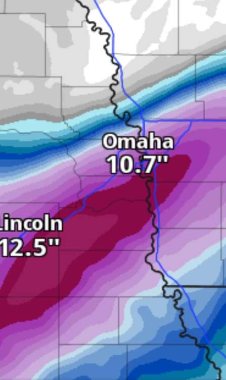
There will be a 12-18 hour break before the next round of
precipitation moves in by Wednesday afternoon, then winding down
through the day Thursday. Models are in still decent agreement
and suggest the potential for several inches of snow in our
forecast area, although the mean axis of the heaviest snow has
shifted slightly southward with recent model runs. Temperature
profiles are slightly colder with the mid week system, and thus
precipitation may begin just as snow, with not much chance for
rain at all. Through the event, we`ll also see northerly winds
increase to 15 to 25 mph, with gusts up to 35 mph possible, which
will create areas of blowing and drifting snow as well. WPC still
indicates a 30-50% chance of QPF exceeding 0.25" for this event.
The experimental Probabilistic WSSI still suggests a 40-60% chance
of minor winter impacts, a 20-40% chance of moderate impacts, and
even a 5-10% chance of major winter impacts. While it`s still
beyond our QPF window for snowfall forecasts, NBM is suggesting a
wide swath of plowable snow (a few inches) in our forecast area,
with the heaviest axis along/south of I80. NBM also suggests
suggests a 30-50% probability of 6 inches, and 20-30% probability
of 8". And there seems to be decent support from both the 00z GEFS
and EC ensembles, although amounts are a little lower from these
two models. For Omaha, the GEFS spread among its members is from
a trace to 8 inches, but the mean is about 3". The mean from the
ECENS for Omaha is about the same. The heaviest axis seems to be
setting up just south of I80.

While it`s still a day too soon to discuss details as there is still
some model uncertainty on the exact track and the amounts,
forecaster confidence remains medium to high that a winter storm
will impact the region later this week. It`s now within the WPC
winter storm outlook window on Day 4, which has large area of
30-50% chance of meeting winter storm warning conditions ending at
6 am Thursday, with a smaller area of 50-80% for southeast NE.
Certainly it looks like a solid winter weather advisory, and time
will tell if we will eventually need a winter storm watch.
-
3
-
-
37 minutes ago, Bryan1117 said:
Even though things look good for Eastern Nebraska right now... I am not getting my hopes up. Plenty of time for our friend up north (hawkstwelve) to reel another one in, as I don't think that the models are going to be much help until about 24 hours before this second wave is supposed to hit (if that).
Yep something will go off the rails here pretty shortly
-
2
-
1
-
-
Well the 3 weeks is almost up (2/14) and since I won’t be getting any snow before then, I figured I’d update my total.
1.
That’s right. The “active and cold” period delivered a total of 1” of snow for my backyard.
-
1
-
-
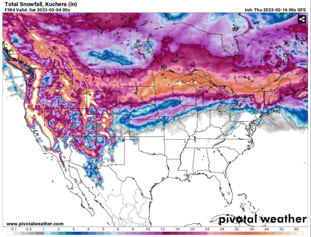
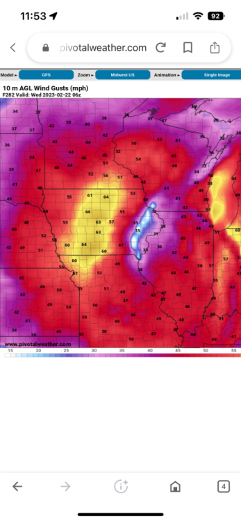
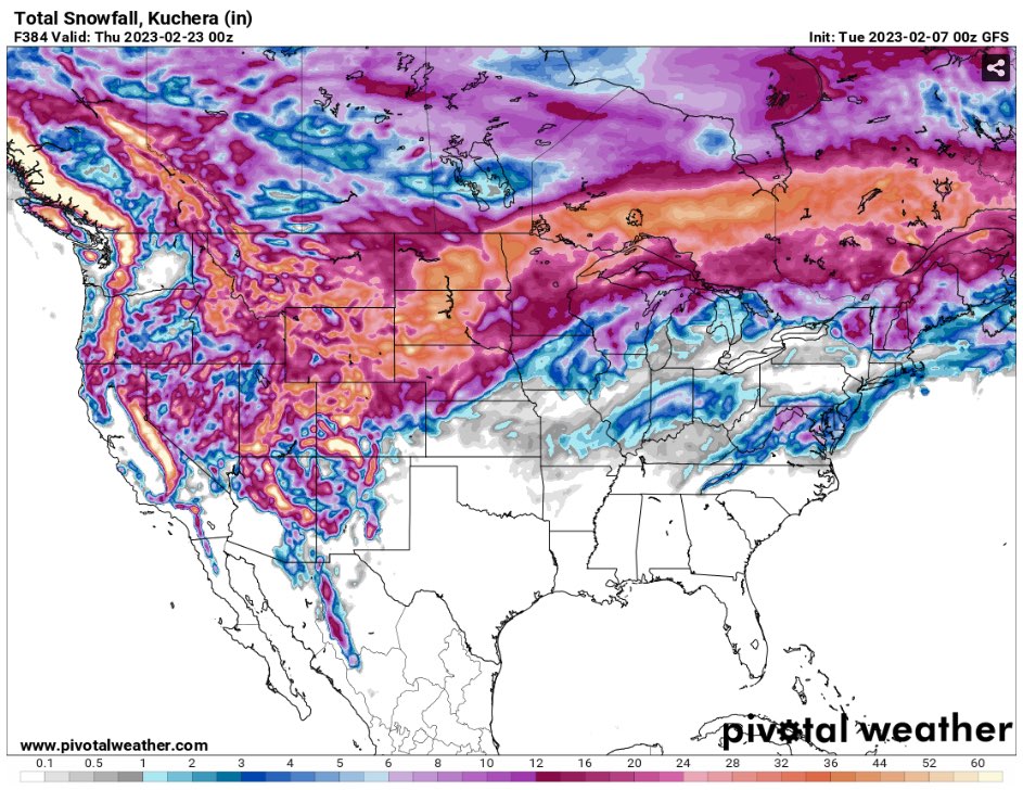
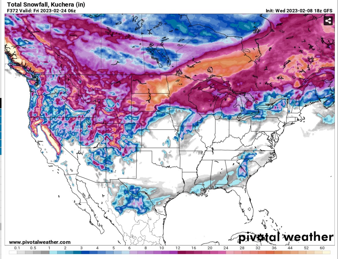
The Omaha snow shield is still clearly there on the GFS. Only 39” when Iowa gets 6 feet? C’mon!
Here’s forecast wind gusts too from one of the systems after next week’s storm.
-
1
-
 1
1
-
1
-
-
55 today and this map. Let’s have spring/summer already.

-
2
-
 2
2
-
 1
1
-
1
-
-
Quite the run by the 0Z GFS…. If you’re in the same areas that have been hit all winter, i.e. north and west.
-
1
-
1
-
-
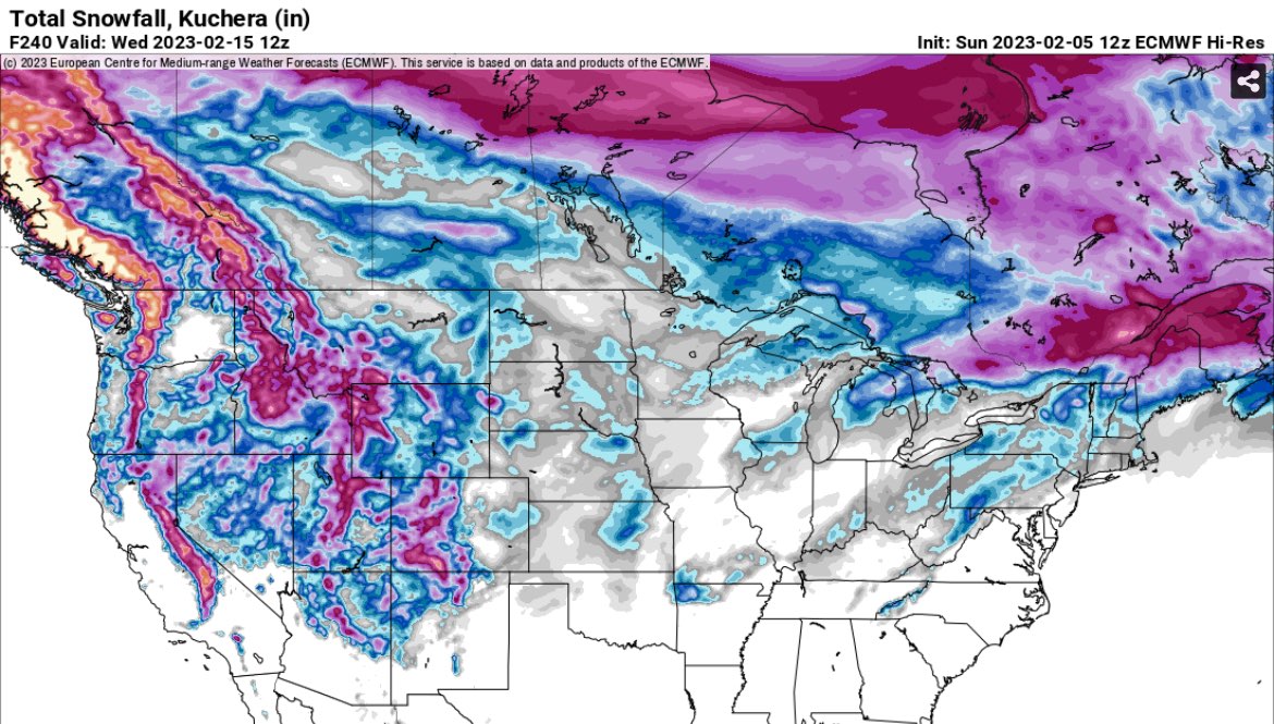
Ouch, the Euro yesterday was showing the 12” snowfall while the GFS was showing 2 separate pieces and little snowfall.
Now the 12Z Euro has matched the GFS and has 10 days of nothingness.
-
2
-
-
Storms gone on the GFS and a rainmaker for the Euro, and then it’s going to turn cold? Yay brown and cold it is.
-
3
-


2/14 - 2/17 Cutter and Panhandle Hook
in East of the Rockies
Posted
Measured 6” on my trusted measuring spot- the roof of the dog house in the backyard that’s sheltered from wind.
What a nice surprise for once AND I get to use my brand new snowblower for the first time that’s been sitting in the garage since the beginning of December
