


uticasnow
-
Posts
97 -
Joined
-
Last visited
Posts posted by uticasnow
-
-
6 minutes ago, Pros3lyte said:
Wow. DTX Goes earlier than the rest with the WSW! I can't remember a time in the last 10 years when DTX has jumped on a headline sooner than any other surrounding offices. We're usually the last office to commit to anything, often waiting until the precipitation almost starts. I'm actually blown away.

Winter Storm Watch
...WINTER STORM WATCH IN EFFECT FROM FRIDAY MORNING THROUGH
SATURDAY MORNING...

* WHAT...Heavy snow possible. Total snow accumulations of 6
  inches or more possible. Winds could gust as high as 50 mph.

* WHERE...Midland, Bay, Huron, Saginaw, Tuscola, Sanilac,
  Shiawassee, Genesee, Lapeer and Livingston Counties.

* WHEN...From Friday morning through Saturday morning.

* IMPACTS...Travel could be very difficult. The hazardous
  conditions could impact the evening commute. Blowing snow will
  be possible resulting in reductions of visibility. Gusty winds
  could bring down tree branches.

* ADDITIONAL DETAILS...Uncertainty exists regarding the northward
  progress of the rain/snow line Friday which greatly impacts
  total snowfall amounts should snow mix with rain or briefly
  change over to all-rain. Snowfall rates are expected to peak
  Friday evening with maximum rates near 1 inch per hour across
  the Tri-Cities and Thumb regions. Very strong winds are
  expected Saturday with gusts of 40-50 mph possible as arctic air
  filters in behind the system sending wind chill values into the
  single digits Saturday.
Of course the southeastern part is not included as it will change to RAIN once again,...and again...and again
-
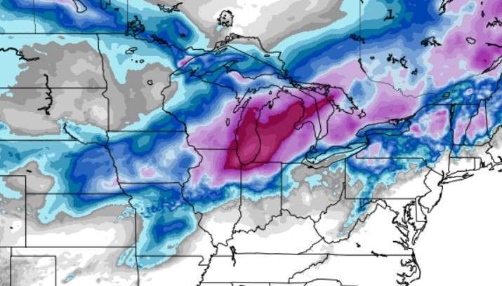
Total EURO Snow through hour 84
-
 1
1
-
-
EURO HOUR 60
SLAM!

-
 1
1
-
-
CMS HR 96 (10:1)

-
3
-
-
-
GFS Hr 78

-
1
-
-
-
Hour 66 On GFS

-
2 minutes ago, Pros3lyte said:
Honestly I’m not getting my hopes up in the least. I fully expect this to turn into a rainstorm for us- or at least enough mixing to keep us at advisory criteria. The central part of the state is going to jackpot though for sure
I hear ya!. Same old story down here. I guess we have the lakes to our east to thank for screwing us over everytime.
-
6 minutes ago, Money said:
Icon at 69. Same mb and location as 18z
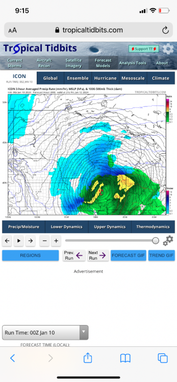
ICON goes crazy for southeast Michigan but then changes to SUPRISE! (RAIN! )
-
 1
1
-
 1
1
-
-
Come ON!...We need this is southeast Michigan. Only a trace of snow so far this season. It's been pathetic
-
2
-
-
10 minutes ago, Hoosier said:
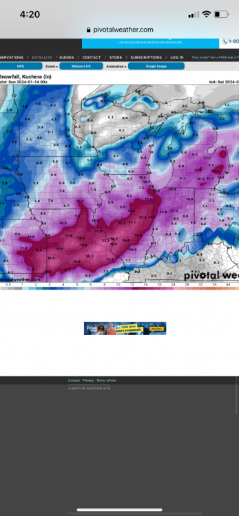
Would be epic totals in northwest IN. Already 20" at the end of the run with hours of snow to go.
I thought the map showed 8.4" in northwestern Indiana
-
5 minutes ago, Chambana said:
Little worried I may be a shade too far south, maybe not. Legit blizz conditions looking likely for a lot of people regardless.
Can someone post maps?
-
Detroit was hinting thisi morning that temps are trending a little cooler than previously forecast:
A forecast trend from 24 hour ago has
been for a slight delay precipitation onset. It is quite possible
that snow will hold off until after the morning commute particularly
north of M 59 and/or I 69 corridors. The other change has been for a
slightly cooler atmosphere column by a degree or two Celsius. As a
result, there is lower confidence on when precipitation will
changeover to rain. Given the projected UVV response, more efficient
wet bulb cooling could delay the changeover to rain by an hour or
two. Thus, preference is to carry snow accumulations through noon for
many areas particularly in the higher elevation of the Irish Hills
-
1
-
-
Just now, Tony said:
At least the 12z Euro is bringing back some love for the Chicago folks and a few others.
is The Euro trending southeast?
-
Actually it started trending north 4+ days ago from when we first started tracking the storm
-
1
-
-
Just now, mlgamer said:
I think the disappointment for some is the storm taking a decisive turn north late in the game.
Yes
-
7 minutes ago, ATW said:
We’re screwed by thermals alone.
I know alot of people are dissapointed by this storm, but in all reality the thermal profiles and lack of cold air was known well before all the hoopla took place.
-
4
-
-
11 minutes ago, Money said:
GFS
Lock it in!. It will only change 100 times between now and then!
-
 1
1
-
-
1 minute ago, tStacsh said:
From south all week to a Rainer. The models also slowing down in the longe range. These models suck outside 3 days. Like really suck.
Same old story for us in SE MI. Fun to watch the models, but in all reality it ends up rain, or a slopfest.
-
1
-
-
2 minutes ago, Tom said:
Still a solid hit for many on here...
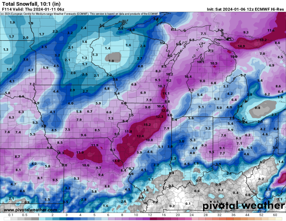
This shows 10-1 ratios but reality is you can probably cut these totals in half with the warmth
-
14 minutes ago, Tom said:
Timing is everything...The Snow God's are listening!
Not here in southeast Michigan. Was lookig pretty good for a half way decent snowfall with this upcoming storm but as always
ends up being mostly rain.........what a dissapointment (again).
-
 1
1
-
-
For us in southeast Michigan there is no sense in getting excited because the WARM air takes over almost 90% of the time!
-
1
-
-
Didn't see the same post til I looked at mine!


January 11-13 Major Winter Storm/Blizzard
in East of the Rockies
Posted
Of course Macomb County not included the Winter Storm Watch..................................