


Jayhawker85
-
Posts
300 -
Joined
-
Last visited
Posts posted by Jayhawker85
-
-
14 minutes ago, winterfreak said:
Huge bust here in the city so far.
Looks like there is dry air over the city that is keeping it on the west side. The next wave from Topeka should help with that issue
-
 1
1
-
-
9 minutes ago, Clinton said:
It's a nice snow to close out the Winter on and it will push us above average for the season. I think this will be our last snow and then it will be on to a very crazy severe weather season imo.
I think we have 1 more snowstorm before the season is over. Don’t we have that one system that came due south from Canada that gave Iowa and eastern Nebraska like 10 inches of snow?
-
2
-
-
Snowing is coming down nicely and radar is looking pretty good!

-
 1
1
-
-
1 minute ago, mlgamer said:
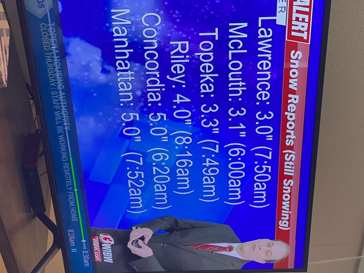
I have nearly 3" in MBY with moderate to heavy snow falling. A NWS employee near me reported 3.3" just before 8 AM CST.
The radar looks good for the moment and this could be my biggest snow of the season. A storm total of 3.4" would push Topeka over 20" for the season for only 2 of the last 8 winters!
I’m excited for you to get what you been waiting for all winter!!
-
1
-
-
16 minutes ago, someweatherdude said:
Wow. 12z NAM just gave KC the middle finger. Yet another reason to take the models with a grain of salt. They can change up to the time it starts snowing--and after. And I'll take a bow for saying I was worried a few days ago that the heaviest snow could end up south of KC.
Aren’t the global models not too reliable during the storm? I would just watch radar and the short term models since we are in the storm
-
1
-
-
30 minutes ago, Clinton said:
Not alot of change with the 12z models


Models are coming into agreement with the GFS that this should be a 1-70 and south snowstorm like it was the previous cycle. Hopefully the NWS can get their map updated to reflect
-
1
-
-
3 minutes ago, someweatherdude said:
Funny. He has the heaviest stuff southeast of the city. NWS has it northwest of the city. Gary's looks closest to the GFS, which I understand he tends to favor (and which has outperformed the Euro for the KC area this year).
I don’t get the NWS snow map either. All the models show the heaviest band over and south of the city but they have the band 2 counties north. I’m sure they will be changing their map or have egg on their face tomorrow
-
2
-
-
Just now, winterfreak said:
The differences in placement in modeling is astounding this close.
The models this season just love being so different and spread out so close to the event. Luckily the GFS has been pretty reliable compared to the other models but this time tomorrow we will see who will be the winner
-
1
-
-
21 minutes ago, Clinton said:
18z ICON with some hefty amount between Topeka and KC


Do you have the GFS 18z?
-
53 minutes ago, Clinton said:
12z GFS, CMC and GEFS


Bring out the snow blowers!
-
1
-
-
3 minutes ago, OmahaSnowFan said:
12Z GFS sticking to it's guns. Was the first to go south and then all the other models followed it.
The next 24 hours will be if the other models follow the GFS or if the GFS will cave to the more northern track. The GFS has been pretty good within 48 hours the last 5 storms we had in the kc area
-
1
-
-
1 minute ago, bud2380 said:
GFS just shifted several hundred miles south. Hard to trust that model right now. It's had a very rough winter. Hard to put much stock in it right now.
I believe this system will push south with strong high pressure pushing in fr the North. It looks like it’s going to be moving south of 1-80 and between 1-70 at the moment
-
Had thunder snow then sleet snow mix and now back to snow. From the looks of radar we may get a inch and half maybe 2 if we can get some back build
-
3
-
1
-
-
Getting thunder sleet here in lawrence
-
2
-
-
Per Gary’s blog this morning
This is evolving now, and we will see if the models continue trending into this solution. Here is what I wrote to a Weather 20/20 customer in mid-December for this next week: "This period will begin with a great chance of our biggest snowstorm of the season." So, this next storm has been on our "LRC Radar" for over two months to arrive in these next few days.
-
2
-
-
Have a solid dusting here. Waiting to see if radar returns start to increase
-
2
-
-
Just looked out the window here in leawood and we have Light snow falling and a very light dusting. This wasn’t in the forecast for today!
-
2
-
-
3 minutes ago, Clinton said:
12z FV3

This is steadily moving North each run. At first St Louis was in the bullseye and now they might not even see a flake.
-
2
-
-
5 minutes ago, Clinton said:
0z RGEM and GFS in agreement for a widespread light snow event with a narrow band of higher totals.
0z GFS


0z RGEM

Looks like this will be an advisory event with widespread 1-3 inches
-
3
-
-
1 minute ago, Clinton said:
You may be right but the setup is almost identical. Before February I had 1 inch of snow for the season, I have had 15 inches with the last 2 snows. Our area is in a hot spot right now.
How did the next storm track in the first cycle?
-
28 minutes ago, Clinton said:
Are you ready to do it again next Thursday?
Idk. My heart is still recovering from this stress event lol
-
 2
2
-
-
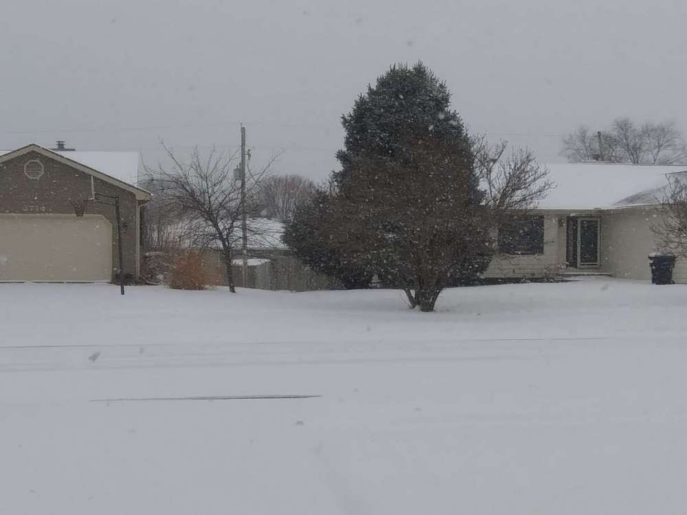
Got 8.5 here in lawrence with 1.5 foot drifts
-
3
-
1
-
 1
1
-
-
19 minutes ago, someweatherdude said:
Seems high. Where'd you see that? Nevermind. I see it on the NWS snow report page. Still seems high. But it's blowing around quite a bit. So tough tell.
Many places on the west and southwest side of town is reporting 8-11 inches right before the last heavy band moved thru
-
2
-
-
Kci just hit the daily record for snow on this date with 6.4 inches and counting
-
1
-
1
-

3/9 - 3/12 Spring Storm
in East of the Rockies
Posted
Report of 6.7 inches in Lawrence! We ready for wave #2!
the dry air really played havoc over kc with general 1-3 inches. Maybe the 2nd wave can produce a extra 1-3