


Shawn
-
Posts
50 -
Joined
-
Last visited
Posts posted by Shawn
-
-
Down to 38.4 at my house just outside of Scappoose. Snowflake just showed up on my Davis Vantage Vue. Looking forward to seeing what happens here. If there is anything to post I will post it.
-
 3
3
-
 1
1
-
-
Had a beautiful hike and swim (in that order) at Council Lake west of Mount Adams today. It was in the low 80s up there. A lot cooler than the lowlands but still pretty warm for the 4,500-5,000 ft level.
Mt. Adams and Council Lake from Council Bluff.
 4B4475DB-9881-41DF-AD04-B073FCA5EF05.jpeg
You can make out the close to first quarter moon directly above Adams too.
Great shot with no clear cuts.
-
1
-
-
Just hit 10" for the month.
-
3
-
-
-
Bedtime for me. Just wanted to say hello.
Here comes Johnny
-
1
-
-
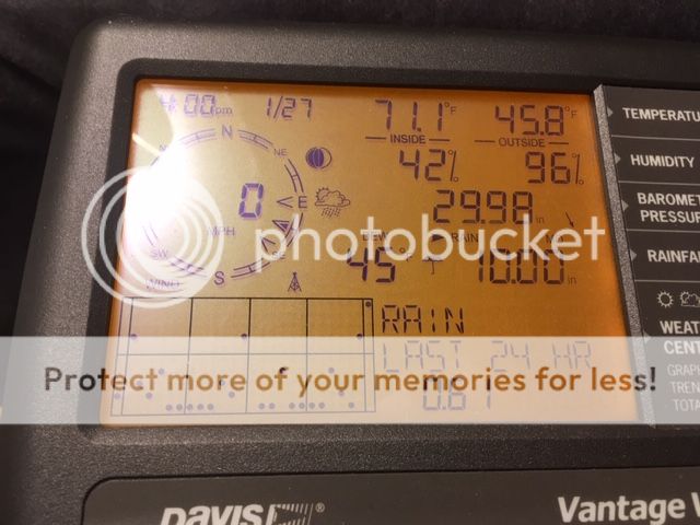
.75 inches for the day
6.67 for the month so far
still 41 degrees
-
41 at my location in S. Scappoose
48 in Hillsboro
47 in Salmon Creek to my east
Its coming been slowly moderating today. Usually get a quick gust of warm wind and temps when this happens, but there not much of a spread this time.
-
-
1
-
-
Someone have a good radar link? NWS Seattle must be overloaded since I am having trouble loading the page/radar.
https://atmos.uw.edu/current-weather/northwest-radar/#controls
-
Look at that Fuucking Columbia River Convergence kicking in to my door step.
Just like the ECMWF said, wind going backwards.
-
2
-
-
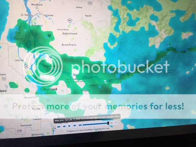
Snowing down to at least 900’ in scappoose now.
My Brother just text me saying snow at his house at 800' up JP West.
-
Anyone know where I could find a storm report for Skykomish? Or snow depth? Looks like they got really hammered today. Looked on NWS Seattle and couldnt find.
-
Weirdly our night model runs seem to be far more disappointing than our day runs. Just a little observation from the past few weeks.
I dont see why your disappointed. With your elevation you would do great with gfs and euro. I think you will be fine.
-
1
-
-
So where do I find the projected snow levels in my area from now until Monday?
Here is the zone forecast. When snow levels are low enough they will show up for your area.
https://www.wrh.noaa.gov/forecasts/display_special_product_versions.php?sid=sew&pil=zfp
-
1
-
-
Ok so this evening just got a bit worse for me, my dr. called and informed me of the results of my CT scan and it is cancer, according to my dr. it is treatable and won't involve any really invasive treatment/s.
Sorry this is happening to you. You will be in my thoughts and prayers.
-
2
-
-
That is an insane block that sets up in the long range on the 18z. Completely shuts down the Pacific. Not super amplified, but I would not complain.

Looks good to me for a inside slider.
-
Congrats on your White Christmas!
Thanks. I dont live that high. Just went for a drive. Its just up from my house. Great to see on Christmas Eve.
-
2
-
-
Snowing at 1500' in Scappoose.
-
4
-
-
1.48" since midnight
3.09" storm total
53 degrees
6 miles sw of Scappoose Airport
-
1
-
-
Storm total of 2.23" in Scappoose.
-
3
-
-
1.33" of rain for the month of November in SW Scappoose
-
1
-
-
Here is a couple of live cams to watch in Ashland. Should get interesting down there.
-
1
-
-
026 PM PST Sun Feb 10 2019
.NOW...
A strong front will have the potential to produce a stray
lightning strike across the central and northern Willamette Valley
and adjacent Cascade foothills late this evening. In addition,
snow levels will temporarily lower back down to near the valley
floor in the central and northern Willamette Valley. However, snow
accumulations will primarily be limited to elevations above 1000
feet before snow levels rise even further later tonight.
There here with us, right now, reading all our weather secrets....
-
Interesting...Maybe the heavier precip? Or maybe the southerly surface gradient is relaxing a bit?
On the wundermap you can see the rain snow line being pushed back south toward portland. Winds are calm here now also.
April 2022 (April 2008/2011 redux)
in West of the Rockies
Posted
Just switched over to snow here. 35.4