


NorthBurnabyWeather
-
Posts
23 -
Joined
-
Last visited
Posts posted by NorthBurnabyWeather
-
-
The last few days have been pretty humid, but I noticed much cooler breezes this afternoon. What's been going on at the BC/WA surface/mid-levels over the past 12-24 hours that can explain this?
-
Have the Puget Sound Lowlands ever gotten a thunderstorm-related WW? I'm not talking about SW WA (Olympia, Cowlitz County) where such WWs aren't actually very uncommon, but the more populated areas along the Duwamish River/Elliott Bay drainage areas and the Cascade foothills.
-
When was the last time a heat wave ended with widespread thunderstorm activity in coastal sections of WA/OR/BC, instead of the more typical marine push and shifting winds?
Continuing on that subject, has there ever been a cycle of heat, storms, more heat (i.e. the storms don't bring much relief) in these parts? Such a pattern is fairly typical in the Mid-Atlantic
Finally, will this forthcoming monster heat wave bring elevated humidity levels and lows in the 70s? Like, 3pm dewpoints in the upper 50s-low 60s (15-17 Celsius), pretty much Arizona monsoon-level.
-
The pre-storm orange sunset in Vancouver on 7/25/09. I'm still not sure how that was caused
-
Willamette Valley wipes the floor with the Puget Sound lowlands and Bellingham/Metro Vancouver for thunderstorm development and it's no contest. No geographic barrier against moisture flows (like the Olympic Peninsula/Range and Vancouver Island) since there are gaps in the Oregon Coastal Range near Portland/Vancouver; plus the more southerly latitude and the topography of valleys supercharges daytime heating.
- 4/5/1972 North Portland/Clark County F3
- 1/10/2008 Clark County EF1 and accompanying supercell
- 6/4/2009 severe warned storms in Portland
- Also note that on 8/12/14, the SPC WAWAs were all south of Lewis County
I don't think Seattle, Mount Vernon or Bellingham have ever had SPC WAWAs, not even from the storms 4 weeks ago (most of the action was around Olympia/Lacey) or 5/31/97.
-
Hottest: July 21, 2002 in Chicago (where I was on vacation). The AT/DP split in the south west suburbs (where my aunt's house was, I was staying with her family) was 97/70, 106-107 heat index. WIthout exaggeration, I thought I was going to die. Besides a brief soujourn to the Maryland suburbs of DC the previous summer (and even then it was more of the typical 88/69DP Mid-Atlantic kind of summer), I had never up to that point been exposed to conditions even a quarter as hot or humid. And I was only 11 at the time, so I was very young. My aunt and uncle had me stay indoors that day as much as possible.
Coldest: Probably the cold snap of February 2014 in Metro Vancouver. -10ish in Burnaby?
-
I think Portland's summers are a lot more arid than London/Paris because the monsoonal influence in the PNW is nothing compared to the hot/humid spells that can be triggered by Spanish Plumes coming off the Iberian Peninsula, which also trigger violent thunderstorms.
-
There are plenty of threads discussing memorable weather events during the colder months, like windstorms, heavy snow events, etc. However, I don't think there's a thread discussing the extreme weather events that can happen in the warmer months, like thunderstorms and heat waves.
Obviously they're a lot rarer west of the Cascades than they are in the Paulouse, central WA/OR, the Idaho Panhandle, etc. (where thunderstorms and wildfires are pretty common in the summer, and even haboobs can occur), but that doesn't mean they can't happen in areas closer to the coast. Especially in the Willamette Valley which gets pretty hot; days in the upper 80s and lower 90s are a lot more common than in the Puget Sound lowlands or in Whatcom County/Metro Vancouver, and the warmer temperatures (plus the fact that Portland is situated further south) can fuel more potent thunderstorms than one might expect for the PNW.
As an example of this, I don't think the Puget Sound lowlands have ever had a severe thunderstorm watch/warning, ever. However, the Willamette Valley/SW WA have had a handful of severe-warned events. Clark County seems to get the brunt of it. There was the F3 tornado on 4/5/1972 that tore through northeast Portland before killing six people in Vancouver; the 1/10/2008 supercell that also hit Vancouver (ironically, both of these events were during the colder months); the 6/4/2009 severe thunderstorm event in the North Valley; there was even a severe thunderstorm warning around the Columbia Bar area (e.g. Astoria) during the Ides of October windstorm last year. Not to mention the 8/12/14 severe thunderstorm watch for Cowlitz County.
Anyway, I'm getting ahead of myself. What are your memories of extreme warm weather events that occured west of the Cascades? The 106 degree day in Portland, the 8/3/1999 thunderstorms, the 8/29/2015 summer windstorm, the 6/28-7/3/2013 heat wave (with elevated humidity levels); for you older folk, the 8/23/1993 thunderstorms where that jogger on the Eastside was fatally struck by lightning, etc.
-
I know it's February, but I've always wondered: what do you think have been the most catastrophic fire weather scenarios in the PNW throughout history. Like, a complete burn ban for all of WA/OR/ID/MT, on top of a complete campfire ban for all of British Columbia. Summers of 2003, 2014 and 2015 spring to mind.
-
Hi all,
I hope you had a good holiday.
Over the holidays, I've been trying to get a handle on upper air and surface analyses, and see if I can deduce the setup to thunderstorm events. Why did BC's Lower Mainland and Fraser Valley get rocked on August 7, 2012 and May 2, 2016 while Seattle and Portland were untouched? Why did Seattle get storms on August 2, 2014 but Vancouver did not? That kind of thing.
Growing up in the Northwest all my life, studying upper air charts via Plymouth State University have allowed me to recognize several "over-arching" setups for warm-core convective events west of the Cascades:
- Type I: Shortwave trough, no onshore flow through depth, southerly surface flow: These "monsoonal plume" kind of events are a part of summer when you get east of the Cascades, but for them to happen in the interior lowlands of W WA or the Willamette Valley, the onshore flow has to be cut off. This is possible if the North Pacific High is located unusually far south and west (closer to the Hawaiian islands), there is robust monsoonal activity (and a mid-level (about 500 hPa) anticyclone) in the Desert Southwest, and a trough is located in the right position. The main danger is wildfires since there is abundant dry lightning. Virga is not uncommon. Examples: September 2-3, 2009; August 2, 2014
- Type II: Cut off low off the OR/CA coast, no onshore flow through depth, monsoonal moisture: The second primary lifting mechanism for warm-core convective events is a cut off upper level low (cut off meaning it formed independent of the jet stream) spinning off the Oregon coast, which can tap into warmer water off Baja California or a monsoonal trough over land. Couple that with residual heat from a weakening desert high, and you have a recipe for fireworks. As the cells are pushed over the Cascades, high-based lightning becomes more frequent. Examples: August 9-10, 2013; August 11-13, 2014; August 14, 2015
- Type III: Cut off low off the OR/CA coast, no onshore flow through depth, mid level Pacific moisture: An uncommon cousin of type 2, if there's abundant mid level moisture (like an atmospheric river of the remnants of a Pacific hurricane), you can get drenching thunderstorms that are more characteristic of the Midwest or East Coast. Examples: September 5, 2013; July 20, 2012
- Type IV: Upper level low churning over E WA: Extremely rare. If there's a closed cut off low located east of the Cascades and sufficient daytime heating, it can push storms east-to-west, forcing them over the Cascade crest and intensifying them. Examples: July 25, 2009
I have attempted to teach myself mesoscale analyses, but I'm having a lot of trouble. I received a lot of great information from the other replies in this thread, but I want to go to the next level, to the quantitative "nitty-gritty". I thought I would start with 8/2/14 since it was the day that that guy recorded himself being struck by lightning on camera. Here's what I have so far, using nullschool.net since I found their dynamic and interactive animations meant it was easier for me to switch heights and times. If you'll indulge me:
Thursday, July 31, 11am: An immoving Omega block is over Aluetian Islands. The North Pacific high is unusually south and west, allowing it to tap into the warmer waters of the tropical Pacific, and lead to a bit of an "atmospheric river" effect along the west coast of North America. There's a better shot of the Pacific high at 250 hPa, which also lets you see the vigorous low (~5700dm; try as I might I was unable to find archived barometric pressure map data (using mbar); nor could I find a way to convert geopotential heights into rough barometric pressure) located 950 km off Haida Gwaii. The "river" airflow and the upper level low airflow are converging over the west coast of Vancouver Island.
Friday, August 1, 8pm: The shortwave trough starts forming over the interior lowlands of W WA, and a 500 hPa desert high strengthens, intensifying the warm, southerly flow aloft. 700hPa shows the nocturnal low level jet stretching from the Klamath Range all the way to the Willemette Valley.Saturday, August 2Unfortunately, I've become a bit stuck. It was straightforward to get a "big-picture" look from the nullschool visualizations, but I'm not completely satisfied. Nullschool's visualizations only go as far back as 2013-11-01 00Z. Upper air charts on Plymouth State University's website, on the other hand, go back 60 years. The NWS has a large historical archive of surface charts so I'm fine there. I guess what I'm trying to say is, how do I know what to look for? There is so much information that you can map via PSWC: just look at the list! My gut instinct tells me that I should probably get schooled in DIY mesoscale analysis, like through theweatherprediction.com, before I start jumping into charts and whatnot. But, at least you can see what I have so far.
If you're still reading so far, the TL;DR is as follows: what would I have to know to write something like this, but for 8/3/99 or 9/5/13 in the Northwest, rather than 4/27/11 in Dixie.
-
While I don't know if there is free environmental Canada archived data, or if it exists if it is also free, the other data sets you mentioned are quite good. What are you trying to do?
Oh no, it's just out of morbid curiosity. I'm not disagreeing that the products to which I linked are very good. I just found it curious why NOAA archived its charts, but Environment Canada does not. I don't think differences in population would explain it.
-
Plymouth State University has surface and upper air analysis charts (e.g. soundings) for the United States, and NOAA has archived analysis products stretching back to 1998 through the SPC. Is there an archive of Environment Canada analysis charts available on the internet?
-
The Weather Channel has this forecast for Seattle tomorrow:
Thunderstorms likely in the morning. Then the chance of scattered thunderstorms in the afternoon.which surprised me. I'm used to seeing "rain/thunder" or "t-showers", or "...with a few rumbles of thunder".
It made me wonder if TWC has ever forecasted "scattered strong storms", "scattered strong storms/wind", "strong storms", or "strong storms/wind" for the Seattle area. Or anywhere in Washington state for that matter. This also goes for the "a few storms may be severe" or "storms may produce large hail and strong winds" bit.
-
The weather here has been so darned stable...I never thought I'd say this, but I miss thunderstorms and heat waves. Metro Vancouver and the BC coast used to get a good solid two or three of each, every summer for the past couple of summers. Part of me wishes we could get the dangerous jungle-like heat and wild thunderstorms that are gripping the midwest/northeast right now. But I know that's impossible here because the waters around here are, too cold and the Rockies block any moisture from the Gulf of Mexico. All I can hope for is an active Eastern Pacific hurricane season and the remnants of a wayward hurricane getting tapped into a shortwave, or an upper low. Like the remnants of Hurricane Fabio in 2012.
On the other hand, this has been the first stable, PNW-esque summer around here since 2011. Cool temperatures, abundant marine influence, punctuated by a few days of overcast conditions and rain. I'm not begging for air conditioning, the reservoirs are filled, there's no drought, the whole region isn't on fire. Don't look a gift horse in the mouth I guess...
-
 1
1
-
-
I recently started a thread on heat events, inspired by all the talk of heat domes in the central and eastern U.S. as of late. While the following is related to heat domes, I thought it was more appropriate to post in here.
A side effect of heat domes is the "ring of fire" phenomenon, in which heavy thunderstorms develop along the periphery of a hot air mass. Examples include the "super derecho" in 2012.
My gut instinct is that geography gets in the way of "ring of fire"-esque events. The Rockies block moisture from the Gulf of Mexico while the Cascades block surface moisture originating from the monsoon down in Arizona.
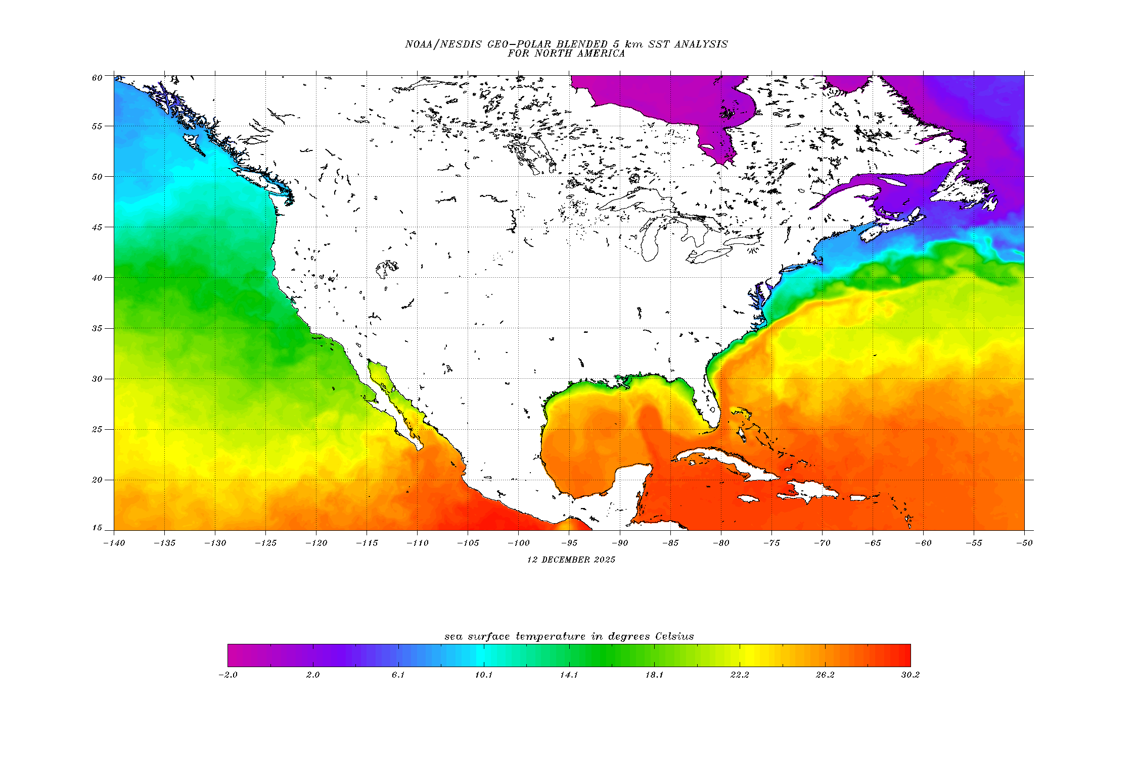
What's more, there's a lot less 28+ degree water in the Gulf of California and the tropical eastern Pacific, compared to the Gulf of Mexico as can be evidenced by NOAA's SST maps.
I think that's why thunderstorms in the western U.S. tend to be dry, and we don't get the kind of drenching storms that they get east of the Rockies.
You won't get them unless the source of moisture is something like the remnants of an eastern Pacific hurricane (like 7/20/12), or there's a freak progressive event like 8/6/97, 9/5/13, 8/3-5/99, 6/22/93 or 8/12/14.
-
1
-
-
While I doubt heat domes like the ones east of the Rockies can occur on this part of the continent, that doesn't mean there could potentially have been heat events with some characteristics of a heat dome--high pressure smothering a large area and keeping out any cooler weather or moisture. August 1981, July 1994, July 2006, July 2009, August 2012, June 2013 might be candidates.
-
1
-
-
Can any whizzes help me understand how in the world a sounding works?
I am trying to compare soundings between two days. One day was a day in which heavy thunderstorms were observed in southwestern BC (Aug. 6, 1997), and the other is a day more charactaristic of the usual summertime pattern of an onshore ridge of high pressure, clear skies and low dewpoints (Jul. 23, 2015).
I'll be using the Qualiayute soundings for reference, because it's the best analogue to Vancouver and the BC south coast that I could find. For the first event, I'm using the 00Z 8/6 and 12Z 8/6 soundings. These correspond to 17:00 8/5 and 05:00 8/6 in the PDT time zone. The storms started firing up mid-morning on the 6th and lasted until the mid-afternoon, so those two particular soundings I believe would be an apt thermodynamic "tale of the tape", as it were. For the second event, I'm using the 00Z 7/23 sounding.
I tried reading a "how to read a Skew-T diagram" page from the NWS Storm Prediction Center, but since I was a layperson it didn't didn't help me. They were glossing over the various types of isotherms and dry adibats and whatnot. I don't know what the solid lines represent and what the dashed lines represent, nor the yellow line in the diagram. Which one's the isotherm, and which one's the dry adibat, and which one's the wet bulb temperature profile? When it comes to the wind barbs, if they're sticking out to the northwest does that mean the winds are coming from the north west? Or is there some other counterintuitive orientation? (i.e. if the wind barbs are sticking out of the northwest, that means the winds are coming out of the *southeast*)
-
Thank you for your informative posts. I learned a lot.
I would like to see if there is any academic research on this subject. The NWS Portland office wrote a paper on the 1/10/08 tornado in Vancouver, WA that included some climatology of severe convective weather in Portland, and that's as close as I've gotten:
Two synoptic patterns are locally recognized for producing severe convective weather in Portland's CWA. The first, more common pattern, occurs during the spring and summer convective season, and involves an upper level cutoff low off the northern California coast. The weakly sheared, dry environment supports mostly elevated, single cell storms, at times producing downbursts and hail. The 10 January 2008 tornado synoptic pattern falls in a second regime. This regime is more frequent in fall and winter months, and involves the approach or passage, of an upper level trough. [The region of tornado genesis on 1/10/08] was located on the cyclonic side of a strong polar jet, under mid level cold advection, with an onshore flow of moist Pacific air. This frequently occurs in a postfrontal air mass.
Which is informative, but I think the nuances of storms in the Willmette Valley are different from those of the Puget Sound, and those of Bellingham/Vancouver BC.
Does anyone have leads as to academic literature about thunderstorm climatology?
Our weather is so moderate that it's not worth studying! (Besides windstorms, of course)
-
Generally these soundings are just a brief snapshot and don't capture the best dynamics for us, which tend to be pretty fleeting. The July 22, 2000 thunderstorm outbreak for example was triggered by a shortwave moving quickly up the coast. The 00z sounding at SLE on 7/22 was relatively impressive
But as you can see, 24 hours later those dynamics had completely shifted north.
Like with snow, it's a very delicate balance for us in getting the right combination of elements for warm-core thunderstorms. There's always going to be a fine line between an encroaching cooler, stable marine layer and the warmer, moist unstable air. These conducive elements generally don't last too long, although in a less progressive pattern an event like August 1999 can happen where areas do see storms several days in a row.
After tooling around with the soundings, it seems that they don't represent a wide enough time frame for such fleeting dynamics (it's similar to the snow events you mentioned), so I want to ask you if you know the mesoscale setups in the PNW for some of these epic thunderstorm events:
-August 1999
-7/25/09 which hammered SW BC but not W WA
-July 2012, which hammered W WA but not Vancouver
-8/7/12 again which hammered SW BC and not W WA
-The thunderstorms in late August and early September 2013, which were the rarest of the rare, warm-core moist thunderstorms.
-8/11/14-8/12/14 which triggered the STW in SW WA
-8/14/15, which was the last warm core thunderstorm I can think of.
-
Definitely use Plymouth State's archived tools if you want some data
Look for the main sounding locations in the PNW. KSLE (Salem), KUIL (Quillayute), and CYZT (Port Hardy)
http://vortex.plymouth.edu/u-make.html
You can play around with these tools in various forms if you know what to look for. I'd recommend using SLE, as their parameters are going to be the most indicative of what the populous PNW lowlands see in most given events.
The best, basic tools you can use are Lifted Index and CAPE.
As an example, here is Salem's hodogram from a decent westside convective event way back on June 5, 1958
Note the LI of -5.8 and CAPE of over 1500 J/KG. About as good of a sounding as you'll ever see around these parts, really.
The best strong convective setups for much of the PNW tend to occur in the mid to late spring (late April to late June). That's when we by far will have the best combination of heating, 500mb dynamics, and moisture.
The ideal setup for a strong warm-core convective event is a strong upper level trough, cut-off low, or even a weaker shortwave which can wrap the winds aloft around it and trigger moisture advection from the south or southeast.
This is a pretty textbook PNW convection setup, albeit a little later than normal during the usually drier midsummer period
http://mp1.met.psu.edu/~fxg1/NARR/1983/us0719.php
A more recent example
http://mp1.met.psu.edu/~fxg1/NARR/2009/us0605.php
Cold core events are a totally different animal and can occur in any month, although in the summer they are quite rare. These events stem of course from strong upper level troughs overhead and actually do produce the majority of our severe weather, most notably spin-up type tornadoes like what we saw in Battle Ground, WA last month that form with very localized pockets of lower level rotation as opposed to deep layer shear and supercells.
This is great, I can't thank you enough. Though I'll admit I don't know how to read a sounding or a hodo®graph.
I tried looking through some sample dates (for which I know thunderstorms occured) out of KSLE but kept getting high LI's and low CAPE; what gives?
-
There isn't enough moisture and instability for severe events, at least until you get over the Cascade crest.
Convective events are really all I want to know more about.
-
Hi,
I'm a long time weather watcher from British Columbia. For the last few years, I've been a follower of Scott Sistek over at KOMO-TV as well as Cliff Mass' blog. I actually prefer these soruces (along with the forecasts from the NWS Seattle office) over Environment Canada's forecast. Especially in summer, EC has gotten it wrong on convection countless times.
Anyway, from reading Cliff's blog, I am familiar with the weather patterns in the PNW in summer and how they limit convection. However, I want to know the dynamics that could trigger thunderstorm activity: west or east of the Cascades; in or out of summer, from Bellingham/the Lower Mainland down to Eugene...how do cold or warm-core convection events get triggered in this part of the continent when the dominant air mass is the North Pacific High, onshore flow dominates, the Cascades and Rockies block moisture, and dewpoints rarely surpass 60F/15C? As for east of the Cascades or the Willemette Valley, what makes warm-core convection so much more frequent than in, say, the Puget Sound or the Lower Mainland?
Essentially, what I want to know is something like this, but for thunderstorms.
There are a couple of things I know:
- Most convective events west of the Cascades occur in the spring, when the air is coldest aloft (source: Cliff Mass)
- Warm core convective events west of the Cascades are typically a dry lightning event. Thundervirga is also not uncommon. As such, the biggest danger is not wind, hail, or heavy rain, but actually wildfires. To my count, there has been one Tornado Warning west of the Cascades in my lifetime (the 5/31/97 tornado outbreak), one Severe Thunderstorm Watch north of Portland (on 8/12/14, in SW WA), and one Severe Thunderstorm Warning in Metro Vancouver/Fraser Valley (on 7/25/09, for the western Fraser Valley including Abbotsford). However, there are Red Flag Warnings every summer.
- Cloud tops aren't as high as east of the Rockies; very rare to see echo tops over 30,000 feet (east of the Cascades is a different story)
- At least here in the Lower Mainland, thunderstorms almost always come in a general south-north direction, or east-west, whereas fall/winter storms usually travel southwest to northeast.
- CAPE values max out at 800-1000 J/kg west of the Cascades*. East of the Cascades (example) and in the Willamette Valley, CAPE readings can hit 1500-2000 J/kg, but CAPE potential is more limited because the source of moisture is the North American Monsoon instead of the Gulf of Mexico, which basically acts like a heat pump/sauna for most of North America east of the Continental Divide. CAPE values in the Midwest and Mid-Atlantic can reach 5000-6000 J/kg.
This question has been bugging me for many years. I emailed both Cliff Mass and Scott Sistek for answers, but I never got a reply. I would also love to learn how to analyze the data on Twisteradata.com, like professional storm chasers do, and infer clues as to thunderstorm development. Like, "oh, the 850mb wind direction is different, and the 850mb temperature is 2C, and the CAPE is 850 J/kg with high voricity and water vapour, we will get thunderstorms".
* I'm making an educated guess because I haven't been able to find archived surface CAPE reading that are available to the public. UW's GRF-WRF product (which includes CAPE readings) only archives data for 12 days, and the NCDC doesn't have surface CAPE data archived. Though, I think there hasn't been a 1000 J/kg day west of the Cascades since 8/3/99 or maybe even 5/31/97.
Edit: 5/31/97 was tornado warning, not STW.
-
1

May Weather in the Pacific Northwest
in West of the Rockies
Posted
I guess my question is too simple to warrant a response... :/