

epiceast
-
Posts
1531 -
Joined
-
Last visited
-
Days Won
1
Posts posted by epiceast
-
-
Oregon snowpack #s are overstated, at least east of the cascades. All the snotel sites in central & eastern oregon are 4-5k' low elevation stuff, above 5k it's normal amounts since cold February/March has no effect on them.
-
37 and Moderate rain with continental winds nearby(north & east).
-
And now the 12Z EPS basically agrees with the operational run with the big change for the middle of next week...
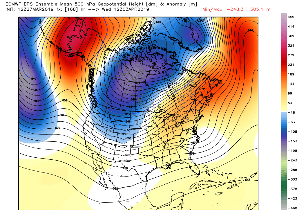
The control run is even colder with that trough.
Can't believe we 1-2'd the big anomalous ridge. First hit was last weekend it moved to Alberta and NW territories, now looks completely dead after a brief resurgance on Monday over interior west.
-
Maybe a little snow on Fri morning to close out the valley winter.
-
Looks pretty bad to me. Boring cloudy weather w/ sprinkles, flooding here and bad skiing. Maybe drops the 850mb temps closer to 0 or below and then it wouldn't be so bad.
-
Well as you know, ULL's still usually mean mostly snow around here through April. I'm just looking for a more active pattern to break these inversions rather than a stagnate pattern that we've been stuck in.
This current pattern has done very little to melt any snow, would love to start seeing some bare ground at some point instead of just sun crusted snow.
There is no pattern that will melt this snow fast. Although Missoula and Mission valleys are pretty close to breaking out out of the inversion after substantial snow melt.
-
Banner end to the ski season here: https://www.weather.gov/bou/MountainSnowfallMarch2019
Ski season doesn't end until June/July depending on where you live.
-
155 block returns. I'm not sure if that's what either of us want at this point.
I'd love to see cutoff season begin right about now rather than another big blocking episode.
Are you looking to cement that 3' snow depth in town? First ULL is on the house this weekend, 5000' snow levels forecast by MSO NWS(guaranteed accumulating snow in downtown Bozeman, one way or another).
-
Such anger...
It’s a solar minimum guys. Act like it!
Seasonal anger lag
-
Missoula has not hit 50 degrees since November 4th. Definitely a winter without an unseasonal warm up. 50 Should fall today or tomorrow however. This also might be some kind of a record.
-
 1
1
-
-
Downslope warming on steroids.
Wrong side of the mountains...
Definitely a very surprising way to score it, 0 expectations and build-up to it.
-
What a weird way to score hottest March SEA day. The ridge is not even that strong???
-
Not quite yet... there is still some snow in the shaded areas. But it was only 66 today.
Only 50's here. We don't flip to a surface warm pool like Eastern Washington does. I do wonder if it's possible here in April, I bet some Montana cities can get 70's and deep snow on the ground(& flooding)
-
70 & snow yet for Tim?!
-
1
-
-
Tim is not posting because it's snowing at his house again?
-
I am getting that feeling too. It would be much more springy though.
Split flow is an above average pattern... Could even be a sunny one for favorable locales
-
1
-
-
That is not really heading this way yet... and it won't be accumulating snow during the day anyways. Its already warming up and the snow is falling off the trees and there is lots of dripping now.
Not sure where you live relative to NB, but the main axis of the zone would be extended right into NB, eastern part of it is just sliding south a bit but it I think it will correct in an hour or two. I agree you will probably get a little melting, but the zone looks very strong and angry, so it should drive down the snow levels below 500' wherever it parks this afternoon.
-
Still snowing... probably 2 inches now.
Vancouver Island CZ headed your way too. Won't be seeing grass anytime soon Tim!
-
Pasco switched over from zr to sn this morning.
-
850mb temps made it above 1c here today(and they still are), but surface obs don't support the low layer warmth. Crazy for March.
-
To be real, snow DOES melt with temps in the 40's, 30's and even the 20's with these mid March sun angles. I've seen my snow base take a pretty decent hit these last few days with lows around zero and highs in the 20's thanks to said sun.
Seems like a couple of you have some unreasonable snowmelt expectations though.
Yeah hardly above freezing here, all the snow a meter from my house on the sunnyside melted over last week. Coolest part is it looks like sastrugi.
-
That map is also misleading. We can easily have highs in the 50s from October into May. Its no wonder its the most common high.
A place like Minnesota is way colder for half the year and then jumps to really warm for 4 months or so.
They might have 70s as the most common high... but 20s might be second most common. They have a wide range... we have a much more narrow range.
We are the bland mild salsa most of the time.

Phil's map is a meme chart. It also shows that the east coast sucks for weather.
-
3.5 weeks of well below normal temps but without a single over running snowfall.
February sun angles.
-
Nice day, 54 degrees. Fired up the smoker and threw some ribs on, homemade mac and cheese next!!
I grilled a couple times(charcoal) in near 0 temps. Wasn't even type 2 fun!
Planning to grill tonight again, should be more reasonable with temps near freezing.
-
1
-

March 2019 Weather Discussion in the PNW
in West of the Rockies
Posted
these 200%+ are all 4-4.5k'. No high elevation sites east of the crest... Except for two Wallowas sites at 7.5k but they are not representative(east slopes in the shadow). I mean maybe this is a case of correlation doesn't equal causation(and NRCS does actual aerial surveys, not just snotel data), but snowpack would be average by april 15th when these mid elevation sites melt off.