

Minny_Weather
-
Posts
10527 -
Joined
-
Last visited
-
Days Won
19
Posts posted by Minny_Weather
-
-
I'm just gonna ride the NAM since that's the one model that still absolutely drills me.
-
 2
2
-
-
6 minutes ago, hawkstwelve said:
00z CMC continuing with a fairly clear southward trend over the past few runs. Not as good for our MN folks but better for me and CentralNeb's areas. Pivotal weather maps actually show a spot with 22 inches within my county, just a smidge off to my NW.

That's... Actually terrible for me. I'd like to not have to settle for 8" in late March.
-
1
-
-
I'm driving home from a hockey game in Fargo right now, and the snow has started way earlier than expected. I'm currently just passed Fergus Falls and it's actually pretty moderate. 24°F.
-
4
-
-
2 minutes ago, hawkstwelve said:
Some models moved the rain/snow line slightly north, others moved it enough south where I am within a stones throw of being on the snowy side. Nothing like living on the edge.
It seems like that's the position I've been in for nearly every storm since 2016, and most of the time it didn't end up working out. Whether it be on the wrong side of a sharp cutoff or on the rainy side of a rain/snow line.
I'm selfishly glad that I've been sitting pretty for most of the model runs on this storm.
-
1
-
-
NAM is getting even more juiced, I end up with 16" at the end.
-
1
-
-
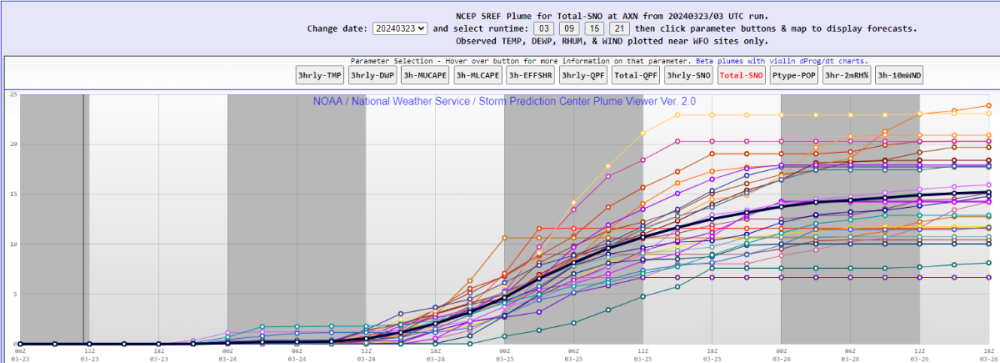 Liking the look of the SREF plume. It's lacking the couple of wacky ceiling outliers that we usually see from this, but the mean for here is still 14.5".
-
3
-
-
1 hour ago, Tom said:
This should be a nice base for the Big Dog that is forthcoming
I'd call it more of an appetizer than a base. I expect much of this to be gone by the end of the day.
-
1
-
-
My eyeball guess is about 3". About what I expected from this, so can't say I'm disappointed. At least it looks like winter, which I wasn't able to say much during actual winter.
I expect a lot of it to be gone after today with highs near the freezing mark and partial sun. 21°F.
-
2
-
 1
1
-
-
Radar returns were definitely better than modeled for the first couple of hours of the storm. I think they downplayed the width of the heavy band and that translated into 1"/hr rates.
Now, returns are about in line with what was modeled. Still, can't help but feel like we scored a bonus inch out of this. 3-4" may have just become 4-5". 23°F.
-
3
-
-
1 hour ago, hawkstwelve said:
18z Euro shifted north a decent bit. From 12 inches to 5 inches for Sioux Falls.
It'd be nice to have a middle ground but I feel like I'll be riding the edge of this thing pretty closely. Big time boom/bust potential for here. I'd much rather be in your spot where you either get a lot of snow or a ton of snow.
Guessing the lower max totals are going to continue as well as a result of better sampling.
Edit: I'm stupid and didn't realize this run ends in the middle of the storm.
-
Fat flakes have been coming down for the last 30 or so minutes
-
2
-
-
23 minutes ago, james1976 said:
Pretty incredible. MPX is already calling for "over a foot likely." And TWC has 18-24" nudging into the Twin Cities.
And tonight I'm in an advisory for 3-6"
A slight shift North would be nice. I'm not sure I want to settle for less than a foot in late March.
But yeah, this is set to be amazing.
-
1
-
-
50 minutes ago, Tom said:
15-20"+ for a large swath of the Upper MW is looking highly likely accomanied with strong winds...Blitz in the works! Knocking on your doorstep bud...and for @Minny_Weather
Dangerously close to not being good for me, though. Definitely need to see a slight tick North.
Euro is great for me. I'll take that 14" it gives me and run with it.
-
1
-
-
06Z GFS goes back to being a bit too far south for my liking. Still gives me a foot, but I get the feeling that this thing is going to lose some moisture in future runs once we get samples of it.
-
Quote
URGENT - WINTER WEATHER MESSAGE
National Weather Service Twin Cities/Chanhassen MN
305 PM CDT Wed Mar 20 2024

MNZ041>045-047>053-059>063-068>070-211000-
/O.NEW.KMPX.WW.Y.0008.240322T0000Z-240322T1500Z/
Douglas-Todd-Morrison-Mille Lacs-Kanabec-Stevens-Pope-Stearns-
Benton-Sherburne-Isanti-Chisago-Wright-Hennepin-Anoka-Ramsey-
Washington-Carver-Scott-Dakota-
Including the cities of Alexandria, Long Prairie, Little Falls,
Princeton, Mora, Morris, Glenwood, St Cloud, Sauk Rapids,
Elk River, Cambridge, Center City, Monticello, Minneapolis,
Blaine, St Paul, Stillwater, Chanhassen, Chaska, Victoria,
Shakopee, and Hastings
305 PM CDT Wed Mar 20 2024

...WINTER WEATHER ADVISORY IN EFFECT FROM 7 PM THURSDAY TO 10 AM
CDT FRIDAY...

* WHAT...Snow expected. Total snow accumulations of 3 to 5
  inches.

* WHERE...Portions of central, east central and west central
  Minnesota.

* WHEN...From 7 PM Thursday to 10 AM CDT Friday.

* IMPACTS...Plan on slippery road conditions. The hazardous
  conditions could impact the morning commute.


PRECAUTIONARY/PREPAREDNESS ACTIONS...

Slow down and use caution while traveling.

The latest road conditions for the state you are calling from can
be obtained by calling 5 1 1.
I'm in the same WWA as the Cities. Grid has 3-7".
-
1
-
1
-
-
Yeah... Ptype is now officially an issue.
-
5 hours ago, hawkstwelve said:
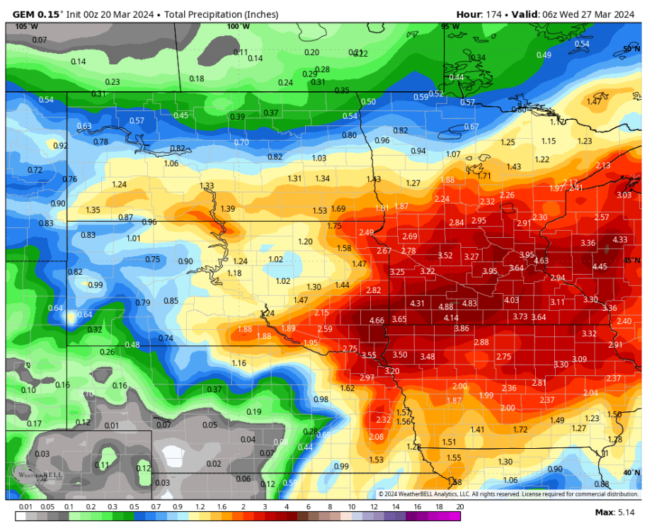
GFS with a pretty large shift north vs 18z with the placement of the secondary low. CMC a lesser shift north but still a shift, and still going crazy with totals. The total QPF it's showing is... Wow. It's enough for more than March and April's average precip combined. Even the other models have shown lesser but still appreciable numbers in the 2-4 inch range.
This storm could end up packing quite a punch wherever it ends up.
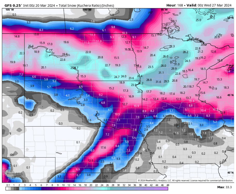
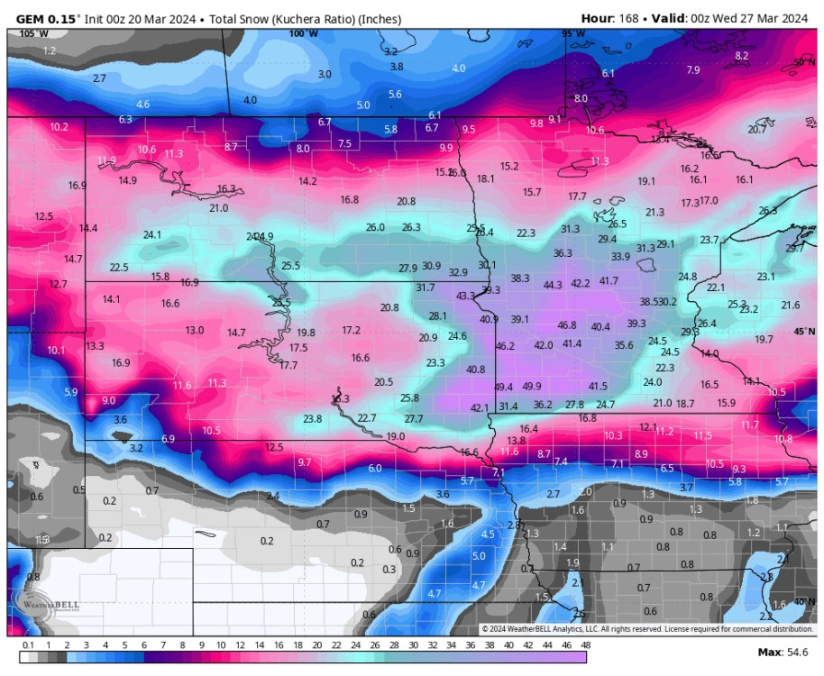
44.3" over my house on GEM

-
1
-
-
I think NAM's "widespread 4", isolated 5"" solution is a bit more realistic for the Thursday night wave than the WSW-level stuff that the globals have been spitting out.
-
18 minutes ago, hawkstwelve said:
EPS is moving in the wrong direction for here.

It does suck that it's impossible for both you and I to get good snow accumulations it seems. At least you'll be getting good moisture regardless.
-
1
-
-
The pro/con to living on the edge of 3 different CWAs? 3 different AFDs to look at.
MPX:
QuoteThere is an increasing chance a much more impactful system will affect the Upper Midwest late Saturday night into late Monday or Tuesday. A deep trough over the West Coast with an incredible 150-175 kt upper jet rounding the base of that trough will come ashore the northern Baja and Arizona Saturday night. A deep, strong low level southerly flow will transport 0.75-1.0 inch pwats northward to Iowa by Sunday. Broad upper lift will result in widespread precip development well north of the surface system (at this point in southeastern Colorado). The forecast area being at the nose of a 50+ kt LLJ Sunday would position us in the crosshairs for heavy precipitation. Cold easterly surface flow should keep it frozen at least through Sunday night. Several inches of snow (6-12+) are quite likely should this evolve as currently being portrayed by early Monday. Model consistency drops off quite a bit early next week with how quickly the surface low lifts north across the region. Ensemble spread is very large. The slower solutions are the heavier ones, as one would expect. Lateral track differences are also evident, with some solutions bringing the surface low into MN and transitioning precip to steady rain or a rain/snow mix Monday and Tuesday. Others keep it east over WI and continue to hammer us with heavy snow. It`s just too early to tell which is more likely at this point and it will take a few more days to nail this down with any great confidence. However, after the benign winter and how dry it`s been (MSP is now experiencing their second longest stretch ever with less than 0.01"), this system could bring major impacts to the region for a prolonged period.
FGF is pessimistic, but a significant chunk of their CWA encompasses areas that were never gonna get hit hard by this storm:
QuoteNearly all ensemble guidance continues to bring a significant late winter system into the Northern Plains and Upper Midwest Sunday into Monday. This lends confidence likely impacts from this system. However, there remains notable uncertainty in location, timing, and coverage of impacts. Should the system move into the Plains weaker with a less amplified trough/ridge wave pattern, most precipitation would favor a track from South Dakota into central Minnesota, largely bypassing our area resulting in lowered impacts from gusty winds acting upon recently received snow from Thursday, which may still result in blowing and drifting snow impacts. Should the system move into the Plains stronger with a more amplified trough/ridge wave pattern, precipitation mostly in the form of snow would envelop a large portion of our area. This would result in high impacts from accumulating snowfall over 6 inches and gusty winds producing blowing and drifting snow. In fact, this scenario holds a 50% chance in exceeding 12 inches of snowfall in portions of southeast North Dakota into Minnesota. With this second scenario still plausible, there remains around a 40% chance of warning- type impacts from heavy snow and blowing/drifting snow. There still remains notable uncertainty in location, timing, and coverage of impacts.
ABR:
QuoteThere appears to be a break with snowfall Friday through Friday night before the next storm system moves into the region for the weekend. There is reasonable agreement among models with the evolution of a Spring snowstorm impacting much of the region this weekend and perhaps into early next week. The storm system may begin on Saturday with light, accumulation snowfall, with more intense rates Saturday night through Sunday night. There is a slight nudge southward with the heaviest pcpn, now mostly in southern ND and across much of South Dakota. While snowfall amounts are unknown, there is a potential for significant, heavy snowfall, with the grand ensemble showing a 5 to 15 percent chance of 10 inches or more of snow in a 24 hour period, ending at 6Z Monday. Precipitation may continue through Monday, with a gradual diminish from west to east Monday night throug Tuesday.
-
1
-
-
23 minutes ago, sholomar said:
KELOLAND being more optimistic regarding getting both waves in the last hour... a "disruptive" storm.. more for Brookings to Sisseton and east into Central MN. More moisture in general is good for this area regardless how it falls.
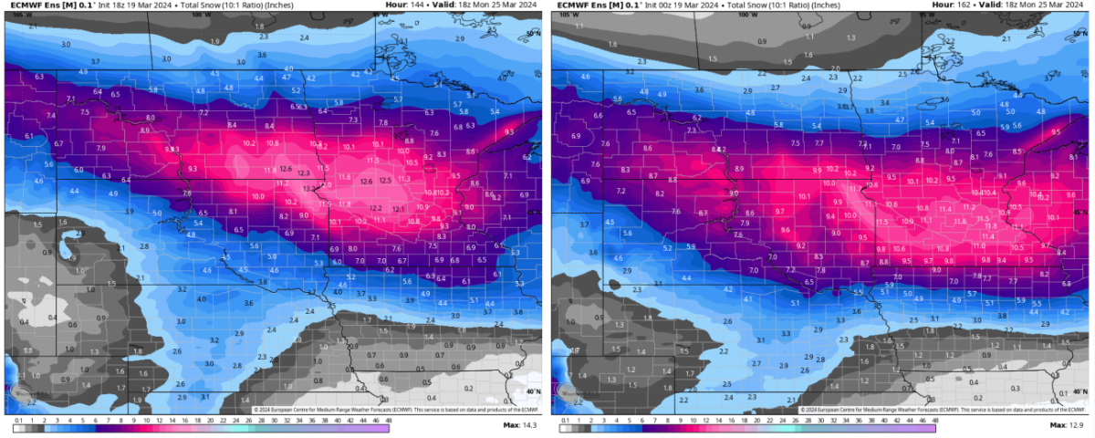
Mirrors op Euro almost exactly. This would be the most memorable storm I've ever been in, and it wouldn't even be close (Feb 2019 in Nebraska is currently 1st), if this came to life.
-
Okay that explains it... On Euro, snow begins falling on Sunday morning at midnight and doesn't stop until 7am Wednesday morning lol
-
1
-
-
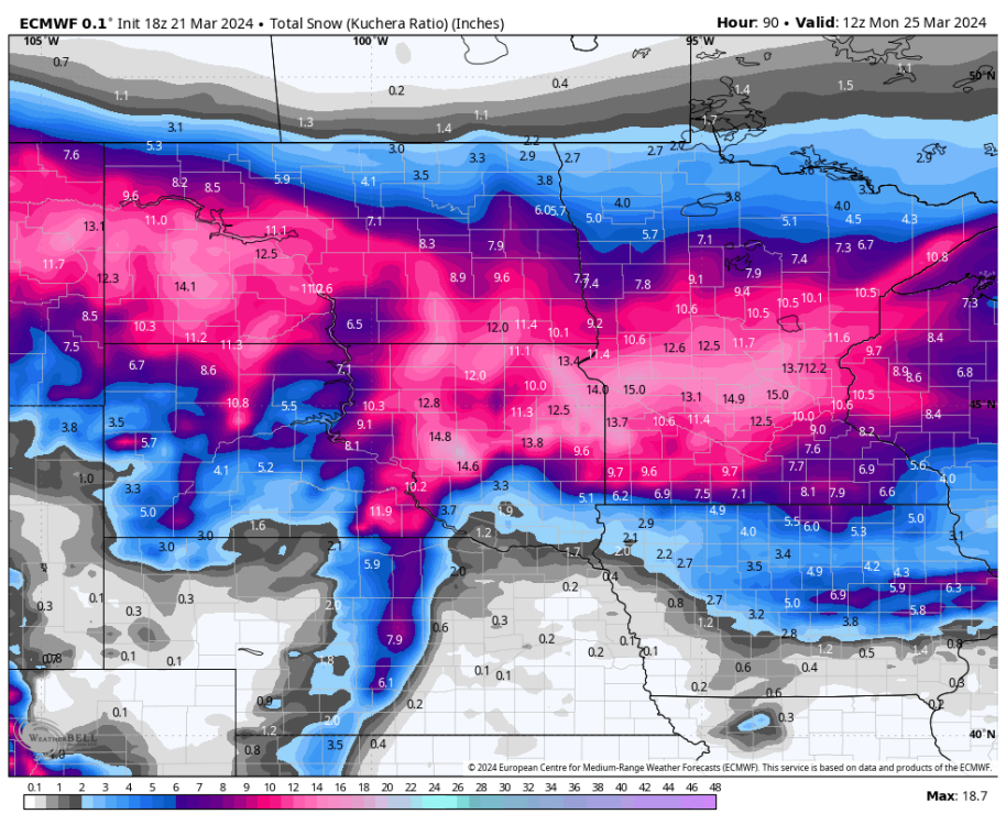
38 minutes ago, bud2380 said:
Euro

Yeah I love that 33" total over me!
-
1
-
-
My biggest concern, of course, remains a south trend. That would rob me of some much-needed precip, while a north trend, I believe, would make everyone pretty happy.
Honestly, if I receive fewer than 10" between the 2 storms, I might consider this a bust.


3/24-3/27 Midwest/Plains Colorado Low(s)
in East of the Rockies
Posted
12 hours into the 12Z HRRR run so far and I'm not a fan of it. Not one bit. Keeps the moisture all down towards the rain/snow line and keeps the snow up here light.
Unfortunately, current radar made me worried that that would happen before this run even began.