


Money
-
Posts
9329 -
Joined
-
Last visited
-
Days Won
11
Posts posted by Money
-
-
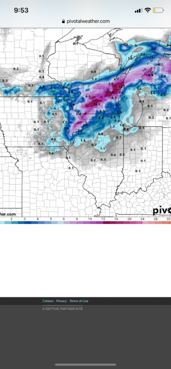
We probably had like 7-8 here
-
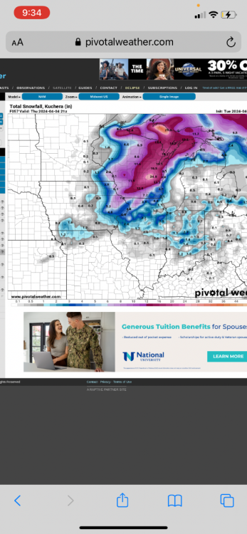
NAM doubled the snow amounts from last run
-
Winter storm warning tonight for 4-8 with storm totals of 8-14 by Wednesday night
Should be interesting
-
 2
2
-
-
Winter Storm Watch for Green Bay Area for 6-12 inches and 50 mph Winds
WIZ013-020>022-031-037>040-045-048>050-073-074-020400-
/O.NEW.KGRB.WS.A.0005.240402T1800Z-240403T1800Z/
Northern Marinette County-Menominee-Northern Oconto County-Door-
Shawano-Waupaca-Outagamie-Brown-Kewaunee-Waushara-Winnebago-
Calumet-Manitowoc-Southern Marinette County-Southern Oconto
County-
Including the cities of Waupaca, Brillion, Harmony, Fish Creek,
Loomis, Wautoma, Neenah, Lakewood, Shawano, Kewaunee, Oconto,
Peshtigo, Chilton, Little Suamico, Manitowoc, High Falls
Reservoir, Redgranite, Luxemburg, Middle Inlet, Mountain,
Townsend, Niagara, New London, Porterfield, Crivitz, New
Holstein, Wausaukee, Appleton, Pensaukee, Clintonville, Green
Bay, Neopit, Oshkosh, Sobieski, Brookside, Sister Bay, Two
Rivers, Menasha, Sturgeon Bay, and Keshena
234 PM CDT Mon Apr 1 2024

...WINTER STORM WATCH IN EFFECT FROM TUESDAY AFTERNOON THROUGH
WEDNESDAY AFTERNOON...

* WHAT...Heavy snow and strong winds possible. Minor blowing and
  drifting snow.  Total snow accumulations between 6 and 12 inches
  possible. Winds could gust as high as 50 mph.

* WHERE...Portions of central, east central, and northeast Wisconsin.

* WHEN...From Tuesday afternoon through Wednesday afternoon.

* IMPACTS...The strong winds and weight of snow on tree limbs may
  down power lines and could cause sporadic power outages. Travel
  could be very difficult.  Aviation travel may see delays. The
  hazardous conditions could impact the Tuesday evening and
  Wednesday morning
-
1
-
 1
1
-
-
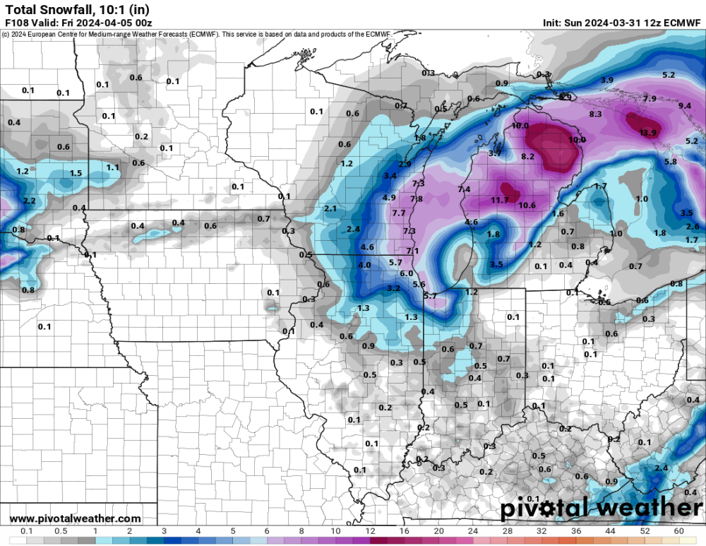
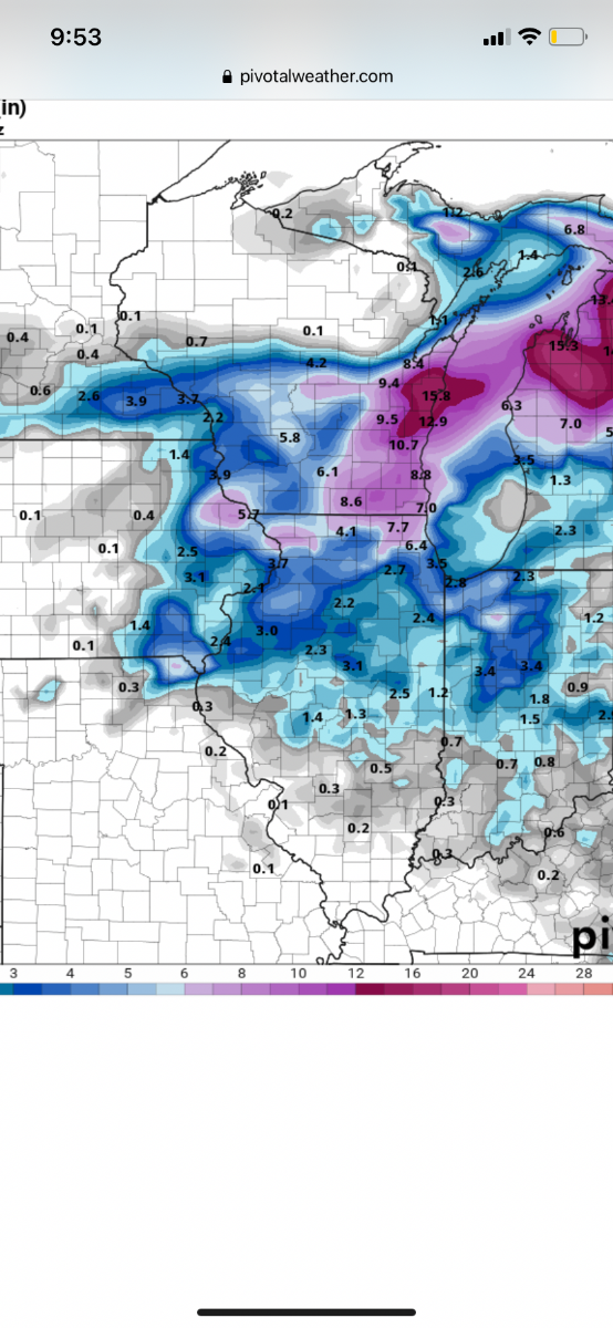
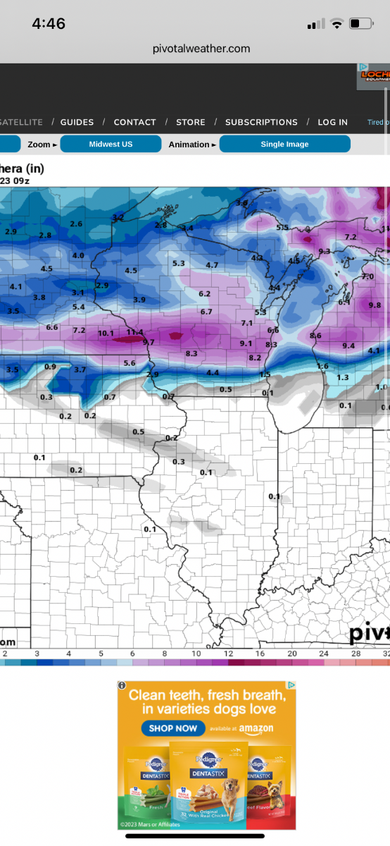
GFS kuchera is insane. Even half of that is 10+ inches of snow here. 10:1 shows nearly 2 1/2 feet
-
GFS/Euro/NAM all further NW with the low and defo band. Very narrow band of heavy snow but cut these totals in half on Kuchera and that’s still 6-8 inch storm for April

-
1
-
-
11 minutes ago, Hoosier said:
What I would probably do at this point is take some kind of a blend between the Kuchera maps and the snow depth maps. Maybe like 70% Kuchera and 30% snow depth. The reason being that the depth maps will tend to be flawed in situations like this with decent rates and marginal temps (depth maps will tend to underestimate).
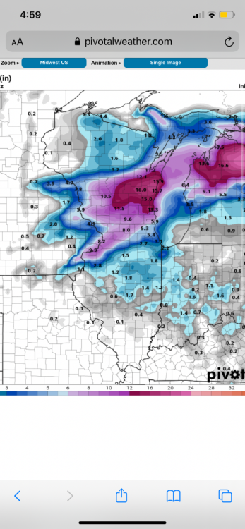
Agreed. It’s crazy looking at 10:1 maps and seeing almost 2 feet in some areas lol
-
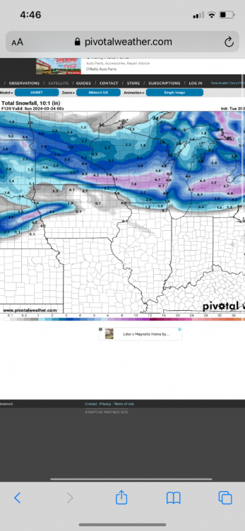
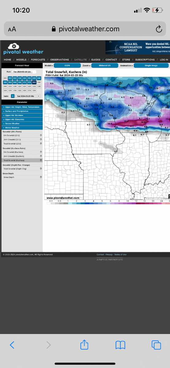
NAM snowfall (still snowing on 3K)

-
1
-
-
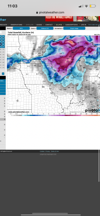
NAM/3K NAM showing 12+ in many areas
-
1
-
-
Green Bay AFD
The main timeframe of concern with this system however, is
Tuesday night through Wednesday. A strong secondary shortwave
will dig into the Upper Plains and western Great Lakes, which may
phase with the current surface low and lead to some
intensification of this system. The first and higher confidence
concern with this system will be wind gusts. Soundings bring
between 40 to 50 knot winds to 850, with fairly favorable
conditions to mix to the surface by Wednesday afternoon. This
would make for widespread gusts around 30 to 40 mph gusts over
land and possibly higher over marine. The second concern would be
a potential increase in precipitation, as the system possibly
retrogrades and brings the higher qpf and dynamics back to the
region. In the worst case, this would support significant
snowfall along the Lake Michigan shoreline and downstream of the
Bay of Green Bay. Delta-T values aren`t that impressive by
themselves (6-10 C or so) but could certainly enhance any
precipitation given the dynamics in this system. This would be the
worst case and only the GFS has this solution for now, so the
current forecast calls for lesser amounts of snow for the time
being. It bears stressing however, that given the winds during
this time period, any snow will cause travel impacts due to low
visibility from blowing and drifting.
-
1
-
-
3 hours ago, Hoosier said:
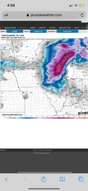
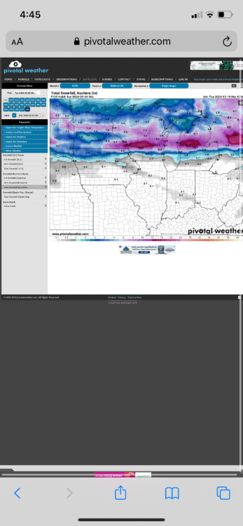
Granted this is 10:1 so have to cut it down by a decent amount, but still not the most welcome sight after all the warm spells we've had.
I kind of gave up on the snow yesterday and now looking at 18z all kuchera outputs showing up to a foot of snow lol
-
Check out the difference in the East coast storm on the icon between 12 and 0z
-
-
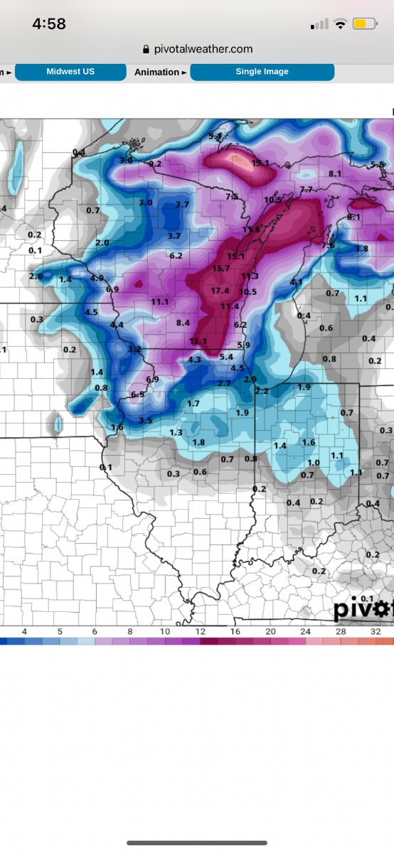
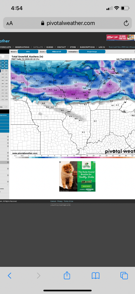
6z GFS shifted a tad south and widened the band a bit with general 6-12
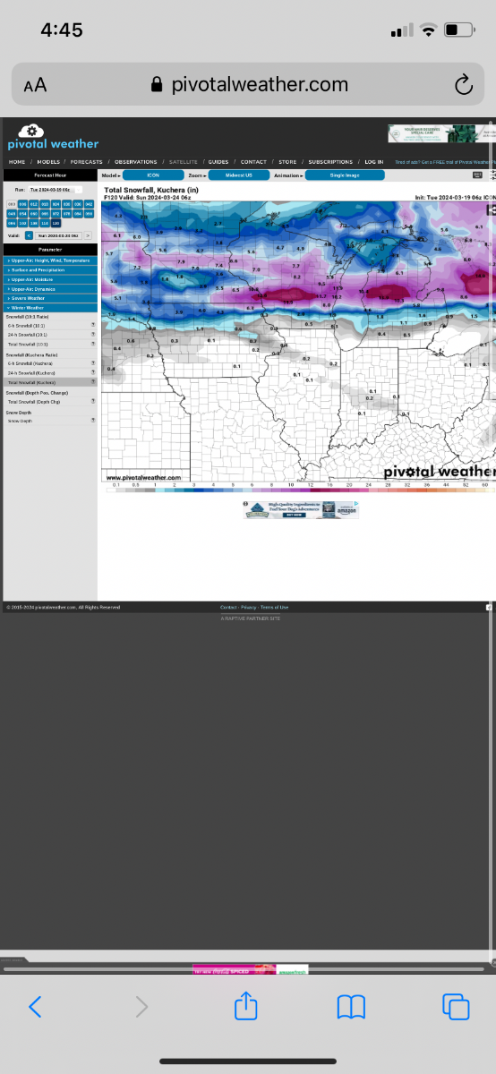
MKE AFD this morning:
Confidence is high (70-90%) in widespread accumulating snowfall
for southern Wisconsin late Thursday through at least Friday
morning, as a shortwave moves through the region. The big
question with this system is the track of the stronger
frontogenetic forcing. Models still vary a bit with the
placement of the strong frontogenesis, ranging from along/just
north of the northern forecast area border to along the WI/IL
state line. Locally higher amounts are expected with the
stronger forcing, but it`s too early to pin down totals,
especially where these higher amounts may wind up. Given that
this system has slowed down a bit, confidence is increasing that
accumulating snowfall will impact the Friday morning commute,
especially where any banded snowfall sets up due to the stronger
forcing.

-
1
-
 1
1
-
-
This is a sneaky potential system for Friday for WI/MN area
ICON/GFS/UKIE

-
2
-
 1
1
-
-
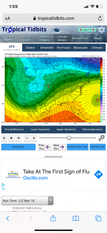
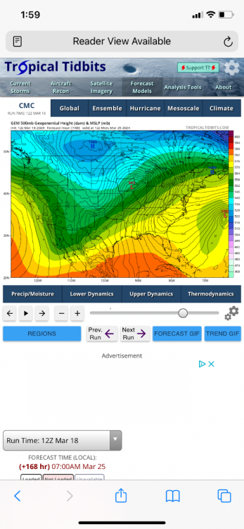
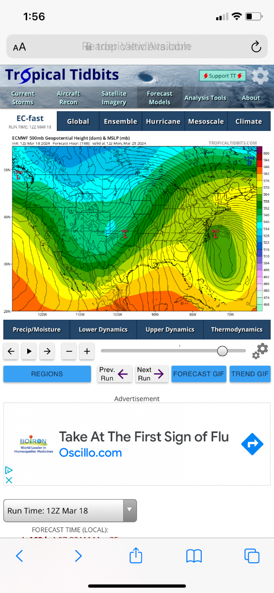
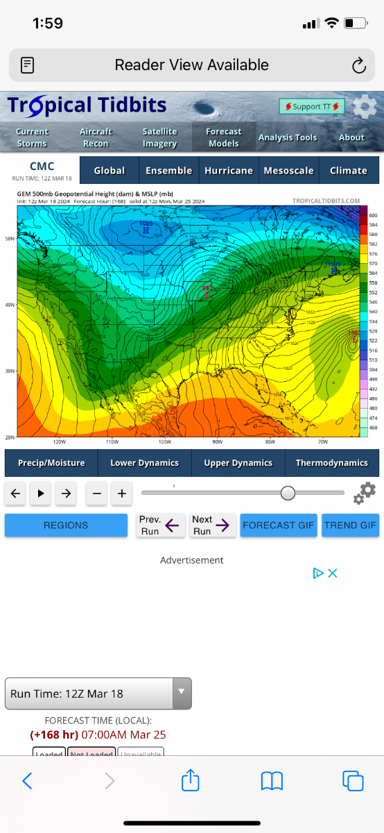
One of the things I have noticed with 12z runs is euro has some sort of tropical storm on the east coast which forces this storm more north? GFS/Euro/CMC at 168

-
3
-
-
Think winter is pretty much done for February
-
1
-
-
We literally had like two snowstorms here and that was it. Kind of crazy
no ice up at the lakes for sturgeon spearing this year
-
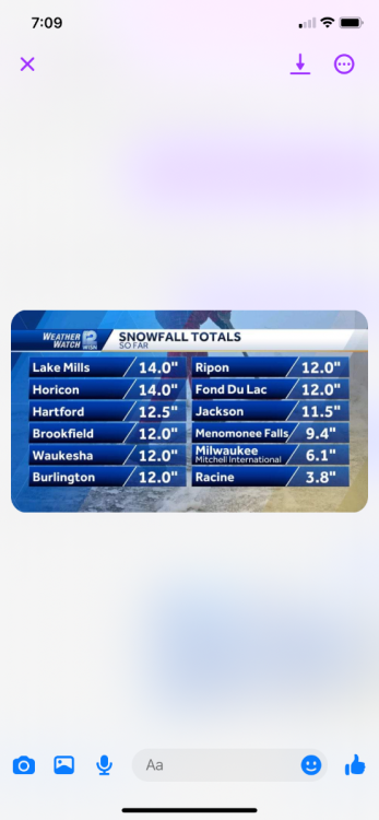
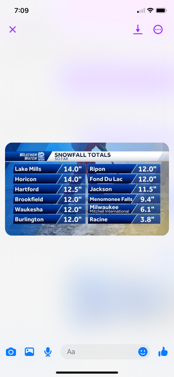
Snow totals in S WI
-
2
-
 1
1
-
-
This video is insane
https://x.com/Tom_Wachs/status/1746022391224861067?s=20
sums up the storm here. Reports of 15” just southeast of here
-
 1
1
-
-
Storm definitely over performed here. Already many reports of 10-12+ with several more hours left
-
 1
1
-
-
Everything on track here
reports of 8+ in southern wisconsin with many hours left of snow
-
5
-
-
2 minutes ago, gosaints said:
Not juiced.
For his area it is
-
4 minutes ago, MKEstorm said:
Yeah, the mets are playing it safe with this storm, seeing what occurred near the lake yesterday. This system is much different though. It will be rapidly intensifying, whereas the storm yesterday not as much. There will be much stronger winds and also arctic air coming in behind it! Hopefully all of this can hold off any warm air off the lake. It will be interesting to see what happens.
Playing it safe is fine but using the hrrr 48 hours is stupid. HRRR should only be used within 10-15 hours or less
-
2
-


March 31st - April 2nd Potent Plains Storm
in East of the Rockies
Posted
Right in those areas. I think most of it fell from like 2-6 pm on Tuesday than when rates were lower it had a harder time accumulating