


Money
-
Posts
9329 -
Joined
-
Last visited
-
Days Won
11
Posts posted by Money
-
-
-
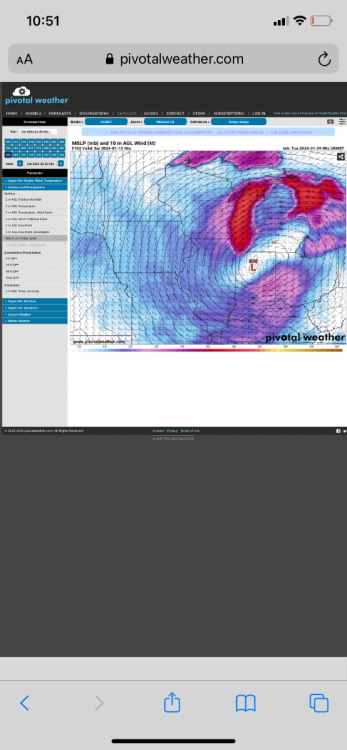
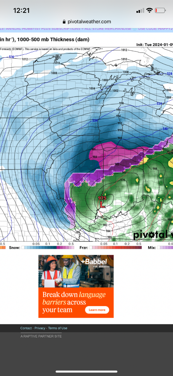
Gets down to 965 in south MI
-
-
-
Euro is gonna be NW than 12z for sure
-
Ukie gets down to 972 pretty much same spot as GFS. Winds look insane on it
-
 1
1
-
-
Ukie is identical to GFS
-
 2
2
-
-
Just now, Hoosier said:
GFS has a bad of 2.5" precip in northwest IN... unreal. Imagine that with even slightly better ratios thsn modeled.
Looks like some good LE potential along Wisconsin and Illinois?
-
-
-
Pretty similar overall
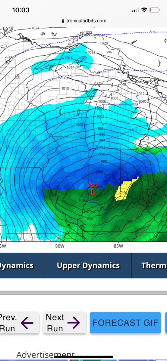
gets down to 974 in east central IL
-
1
-
-
Early guess is gfs comes in just a tad East of 18z but west of 12z
-
1
-
-
-
Icon looks like it will be coming west of its previous runs
-
1
-
-
-
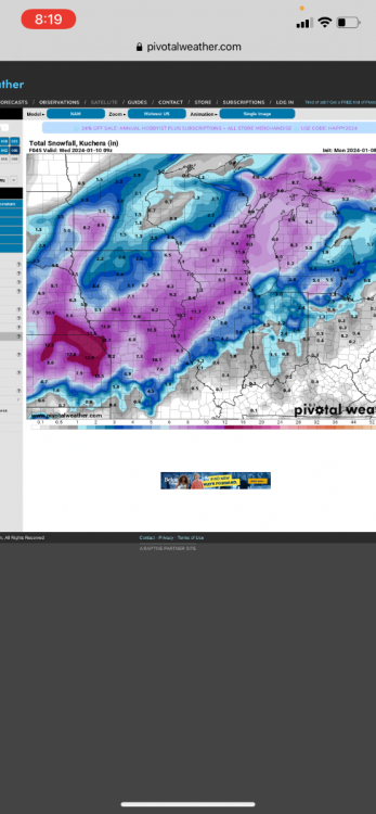
Milwaukee going with 9-14. Seems high
National Weather Service Milwaukee/Sullivan WI
209 PM CST Mon Jan 8 2024

WIZ046-047-051-052-056>059-062>064-067>069-090415-
/O.CON.KMKX.WS.W.0001.240109T1200Z-240110T0900Z/
/O.CON.KMKX.WW.Y.0001.240109T0300Z-240109T1200Z/
Marquette-Green Lake-Fond du Lac-Sheboygan-Sauk-Columbia-Dodge-
Washington-Iowa-Dane-Jefferson-Lafayette-Green-Rock-
Including the cities of Montello, Westfield, Oxford, Neshkoro,
Endeavor, Berlin, Princeton, Markesan, Fond Du Lac, Plymouth,
Sheboygan Falls, Howards Grove, Oostburg, Baraboo, Reedsburg,
Prairie Du Sac, Sauk City, Portage, Columbus, Lake Wisconsin,
Lodi, Beaver Dam, Waupun, Mayville, West Bend, Germantown,
Hartford, Dodgeville, Mineral Point, Barneveld, Madison,
Watertown, Fort Atkinson, Jefferson, Darlington, Shullsburg,
Benton, Belmont, Argyle, Blanchardville, Monroe, Brodhead,
Janesville, and Beloit
209 PM CST Mon Jan 8 2024

...WINTER WEATHER ADVISORY REMAINS IN EFFECT FROM 9 PM THIS
EVENING TO 6 AM CST TUESDAY...
...WINTER STORM WARNING REMAINS IN EFFECT FROM 6 AM TUESDAY TO
3 AM CST WEDNESDAY...

* WHAT...For the Winter Weather Advisory, snow expected. Snow
  accumulations of 1 to 3 inches. For the Winter Storm Warning,
  heavy snow expected. Additional snow accumulations of 8 to 11
  inches for a storm total of 9 to 14 inches. Winds gusting as
  high as 35 mph.
-
Euro gonna be east of 0z IMO
-
Euro increases totals in Iowa
-
-
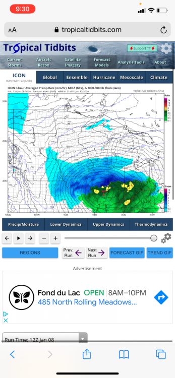
GFS bombs away
973 in western IN at hr 102
-
Icon bombing out at that point
-
Looks like Icon is gonna be north from 6z
-
1
-
-
Almost 10 inches..Not bad!
-
1
-
-


January 11-13 Major Winter Storm/Blizzard
in East of the Rockies
Posted
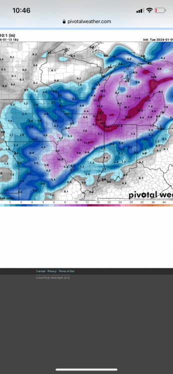
That map is 10:1 ratios as well. Could easily be 12+ in a lot of areas with 30–40 mph gusts