


mlgamer
-
Posts
802 -
Joined
-
Last visited
Posts posted by mlgamer
-
-
23 minutes ago, Iceresistance said:
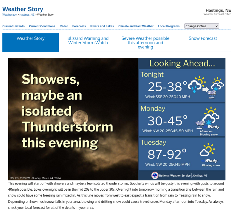
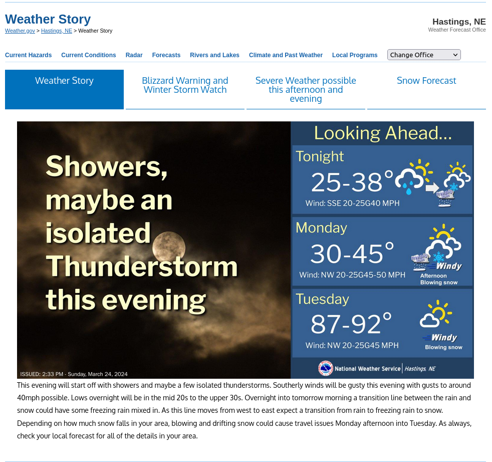
I am sure the 87-92 was a bug and they were trying for 37-52
A bug? How disappointing...I was looking forward to an early taste of summer. [sigh]

-
 1
1
-
-
Not trying to pick on Hastings, but check out their weather story graphic from this afternoon and that big warm up for Tuesday...


-
2
-
-
1 hour ago, Hawkeye said:
The first robin and red-winged blackbird arrived today. Also, I have tulips and crocus emerging.
Noticed our first red-winged blackbird here today as well and same on the flowers! I'm pretty much done with winter and hope it stays away, except we do have that cold shot coming for mid-week. Severe weather season up next.
-
Today's Weather Fun Fact!
My profile says I joined the forum 11/12/2014.
Topeka average annual snowfall for the 10 winters before joining: 21.6"
Topeka average annual snowfall for the 10 winters after joining: 12.8" (*includes this winter so far)
I lost roughly 40% (8.8") of annual average snowfall by joining the forum.

-
 2
2
-
 3
3
-
-
The temp anomaly for December here was +7.0(F) and so far this month sits at -7.7. I expect that will moderate some by the end of the month but an impressive flip nonetheless.
-
1
-
-
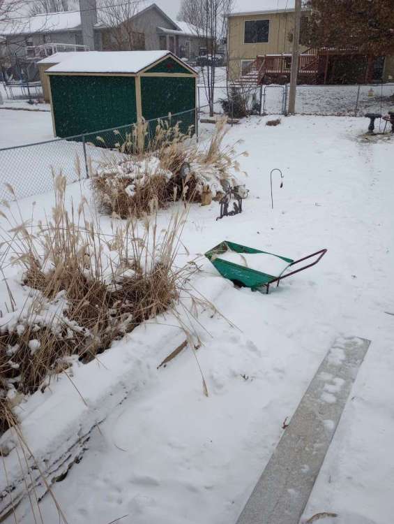
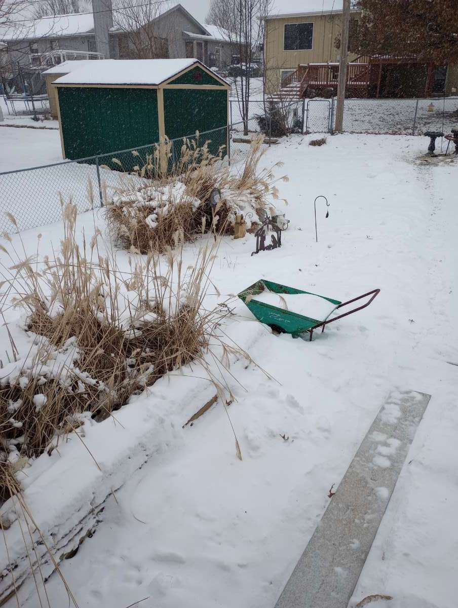
I measured a fresh 1.5" at my house today.
-
6
-
-
28 minutes ago, Clinton said:
I had a nice band of heavy snow move in about an hour ago and it dropped an inch of snow. Moderate snow falling now with a temperature of 3. @mlgamer is right this reminds me a lot of the 80s. Let's keep it going!
Radar still looks pretty good down your way!
-
 2
2
-
-
1 hour ago, KTPmidMO said:
Snow seems a little further south in Kansas than what short term models were predicting? RAP and HRRR saying just to the east of Salina, KS could pick up 4 inches of snow. No big models were picking up on that and RAP and HRRR seem to be reflecting that at the last minute as well. anyone close to these areas?
NWS ICT has put the Salina area and points nearby in a WWA for up to three inches. I have picked up 1/2" in the past three hours and could see making it up to an inch easily. Radar has shown heavier returns generally south of I-70 so higher totals there make sense.
-
4
-
-
1.6(F) in MBY with a gentle snow falling.
As others have noted, it feels like I have time-traveled back to the winters of the late 70s and early 80s. Is it January 1979 or 2024? It seems most everyone in the sub has gotten in on the action and how often does that happen? Enjoy!
-
1
-
 1
1
-
2
-
-
On 9/3/2023 at 10:10 AM, gimmesnow said:
The Old Almanac and Almanac have been doing long range forecasts for over 200 years. They don't have models and all this other stuff, they do it with completely different tools they keep secret. Both almanacs are saying cold and stormy for most of us. Old Almanac is going all in. I guess we'll see, meteorologists seem to think winter won't be that good but the Farmers are all over cold and snow.

I remember laughing at this map when it was first posted. Shows how little I know...lol

-
33 minutes ago, The Snowman said:
Radar returns re-intensifying as they rotate down through eastern Nebraska; snowing essentially sideways at this point, really pretty to watch
Pockets of brief moderate to heavy snow have even rotated down to me in northeast KS. Makes a nice snowy scene with a fresh dusting to an inch on top of our previous snow.
-
2
-
-
9 minutes ago, sumweatherdude said:
I think it's appropriate that this looks like a giant phallus giving it to KC. That's what usually happens. I am, however, enjoying the posts from Iowa every 5 minutes telling us how good it's looking for them. It's amazing how many different ways one person can say the same thing.
I gotta admit...I laughed way harder and longer than I should have when I read this. I had just posted mine in the complaint thread.
-
1
-
-
Back to the usual in my neck of the woods...
-
1
-
 2
2
-
-
26 minutes ago, KTPmidMO said:
Yeah I haven't had a good feeling about this storm for central Missouri for a couple days now. Maybe I'll get proved wrong but I don't know. I'm more interested in the Monday system. Most models are putting a WIDE area of snow down on Monday and ratios look to be 20:1 or better.
Yeah, I've pretty much written this next one off. The Topeka/I-70 snow dome is taking control again.
-
Looks like I finished with 5-6". Not too bad after getting off to a slow start.
-
5
-
-
This is what I'd call an "active pattern"!
-
4
-
-
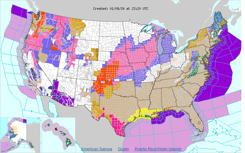
Interesting...civil emergency messages...one in the OK panhandle and one in SW KS.
OKC025-090600-

BULLETIN - EAS ACTIVATION REQUESTED
CIVIL EMERGENCY MESSAGE
CIMARRON COUNTY EMERGENCY MANAGEMENT
RELAYED BY NATIONAL WEATHER SERVICE AMARILLO TX
502 PM CST MON JAN 8 2024

...DANGEROUS TRAVEL CONDITIONS ACROSS CIMARRON COUNTY...

THE FOLLOWING MESSAGE IS TRANSMITTED AT THE REQUEST OF THE
CIMARRON COUNTY EMERGENCY MANAGEMENT.

THE CIMARRON COUNTY EMERGENCY MANAGEMENT IS REQUESTING FOR ALL
CITIZENS IN THE COUNTY TO SHELTER IN PLACE DUE TO DANGEROUS
BLIZZARD CONDITIONS. ALL MAJOR ROADWAYS IN AND OUT OF CIMARRON
COUNTY REMAIN CLOSED. STRANDED MOTORISTS ARE BEING REPORTED ALL
OVER THE COUNTY. IF STRANDED, EMERGENCY VEHICLES MAY NOT BE ABLE
TO REACH YOU DUE TO IMPASSABLE ROADWAYS.

$$
KSC175-090200-

BULLETIN - EAS ACTIVATION REQUESTED
Civil Emergency Message
Kansas EMERGENCY MANAGEMENT AGENCY Dodge City Kansas
Relayed by National Weather Service Dodge City KS
459 PM CST Mon Jan 8 2024

...DANGEROUS TRAVEL CONDITIONS ACROSS SEWARD COUNTY...

The following message is transmitted at the request of the Kansas
EMERGENCY MANAGEMENT AGENCY Dodge City Kansas.

THE SEWARD COUNTY EMERGENCY MANAGEMENT IS REQUESTING FOR ALL
CITIZENS IN THE COUNTY TO SHELTER IN PLACE DUE TO DANGEROUS
BLIZZARD CONDITIONS. ALL MAJOR ROADWAYS IN AND OUT OF SEWARD
COUNTY ARE NOW CLOSED. STRANDED MOTORISTS ARE BEING REPORTED ALL
OVER THE COUNTY. IF STRANDED, EMERGENCY VEHICLES MAY NOT BE ABLE
TO REACH YOU DUE TO IMPASSABLE ROADWAYS.
-
1
-
-
11 minutes ago, Clinton said:
Just saw that thundersnow was being reported west of Wichita, I have 2.5 inches on the ground and I am shocked at how quickly it accumulated on the roads given it was 43 at 8am at my place. Lots of melting going on with warm surface and temps right at freezing. I feel lucky the rain/snow line is only about 40 miles south of my place.
Up to now this has been pretty much of a dud here. It started similar to you where the rain changed to snow and quickly accumulated about an inch even on the roads with a temp of 37. Since then the temp has never been below 35 and only mostly light snow off and on.
Looking at radar makes me think you should do pretty good. Better than here I would bet. Either way enjoy!
-
2
-
-
The latest from here...my county has now been added to the WSW calling for 5-8 inches. I probably have picked up an inch so far but there has been melting with temps above freezing. My current temp is 35.1. So far I have avoided the dry slot but generally only light to moderate snow has been falling recently.
-
2
-
-
21 minutes ago, Jayhawker85 said:
@mlgamer you ready for the upgrade to winter storm warning?
Yeah, I think Wichita added some counties so I think maybe an upgrade could be coming. That dry slot is bothersome but I guess Wichita didn't think it'll be a problem so maybe things are a go!
-
1
-
-
The rain has changed to mostly snow at my house now and the temp is slowly falling and now 36.9. Hopefully it stays snow from now on and we get the party started but who knows...
-
oops...wrong thread.
-
Temp has been holding at 37.6 at my house this morning with rain at times. Radar suggests a transition to snow could be occurring soon but still rain here. Just hope the dynamic cooling kicks in and keeping an eye on the dry slot for now.
Looks like lots of folks on the sub are going to cash in on this one, so good luck to everyone!
-
2
-
-
7 minutes ago, Clinton said:
Better than my 1-2 . Garys forecast looks better for ya. Good luck it still wouldn't surprise me if you end up doing well out of this.
That's a pretty conservative forecast it seems, especially up north. The 18z ICON did come back south enough to give me 7.1" (12z 2.3") so maybe that's the start of the trend back south we've been looking for...lol! And maybe we'll come out better with the late week system if this one flops...lol.
-
1
-

March 2024 Observations and Discussion
in East of the Rockies
Posted
For sure...they probably wouldn't mind an early taste of summer themselves right about now...lol