


Esquimalt
-
Posts
2179 -
Joined
-
Last visited
Posts posted by Esquimalt
-
-
1 minute ago, ShawniganLake said:
We have a mole.
 . Little chance that first system does much of anything north of Bellingham
I'm thinking even if the precipitation shield extends towards the duncan area as I think it might, it will not be heavy enough to overcome the dry air.
-
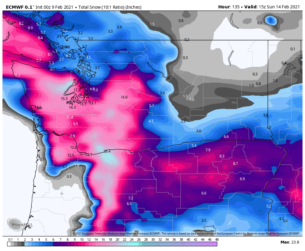
How is the total snow looking after the snow is done?
-
1 minute ago, Kolk1604 said:
I don't think weathermodels has the 6z/18z for the EPS, but have you guys seen the control? Over 16 inches by Saturday with temps in the 20s.
What's it like for southern vancouver island?
-
UKMET coming in SOUTH
-
 4
4
-
 2
2
-
-
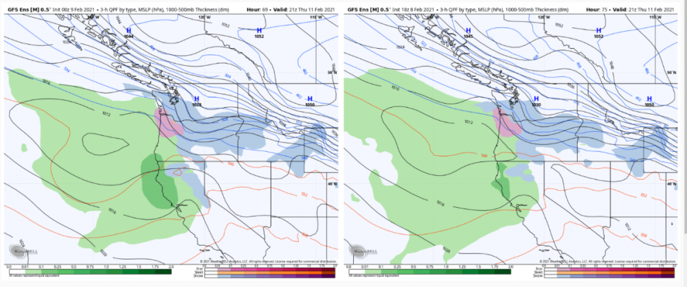
Gfs showing a Monday snowstorm now for Seattle and north. Appears quite marginal thou
-
Just now, MR.SNOWMIZER said:
This has a Vancouver island landfall all over it. Just looks fake watching the low suddenly steer SE.
Just yesteday you were saying a Salem landfall lol. I think a southern Washington landfall is the most realistsc
-
1
-
-
Just now, ShawniganLake said:
Light snow with the first one. Big time over running event to follow
Have you seen the RGEM this morning. Develops a surface low off the top of Vancouver island, showing 10-15 cm over the south island on Thursday evening. Looks like the snow doesn’t stop before the new system comes in
-
1 minute ago, ShawniganLake said:
A small notch north.
Yeah looked bigger at first. I’m thinking our big chance here is on Friday night Saturday morning
-
 2
2
-
-
12z gfs coming in way north. Oh yeah!
-
1
-
 1
1
-
 1
1
-
1
-
-
What did the 6Z eps snow map look like?
-
1
-
-
4 minutes ago, hawkstwelve said:
00z EPS snowfall mean through Saturday morning is less than both the 18z and 12z runs but still respectable.
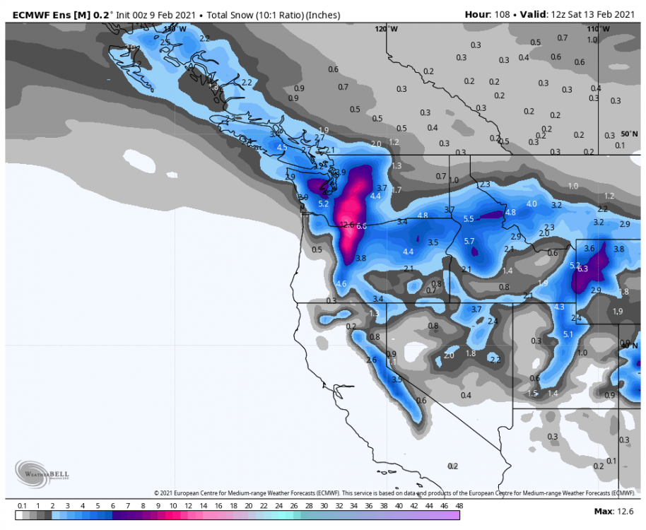
Too warm or drier does it look like?
-
3 minutes ago, SouthHillFrosty said:
This reminds me of February 2017 so much

That is a totally different pattern. Look at that river of moisture coming from the south west
-
3 minutes ago, hawkstwelve said:
By Sunday morning, the wealth has been spread to many.
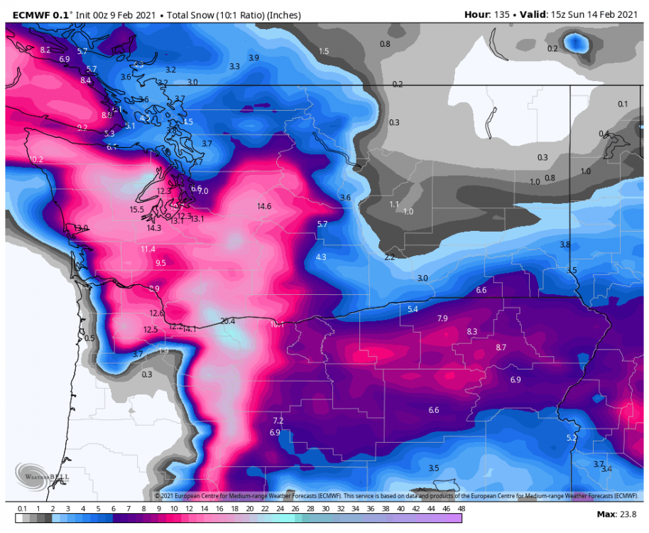
What does the kuchera look like?
-
1 minute ago, nwsnow said:
Ok UKMET we get it...
Keeps going

Why do the totals stop increasing in Victoria? Too warm or the system is too south?
-
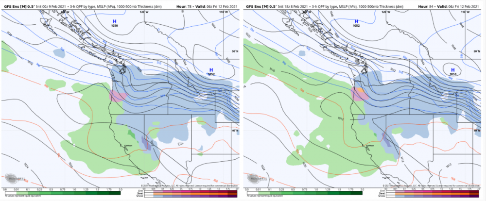
GEM goes way north with the second low. So different.
-
1
-
1
-
-
Just now, RentonHillTC said:
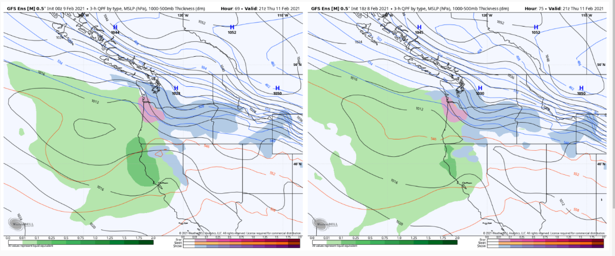
GEFS pretty similar to mid-thursday. Then shows broader snow and less sleet/ice for PDX a few hours later.
Precip shield much further north tonight. Good news.
-
5
-
-
Just now, BLI snowman said:
You seemed to get a lot of snow with the event last year. Of course that was a biproduct of the airmass stalling and missing 85% of us.
Yes. Just saying the euro or the gem run seems much better for evyerone. I would love to see Oregon folks and BC folks score and that's what the euro was showing earlier.
-
1
-
 1
1
-
-
Just now, Kolk1604 said:
Could be wrong but it looks like it brings down more arctic air as it passes to our south
I really don't care about arctic air. Just care about huge snowfalls. This dry pattern is really not doing it for me lol.
-
4
-
1
-
-
Icon goes really weird later in the run
-
1
-
-
It’ll trend north
-
2
-
1
-
1
-
1
-
 4
4
-
1
-
-
3 minutes ago, VancouverIslandSouth said:
Looks similar here, just a trade of dry snow covering the roofs and some other surfaces. Currently 34F with a 27F dewpoint and surprisingly still completely windless.
What are you thinking for this week coming up here in Victoria?
-
Sorry everyone. The RGEM is a bit south of the 6Z run. Still looks a bit mild for PDx but the gorge might help.
-
1
-
-
ICON looking like the euro this morning and 12Z RGEM looks to be coming in further north even than the 06Z
-
 1
1
-
1
-
-
And the NAM is way north. At this rate it’ll be a port hardy snowstorm


February 2021 PacNW Weather Discussion
in West of the Rockies
Posted
Sometimes off the northern tip of vancouver island too.