


weatherfan2012
-
Posts
1478 -
Joined
-
Last visited
-
Days Won
1
Posts posted by weatherfan2012
-
-
6 hours ago, Phil said:
We’ve had 6 consecutive warmer than average winters. Safe bet to assume this will be #7.
I’ll cope somehow.

The good news is things will likely reverse in a few years as these warm winters tend to come in streaks bunchs so if history is any indacation this streak should be about to break sometime in the next few years perhaps the late 2020s 2030s we see a 1960s late 1970s like progression start to take shape unless something really unusal is really going on.
-
 1
1
-
-
I'm starting to think a El Nino maybe favored in 2023-2024 normally these multiple La ninas tend to last three years or so.if 2023-2024 ends up as a Nino with a possable East qbo coming off a La nina period that winter would have great potential.
-
1
-
-
2 hours ago, Phil said:
Don’t see this too often around here.
Wow impressive.
-
 1
1
-
-
Larry Cosgrove thinks a major east coast event happens between now and mid October.says even if it not sam he thinks something else forums and becomes a big threat impact storm interisting.
-
The models Have been terrible in showing the Alaskan low they have badly missed it all summer I have notice which is interesting to me that they have been missing it so badly.
-
Keep an eye on those storms to the southwest Phil just in case anything pops up Tornado watch in effect for our viewing locations.not a good set up to have in the over night when most are a sleep.Ceternly not our typical case.
-
1
-
-
Larry Cosgrove is concern about an East coast threat or 2 sometime in september or october says Ida is not the maine event for the Eastern seaboard.
-
We have to watch the tropics I feel in september or october pattern looks quite dangerous for a few southeast east coast threats with the big bermuda high it not a pattern set up you would want to see doing peak hurricane season thats for sure.
-
8 hours ago, Tom said:
As promised, albeit late, here are some maps off the recent JMA seasonal that is suggesting an interesting Autumn season for many of us in this Sub Forum. The model has been steadfast on the idea that the 500mb over the CONUS to show weakness across the East and a ridge over the West to kick off the 1st month of met Autumn. It also appears Autumn/Winter will get off to another FAST start way up north in Alaska and N. Canada, likely laying down the foundation off "home brewed" early season cold.
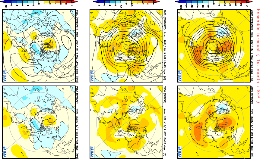
Temp/Precip....Overall, not an overwhelmingly cool or warm signal, except for maybe the central Plains. I could see this warm pocket shift west due to the blocking pattern the model is suggesting. Nice signal for a Greenland Block in the 500mb map above.
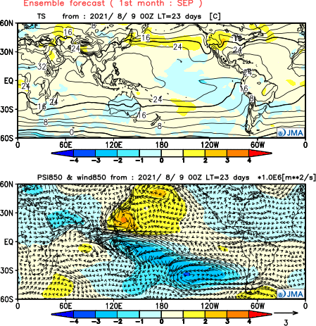
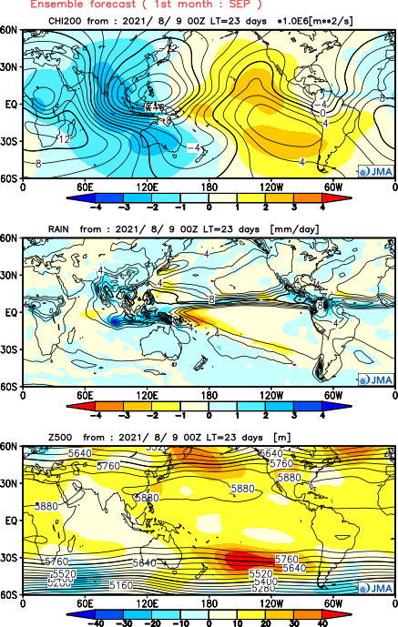
Now, here is where I believe things will get quite interesting as we see a potential glimpse into the new LRC pattern for the Northern Hemisphere. For the second run in a row, the model is suggesting a hyper active W PAC to fire up. Re-curving Typhoons? I think last year and even the year prior it was non-existent. Correct me if I'm wrong, but I think that was a non season. Anyway, look at the rising motion in the month of OCT over E ASIA and the Philippines/Thailand/Australia regions...using this data, one can imagine that the East Asian rule would correlate a trough-like pattern in the east, right???
Well, low and behold, here is the 500mb pattern...Boom! Not to mention, check out the Fierce Greenland Block...that is going to be a common theme for the 2021-22 LRC regime!
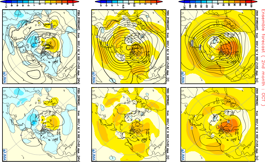
Temp...similar signal as the month of Sept but I do NOT believe it is cold enough...this will prob trend colder during next months run.
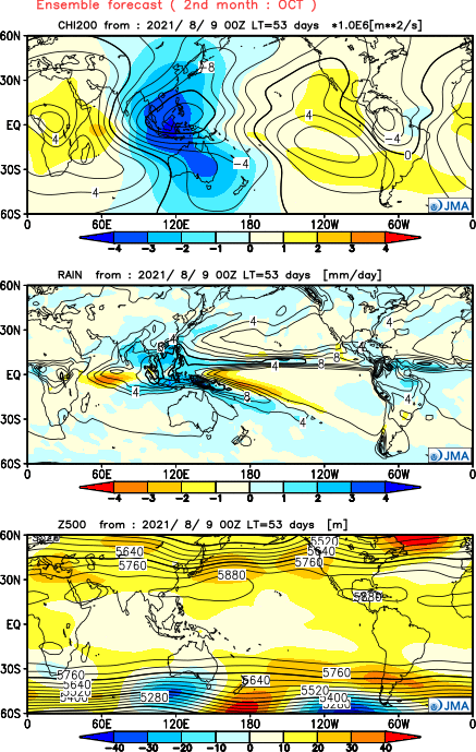
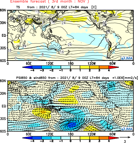
Finally, the month of November just gave me the chills...a continuation of rising motion over the W PAC, W NAMER Ridge (-EPO), slightly -NAO all support a strong signal Winter will come on early for the eastern CONUS.
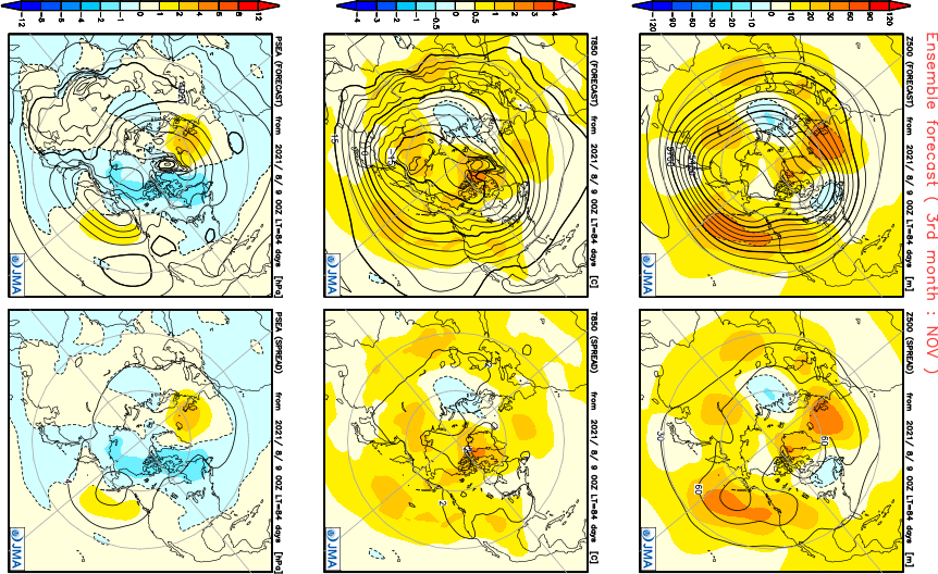
Temp/Precip...you can gauge for yourself that a broad area east of the Rockies is "normal" which I firmly believe the model may be running to warm and should be colder. I'm digging the wet signal in the SW. I'm sure there will be periods of warmth and the month of Oct is when I see periods of this to happen. I just got this funny feeling we will see the jet stream really fire up towards the end of Sep into Oct allowing for storms to cut and allow for warm periods but not overly long lasting. I see many transient warmer periods if this model is correct.
I'm curious if the wet signal out in the SW will be a clue that storms cut underneath the ridge out west. If so, this would be a classic -EPO pattern and during the heart of Winter, you can bet that it will provide a solid winter for those areas, esp with the immense high lat blocking signal the climate models are suggesting. The intense Monsoon season ongoing in the desert SW, IMHO, is a definitive clue to me, that the cold season will be filled with blessings of Snow in the inter-mountain west and SW mountains. Let's see how this all sets up but for the sake of the drought regions in the west, if this wet pattern sets up in Nov, it will bode very well for the western CONUS.
Also, notice the trough signal right over Japan...this is a solid Long Range clue that the east will indeed experience more of a trough than a ridge pattern. So, will the SER ever fire up this season??? Based on what I'm seeing, the general idea is that it could be "muted" this season and possibly stay put over the southern states instead. I, personally, am getting a bit antsy to see how this all evolves and to see what nature has in store for the U.S.
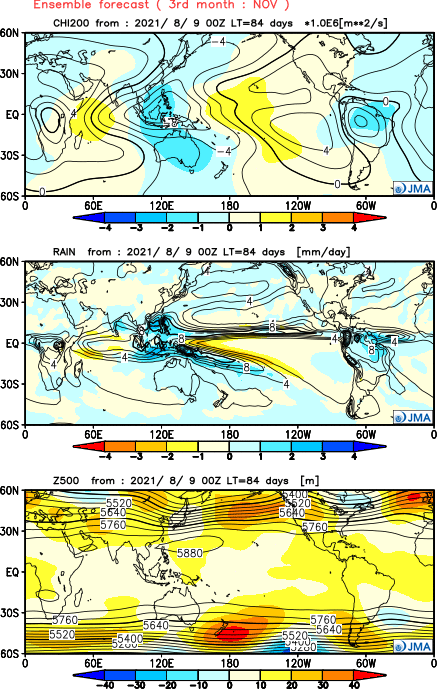
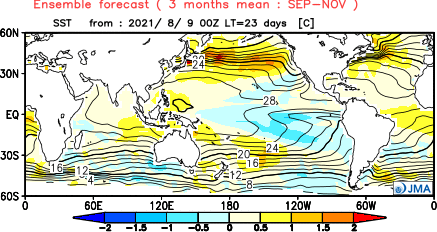
SST 3-month anomaly...
Cosgrove has been hinting to this a bit.he also strongly concern about East coast hurricane threats in september and october.
-
At least next weeks looks somewhat cooler even with rain chances I will take any cooling over this 98 110 heat index degree crap we been having.Its has suck moose balls for sure.
-
More heavy thunderstorms today.
-
Thunderstorms are amazing to watch howard and Baltimore country got hammard but when it went into Anne Arundel it really fell apart just some left over rain thunder and lighting no wind but it was power pack in howard.pa had a big tornado there today as did New Jersey.So the event did varfie just depended where you were which is typical of convective systems. What was not typical was the April may type of setup severe weather event in late July.
-
Watch out potentially later today could be a pretty impressive thunderstorm event across our reagion will be interesting to see how it forms.
-
4 minutes ago, Phil said:
Got blasted by a nasty-arse t-storm tonight. One of the strongest I’ve personally experienced. Everything is busted up.
OT I know, but it was a hell of a birthday gift from ma’ nature. Tomorrow it becomes a migraine.
Yeah I was tracking that one on radar looked nasty down there for a time.
-
1
-
 1
1
-
 1
1
-
-
Pretty good storm looks to be heading to the Dc locations pretty sorty there is a warning out for it in Montgomery County.looks to be intensifying in the last few minutes.
-
Dan posted and stated he talk with Roberts wife and they are going to continue Roberts legacy and keep the site running there going to ditch the covid and other news talk and stick with climate sounds like Dan has a great plan worked out Andie
-
1
-
 1
1
-
-
Could be a bad one coming to pattern looks nasty for some hits
-
1 hour ago, Phil said:
Man, that would be an amazing severe pattern imby, as long as we don’t end up under the ridge.
Though with E-Hem/Indian Ocean MJO/CCKWs next month, that fat, ugly 4-corners/plains ridge is only going to get fatter and uglier. I fear a top-5 hot August is in store for the lower-48. And September is looking progressively worse of late, as well. Even squinting, I don’t see any real hope on the horizon.

Could be a rough go with tropica systems with that pattern as well in september.
-
On 7/17/2021 at 1:34 AM, Link said:
Except unlike Robert Felix he no longer is afraid to mention there is a climate change going on. Just that it's not man made which goes against the narrative of 'Deniers' vs 'Believers'. It throws that entire argument into the ole rubbish bin where it belongs. \
Robert helps (either inadvertently or on purpose) fuels the 'Deniers' vs 'Believers' false debate as he only focuses on cold spots usually some remote mountain nobody's heard of or gives a flying F about. Grand Solar Minimum while also missing some of the necessary data gets into the bigger picture.
You had to read between the lines with Robert of exackly where he was coming from and Andie would agree with me with that.Robert certainly beleaved in climate changes in a nature caused so I would say it was inadvertently and not on purpose.plus alot of the Articles Robert posted were from the fans that gave him the Articles to post.
-
One of those rare july days where temperatures are in the upper 70s after the swamp of yesterday and the past few days today is a great break.While we have had some decent heat this summer it has not been near as exstream or bad as 2007,2010,2011,or 2012 which were beowed terrible hot misable summers.
-
Baltimore Hartford and baltimore countys and Anne arundel have really gotten hammard this afternoon thunderstorms stalled out for a couple hours just dumping on the locations today.lighting has been intense as well,not much here at my location but not to far away where hell broke loose.
-
15 hours ago, Andie said:
I enjoyed the site as I found a lot of global weather information I would never have read.
He also encouraged people to join in and many appreciated the community feeling. If nothing else Robert brought people into the conversation and enjoyed the dialogue.This he also Andie brought a very respectful civilised discussion with no attacks or name calling nor fights which is hard to find on most climate discussions these days.Robert was easy to talk with and deal with.
-
1
-
-
6 hours ago, Phil said:
That’s one heck of a CCKW. Transits the Atlantic then back into the W-IO during the 3rd week of July.
Second IO pulse would follow in early August. If this is accurate, then it’s almost three weeks later/slower than I thought just a month ago. Ugly, ugly miss on my part.

We are not perfect weather forecasts are not anexack science misses can and will happen.the fact you privide updates and weather discussion is way more then you can say to other forums around.
-
1
-
-
1 hour ago, Phil said:
Settling in down here in Saint Simons, GA.
Literally the exact same weather as back home, no discernible difference at all.
Have a good vacation man disregard my post about the lighting yesterday since you our out of town

-
 1
1
-

PNW October 2021, Pumpkin Spice Edition
in West of the Rockies
Posted
In fact in contary to most thoughts the Nina west qbo cases can be good very good winter patterns coast to coast the same with El nino East qbo combinations.