


weatherfan2012
-
Posts
1478 -
Joined
-
Last visited
-
Days Won
1
Posts posted by weatherfan2012
-
-
4 minutes ago, Phil said:
Verbatim that’s a cold pattern here, but I’m sure the flip to spring will be fast and hard, as it is almost every
Once late march April is here some nice spring weather is ok as long as it not blow torching summer temps bad enough we get that in the summer.
-
I can not recall having freezing rain last this long in this reagion.certernly an experience. I also can not recall to many times when the snow was coming from a North and north east direction While we may not be the snow tops with this.I have to say this is one of the more interesting Miller Bs I have seen in this region not only in a forecasting sense but how it all came togeather.
-
Who ever made the call to drop the winter storm warning last night at the nws needs to have there buts kicked.the ice is pretty bad this morning it a sheet of ice every where here bad call from the nws on that.
-
Pattern looking really good going into Febuary lots of potential coming up the ones that went for a Febuary pattern very unlike La nina progressions I serlute them because it looks more and more like a good call.if anything our winter may just be starting lol.
-
 1
1
-
-
59 minutes ago, Phil said:
New NWS forecast is for 24-30” in E-PA/NJ. Jealousy is consuming my psyche.
Not really jealous to be honest we knew this was a Miller B now if this was a Miller A then entirly different story pure jealousy then

-
Things look good in febuary mjo maybe going into phases 8 through 2 over the next few weeks potential big seacond half of winter.
-
Got to give Larry Cosgrove big time props his ideas for Febuary look to be varying nicely heck of a long term call from him back in the fall.
-
8 hours ago, Phil said:
Wind was roaring most of last night. Didn’t get a great night sleep. Diurnal lull from 4-7AM followed by a quick ramp up once again this morning.
In other news, looks like our biggest snowfall of the season so far is in the pipeline for Sunday-Monday. Should be an initial WAA thump (more certain) followed by the more complicated formation of the comma head as the coastal low develops. So it’s more like a miller-B evolution.
Which means we probably have to play with the dryslot to get the best totals. Want to be just above the 700mb low and ride the dryslot without getting in it. Whoever can get the most out of the WAA thump and the comma head will probably score 5-8” of snow. Areas that get dry slotted and/or flip to IP/ZR may end up with 2-4”.
It almost as if mother nature knew that Trump the red is out of office and Biden the blue group is in
-
 1
1
-
-
05-06 is interesting in that febuary produce quite an hefty storm in our reagion after a crap start.theres also some tendceys for La ninas to produce late season specials something to keep an eye on down the road.
-
32 minutes ago, Phil said:
Give it a try. Every potential outcome in this universe has a non-zero probability of occurring.
Larry Cosgrove has been very bullish on February for a long time now it will prove interisting to see if his ideas are right.
-
The jury is still out on thursdays likely won't know the full details until after monday night tuesday event.Larry Cosgrove is still very bullish on February producing.
-
14 hours ago, Phil said:
We are causing climate change. Question is how much? We don’t have the answer to that.
With each new study that increases the degree of Holocene climate variability, the more likely it is climate sensitivity is state dependent. We’re probably responsible for 30-50% of the post WW-II warming, is my guesstimate.
That and how much if any are we controlling is another question up for debate.Of course if you asks Robert Filex his opinion on it he would argure regardless what we do we can never control these climate cycles.I don't think he disagrees so much that we have some effect.but that the idea we control it is where he disagrees.Thing I have wondered is what made Filex take interest in the Ice age cycles to begin with and to write a entire book about it
 .one thing I gotta give to him is he has done exackly where his mouth speaks on he moved to Texas
-
Just for the record Larry has agreement from Justin Berk who is also going with a cold active February into March.
-
Larry Cosgrove is really bullish on late january and Febuary producing.
-
15 hours ago, OKwx2k4 said:
I'm not going to lie, this pattern change is wearing down my patience. Getting tired of waiting, but I'm still holding. Pacific has been stealing the show for a few weeks now. I still believe the BSR is applicable, but then there's that much going on up there, models will struggle.
Not sure how our ongoing SSW ranks on all time list, but it's a really extreme one. Looking longer range the ensembles do show the cold filling in to Canada, so a trend has started. That's positive to see.
I'm Riding the Larry Cosgrove train he has been pretty accurate this far and has always supportive the mid January throught march pattern producing.In fact he is bullish on what he sees for February.
-
-
16 hours ago, Link said:
Thanks for understanding me. Robert Filex though tends to cherry pick cold weather records as much as the hysteria left do on warmth. I feel like he's part of the PSYOP going on between the two which is why he hasn't 'disappeared' unlike those such as WeatherWar101 that used to upload regular videos until 3 years ago now?
True but then again his site is called iceagenow.info for a reason to post cold trends I do find his idea very interesting and I know Geos tends to agree with him to.only time will tell in the end.
-
3 hours ago, Phil said:
Lol, the East often gets screwed in -ENSO SSW events. Usually the pattern that *produces* the SSW favors the East, but once the PV is gone the cold quickly shifts to the west.
The -ENSO SSW events in 2017/18, 2008/09, 1998/99, 1988/89, 1984/85, etc, all favored the west afterwards, with the eastern cold occurring before/during the event.
Only 2005/06 and 2012/13 favored the East, and those were weak -ENSO. Barely met Niña threshold. This is a much stronger event with a more stable low pass signal.
Which is why I'm surpised some of the well respected mets like larry cosgrove and Justin berk are going with cold snowy febuary ideas they could well be right but the history seems to go against there ideas.But only time will tell in the end who and what proves correct.those for our back yards I hope what they are seeing is right and Cosgrove has been pretty good as of late with seasonal outlooks so it will be interesting to see how it plays out.
-
On 12/31/2020 at 7:18 PM, Link said:
Do you think they were much wetter or drier? How much different do you think the inland high deserts like Bend,Prineville or Pendleton were?
A good question well before my time so have to research look it up those it hard to really find much information about weather clear back then as it was before records started being kelp.
-
9 minutes ago, Phil said:
Low was 21.2°F this AM, which is the coldest of the season so far.
Pattern still doesn’t look all that conducive to legitimate cold anomalies in the medium/long range. I originally thought the first 10 days of January would be cold, but as of now it seems the Siberian high descent/+EAMT is going to keep the Pacific jet cranking.
This could still deliver in the snowfall department with somewhat of a southern storm track. However, for the time being, it doesn’t look like there’s much cold to be had on this side of the pole.
Larry Cosgrove is still going with mid January through March.what concerns me and it not just this winter but the last few is no one including the highly respected mets has been very good with winter outlooks as of late.It a concern because at some point the plubic are going to lose there credibity with many of the forecasters on seasonal long range outlooks.I guess the real question is why have winter seasonal outlooks have been off the last few years.
-
https://www.iceagenow.info/surprise-surprise-any-greenland-melting-is-volcanic/ again this is what Robert Filex talks about in his book and has been stating for years.
-
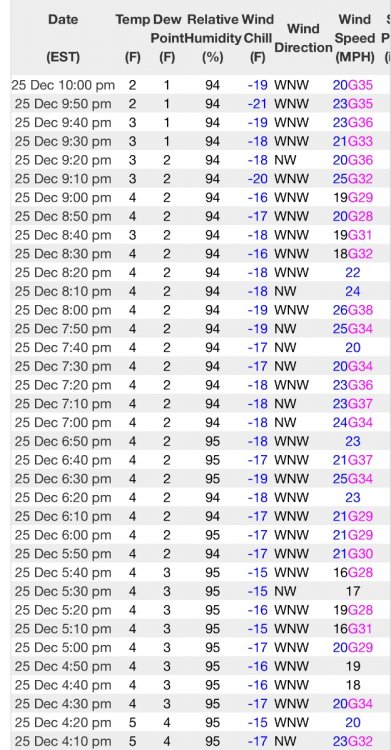
On 12/25/2020 at 10:22 PM, Phil said:
Nippy out there. Temp 24°F, dewpoint 8°F, windchill somewhere around 10°F.
Meanwhile, chills down to -20°F in the mountains:
Dave Tolleris should have never came out with his 96 2010 post a few days ago.it stuff like that that causes the melt downs from people.He needs to wait and see if the pattern is working out before he pulls the hype train.
-
Dt is Spinning he needs to stop hyping storms until he is sure the pattern is set posting in twitter and facebook that the pattern look the best since 96 and 2010 is how bad information gets out in the open.
-
One of the reasons of why Robert Filex states so ofton that the next cycle of the ice age cold phases are due immediately is how long the interglacial cycles last and we are at the point where the interglacial cycle could terminate at any year or time.giving how long this one is now.
2020 Weather Mid Atlantic/Gulf Coast.
in East of the Rockies
Posted
Wow nice surprise for Dc this morning did not quite expect this morning for them.it is nice to see the negative nao back this winter after the positive nao over the last 5 years or more.at least we can say the negative nao is not history after all