NEJeremy
-
Posts
1896 -
Joined
-
Last visited
-
Days Won
9
Everything posted by NEJeremy
-
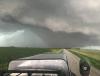
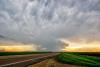
Here's a video of the Louisville tornado when it crossed the Platte River: Also NWS has so far confirmed 6 tornadoes. All were very brief and weak tornadoes it looks like and apparently that picture of the "wedge" wasn't a tornado, just a very low wall cloud. https://www.weather.gov/oax/TornadoSummaryJune2018
-
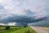
I chased 6/11 in eastern Nebraska. Left Omaha and made my way west of Fremont. A nice cell formed about 5 miles to my west and it was neat to watch it grow from a little cumulus cloud to a severe storm. This storm formed right on the cold front though and I normally don't like storms right on the cold front for tornado potential as the front can undercut them a lot. I watched the storm slowly strengthen and eventually had a precip free base on it's southern end that would occasionally develop a non rotating wall cloud in different spots along the base. I saw the first blips on radar form down by Gretna about 20 miles away and thought that's the storm I am going to go after. It was ahead of the front and by itself. I knew I had some time though as storms wouldn't be moving very fast at all and I was relatively close. Just when I was ready to leave the Fremont storm though it would look a little more interesting with lowerings etc. Finally a much wider base formed and a lowering with an inflow tail started to form. Shortly thereafter a tornado warning was issued. It never looked that great on velocity scans, but definitely looked pretty. Meanwhile the storm near Gretna had really exploded and I started to notice the couplet on the southern end of the storm. I finally pulled myself away from the Fremont storm just as it started to weaken and made my way south. I had to deal with rush hour traffic from the Omaha metro area and heavy rain and by the time I made it down south, the Louisville tornado had lifted. The storm still had clear inflow on it's southern end so I felt I would still try to get around the south side of the storm. A line of storms now formed along the cold front to the west and was catching up pretty rapidly to the cell. I was racing trying to stay ahead of this severe squall line and was able to stop a few times only briefly to try and see into the HP cell. It was tornado warned again and a couple of times I could see a suspicious lowering back in the storm. I eventually made it to Nebraska City about 7p and not wanting to get any further from home I found shelter in a car wash as the storms were warned for 80 mph winds now. The storm passed through town with maybe 50-60 mph winds and I headed home. Looking back, I wish I would have bailed south right away as the Louisville storm produced a brief tornado and had amazing structure, but still was able to see some amazing structure with the Fremont storm which was tornado warned as well, and again saw great structure when I did catch up with the storm near Murray.
-
Ended up with about 1.8" of rain between the two "events" yesterday, a heavy morning tstorm and then the severe weather yesterday afternoon/evening. Didn't have any hail or wind at my place though.
-
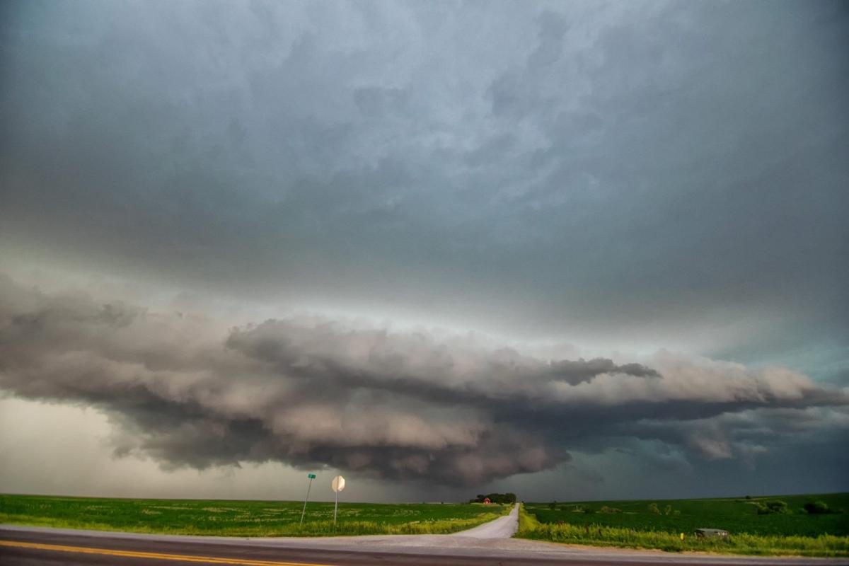
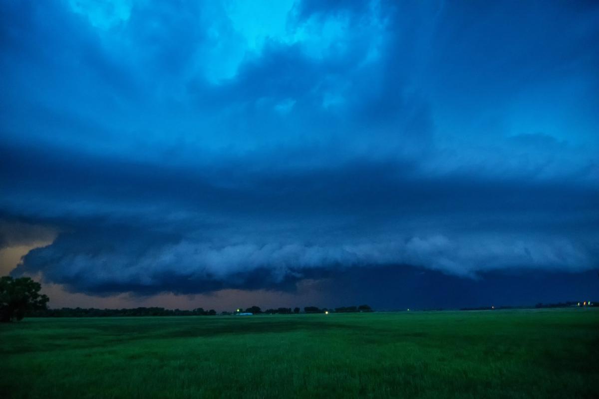
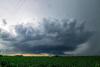
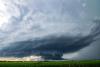
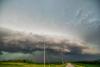
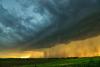
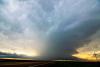
Not my picture, but thought I’d share it. I’ll work on my pics soon. There’s some debate on what this is- wedge tornado or a low wall cloud. No one seems to want to confirm the tornado from what I’ve seen yet. I was on the next major highway south of this so I saw this feature too but from about 4-5 miles further away.
-
I believe that's the true definition of a troll. Something I'm sure he wears with pride and honor.
-
apparently temps were in the low 60s with dews in the 40s when this happened too. Of course it takes a different set of parameters to get tornadoes out there due to elevation, etc.
-
Beast of a storm down in Texas right now: At 417 PM CDT, a severe thunderstorm was located 9 miles east of Cee Vee, or 11 miles south of Childress, moving southeast at 20 mph. This is a very dangerous storm. HAZARD...80 mph wind gusts and softball size hail.
-
Warmest May on record. https://www.washingtonpost.com/news/capital-weather-gang/wp/2018/06/07/the-u-s-just-had-its-warmest-may-in-history-blowing-past-1934-dust-bowl-record/
-
absolutely crazy, beautiful tornado out in Wyoming yesterday. Lasted over an hour too.
-
-
Our NWS office asked for damage pictures and a bunch of people posted that meme on Twitter
-
Sharing a video of the tornado just east of Ord. This was almost exactly my view/experience with this storm in and near Ord. Not the most impressive tornado, but was nice to see one!
-
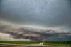
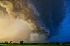
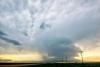
I chased on Friday 6/1 out in central Nebraska. First we went to north central Nebraska where storms were supposed to form first and shortly after arrival near Ainsworth, NE initiation happened about 3p. The idea today was to stay on the tail end of the storms or any discrete storms that could form. We kept dropping south as smaller individual cells would form and either become part of the growing line or would remain pretty weak and not do much. There ended up being a cell near Broken Bow moving northeast that was quite a bit south of the line so every one(there were quite a few chasers out) made a break for that storm. It went severe warned briefly but then weakened. It was about this time where we thought about calling off the chase. Finally though storms began to really strengthen about 7p but were almost immediately forming into a line. We found a field to watch the storms though and the lightning was becoming pretty intense and occasionally there were some areas of rotation showing up within the line as the LLJ ramped up. We had some ping pong ball hail start to fall at our location so we had to bail east out ahead of the line. The lightning was still crazy and there were several strikes that were "out of the blue" way ahead of the storms that seemed to be originating in the anvil of the storm above us. We made it to Ord about 845 and decided to grab a bite to eat before maybe seeing if there would be some decent lightning pic opportunities on the way home. We came back out to our car after stopping at the Casey's in town, and suddenly our phones go off with a tornado warning for Ord! We drove north out of town to try and get a good view and the line of storms now had a pretty pronounced lowering/wall cloud west of town. We took some pics/video and then decided to go back into town and then head southeast out of town on one of the highways. The tornado sirens finally went off in town some 8-10 minutes after the initial warning was issued. I love the eerie sound of hearing the tornado sirens wailing. As we were just getting outside of town, suddenly to the north side of the highway we could see a large area of swirling dust underneath a funnel. A tornado was touching down about a mile away from us! We continued to watch it as we drove on the highway(wish I would have snapped a picture or video), but soon it became wrapped in rain. I wasn't sure if anyone had called it in yet so I called 911 and we continued onto the east to get back out ahead of the line. On the way home, the line of storms turned south and caught us from the north with strong winds and blowing dust. It was pretty cool to look to our north over the fields and when the lightning would flash to our north, you could see all the dust being picked up by the wind.


-
That picture of my patio chairs tipped over was the extent of my damage. I was trying to be funny :P
-
1.37” of rain and plenty of damage at my house.
-
today's highs outperformed the forecast by quite a bit. Forecast was "only" for 90, but we're at 95. Coming into today we were a whopping 8 degrees above normal for the month and we're almost 20 degrees above normal for the high again today. Also almost 3" below normal for rain and last I saw, we're already almost 6" below normal for the year.
-
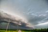
I chased Memorial Day down in Kansas. The original plan when I left the house was to go to eastern Colorado, but on the way there I took a slight detour to check out the storms that were already in north central Kansas by late morning. I figured those would eventually move on and I could continue to the west. However, they kept redeveloping and strengthening and eventually the SPC put out a tornado watch from these storms onto the west into eastern Colorado. Unfortunately for me this day, I had my car and wasn't in my chase partner's truck so that meant trying to avoid the hail at all costs. I ended up being on the east side of the storms in Kansas along I-70 and was basically stuck there as the storms kept developing and forming over the interstate with large hail. I finally had to make a break for it after almost an hour, and made it through the storms unscathed despite some hail. At this point the landspout fest was on in Colorado and I was still an hour away. However, as I at least initially tried to get to Colorado, I met this fast moving left mover that crossed the highway in front of me. One of the cooler looking storms I've ever seen and it even managed to drop golf ball sized hail in front of me. Looking back, I'm glad I had my car on this trip as that night when i was heading home and had to avoid the frickin SEMI that was in the middle of the interstate, having my little Nissan Altima made it easier to swerve than the big Nissan 4Runner that my chase partner and I normally take. So I missed the landspouts, but lived to see another day.
-
I went on a chase yesterday in Kansas. Haven't had a chance to work on pics, etc yet but I wanted to share what happened to me last night driving home. The most dangerous part of chasing is almost always the driving there and back. I copied this over from my Facebook page: I JUST ALMOST F****NG DIED A LITTLE BIT AGO!!!!!!!!!!!!!! I was going down I-80 west of Grand Island at 80 mph in a little light rain about 11pm when I see a vehicle or 2 pulled over on the right shoulder. I moved over to the left and was looking over at them when something suddenly didn’t look right out of the corner of my eye. In front of me laying across both lanes of traffic was a semi tipped on its side and I’m flying at it at 80 miles an hour. The semi had no lights on or anything so I didn’t even see it until my headlights started to shine on it maybe 100-150 feet in front of me. I slammed on my brakes and can still remember my tires screeching on the wet cement and my first reaction was to swerve to the right into the ditch. I also distinctly remember thinking what am I going to hit now that will kill me? Walking on the shoulder past the cars was a man that I somehow missed by maybe 5 feet probably still going 50 miles an hour as I went into the ditch so I could have also killed someone else. Luckily there were no posts or any other vehicles inbetween the parked cars and the semi. The ditch was also flat and had no trees. Also despite the grass being wet I didn’t lose control of my car. I was able to straighten my car and keep driving in the ditch and then get back on the interstate with no damage to the car. I’m now sitting here in York at a gas station trying to process what just happened and for my chest to stop being so tight. You see it all the time on the news and I’ve seen it recently with a friend and a friend of a family member and it was just almost me. Maybe another second and I don’t see the semi fast enough and then I’m.... Sorry if I’m being dramatic here(and sorry for the language), but I just almost died. Not just like kind of almost, like one second away from dying. Tell everyone you love everyday you love them. You never know when it’s your turn.
-
And 7+ BILLION people on this planet are doing nothing to change the climate either huh? We're not on that big of a rock.
-
Interesting tidbit: #Omaha has hit 100° two days in a row yesterday and today. The "only" other time that has happened in May was May 29th-May 31, 1934, which was in the middle of the dust bowl. And that summer went on to be the 3rd driest summer on record. #themoreyouknow #newx
-
Made it to 100 again! First time in 6 years we’ve done that. 100s are actually relatively rare here mainly due to the humid days we normally have with all the corn. Dews have been in the 50s last couple days so it was drier.
-
99 at last hour here in Omaha. Wonder if we'll crack 100 on back to back days in MAY. Not even including today, we're 7.0 degrees above normal for the month, easily more than wiping out our record below normal temp average for April that was so amazing to everyone. Considering the forecast for the rest of the month, we have a good shot at being 8+ degrees above normal this month!
-
Baffin Bay- "The bay is not navigable most of the year because of the ice cover and high density of floating ice and icebergs in the open areas." http://nsidc.org/arcticseaicenews/ "Sea ice in the Hudson Bay usually does not begin to retreat until the end of May." "Arctic sea ice extent for April 2018 averaged 13.71 million square kilometers (5.29 million square miles). This was 980,000 square kilometers (378,400 square miles) below the 1981 to 2010 average and only 20,000 square kilometers (7,700 square miles) above the record low April extent set in 2016. Given the uncertainty in measurements, NSIDC considers 2016 and 2018 as tying for lowest April sea ice extent on record." Seems like we're not doing too good GLOBALLY on ice cover to me. I know I'm part of the conspiracy theory pitching, "liberal media." You should see my bank account, I'm so rich from pushing this agenda Stupid scientists and their clean energy sources ideas and forcing companies to be cleaner with their emissions and cars to be more fuel efficient and produce less emissions and thinking deforestation is a bad thing, etc etc etc.
-
Hit 100 degrees today, woohoo!!
-
97 tied a record high today. Should tie or break the record tomorrow of 96 too