


Beltrami Island
-
Posts
368 -
Joined
-
Last visited
Posts posted by Beltrami Island
-
-
Finally getting a good old storm with snowfall and wind for eastern nd and nw Minnesota while you guys meltdown to south. In Fargo now, dead car battery was the final clue to wait out the storm until tomorrow to drive home. It's nasty in Fargo right now
-
 1
1
-
-
In Phoenix since yesterday. 99 degree difference between Fargo Wednesday morning and Phoenix Wednesday afternoon.
I was sweating in shorts and short sleeves at 70 and sun today meanwhile others are wearing pants and long sleeves.
I guess it only got to -45 in INL versus the forecast of -49. Bde only got to -39 versus the forecast of -45.
Glad I have somebody watching my house otherwise I would be paranoid about my furnace going out.
-
3
-
-
Just got to Fargo. Visually the drive wasn't any different than you'd expect on any other winter night. Stepped out of the car and was pleasantly surprised the winds have died down quite a bit, still a breeze but it's Fargo so what would you expect.
-
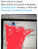
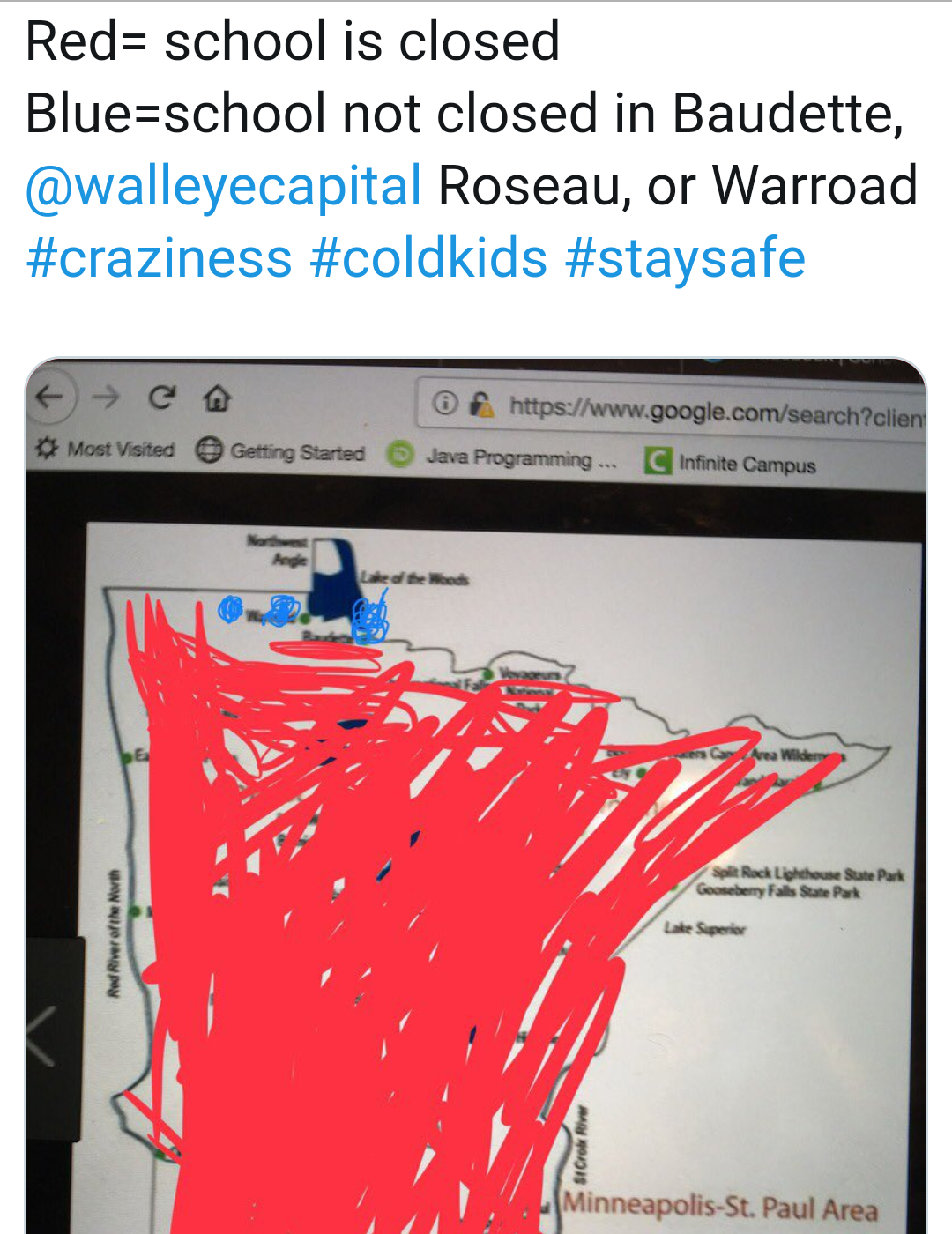
Here is the school closing situation for Minnesota at this time. If I had a school age child I wouldn't want them on a rural bus route by Tuesday afternoon. The margin for dangerous conditions for something like a mechanical failure is too small.
-
3
-
-
Forgot to say this the other day when I saw a post from you, but welcome to the forum! Always nice to have another MN member here. Good luck the next few days up there.
Well by Wednesday afternoon I should be in Phoenix. But I have to drive to Fargo first, which may be an adventure through cold and blowing snow...
-
My point forecast was a low of -20 for this morning. Only -8 so far. The wind is the main reason for the difference I think. This makes it hard for me to believe it's going to be less than -30 with the kind 10-20 mph winds forecast Tuesday and Wednesday.
It's going to feel miserable with the wind but absolute low temps might be limited by poor radiational cooling conditions?
-
2
-
-
It only got to -36 officially here. The strange thing is it started warming after 3am.
What's the driest air can get naturally in the atmosphere? I feel like whatever the answer is, that is what was here last night. As if I could here the snow undergoing sublimation and then recondensing.
-
2
-
-
Watching the trend of the models for this storm it wouldn't surprise me for each model run to continue creeping north.
Im guessing many here probably don't watch the trends when clipper like systems are forecast to move across central Canada because they are so far from being potential snow producers for most here.
The trend north hasn't surprised me it's pretty common I have found.
Now that I said that it will probably trend back south...
-
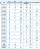
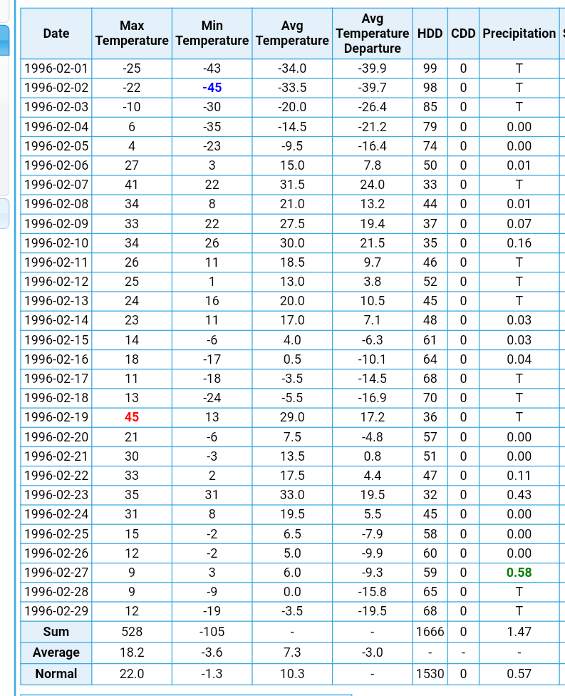
This is the Feb 1996 summary for INL. The all time mn state low was set nearby in Tower at -60f on the 2nd. In five days after temps went from record cold to over +40f for an 80+ degree temp change. All with deep snowcover.
nature is fully capable of drastic warmups regardless of snowpack.
-
3
-
-
-34f this morning. Arctic sunshine if there ever was.
-
8
-
-
In actual air temps our forcast lows are actually warmer than we had last weekend up here. But it looks like the winds will be a factor unlike last weekend.
-
1
-
-
Last year one of my classes had half the students gone, and I had 2 that just got cancelled due to the professors being sick. I somehow never came down with the flu (though I admittedly faked it once) despite how bad the epidemic across the state was.
They closed school last Friday here due to influenza. Turned a 3day weekend into 4. I guess it was a train of kids walking out the door legitimately sick on thursday.
I think mn has a rule that if a high enough % of kids are out sick one day the school must close for at least the next day.
-
1
-
-
The rich get richer. Man northern Wisconsin can't catch a break this winter.

If you wanna see who really can't catch a break snowise, parts of nw Ontario still only have 2-4" snow depths.
-
1
-
-
Agree with grizzcoat, 1991 Minnesota Halloween Blizzard is the obvious number 1.
I was only 8 at the time and grew up near St. Cloud so the Twin Cities and Duluth got higher snow totals, but I can remember by dad pulling my 5 year old sister in a sled, house to house trick or treating.
By 10 pm there was enough snow that my Dad asked me if I wanted to go for a snowmobile ride. We went right down the middle of the road without an issue. My cousin who was going to college at the time in Duluth talks about how they used their hockey sticks to dig out the car to get to the liquor store and back....multiple times throughout the storm.
Recent memorable storm would be March 31-April 1 2014. It snowed 18" on top of a over a foot that was still on the ground. I have never seen it snow so hard for such a period of time that night. It was the cherry on to top off a crazy, snowy, very cold winter. Prior to that stortm the largest snow event locally that winter was 4".
-
3
-

February 2019 Observations and Discussion
in East of the Rockies
Posted
Agree with you about the west to east sliders as you put it. Until storms start cutting SW to NE nothing truly memorable is going to happen for anyone.