


Beltrami Island
-
Posts
368 -
Joined
-
Last visited
Posts posted by Beltrami Island
-
-
29 minutes ago, Minny_Weather said:
Best it comes then, I think the general consensus is that by March everyone is longing for Spring.
I'll be the exception....
When it's good, March snowmobiling is the best. Long days, bright sun, and the potential for the biggest snowstorms of the season. I'd gladly give up December snowmobiling to guarantee it in March.
I guess the caveat is you probably have to be in traditional snow area... UP, Northern Minnesota or Northern Wisconsin, etc
-
3 hours ago, Madtown said:
This is gonna make for a brutal fire season out there
Oh man, wasn't even thinking about that. MT, ID, and WY are so over run with pine beetle killed trees the whole region could be a tinder box.
I did snowmobile trips each year from 07-13 to the same lodge near Yellowstone . Each year I could see the slow crawl of beetle killed trees expanding. When I went back in 2019 I couldn't believe all the dead trees... Entire mountain sides went from lush pine trees to dead timber. I can't imagine it now.... End result of 100+ years of snuffing out every small fire in a region that needs fire to regenerate itself.
At least we will get pretty sunsets out of it possibly.
-
2 hours ago, Madtown said:
It is brutal up here...typical Nov out on the trails. Nothing is froze, no/low snow. Business is absolutely brutal for many right now. Hopefully Feb and maybe March turns out, but this could be 4 mo of lost revenue for many. From Lake Gogebic on north to Copper Harbor is the only spot up here thats rideable atm. 2015-2016 wasn't even this bad.
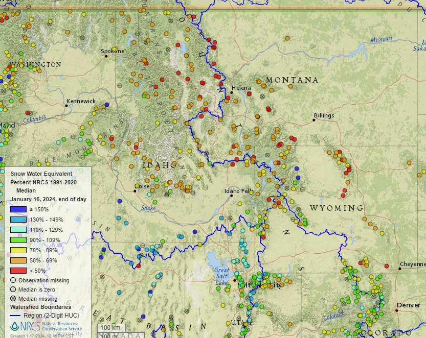
Not in this sub, but Idaho, Wyoming, and Montana are hurting big time, not just the northern midwest. All those reds and orange dots don't just represent below average, in a lot of cases those sites are at or near all time (30-40 year history) low snowpack for this point in the season. Utah and Colorado got in the storm train that has gone through the central Midwest.
There have been some big turnaround winters for the northern midwest after after very low first half winter snows. 2005-06, 2012-13, 2018-2019, and 2021-22. Unfortunately, all those years are either ENSO neutral or La Nina.
-
 1
1
-
-
3 hours ago, Grizzcoat said:
-22F at my place. Coldest I've ever seen in 25 years
When SE Iowa is colder than northern Minnesota and has more snow than Houghton, MI in mid January, you know it's a weird winter.
-
 3
3
-
-
4 hours ago, Grizzcoat said:
12Z GFS says Nanook of The North returns a little over a week from now.


Something about a 1058mb High pressure over Montana and not breaking -20 over the prairie provinces seams wrong. I'd expect widespread -20s, some -30s and maybe approaching -40 in a few spots. Or, is this just unreliable to look at specific surface temps this far out.
-
2
-
-
3 hours ago, Minny_Weather said:
Models are bringing back the idea of a clipper pattern. I'll believe it when I see it.
The grass is (barely) covered thanks to this last storm so it finally looks like winter here in Lakes Country. Let's slowly pile on.
The most frustrating thing about a clipper pattern/nw flow is the wildly different snowfall outcomes possible from very similar 500mb patterns. And when it is good, the clippers just sort of show up 2-4 days out on models because on the synoptic scale they are so small.
-
1
-
-
Finally got below 0 (-2f) for the first time this winter, might be the latest first below 0 reading for a winter on record here. Looking back at some warm winters in my memory and we still had below 0 temps sometime in December those years.
-
1
-
-
If you asked my ideal winter 500mb pattern over North America. This is what I would draw. If this pattern sets up for a few weeks there is so much potential for clipper train over the northern US but at the same time all it takes is a clipper/pacific wave to dig a little SE from the PNW and Colorado lows are easily possible that have plenty of cold water to work with...
The biggest problem right now is El Ninos tend to never actually achieve this setup, it stays 10 days out in the computers and never becomes reality. If this were a la nina or anything besides a moderate/strong el nino I would be pretty giddy.

-
1
-
 1
1
-
-
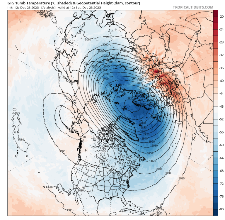
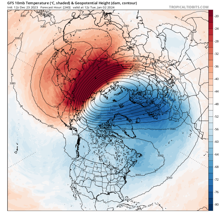
3 minutes ago, Black Hole said:
GFS shoves a PV lobe over NA on its 12z run. Nice to see this since most other runs have not done this.
It means more to show the changes from current to something prior to model fantasy timeframe to demonstrate there are substantial changes likely coming. Look at the difference between t0 and 240 hours. I don't know what the changes might mean in regards wether on the ground but it's a change nonetheless.
-
After a solidly white Halloween, looks like its going to rely on this being accurate for a white Christmas. I think the last fully brown Christmas for mby was possibly 1999. 2011 just barely escaped with minor snowfall 23rd-24th that pretty much all melted a couple days later.

-
1
-
-
1 hour ago, gabel23 said:
Interesting article about the current state of the drought in my area. I never realized some places are running 25-30" below average for the year! Ever since the floods here of 2019 we have been running below. I have talked to a lot of old timers and obviously the 30's stands out as the worst. Some farmers I have talked about said the 50's was worse. We are currently there right now. Gonna take a lot to get out.
I remember hearing the 50s drought was worse than the 30s as well other places online... The difference is the farming practices in the plains were much improved by the 50s (or terrible leading up to the 30s, depending on your point of view) that the dustbowl didn't repeat in the 50s.
-
2
-
-
29 minutes ago, Minny_Weather said:
I'll take this in a heartbeat. Even though I won't be here for it, it'd be nice to have white ground for the remainder of winter. I do believe we will turn cold at the end of the month.

Pretty much a cutoff low that finds enough cold air to produce snow, could just as easily be rain. But, I guess until there is some typical cold air over Hudson Bay, a cutoff low is about the best we can hope for with an El Nino and Aleutian/Alaskan trough.
-
2
-
-
50 minutes ago, Iceresistance said:
Asia is getting the extreme cold right now, it is projected to move towards Alaska before setting up for somewhere in the CONUS
I have always been under the impression Arctic air for the CONUS doesn't come from Alaska as a very strong general rule. Usually Nunavut or Greenland with cross polar flow is the source. Anything is possible but waiting For a PV to drop from Alaska to the CONUS is very rare.
-
1
-
-
28 minutes ago, Iceresistance said:
Except that 2011-2012 was a La Nina and this is an El Nino?
Oh, don't get me started on that year. It was a La Nina, but acted like El Nino.
-
2
-
-
I have some dread seeing this. It looks very much like 2011-12 to me. Great for snow if you are in S/SE Alaska... Pretty much everywhere else not so good for snow.

-
1
-
-
On 10/30/2023 at 7:03 PM, Madtown said:
Really not liking this winter hope I'm wrong, but for a Nino to turn decent everything else has to play ball in perfect unison. Not sure we are that fortunate this year
I agree with you...This late October early November cold usually flips to warm and dry by thanksgiving during el nino this far north.
I feel like best case scenario with el nino is a 4-6 week long northwest flow pattern over the northern plains/upper Midwest from Christmas through January that has some good clipper action. Hoping for any pattern that leads to Colorado lows cutting hard nw is fighting against nino climo.
-
1
-
-
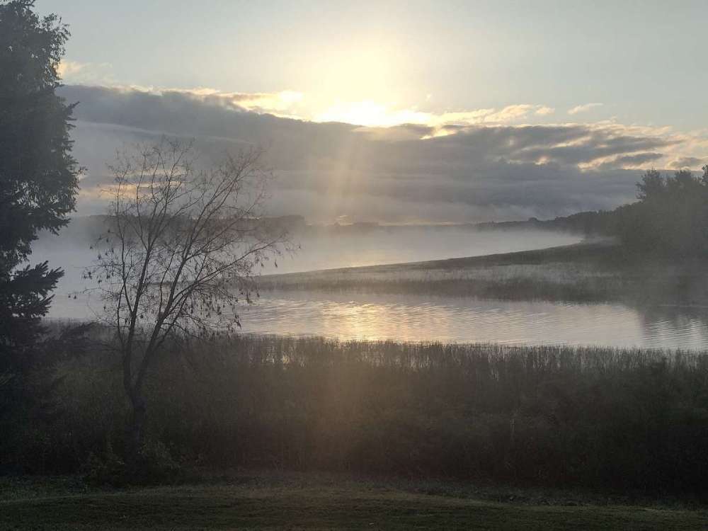
It didn't get as cold here as further south and east of me but still had patchy frost. This phenomenon seems to happen every fall during first frost season. Still, the Rainy River had some cool fog over it this morning. Of course pictures don't do it justice. Canada on the left side, MN on the right, the Baudette Bay(river) in the foreground entering into the Rainy.
-
9
-
-
Enduring 90% RH here right now with a temp of...….59f and forecast high of 65f! It might get up into the 80s here in a couple days.....
I honestly endure the -30s in winter happily imby rather than deal with the heat and humidity you guys in MO, KS, OK, and TX have right now.
-
On 5/16/2023 at 3:48 PM, Madtown said:
Sounds silly after just melting 30"+ of snow less than 3 weeks ago, but we need rain! Everything is bone dry and water levels running a bit low. Last pile of snow still hanging on
I have experienced the same thing with heavy snow/late dry spring years. Even with a muddy mess on the ground as its melting. I guess the ground frost keeps the water from soaking in to the ground and it just runs off? Its seems like it ought to soak into the ground more, but nope.
-
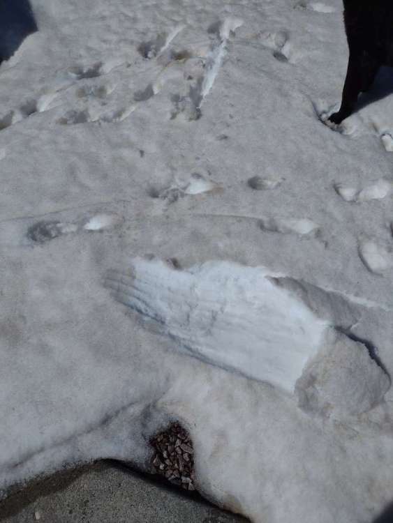
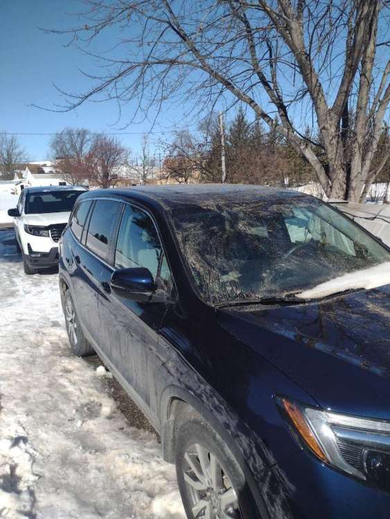
Can anyone explain what the cause of dirty snowfall from the April 4-5 snowstorm could be? As that snow is now melting it's leaving a residue on vehicles, roofs, and on the snow itself. It's widespread over miles as well.
The only thing I can think of is dirt from the Iowa tornadoes getting pulled way up and depositing on the nw side of the low up here on the MN/Ontario border. Seems far fetched but looking for other ideas.
-
1
-
 1
1
-
-
2.0" of QPF for Thief River Falls shown here to fall as all pretty much all snow. Pretty crazy as there is no elevation or lake enhancements going on in NW MN.


-
1
-
-
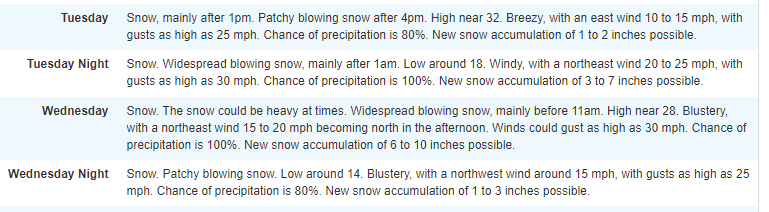
5 hours ago, Tom said:
0z Euro...cutting it a bit to far NW for our MN peeps to reel in the higher totals... @Beltrami Island

Grand Forks hasn't committed to any amounts yet in my point forecast. Just to the east, the Duluth office has 11- 22 in the point forecast. Near 50 by the weekend is going to make for one heck of a mess even if 11 happens.
-
4
-
-
7 hours ago, Tom said:
0z EPS...Big Snow targeting the Dakotas into @Beltrami Island back yard...
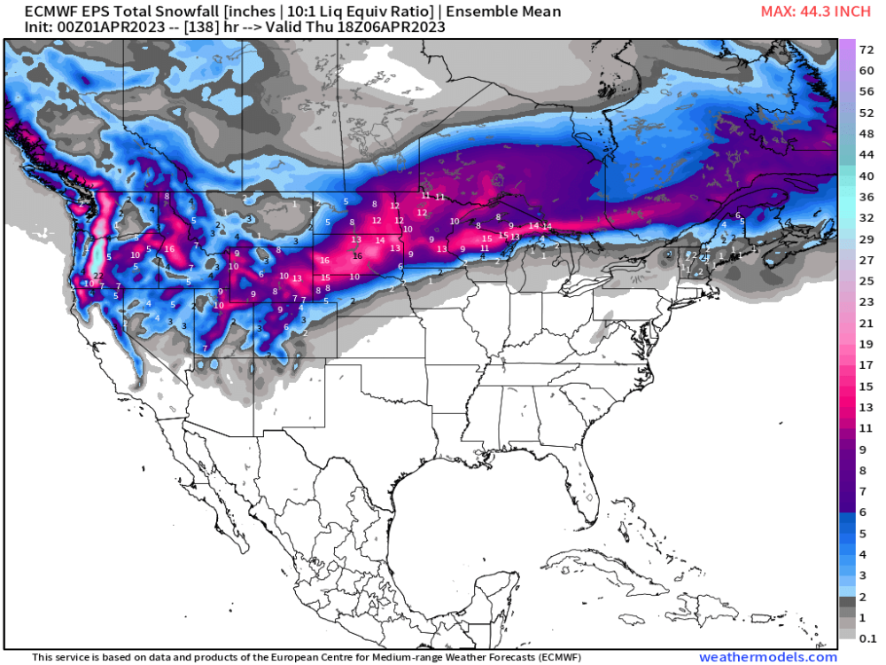
Oh I've been watching this. This thing better deliver the goods for solid double digit accumulation. It's a couple weeks too late to be happy with a garden variety 6-8" storm.
-
 1
1
-
-
3 hours ago, hawkstwelve said:
NAM and RGEM have been weakening over the past few runs.
3 hours ago, hawkstwelve said:Pretty large drop on the FV3 as well.
Of course right as NWS FSD issues a WSW the models will all go down the pooper. It would certainly fit with the pattern of the last two storms where models show high amounts just 24-36 hours prior but we end up with only an inch or two.
I am not sure if this statement is true, just my point of view watching weather models....
For whatever reason the medium range models, all of them, seem to consistently under estimate the ability of the western US/Canada mountains ability to remove moisture from the air column as storms move over them.
As a result, for storms that move over those ranges out west that don't immediately tap into Gulf of Mexico moisture when they get to the plains, the models overdue qpf. Only when the storm is close to or across the mountains do the models finally realize (get data) about the actual lower than previously forecast moisture that is left in the atmosphere.
-
2
-


January 2024 Observations and Discussion
in East of the Rockies
Posted
A few years back I agreed to help coach hockey after a few years break from coaching. I went into that hockey season fearing the struggle, on all fronts, that season looked to become. Then thinking more I thought, well maybe a few things would turn out better and it can't possibly turn out as bad as I feared. Only for it to turn out exactly as I had initially feared.
I feel very similar about this winter.