OmahaSnowFan
-
Posts
2693 -
Joined
-
Last visited
-
Days Won
1
Everything posted by OmahaSnowFan
-
Just had a line move through here and dump another quick .60" of rain. My station reported a peak rate of 2.41" hour. Speaking of rainfall rates, Falls City, NE had .75" of rain in just 10 minutes at one point yesterday. A rate of 4.5"/hr!!
-
Had another little over 1/2" last evening so ended up with 1.32" of rain yesterday.
-
Storms really weakened in my part of Omaha. Had some gusts to 40-45 mph but that’s it. Ended up with .74” of rain. Meanwhile just 25 miles west of me…

-
Wow! Severe tstorm watch issued for scattered wind gusts up to 90 mph!! That’s one of the highest wind speeds I’ve seen for a watch here in quite a while. Normally 80 mph is considered a high number for possible wind speeds. Also, we’ve now had 3 severe tstorm watches this month. 2 that ended at 5 am, and the other that ended at 11 am.
-
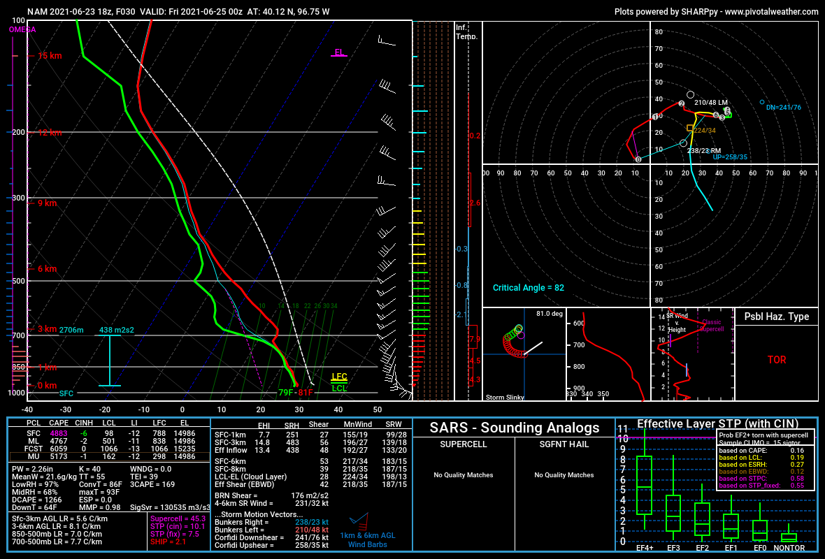
21Z HRRR looks pretty good for storms here tonight and heavy rain amounts as well. I keep putting off watering hoping for it to just rain so hopefully that happens the next couple of days. The 18Z run of the NAM looked pretty darn amazing for sups tomorrow along the NE/KS border. Another model that's been all over the place for tomorrow's weather so I hoping it's picked the right solution. I've seen multiple chasers mention that run and if it's true, could be a big day tomorrow for tornadoes. TONS of CAPE, temp/dewpoint spreads of only 2-4 degrees, lol with temps in the low 80s and dews near 80, and even better showing tons of low level CAPE.

-
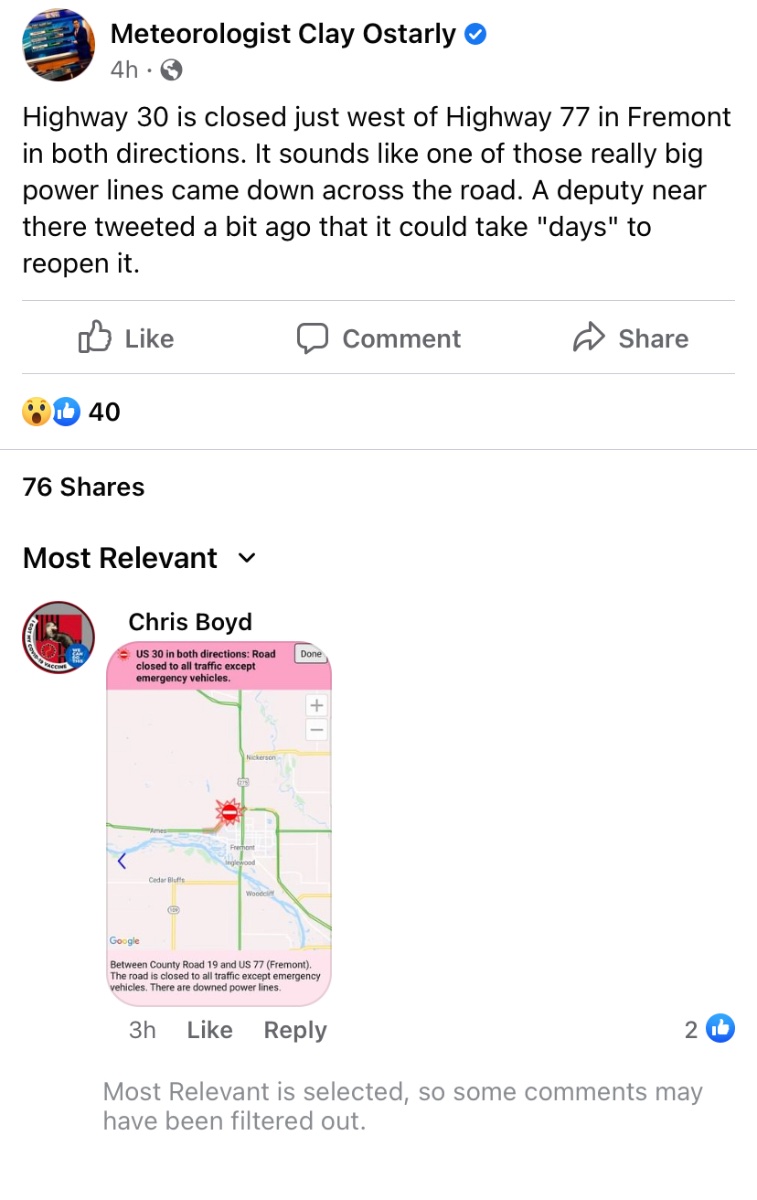
My sister lives just outside of Schuyler and shared a picture of the corn crop shredded down to the ground basically from last night's hail and wind
-
Northern Missouri added to an enhanced risk for tomorrow....

-
I've seen some recent runs showing 12-15" in a small area in southeast Iowa!
-
Man the CAMs seem to be completely clueless about storm placement and severe chances tomorrow and Friday. Each model seems to be different on placement and parameters.
-
Here's the video I took of the Pella, IA tornado from Father's Day. Was rated a high end EF-1. Unfortunately I missed the beginning of the tornado on the video as I was just pulling up to this spot, so the majority of the video is when it was a funnel going up and down. *make sure to switch to HD quality if it doesn't start that way*
-
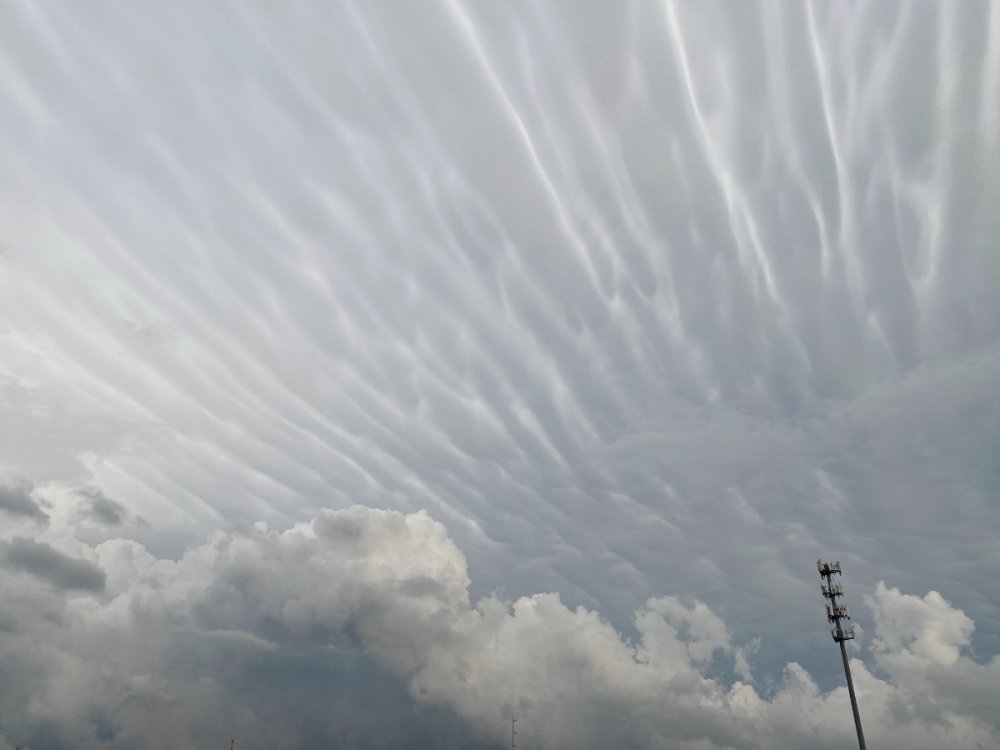
Chased today in Iowa and Happy Father’s Day to me! I started with the cell that went by Newton. It had broad rotation at times and eventually I drove through some quarter sized hail. That storm started sagging south and new storms formed southwest of there. I eventually made a break for that storm and watched as it got better organized. Just before Pella it went tornado warned. I ended up taking a gravel road to take some structure pics of the inflow and hail shaft. I headed on after about 5 minutes and unfortunately that ended up costing me a bit. As I headed back towards the highway I suddenly could see the big bowl shaped lowering west of Pella. I wanted to get closer but also didn’t want to risk not stopping in time to get any pics/video so I stopped on the east side of town and was able to get about 6-8 minutes of the remaining funnel and wall cloud before it dissipated. A new wall cloud cycled east of there maybe a mile up the road from me, causing the sirens in town to go off again but nothing formed. The storm then weakened thereafter. On the way home I saw the coolest mammatus I’ve ever seen and saw some damage to a farm west of Pella from the tornado. Quite the fun chase!

-
Yep, it’s rained 1x here this entire month. Thankfully was a bit more at .55”, but still not enough. Been watering the lawn for the past week now.
-
I’m liking Sunday for eastern Iowa. Looks great for severe storms
-
HRRR doing pretty good with the main show so far showing it up in Minnesota and Wisconsin. Glad I didn’t head out chasing to northern Iowa!
-
Impressive!
-
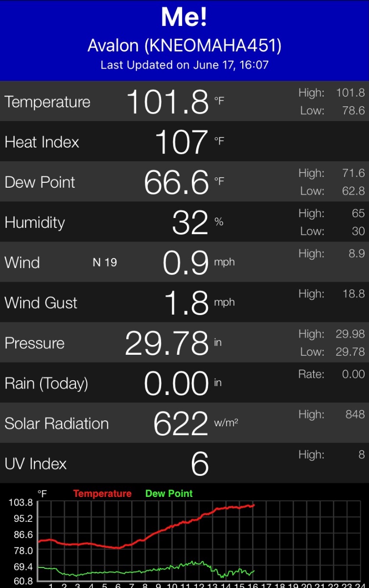
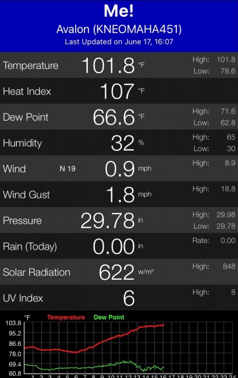
101.8 so far on my station. Hottest temp it’s ever recorded in the 3 summers I’ve owned it.
-
So will the SPC be wrong or basically every CAM that shows pretty much no storms until after dark/near the Iowa, Minnesota, and Wisconsin borders. I smell a huge bust.
-
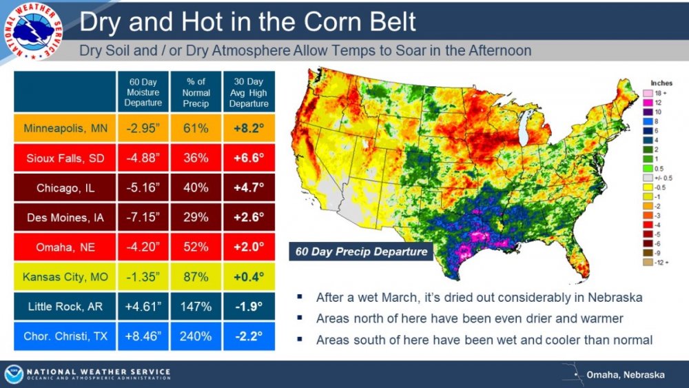
We're under guidance for today's high. Only hit 93 so far today, but the dews have returned back to near 70 so the HI on my backyard thermometer has been running 98-100. Actual air temp was supposed to hit 97 today. Tomorrow they've upped the grids to 103-105 across the metro.
-
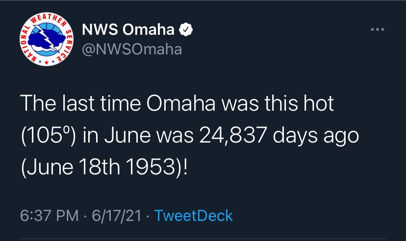
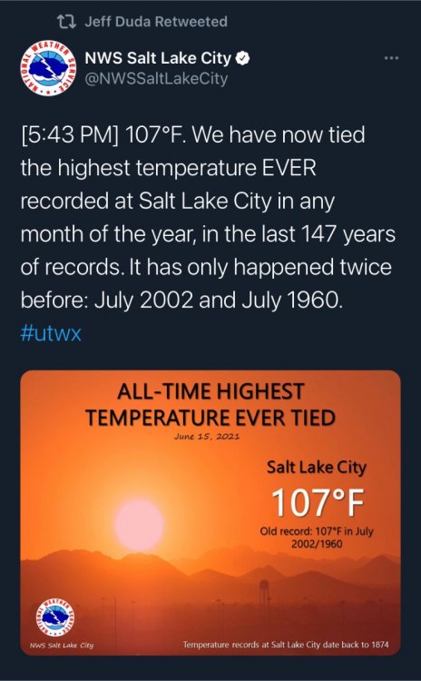
Setting all time records in June….
-
-
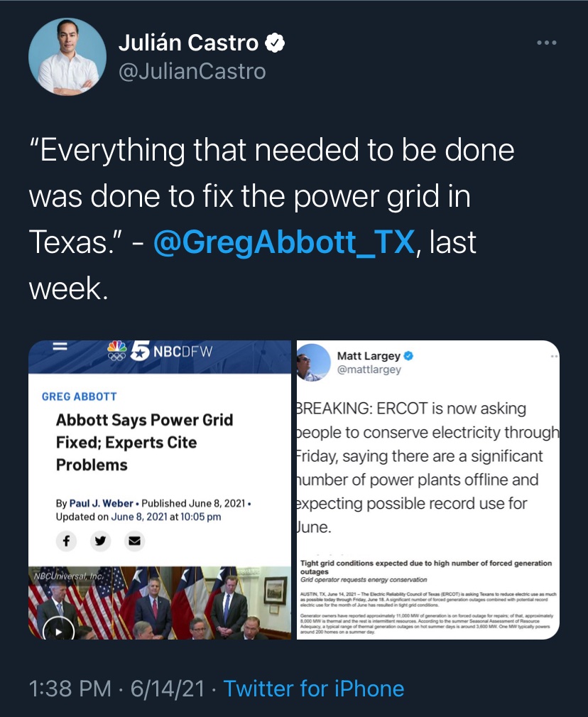
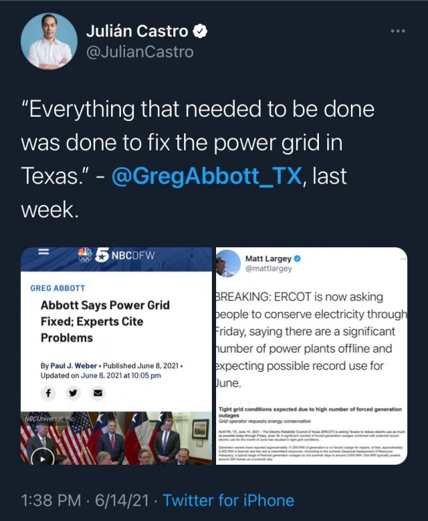
Yeah if only the government of that state would have done something about it to help protect it's citizens.... I know, it's all about government staying out business, even if that's forcing a company to update it's infrastructure or going out and finding another company to come in and build a plant
-
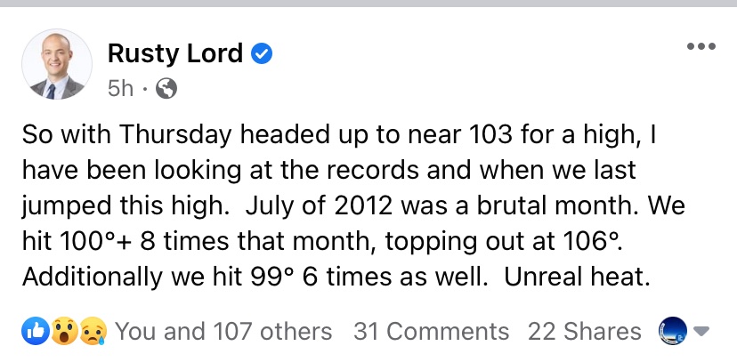
I remember how bad ‘12 was but man I forgot it was THIS hot..
-
Mmmmm…..
-
Very impressive highs forecast Wednesday across almost all the models. A large area of 100-110 degree highs showing up on the maps over the central Plains
-
Don’t blame Abbott and the rest of the GOP. They were busy trying to secretly pass voter restrictions, attacking women’s rights and their bodies, attacking COVID measures, and allowing permitless carry, instead of updating the power grid like they were told to a decade ago.