OmahaSnowFan
-
Posts
2693 -
Joined
-
Last visited
-
Days Won
1
Everything posted by OmahaSnowFan
-
Hit 95.9 today for my warmest temp so far this season. Averaging 90 this month, which is actually cooler than our start to June last year when I averaged almost 92 degrees the first half of the month.
-
Have a high of 101 in the grids for Thursday. 100s are actually pretty rare here. Only hit 100+ 5x since 2013.
-
-
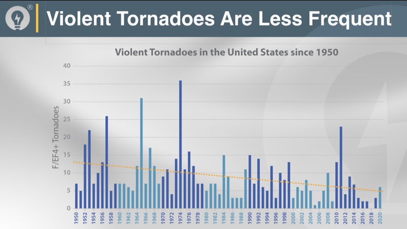
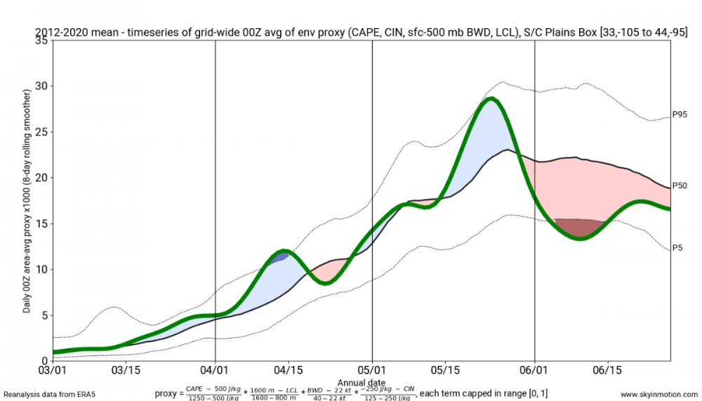
Not winter weather related for this forum, but pretty interesting data on severe storms and how the season has worsened and shortened for the US from a chase forum I am on. "In short, this suggests that between 2012-2020, the entire month of June underperformed 1950-2020 climo as a whole by a large margin WRT coverage of reasonably favorable Plains environments. For early-mid June, 2012-2020 mean coverage is frequently under the 5th percentile for what you'd expect of random 10-year draws from the full 60-year distribution. Also plainly evident is the mid-late May spike in favorable environments, corresponding to what many of us have called the "compressed seasons" of recent years. Basically, it's been a good period to chasecation within the traditional May 15-30 window, but middling to awful outside of that. In fairness, early-mid April have also offered favorable environments significantly more often than the 60-year climo as a whole, although the absolute payoff to chasers so early in the year is fairly limited. Now consider that when I'm able to add 2021 in a few weeks, the 10-year running coverage for June will very likely -- astoundingly -- fall even further. For all the talk of the sky falling and climate change wiping out all convection that can at times have an irrational, knee-jerk component, June is the segment of the core Plains season I'm really worried about going forward. This run the past 10 years is appalling from just about any perspective. When you combine the empirical data on environments over the past decade with fairly uncontroversial impacts from AGW, including warming Gulf SSTs (e.g., the NHC talking about moving the official start of Atlantic hurricane season to mid-May), there's a lot to unpack."
-
I remember driving around neighborhoods after the Christmas storm and the mountains of snow was unbelievable. And it stayed forever! I actually liked last winter for the most part. Minus the 2 weeks in February, every month would have averaged above normal and we had above average snowfall, although nothing really big IMBY. Of course the snowfall suddenly ended in mid February too.
-
Wash, rinse, repeat..... things not seen before or in decades are showing an epic winter is coming, then fail again. And again. See topic here: They need a support group for people addicted to winter weather
-
Ended up with .55” of rain at my place and no severe weather. Not going to be enough to last the next dry week coming up though. First rain in almost 2 weeks. Had our first watch of the season and it was a severe tstorm watch covering 8a-11a of all times I’m free all next week to chase anything and not surprisingly looks like nothing happening again.
-
What’s funny is we started June last year having the first 9 days above 90 degrees here. The grids all upped the temperatures for this coming week and every day is above 90 so we might do it again
-
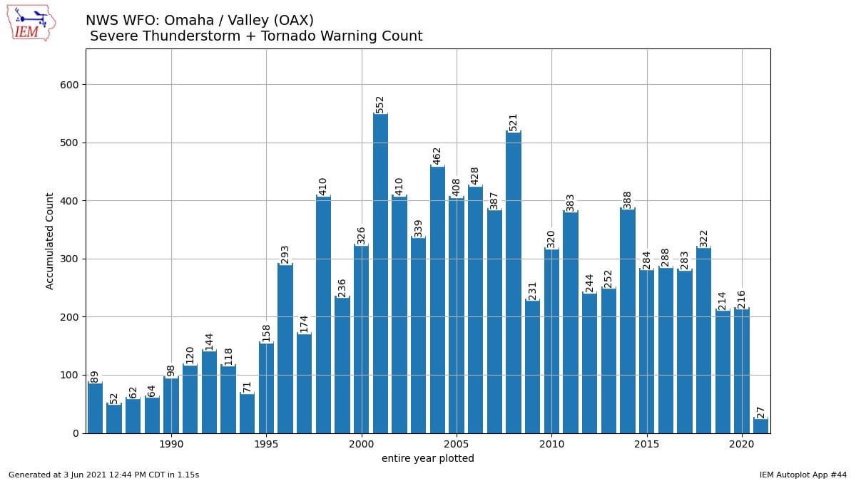
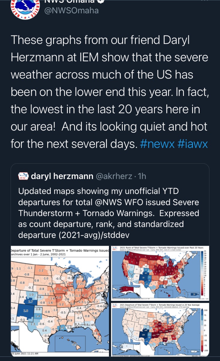
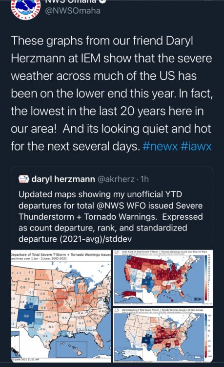
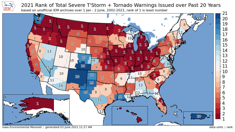
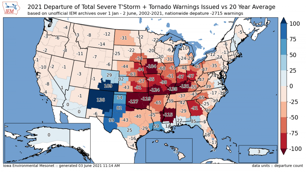
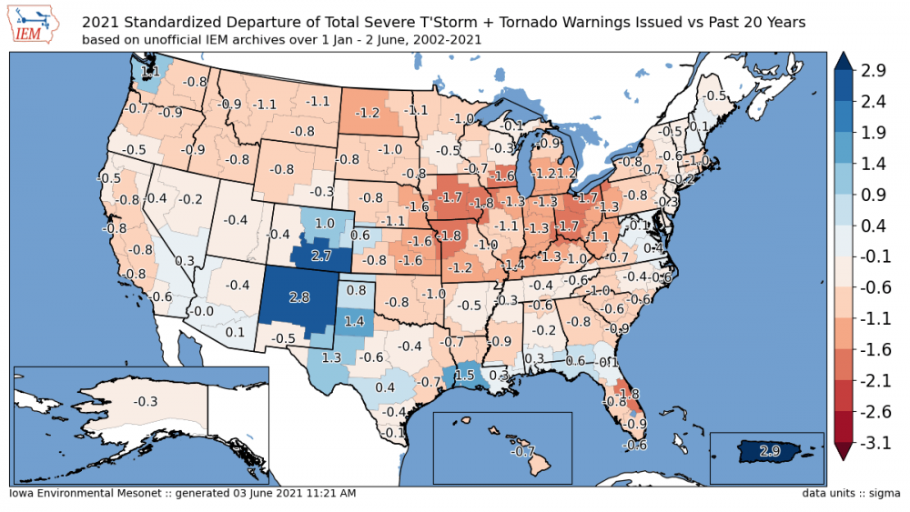
Omaha posted a graphic showing it’s the lowest number of warnings in our CWA in 35 years

-
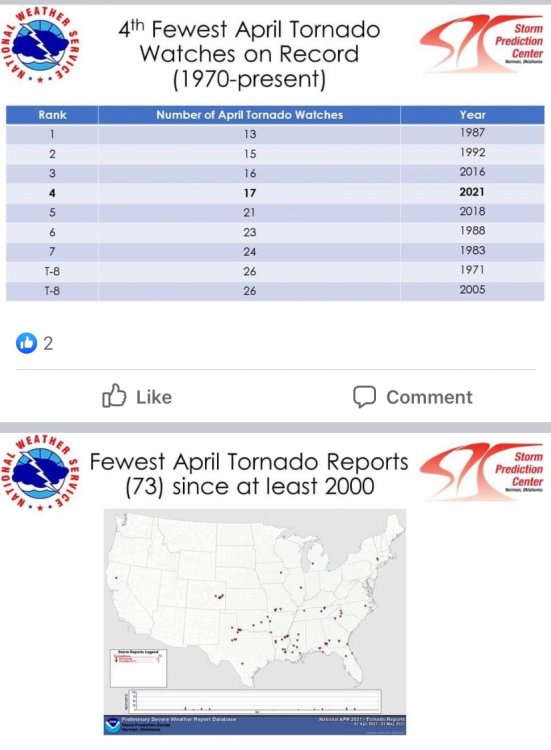
Slowest start in 20 years for most of the Midwest
-
Severe weather looks promising.... if you’re in Canada.
-
My May stats from my backyard. Avg low: 51.7 (1.0 below average) Coldest low: 34.7 (5th) Avg high: 71.9 (2.7 degrees below average) Warmest high: 87.8 (1st) Precip: 4.03" (.63" below average) Rained 14/31 days but still ended up below average in precip. No severe weather watches or warnings for my county.
-
Looks like we'll make it through the entire month of May without a single severe weather watch for Omaha. I remember when May used to bring severe weather around here..... So much for another supposed active severe weather season too.
-
Ended up with 1.06" of rain. Mainly just some moderate rain with embedded thunder at times. Definitely not the result it looked like would happen yesterday/last night. I'd say a huge underperformance for the severe weather yesterday. There were a few tornadoes and big hail, but most of western Kansas stayed shut off. There were storms that formed late morning and probably messed things up even for those of us in central and eastern Nebraska as the squall line never really materialized. Plenty of storm chaser were really disappointed/pissed off with yesterday's results.
-
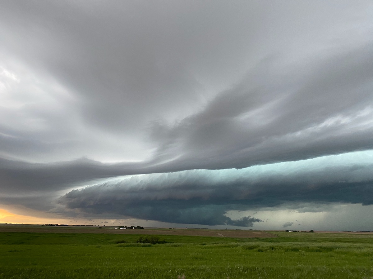
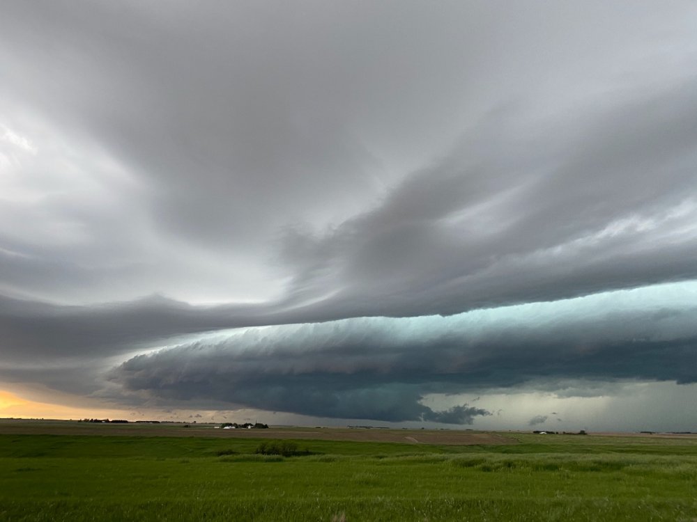
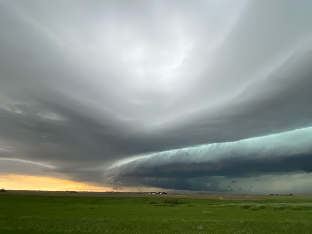
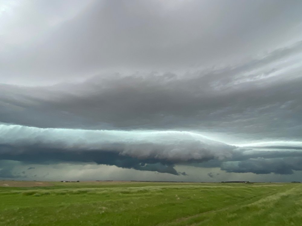
I was also there. Beautiful storm that wasn’t even severe warned! IMG_6987.MOV

-
I understand most of the numbers and indices thanks to my meteorology classes at UNL and lots of studying online. The curved shape of the hodographs up I n the top right is about as perfect as you will see for a tornado sounding! I agree. It’s nice to be able to see the storm structure etc. Not to mention I’d rather have the possible power outages during the day although I guess it’s not as warm at night.
-
Yikes!!
-
Omaha NWS AFD: A vigorous shortwave trough will move through the northern Plains while a surface low develops from eastern CO into eastern NE by 12z Thursday. A warm front will lift north ahead of the surface low with dewpoints rising back into the lower/mid 60s to the south of that boundary. Consensus of available model data suggest that storms will quickly grow upscale into a convective system over western NE during the evening hours. Farther east, various models have shown some signal for more discrete storm development along and north of the warm front during the evening from central into eastern NE. There is considerable model variance in the characteristics of the low-level moisture profile in the vicinity of the warm front, especially from mid to late evening. The nocturnal strengthening of the low-level jet will result in large, clockwise-curved hodographs, suggesting a conditional supercell tornado threat downstream from the evolving QLCS, assuming 1) in situ storm initiation along the warm front, and 2) storms are surface-based within the moistening boundary layer. Otherwise, expect that the QLCS will track southeast along the immediate cool side of the warm front with the system moving through the majority of our area after midnight. Damaging winds will be the primary severe weather hazard. However, tornadoes will be possible with any embedded mesovortices and/or HP supercells. Locally heavy rainfall will also be a concern.
-
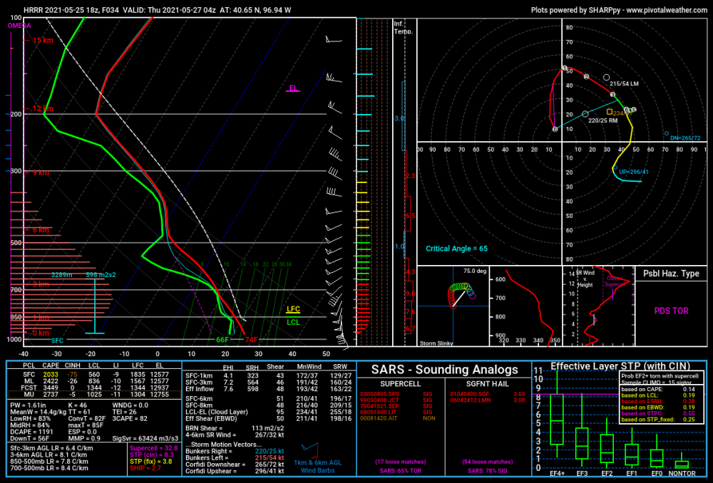
18Z HRRR is pretty scary looking for Nebraska tomorrow. Develops what would probably be tornadic supercells out ahead of the main line tomorrow evening in east central Nebraska and then has a big squall line go across the state. Shows 3-6" of rain for east central Nebraska as well. Very impressive soundings as well even well into the overnight when surface based CAPE normally disappears. Most models are showing 2-3k of surface based CAPE and 40-60 knots of shear all through the night. Could be a pretty bad night Wednesday night.
-
Another cloudy day with some lt rain earlier and now again this afternoon. The heavier rain looks like it's staying just east and south of here. I've had .06" of rain so far today and that now makes 11 out of 20 days with measurable precip so far this month. This pattern sucks. It's finally warmed up a bit so that's not bad, but the clouds and lt showers are annoying. What looked like a possible great severe weather setup this weekend too has fizzled thanks to the ridge in the southeast that hasn't let the big upper low out west move anywhere until it weakens and then moves more north than east.
-
We've had another 1/3" of inch today. Now up to 2.72" for the month and so far we've had measurable precip on 10 out of the first 19 days in May.
-
Here’s an update through April
-
Yuck. If you like severe weather, don't look at the GFS. Basically 16 days of nothing where the composite numbers of EHI or supercell composite never get above zero basically north of central Kansas and even that is only a couple of days there.
-
1.05” rain at my house
-
It's always next year that is going to be the "never ending winter" or the beginning of a climate shift. That call has been made for several years in a row now. I can guarantee you I can go back to posts last year talking about the same thing and the year before that, etc. Can't wait to see what next winter's forecast is going to be. Actually I already know.....