

joaqweri
-
Posts
199 -
Joined
-
Last visited
Everything posted by joaqweri
-

February 2019 Weather in the Pacific Northwest - Part 1
joaqweri replied to a topic in West of the Rockies
in anticipation of this weekend's potentially historic snowstorm, im watching this timelapse again of the historic snowstorm in the northeast 3 years ago. dropped 2-3ft along the I-95 corridor. -
February 2019 Weather in the Pacific Northwest - Part 1
joaqweri replied to a topic in West of the Rockies
don't think so. winds have been calm most of the time. -
February 2019 Weather in the Pacific Northwest - Part 1
joaqweri replied to a topic in West of the Rockies
still shows a good 6" for the victoria area in the latest run. don't lose hope! -
February 2019 Weather in the Pacific Northwest - Part 1
joaqweri replied to a topic in West of the Rockies
winter storm watches are issued 2 days prior at the most, so i'd expect them to issue either tonight or tomorrow morning. -
February 2019 Weather in the Pacific Northwest - Part 1
joaqweri replied to a topic in West of the Rockies
in both the seattle and portland areas, it has the highest totals of 12-14" west of both cities. here in seattle, it would be west kitsap and in portland it would be the coastal mountains. -
February 2019 Weather in the Pacific Northwest - Part 1
joaqweri replied to a topic in West of the Rockies
here's also the 12z FV3 who anyone who hasn't seen it yet. mainly 8-12" for the sound, with the highest totals of 12-14" in west kitsap. 8-10" for seattle, tacoma, and olympia.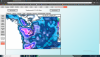
-
February 2019 Weather in the Pacific Northwest - Part 1
joaqweri replied to a topic in West of the Rockies
yeah, expecting the seattle NWS to issue a winter storm watch later today or tomorrow. -
February 2019 Weather in the Pacific Northwest - Part 1
joaqweri replied to a topic in West of the Rockies
could last longer! this is could be a big snowstorm. -
February 2019 Weather in the Pacific Northwest - Part 1
joaqweri replied to a topic in West of the Rockies
im tired. again, the 12z, not 00z. -
February 2019 Weather in the Pacific Northwest - Part 1
joaqweri replied to a topic in West of the Rockies
12z gem snowmap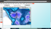
-
February 2019 Weather in the Pacific Northwest - Part 1
joaqweri replied to a topic in West of the Rockies
looking at the 00z GEM now. has snow arriving INCREDIBLY early and starting as snow late thursday night, with temps in the upper 20s for most of the central sound. heaviest of it moves through late friday night into early saturday morning. last snow showers move out late saturday afternoon/early evening. surprisingly only has totals of 6-10" for most of the sound. posting a snowmap shortly. -
February 2019 Weather in the Pacific Northwest - Part 1
joaqweri replied to a topic in West of the Rockies
only got down to 22F, bottomed out around 7am this morning. -
February 2019 Weather in the Pacific Northwest - Part 1
joaqweri replied to a topic in West of the Rockies
SPS has 2 hour late start today, but we also have 75min early release on wednesdays. today's gonna be a short day, i have no idea how they plan on fitting 6 classes that are normally an hour long into a 3 1/2 hour day -
February 2019 Weather in the Pacific Northwest - Part 1
joaqweri replied to a topic in West of the Rockies
meant to say 12z GFS ;P -
February 2019 Weather in the Pacific Northwest - Part 1
joaqweri replied to a topic in West of the Rockies
00z GFS still going with mainly 6-12" for the central sound, 10-12" in seattle and spots of 13" and 14" just north of everett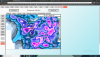
-
February 2019 Weather in the Pacific Northwest - Part 1
joaqweri replied to a topic in West of the Rockies
yall know when the 12z euro starts rolling? -
February 2019 Weather in the Pacific Northwest - Part 1
joaqweri replied to a topic in West of the Rockies
win win for all of us! -
February 2019 Weather in the Pacific Northwest - Part 1
joaqweri replied to a topic in West of the Rockies
If the models keep on this trend, the seattle NWS may issue a winter storm watch as early as today or tomorrow. Last night's forecast discussion was real exciting. -
February 2019 Weather in the Pacific Northwest - Part 1
joaqweri replied to a topic in West of the Rockies
Not much change with the 06z GFS. still going with a solid foot in seattle. -
February 2019 Weather in the Pacific Northwest - Part 1
joaqweri replied to a topic in West of the Rockies
we're getting there now. euro has already 2-4" in seattle by 10pm friday. -
February 2019 Weather in the Pacific Northwest - Part 1
joaqweri replied to a topic in West of the Rockies
euro is getting there. snow reaching SEA at 10am on friday -
February 2019 Weather in the Pacific Northwest - Part 1
joaqweri replied to a topic in West of the Rockies
you guys think this could be similar to jan 1950? that was the most legendary month in seattle winter weather history. -
February 2019 Weather in the Pacific Northwest - Part 1
joaqweri replied to a topic in West of the Rockies
alright boys, shut up and eat popcorn with me while the 00z euro is rolling out -
February 2019 Weather in the Pacific Northwest - Part 1
joaqweri replied to a topic in West of the Rockies
why? -
February 2019 Weather in the Pacific Northwest - Part 1
joaqweri replied to a topic in West of the Rockies
00z UW GFS is also rolling out now, watching for that


