


joaqweri
-
Posts
199 -
Joined
-
Last visited
Everything posted by joaqweri
-

November 2019 Weather Discussion for the PNW
joaqweri replied to TigerWoodsLibido's topic in West of the Rockies
already hearing reports of rain/snow mix up around northern whatcom county in western wa around the border. anybody able to confirm this? -
February 2019 Weather Observations and Discussion Part 2
joaqweri replied to snow_wizard's topic in West of the Rockies
anybody know if there's a pc version of radarscope? wanna be able to look at it on my pc and not only on my phone -
February 2019 Weather Observations and Discussion Part 2
joaqweri replied to snow_wizard's topic in West of the Rockies
so lemme get this straight, the deeper that trough digs the further south that low goes? -
February 2019 Weather Observations and Discussion Part 2
joaqweri replied to snow_wizard's topic in West of the Rockies
00z euro has the low making landfall right at cape blanco early monday morning -
February 2019 Weather Observations and Discussion Part 2
joaqweri replied to snow_wizard's topic in West of the Rockies
not much change with 00z euro. still 1-2" for seattle, 2-4" for portland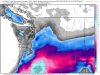
-
February 2019 Weather Observations and Discussion Part 2
joaqweri replied to snow_wizard's topic in West of the Rockies
waiting for tomorrow morning's euro to push the low into an astoria southward landfall which would lead to good snow for both SEA and PDX, an astoria landfall would be good snow for SEA, bad for PDX snowfans -
February 2019 Weather Observations and Discussion Part 2
joaqweri replied to snow_wizard's topic in West of the Rockies
00z GFS continuing southward, landfall on the OR/CA stateline and barely affecting areas north of maybe salem -
February 2019 Weather Observations and Discussion Part 2
joaqweri replied to snow_wizard's topic in West of the Rockies
????? -
February 2019 Weather Observations and Discussion Part 2
joaqweri replied to snow_wizard's topic in West of the Rockies
00z NAM has landfall somewhere between coos bay and cape blanco. good for PDX snowfans. -
February 2019 Weather Observations and Discussion Part 2
joaqweri replied to snow_wizard's topic in West of the Rockies
good sign for PDX. still praying for the 00z runs of the euro, GFS, and FV3 to either start going north or miraculously switch to an astoria landfall. -
February 2019 Weather Observations and Discussion Part 2
joaqweri replied to snow_wizard's topic in West of the Rockies
00z NAM shifted a bit north. now dropping 2-3" in SEA, 5-8" in PDX. -
February 2019 Weather Observations and Discussion Part 2
joaqweri replied to snow_wizard's topic in West of the Rockies
none of this has been good for SEA snowfans since last night's euro -
February 2019 Weather Observations and Discussion Part 2
joaqweri replied to snow_wizard's topic in West of the Rockies
18z euro snowmap for everyone who asked, this is out to 10pm monday night
-
February 2019 Weather Observations and Discussion Part 2
joaqweri replied to snow_wizard's topic in West of the Rockies
18z euro went south. 1-2" for seattle, 2-4" for portland. -
February 2019 Weather Observations and Discussion Part 2
joaqweri replied to snow_wizard's topic in West of the Rockies
18z GFS went even further south. bad for snow fans both in PDX and SEA. -
February 2019 Weather Observations and Discussion Part 2
joaqweri replied to snow_wizard's topic in West of the Rockies
yeah, the airport's snowiest feb. the airport is miles south of the city itself. the most i've had on the ground at once this month is 6", i've seen roughly a foot in total. seatac has seen 20". -
February 2019 Weather Observations and Discussion Part 2
joaqweri replied to snow_wizard's topic in West of the Rockies
bottom line: if we get another occurence where PDX gets slammed with a foot while SEA gets no precip at all and chilly temps, i'll scream till my vocal cords rot. -
February 2019 Weather Observations and Discussion Part 2
joaqweri replied to snow_wizard's topic in West of the Rockies
the NAVGEM is one model that is incredibly unreliable. -
February 2019 Weather Observations and Discussion Part 2
joaqweri replied to snow_wizard's topic in West of the Rockies
afternoon everyone. just been seeing our normal showery days here in seattle with cold lingering but im hearing of models going batshit for monday with snow. what's going on so far? -
February 2019 Weather in the Pacific Northwest - Part 1
joaqweri replied to a topic in West of the Rockies
latest NWS Seattle discussion. a winter storm watch is being considered at least. .UPDATE 930 PM...The 00z models are trickling in and the outlook for a potential major winter storm is still advertised by models. A low will move onto the WA coast and shift southeast Friday and Friday night ushering in even colder air. The low track off the Pacific should bring the necessary moisture needed for heavy precipitation. Very cold air, probably colder than the last system will quickly drop temperatures into the 20s by Friday night and Saturday. This should increase snow/liquid ratios, and some models are picking up on the heavy snow potential with well over 6 inches on the GFS. North wind and Fraser outflow will also create blowing and driving of snow. At this time, it looks like precipitation will be all snow with only a short duration of south wind if at all on Friday. The current air mass will not likely be displaced that quickly before cold air aloft moves in. It would be cold enough aloft for onshore flow regardless, at least just inland from the water. MOS is way too warm, trending toward climo and possibly 10-15 degrees too warm with highs Saturday. A winter storm watch is will need to be considered with very heavy amounts on some models, but lower end amounts still near the 4" plus criteria. Another system arrives Monday. More snow, cold, and wind could worsen any clean up and impact the commute. Forecasts should be monitored closely as significant winter weather is likely across most of Western WA. Mercer -
February 2019 Weather in the Pacific Northwest - Part 1
joaqweri replied to a topic in West of the Rockies
alright everyone, ima go experience some nostalgia and play cod mw2. i'll be back at like 10:15 or 10:20 when the euro is finally getting to the end of the storm so we can so it's whole picture. -
February 2019 Weather in the Pacific Northwest - Part 1
joaqweri replied to a topic in West of the Rockies
all eyes are on the euro now, just started running -
February 2019 Weather in the Pacific Northwest - Part 1
joaqweri replied to a topic in West of the Rockies
you're fairly late, everyone has seen the 00z FV3 already -
February 2019 Weather in the Pacific Northwest - Part 1
joaqweri replied to a topic in West of the Rockies
SHUT UP EVERYONE, EURO IS ROLLING -
February 2019 Weather in the Pacific Northwest - Part 1
joaqweri replied to a topic in West of the Rockies
im trying to not focus on the mon-tue storm until after the weekend storm moves out


