joaqweri
-
Posts
199 -
Joined
-
Last visited
Everything posted by joaqweri
-

February 2019 Weather in the Pacific Northwest - Part 1
joaqweri replied to a topic in West of the Rockies
-
February 2019 Weather in the Pacific Northwest - Part 1
joaqweri replied to a topic in West of the Rockies
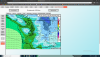
FV3 is coming in. out to 72hrs so far, shows about an inch already in seattle by 4pm friday -
February 2019 Weather in the Pacific Northwest - Part 1
joaqweri replied to a topic in West of the Rockies
jan 2017 PDX got a foot of snow. feb 2017 most of seattle got 3-4" (i got only 1.5"!) though there was 9" on the highest hills of west seattle. we didn't see a flake jan 11. i hope you guys don't get cold rain, but a foot of snow in seattle with nothing in PDX would be some actual payback. -
February 2019 Weather in the Pacific Northwest - Part 1
joaqweri replied to a topic in West of the Rockies
would be payback for january 2017 -
February 2019 Weather in the Pacific Northwest - Part 1
joaqweri replied to a topic in West of the Rockies
my school district (sps) has a 2 hour late start tomorrow so far, if it isn't cancelled because of ice on the roads the school day is only gonna be 3 1/2 because we get out early on wednesdays lol -
February 2019 Weather in the Pacific Northwest - Part 1
joaqweri replied to a topic in West of the Rockies
00z FV3 just began. -
February 2019 Weather in the Pacific Northwest - Part 1
joaqweri replied to a topic in West of the Rockies
im tempted now to tweet @ NWSeattle and ask what their blizzard warning criteria is -
February 2019 Weather in the Pacific Northwest - Part 1
joaqweri replied to a topic in West of the Rockies
yeah. evaporative cooling would likely take care of the temps with pushing them back down to freezing. -
February 2019 Weather in the Pacific Northwest - Part 1
joaqweri replied to a topic in West of the Rockies
if it comes in while snow is still dumping, we could see blowing snow and maybe even blizzard conditions in spots. -
February 2019 Weather in the Pacific Northwest - Part 1
joaqweri replied to a topic in West of the Rockies
euro is still 1 1/2 hours away -
February 2019 Weather in the Pacific Northwest - Part 1
joaqweri replied to a topic in West of the Rockies
jesus harold christ, i see it -
February 2019 Weather in the Pacific Northwest - Part 1
joaqweri replied to a topic in West of the Rockies
alright 00z gfs. 10-12" for seattle still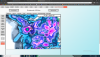
-
February 2019 Weather in the Pacific Northwest - Part 1
joaqweri replied to a topic in West of the Rockies
bottom line, gfs has precip in seattle from 00z saturday (4pm friday) until 18z sunday (10am) -
February 2019 Weather in the Pacific Northwest - Part 1
joaqweri replied to a topic in West of the Rockies
gfs has seattle reaching a more reasonable temp for snow 4am saturday, around 32-33F -
February 2019 Weather in the Pacific Northwest - Part 1
joaqweri replied to a topic in West of the Rockies
on which model snowmizer? -
February 2019 Weather in the Pacific Northwest - Part 1
joaqweri replied to a topic in West of the Rockies
gfs has snow in seattle friday afternoon at.... 36F.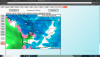
-
February 2019 Weather in the Pacific Northwest - Part 1
joaqweri replied to a topic in West of the Rockies
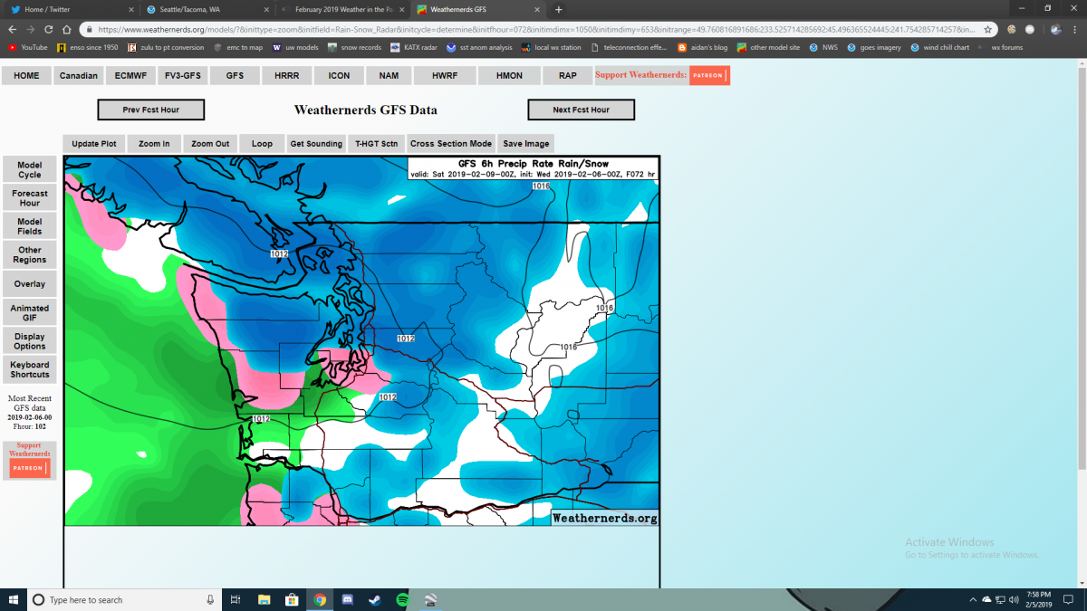
looking at the gfs closer on weathernerds.org -
February 2019 Weather in the Pacific Northwest - Part 1
joaqweri replied to a topic in West of the Rockies
precip changing over to snow completely by early saturday morning -
February 2019 Weather in the Pacific Northwest - Part 1
joaqweri replied to a topic in West of the Rockies
GEM is also starting to roll out. GFS out to 78hrs, has precip starting as mixed in seattle on friday afternoon -
February 2019 Weather in the Pacific Northwest - Part 1
joaqweri replied to a topic in West of the Rockies
https://twitter.com/AlbrechtJay/status/1092990237171638272?s=20 -
February 2019 Weather in the Pacific Northwest - Part 1
joaqweri replied to a topic in West of the Rockies
just noticed those snowmaps were from weathernerds lol -
February 2019 Weather in the Pacific Northwest - Part 1
joaqweri replied to a topic in West of the Rockies
alright boys, 00z gfs is rolling -
February 2019 Weather in the Pacific Northwest - Part 1
joaqweri replied to a topic in West of the Rockies
00z ICON snowmap is meh, 3-4" for both SEA and PDX (not to say that's a letdown, just excited by the 6-12" from the euro and gfs this morning) -
February 2019 Weather in the Pacific Northwest - Part 1
joaqweri replied to a topic in West of the Rockies
looking a bit more at this morning's euro, YWL-BLI pressure gradient seems pretty D**n wild. roughly 30mb. -
February 2019 Weather in the Pacific Northwest - Part 1
joaqweri replied to a topic in West of the Rockies
nice try, don't come in here depressing snow fans