Grizzcoat
-
Posts
4887 -
Joined
-
Last visited
-
Days Won
16
Everything posted by Grizzcoat
-
Being in the bullseye in Grand Rapids,MI 5 days out is a big difference being in the Bulls eye in Columbia,MO -- at least climate wise. Anything can happen - but I think Michigan does very well in this system compared to MO (everything being equal of course for climo reasons) MO people going to hate me. That's fine- What's the avg annual snowfall in Columbia? 17" ?? Maybe.??? Avg annual in GRR? Like 62"? Big storm- do the the math/climate. .NO way MO gets more SN out of this pattern ( next 144 hours) the Michigan. Just my .02
-
Not calling out Mr Skilling- but it appears this system (for this thread) is S of the Aleutians -- but DIRECTLY effected by it. See my satellite posts from above.-- and AFD from DMX yday PM- .LONG TERM.../Friday through Wednesday/ Issued at 328 PM CST Wed Jan 3 2024 Confidence: Medium Most of the focus is again on the system late weekend into early next week. Prior to that storm, we continue to watch a northern stream wave/trough tracking east through the region Saturday and Sunday. Friday clouds and weak south flow will continue to keep highs in the 30s over the region. The first chances for any precipitation should arrive later Friday evening into the overnight hours with slight chances for light snow. A dusting of snow is anticipated over the north and the south/southeast late Friday into Saturday. The trough is expected to exit the region by late Saturday evening into early Sunday. High temperatures Friday into Saturday should hold in the 30s again with lows in the teens north to the 20s south. Sunday is a transition day between the approaching early week storm and the minor weekend event. Today the impulse that will become next weeks system is still well off in the North Pacific Ocean, roughly near 175W/45N and still 2.5 days from reaching Oregon Washington coasts of the Pacific Northwest by 12z Saturday.
-
Just looking at the satellite in the North Pacific ( stretch I get it) the system appears faster. It's booking at like 50-60 MPH- at least at Sea Level. https://weather.cod.edu/satrad/?parms=global-npacwestlarge-13-24-1-50-1&checked=map&colorbar=undefined

-
For Michigan peeps- and BTW- GO BLUE!!!! - that Husky QB is the real deal however.
-
Good ole' fashioned mid latitude cyclone - the largest storms on Earth-
-
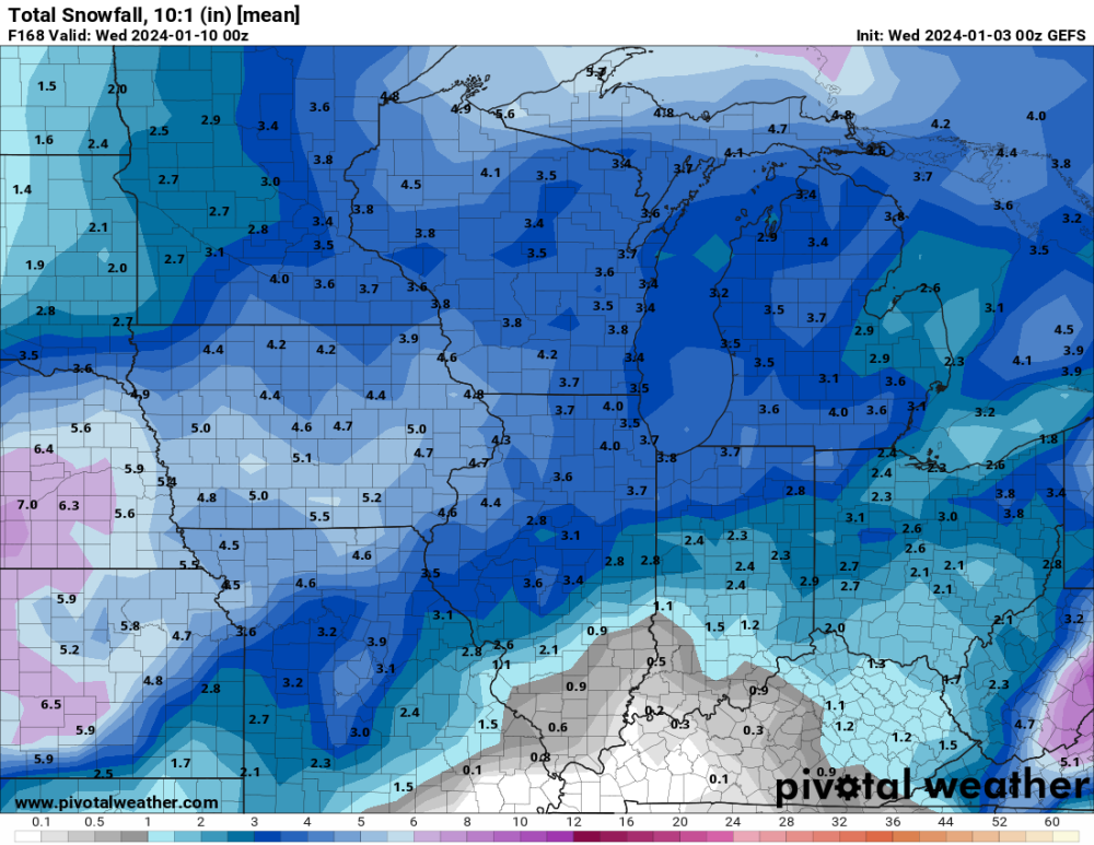
Going to be a really good run for Michigan peeps...
-
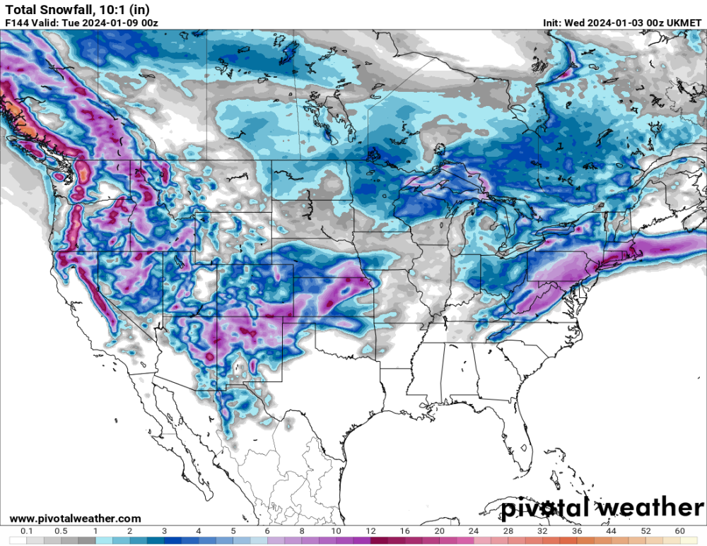
10:1-
-
Much better run for IA.
-
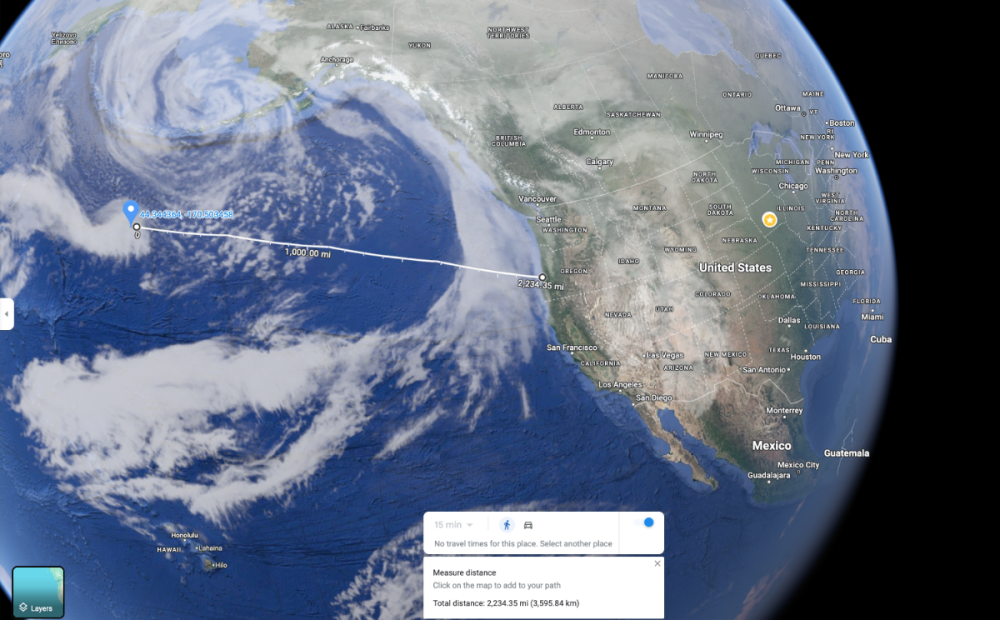
Pretty amazing when you think about it how good these models are-- even off 100 miles or so at this range. Location of system and distance to the Oregon coast. I know this is not where it will likely come ashore ( probably N of here ) -- but just gives one a better understanding of whats going on here. Baffles my mind.
-

January 2024 Observations and Discussion
Grizzcoat replied to Minny_Weather's topic in East of the Rockies
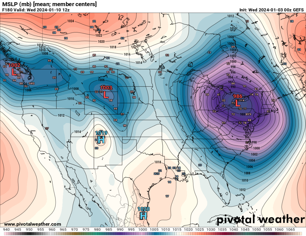
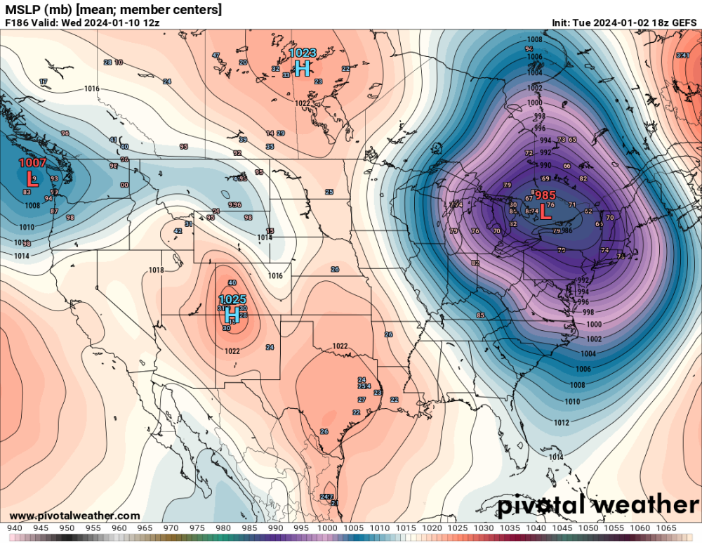
1062 High in W CAN at HR 234. -
January 2024 Observations and Discussion
Grizzcoat replied to Minny_Weather's topic in East of the Rockies
I know it's HR 231 on the GFS- but wow!-- this is maps I doodled in weather observer school!!! -
January 2024 Observations and Discussion
Grizzcoat replied to Minny_Weather's topic in East of the Rockies
NO matter the amount of snow from the first system- I'am looking forward to tracking the NEXT system while itis potentially doing something outside. (hopefully snowing) - haven't had that since last winter. -
January 2024 Observations and Discussion
Grizzcoat replied to Minny_Weather's topic in East of the Rockies
CMC for above system- (still snowing for many-- pivotal doesn't have 48hr snowfall and don't want to get confused with early week system) 24 Hr -
January 2024 Observations and Discussion
Grizzcoat replied to Minny_Weather's topic in East of the Rockies
System middle/late of next week looking more and more impressive with true arctic air to work with this time. Ratios should be higher.-- especially NW side. -
ICON at HR 135 vs12Z -- also quicker to arrive.
-
-
ICON N at HR 126 / compared to 12Z-- like 100 miles N
-
And now another flip flop the other way !!! GEFS lowering totals and S - GFS operational N and increasing totals. This thing is near the international date line right now!!! Sunday is a transition day between the approaching early week storm and the minor weekend event. Today the impulse that will become next weeks system is still well off in the North Pacific Ocean, roughly near 175W/45N and still 2.5 days from reaching Oregon Washington coasts of the Pacific Northwest by 12z Saturday. Not to underestimate the ability of models to forecast storms, this is still well outside the window of high forecast certainty for track and evolution. Just coming into view on his satellite loop. Think there will be deviations in the track? https://weather.cod.edu/satrad/?parms=global-npacwestlarge-13-24-1-50-1&checked=map&colorbar=undefined
-
I say this every year. And especially at this range outside 90 hours- 06Z/18Z GFS does not apply current upper air soundings. Why do you think the CMC/UKMET/EURO only run out past 90 hours WITH upper air soundings? Yes the argument can be made that the system is 6 more hours "closer" -- but what is 6 hours without "new" upper air data past 90 hrs? = probably a funky run past 90 hours. Just my .02
-
another jump or two like that N and it will be in SD/MN with L going right over DSM. Actually- that is what I think is going to happen.
-
Likely because for the most reading there has been very little to track. But yeah I agree- 144-168 out is FOREVER in weather forecasting. I still like my North call from day or so ago- and by N - I mean MN/WI and not my home here in IA. Just a gut feeling..
-
Variables that still need to be worked out are obviously numerous at this range. One that is clearly an issue is if true Arctic air will get pulled down right behind this system ? or - will the low pressure parade coming in from the NW USA limit it's intrusion? If the Arctic air is allowed down it will only make this system more dynamic but then likely shut down the low pressure parade for a time. You can see the GEFS struggling with this tonight--- 18Z and 00z Fun times ahead.
-
Not only N - but increased totals by about 25% compared to 12 and 18Z runs-- Go figure-
-
GEFS well N of it's operational run--
-
UKMET-