Grizzcoat
-
Posts
4891 -
Joined
-
Last visited
-
Days Won
16
1 Follower
Recent Profile Visitors
2923 profile views


Grizzcoat's Achievements
")


-
the bowing line means business
-
SPC has expanded enhanced risk further into C.IA for the early morning bowing line. They didn't use the "D" word but I'am thinking it will likely happen. SPC AC 240059 Day 1 Convective Outlook NWS Storm Prediction Center Norman OK 0759 PM CDT Thu May 23 2024 Valid 240100Z - 241200Z ...THERE IS AN ENHANCED RISK OF SEVERE THUNDERSTORMS FROM CENTRAL NE TO WESTERN IA... ...THERE IS A SLIGHT RISK OF SEVERE THUNDERSTORMS SEPARATELY IN PARTS OF THE SOUTHERN GREAT PLAINS... ...SUMMARY... Scattered severe thunderstorms are expected across parts of the central Great Plains and Mid-Missouri Valley through sunrise. A swath of damaging winds with gusts from 70-90 mph is most likely across central and eastern Nebraska into western Iowa. Isolated intense thunderstorms remain possible this evening into tonight across parts of the southern Great Plains, including a few tornadoes and very large hail. ...Central to northern Great Plains... Large hail and a few tornadoes have been the primary reported hazards thus far with scattered to widespread thunderstorms from far southern ND into western NE. While the storms over the Dakotas are expected to weaken after sunset, pronounced MCS development appears probable tonight through tomorrow morning across NE into IA. The current tail-end supercell complex, just west of North Platte, should grow upscale into a bowing MCS. This will be aided by rapid strengthening of the low-level jet over KS/NE to 60-70 kts during the next few hours and a downstream plume of moderate to large buoyancy advecting quickly northward across the Mid-MO Valley. While low-level instability, especially with northern extent, should remain weak, the strong forcing for ascent and abundant MUCAPE will be favorable for a swath of severe wind gusts. Recent HRRR soundings indicate a rear-inflow jet to around 80 kts, suggesting that gusts from 70-90 mph should be anticipated as the bowing MCS matures. Have expanded level 2-3/SLGT-ENH threats farther east-northeast in IA to account for potential severe winds persisting through 12Z.
-
Nasty


-
HRRR and to lesser extant RAP showing derecho potential early AM Friday for W/C IA. DMX talking early AM tornadoes on S line-- National Weather Service Des Moines IA Issued by National Weather Service Quad Cities IA IL 221 PM CDT Thu May 23 2024 .KEY MESSAGES... - A potentially large MCS is expected to move through Iowa tonight. - Severe weather is possible, with the primary risks being damaging winds and large hail, but tornadoes are possible as well, especially in the southern end of the QLCS/squall line.

-
 Minden,IA tornado close to EF-3 when it entered town but clearly intensified on NE side --- seen in both videos here below.
 -
Sadly it's been confirmed one person was killed in Minden. From what I saw first hand, that is a miracle.
-
Minden,IA- 5 min after the tornado. (LONG STORY on how we even ended up here)
-
My crew was 5 minutes behind this footage.
-
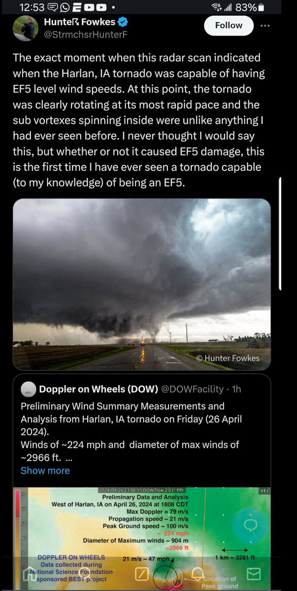
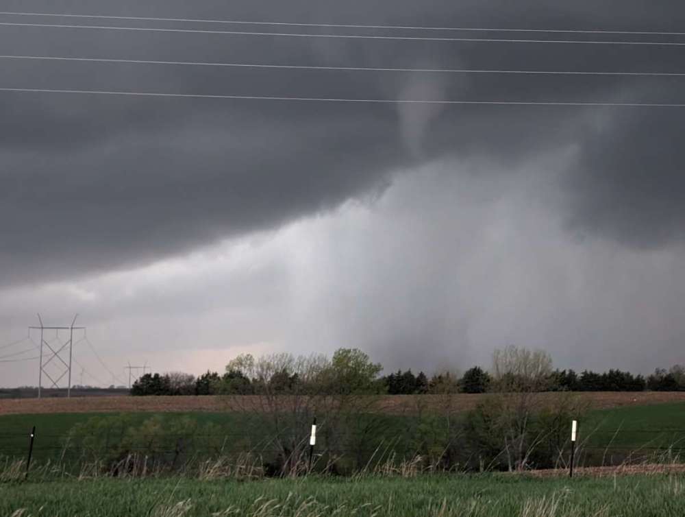
One of 10 tornadoes I saw on 4/26-- the Minden ( well on the ground before) to Harlan,IA may be rated an EF5.

-
Right one went wedge and hit Minburn. Saw at least 7 tornadoes and saw 2 tornadoes together twice. PXL_20240426_222456152.mp4
-
We went and checked out the Pleasant Hill area after it moved through. Loss of power for many, minor debris and heard of one injury. If that's all, they lucked out.
-
PXL_20240427_005002389.mp4
-
Absolutely crushed it today chasing. Will share more later but here is the Minden IA twin tornadoes before it wedged out. 2nd one was near Lorimor Ia Unreal day. Sadly saw Destruction in Minburn
-
Will Chicago receive more snow than Minneapolis this winter?
Grizzcoat replied to Hoosier's topic in East of the Rockies
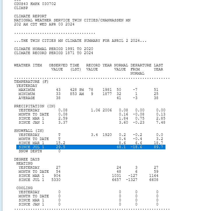
Yeah not even close. Through April 2nd- both exactly at 60% of normal.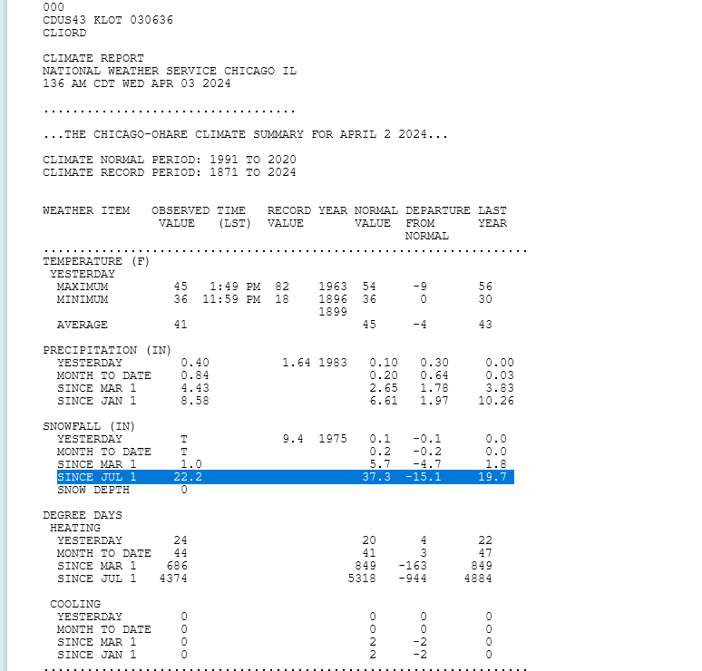
-
The Total Solar Eclipse of April 8, 2024
Grizzcoat replied to Hoosier's topic in East of the Rockies
Not sure if anyone has posted this yet but Pivotal has it's own dedicated page to the eclipse for clouds in ensembles. https://www.pivotalweather.com/eclipse2024/?m=cmceens&p=cloudcover_tle_4-mean&r=conus