Black Hole
-
Posts
2734 -
Joined
-
Last visited
-
Days Won
1
Recent Profile Visitors
3054 profile views


Black Hole's Achievements
")


-
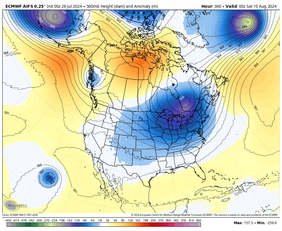
Here are some maps for ~Aug 10th with the EPS showing a trough signal and the AIFS maybe a better example of what it could look like. It definitely appears we will be cooking in a few days but it's not going to last with another cool down on the way. These troughs are being a real life saver this year.


-
Makes sense! From my perspective Payson has the most laid back feel of those areas but the lower elevation cuts you out of some snow/monsoon activity. Pinetop/lakeside doesn't seem as snowy as Flag either but they do get a lot of monsoon action.
-
I love it up there in the monsoon season. It's cool in the morning, storms bubbling up by noon or so, and then rain cooled 60s-70s by the evening a lot of days!
-
As I recall storms are least likely in the early afternoon, say noon to 4 pm, which is the opposite of a lot of places. Of course Tulsa is 'backwards' too with most of our warm season storms 1-7 am or so. Pretty annoying really
-
Big time heat will be returning to the area next week. Luckily the core of the ridge probably centers closer to the Rockies but highs up near 100F are likely with dew points in the 70s. The only good news is I don't think it'll last long with this baggy trough over the TX/OK/LA/AR area likely returning late in the week 2 period to knock us down to normal again.
-
The late storms is very much the norm around there. I remember looking at the stats once and during the monsoon the peak window was like 9 pm to 1 am with a max at 10-11 pm. You'll have to stay up if you want to see much.
-
We ended up with just under a half inch of rain at my house yesterday and a high of 82F. 69F this morning. We have another 2 days in the 80s then its back to low 90s for a few days. It's been a wonderful break and I am not ready for it to end, but we will start to see this more often in just 6 weeks or so.
-
That's not a part of the valley known for dust storms. Most of the dust storms are in the southeast valley from outflows coming up from Tucson. The reason being that is where there are empty farmers fields and lots of loose dust. Impressive either way.
-
Biden finding out he dropped out watching the news tonight:

-
Reached 73F here not long ago with a good heavy rain. Great weather for late July!
-

Dubai Heat Index 150*
Black Hole replied to Andie's topic in Climate, World Weather, and Earth Sciences
It seems like it's at it's very worst there around 8-11 AM every day. This is before the morning inversion can break up so although the temperature isn't as high the dew point reaches its max. I've been watching some of the stations over there with dew points as high as 91F and as you noted heat indices exceeding 150F. -
.31" here overnight from storms. More in some spots. It'll be a cool day for summer today. Our next chance of rain is in about a week. Temperatures look to remain below normal for the next week before getting warmer next week.
-
Most of our big wind derechos are in May or June during "MCS" season as we get these wind/rain bags that roll in from the northwest. That was the way we got our big wind last year too. We can get windy squalls all summer in the same fashion but they need good flow (unlikely in summer most of the time) and big instability (hard to do in winter or early spring).
-
I had a low of 63F at my place this morning, with dew points as low as the upper 50s. What a reprieve. Today looks quite reasonable. Moisture surges back tomorrow but with rain possible through Monday or maybe Tuesday it'll be fine.
-
Our peak summer averages are 95F and 74F which we reach July 24-31. We are almost there!