Grizzcoat
-
Posts
4887 -
Joined
-
Last visited
-
Days Won
16
Everything posted by Grizzcoat
-
-
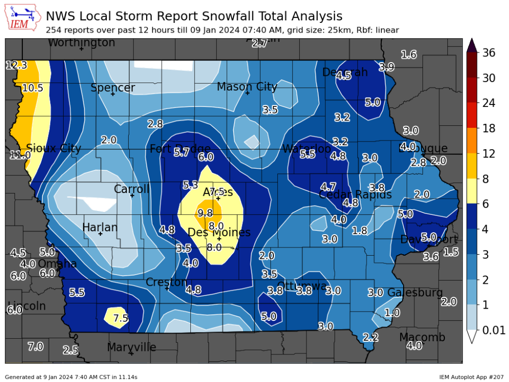
Maybe- but that band I mentioned earlier and posted a radar pic did this-- and still snowing. Some these places will be near 1' also-
-
29.14 Altimeter just E of STL. That's like 987 MB SLP don't recall guidance showing pressure that low.-- at least from yday
-
PXL_20240109_122813442.mp4
-
Flake size change. PXL_20240109_122802092.mp4
-
I got a a few more videos- 2nd one coming is nuts
-
Roads were crap here in Des Moines area last night 11pm. Only 2-3" at the time, but the 32F temp made things ultra slick. Even in 4 Wheel / felt like 2 wheel. Experienced winter driver. No plows so it was rutty and threw you around even in full size pickup. Probably didn't help I was doing 55mph on I-235-- but hey- got to get to work on time!!!
-
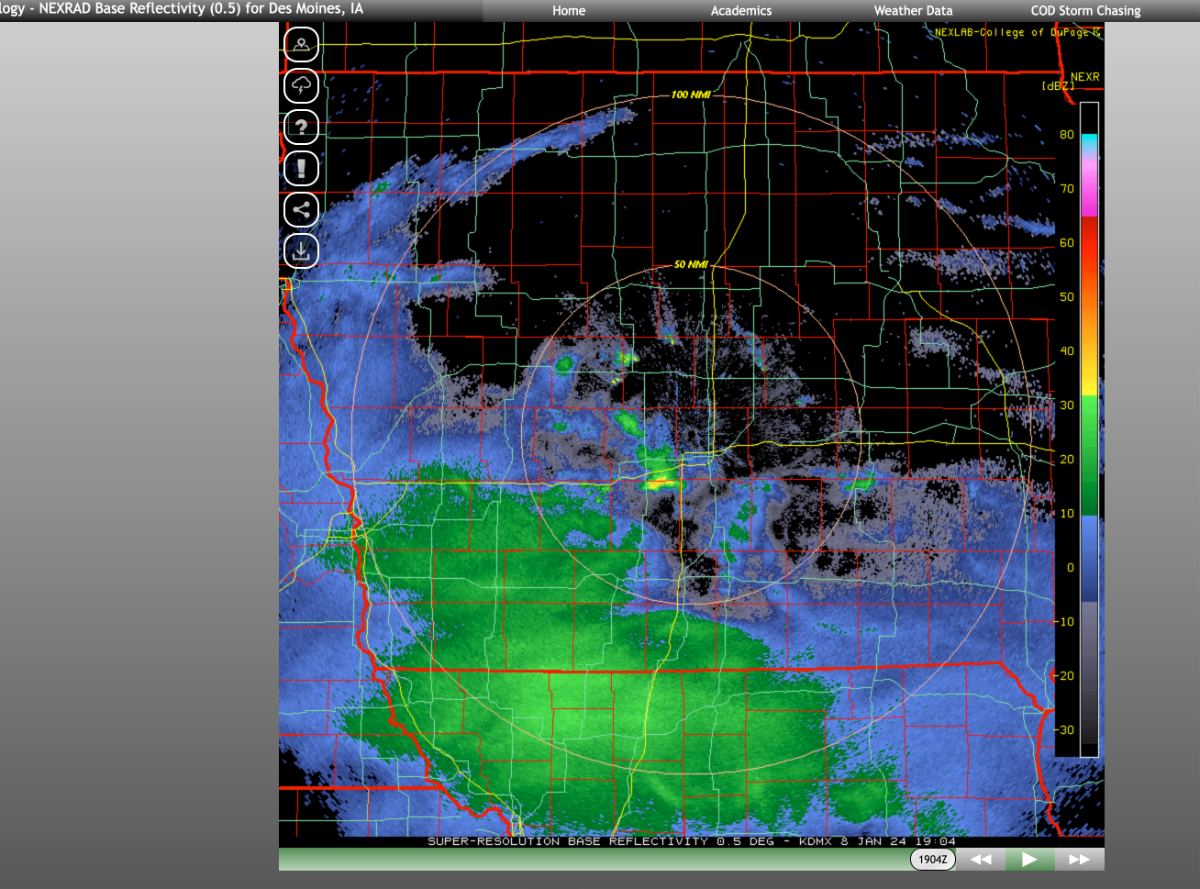
This sat in same general area from 2-4AM-- radar is from 3AM---
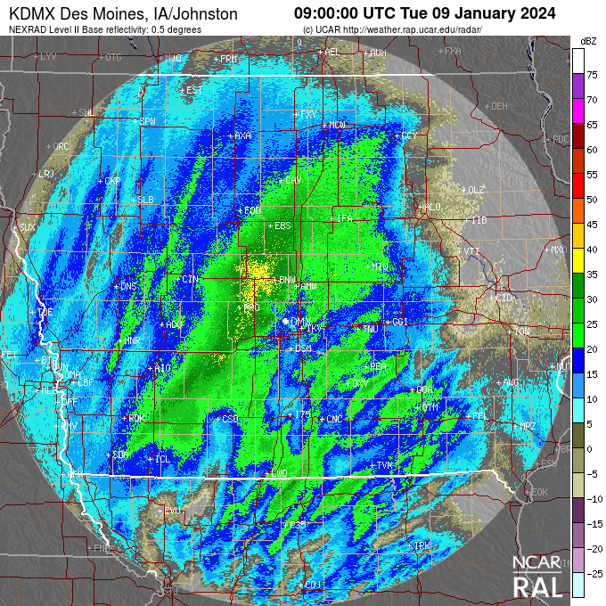
-
Heavy Band from Perry to Ames from 2-4AM -- bet there is 8-9" there right now
-
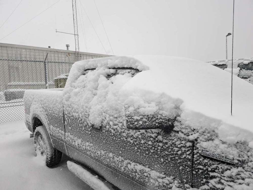
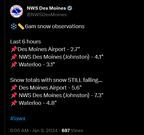
It was heavier then this 5 min before I grabbed my phone. DSM Airport 5.7" event total through 6am. PXL_20240109_114942946.mp4
-
DMX not backing down as much as I thought-- must be banking on the defo band cuz this WAA band sucks-
-
DMX downplaying which makes sense-- TS south are robbing moisture. But does mention the "B" word. Donavan is a very good forecaster. fwiw. Good Luck to those East! FAQ Comments... Area Forecast Discussion Issued by NWS Des Moines, IA Home | Current Version | Previous Version | Text Only | Print | Product List | Glossary Off Versions: 1 2 3 4 5 6 7 8 9 10 11 12 13 14 15 16 17 18 19 20 21 22 23 24 25 26 27 28 29 30 31 32 33 34 35 36 37 38 39 40 41 42 43 000 FXUS63 KDMX 082100 AFDDMX Area Forecast Discussion National Weather Service Des Moines IA 300 PM CST Mon Jan 8 2024 .DISCUSSION.../Tonight through Monday/ Issued at 256 PM CST Mon Jan 8 2024 Key Messages: - High impact winter storm event for the area through Tuesday - A quick hitting light snow on Wednesday - Another potential winter system around Friday - Arctic cold arriving this weekend Intense low pressure system is located over the Oklahoma panhandle this afternoon with an inverted trough extending northward into the Siouxland. Heavy snow has already occurred on the west side of the inverted trough including the Sioux Falls area. The theta-e advection band lifting to the northeast of the system is leading to an area of snow lifting into southwest and central Iowa. Overall general model guidance is running slightly too warm at the surface leading to too warm of wetbulb temperatures, suggesting a mix of rain/snow through the rest of the afternoon though thus far all precipitation in the region has been in the form of snow. The area of low pressure will move east this evening then will lift northeast towards St. Louis after midnight. Expect the theta-e advection snow to lift through the area with the potential for a lull then a transition to deformation snow. There remains a lot of uncertainty with this system as there will be a vast amount of convection in the warm sector of this system to the south of Iowa. What impacts this has on the amount of moisture that is available in the cold sector is in question and at the very least, it should result in some disruption in the moisture lifting north in the warm conveyor. In addition, the forcing into Iowa is "messy" and not focused through a good dendritic layer as would be preferred for a very heavy snow event. The current regional radar is very splotchy and does not contain a large homogeneous region of good snowfall rates. Snow crystal morphology is not clear as well with broad generally modest forcing through a large layer of the column and through broad temperature range. Utilizing the Cobb method, it makes selecting a dominant crystal type and thus snow ratios difficult and generally will blend down to something near the 13 to 1 climatology. While there will be periods with dendrites and higher ratios, the increasing wind of greater than 20 kts tends to reduce SLRs by 25% and higher winds can lower it further due to crystal fragmentation. A study by NWS MPX also shows that snow events with 0.5" or more of liquid precipitation typically results in SLRs closer to 10 to 1. Overall, suspect that snowfall totals as an area, are too high, perhaps by several inches. There is some chance for slantwise convection with CSI present that could lead to the higher amounts by the chances for a widespread 10+ inch snowfall with a messy system like this is not common. On that note, CAMs are very hot on QPF with this system an are now driving higher NBM totals. Again, the CAM output is quite likely not realistic. Blowing snow is another aspect as the cold advection arrives on Tuesday. With the strong cold advection, good momentum transport of max mixed layer winds typically occurs. The max mixed layer winds are in the 30 to 35 kt range, which in itself is not great for blizzard conditions. The pressure gradient across the state is high though and is approaching a magnitude of 50 ubars/km and could help the wind to eclipse the max mixed layer wind. Will need to monitor this in case the wind gusts do start to eclipse 40 kts as that would help push near blizzard conditions.
-
18Z RDPS-- after some time it becomes futile with these models. You most simply- like back when I as D1 athlete == execute your potential. Maybe why the NWS is good coaches?
-
Does seem NW trend in IA with 3Km NAM-
-
Dang- what a beast- getting some bouns snow here as no model had SN here yet-
-
i think you peeps over there will do better. But - for sure - trends down along I-80 to DSM. But I don't trust HRRR/RAP past 6-9 hours as clintbeed said. He is right on. Why people post HRRR / RAP maps out so far is beyond my pay grade. Stick with radar now. And Common Sense. Hope you do well!!!
-
Temps have not moved here at my locale in last hour or so. 32.5F. -- HRRR and RAP have progged 35-37F here in 20 minutes. Just need the precip to start here. I'am banking on it being all snow (as is the NWS) and not with HRRR / RAP which a good inch of snow is wasted to liquid.
-
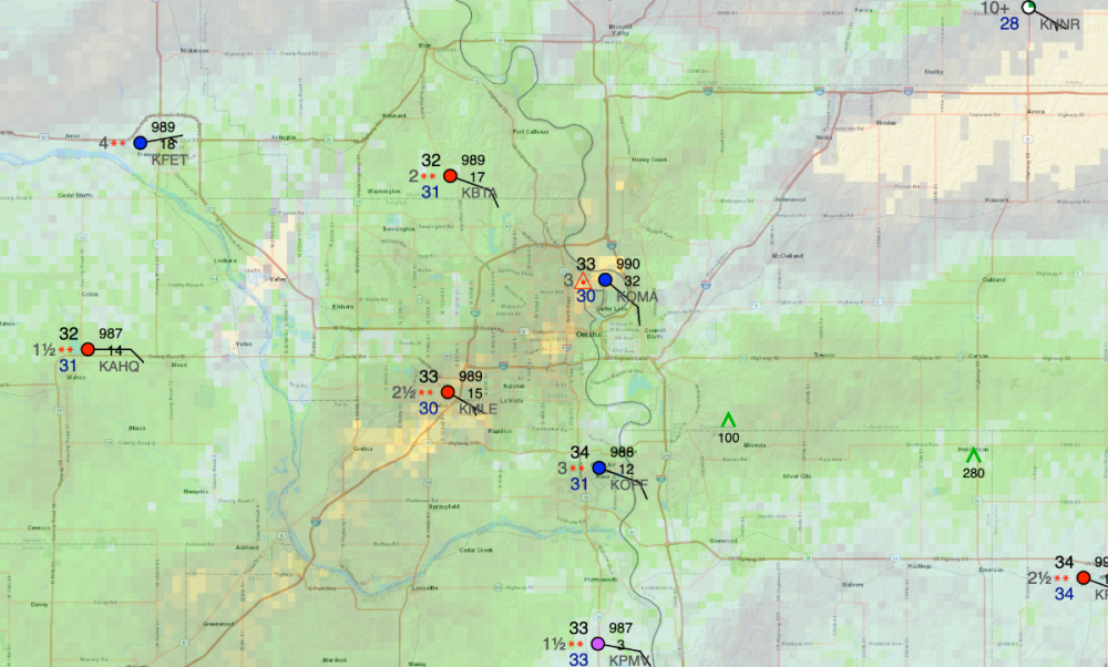
OMA with the dreaded ping feast.
-
Not so sure I by this for C.IA- NBM- 12Z (if it's a blend what is it seeing that the GFS/NAM/NAM 3KM aren't) -- with those lucky to get 4-6" - but this 7-9" - go figure.
-
Have to be honest- HRRR and RAP have me nervous, they have initial surge as -RA, which eats into snow totals. NWS basically discounted this in the AFD, but man, never know for sure until it's happening. ICON is not wavering here in Iowa- but gives MO peeps more snow.
-
Congrats to Hawks12 in Sioux Falls-- 6" all ready!!! KFSD 081156Z 08009KT 1/2SM SN FZFG VV009 M05/M07 A2996 RMK AO2 SLP169 SNINCR 1/6 4/006 P0009 60043 70043 T10501072 11050 21056 55009 RVRNO
-
What is up with the row of counties on the border between KS/OK with no hazards? It's not like its not windy there- but I guess someone decided they didn't warrant it cause its freaking windy there all the time Just a little odd.
-
As I mentioned earlier; the amount of wind advisories is incredible. And obviously; many areas would have them if not all ready covered by a Blizzard/Winter Storm Warnings etc. At least 1/3 of the lower 48 would be covered if you factor the above in.

-
-
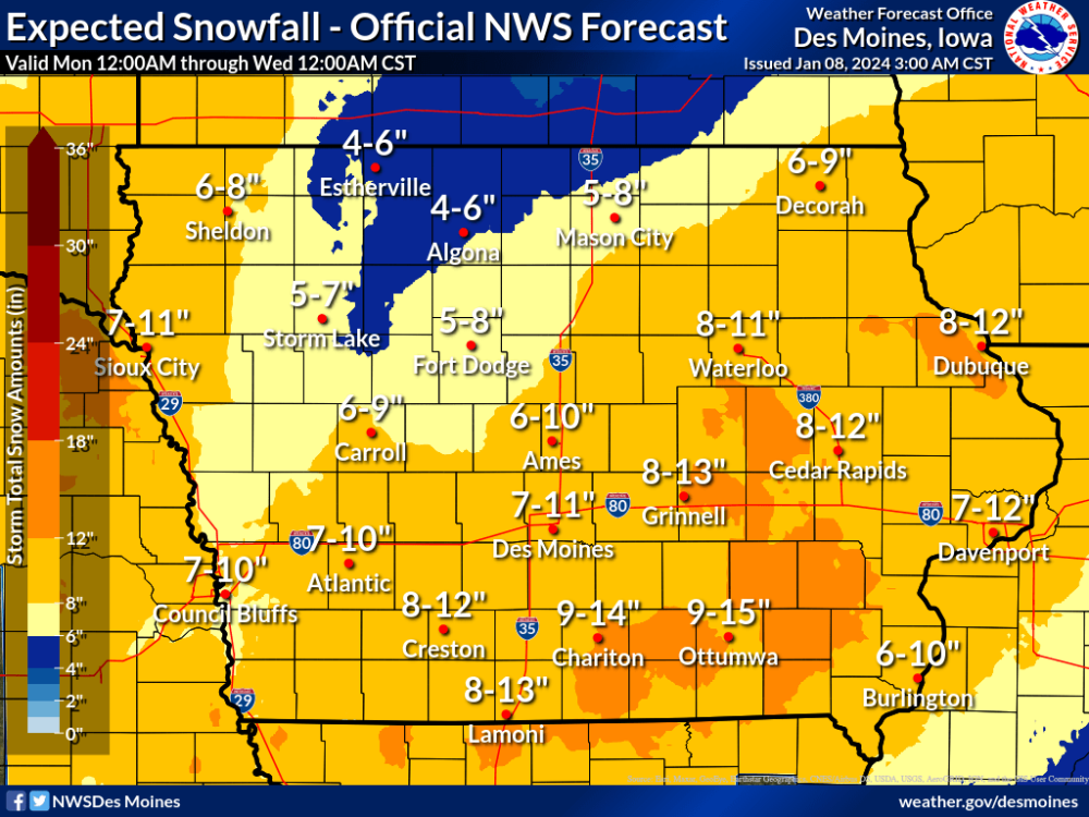
DMX talking potential of TSSN. Winter Storm Warning, and 8 to 12" through the rest of the area, with the highest amounts in southeast to east central Iowa where probabilities of 30-50% exist for snowfall over 12". This is also the area where guidance continues to highlight the potential for snow rates of 1-2" per hour at times. These higher snow rates of around 1"/hour may extend back towards portions of central Iowa at times as well. Cannot completely rule out the possibility of some thundersnow forecast cross sections indicating some negative EPV with forecast soundings also indicating some elevated instability at times.