


Skagit Weather
-
Posts
2303 -
Joined
-
Last visited
-
Days Won
3
Posts posted by Skagit Weather
-
-
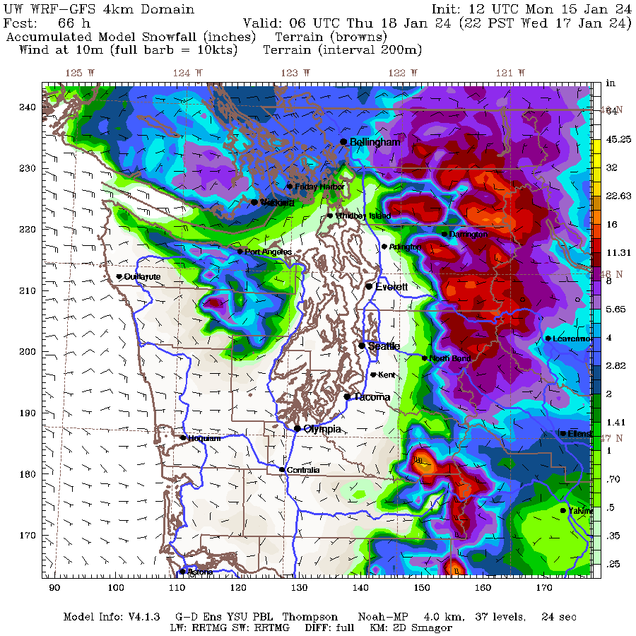
Anyone have the snow total for the HRDPS?
-
 2
2
-
-
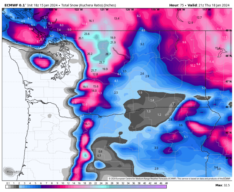
33.4/16.7F day here and back down to 24F. The GEM is truly embracing its name tonight. It shows 18" (12" Kuchera here). Maybe the 00z Euro will come around to join the party.
-
1
-
-
6 minutes ago, TT-SEA said:
00Z ICON has updated.. very slight shift south.
That slight shift south gives me 3 times as much snow.
-
2
-
-
14 minutes ago, TT-SEA said:
It's so darn close! Maybe this is going to be like February 2014 where I had like 2.50" of precipitation that all fell as snow/snowrain while a couple miles to my north places got buried. I got 1-2" of snow/slop out of it, but I was so close to almost 1-2 feet of snow. The temperature was stuck at 33F for two days straight.
-
 1
1
-
-
Up to 27F currently. Yesterday we saw another 6 degrees of warming after 10:30 am so it might be close whether I can pull off a 4th sub-freezing high, but the high clouds might keep temperatures down a bit. Probably will end up with a high around 34F if I had to guess.
-
1
-
-
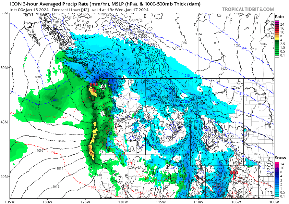
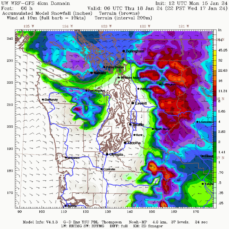
12z 4km GFS-WRF had about a 10-15 mile shift south from the 00z, but still shows snow basically only Whatcom County north despite the more favorable GFS.
-
1
-
-
Is this actually going to happen? I'm becoming more optimistic, but I not going to believe it until I see the pepto of the Euro's eyes.
-
9
-
-
Definitely just a bit of variation in the models for my location. They show anywhere from 0-15" of snow in the next 3 days. I would really love the RGEM to verify because that's by far the best one for up here, but I don't love that the Euro is so opposed to any snow here.
I had a low of 16.7F last night after a 29/14 day yesterday.
-
3
-
1
-
-
4 minutes ago, Chewbacca Defense said:
You can see your breath?
In all seriousness though I'm with you, it sucks to have this kind of cold and have bare ground. I love the stats, but I love snow more!
I actually couldn't see my breath when the dew points were so low. With dry air seeing your breath relies on condensation and with temperatures 20 degrees above the dew point that was significantly harder to achieve. Now I can though, with my DP/Temp spread only 3 degrees.
-
1
-
-
23.6F for a high today after a low of 11.6F. So a couple degrees warmer than yesterday for both the high and the low, but it was still my 5th coldest day I've recorded on my station since 2008 (all of which have happened in the last 25 months). Currently 14.9F maybe heading for a low a degree or two colder (if I'm lucky). I'm hoping that I can stay below freezing for one more day tomorrow because it would be nice to have 3 subfreezing highs, but with mostly sunny conditions and moderating cold it might be a challenge.
I'm cautiously optimistic about the slight southerly trends in the models over the past day for the Tues/Wed storm. Still think it's going to manifest as quite a bit of cold rain, but at least there's a chance up here to get something other than cold temperatures.
-
3
-
 1
1
-
-
2 minutes ago, Rubus Leucodermis said:
10.0 here. Was colder a couple hours ago.
Most of the models showed this happening with temperatures staying pretty constant throughout the night. Still hoping I get to see single digits, but with the temperature warmer than it was 4 hours ago I'm not optimistic.
-
1
-
-
Just now, GHweatherChris said:
This link doesn't let me just pull up the simple all time low temp, it does avg max/min, which is weird.
Yeah, you just gotta select one day instead of multiple days.
-
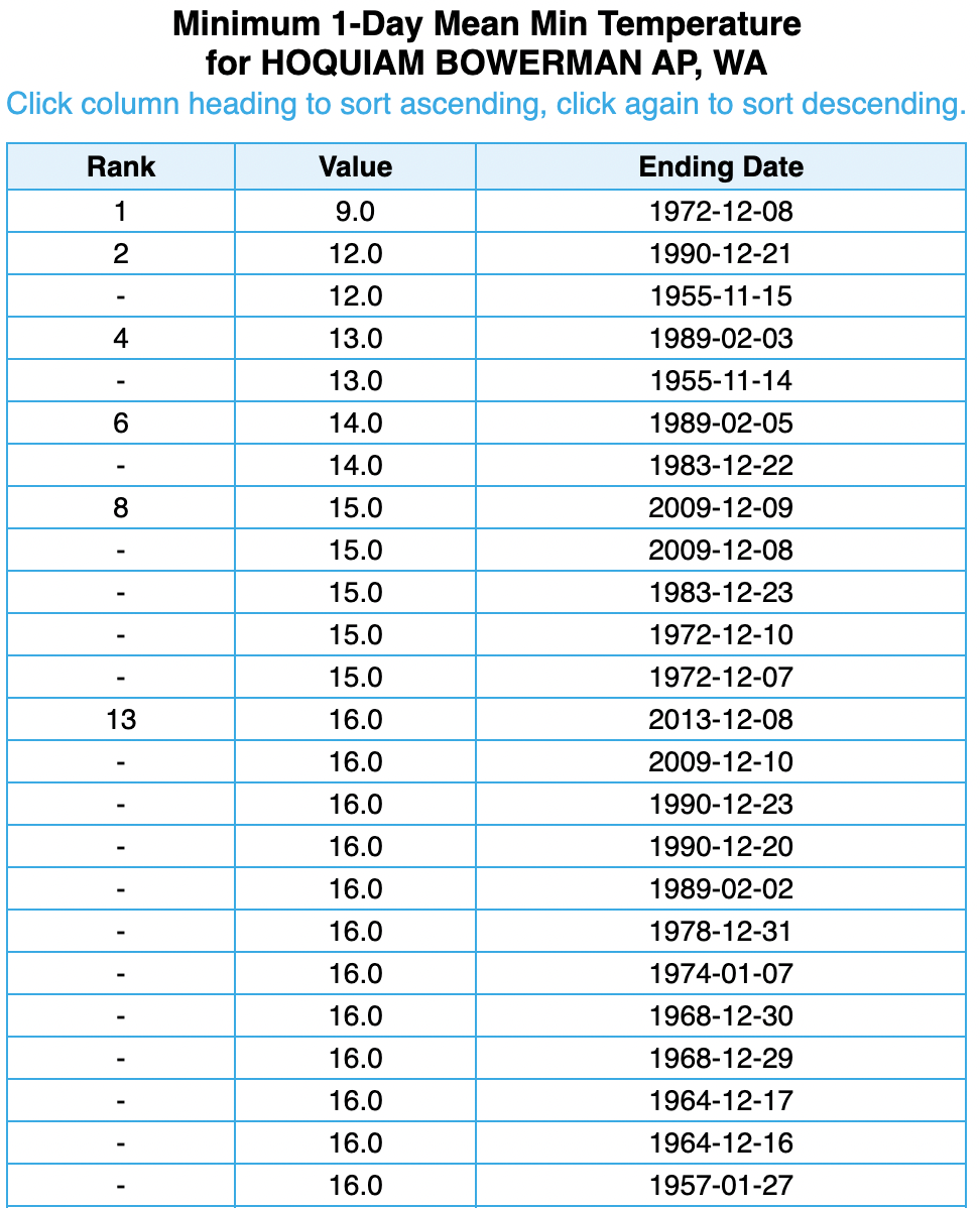
3 minutes ago, GHweatherChris said:
I don't know lol, I wanna look up what Hoquiams all time low temp record is.... can't find or figure it out.
Here you go with records going back to 1953:
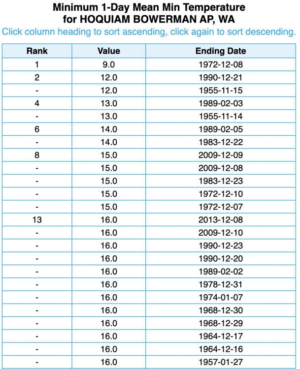
-
3
-
-
1 minute ago, GHweatherChris said:
Ok, does anyone on here now have a link to a site to look up a locations all time low/high temp including data newer than 2010?
You talking about this one?
-
1
-
-
13.1F currently after a daytime high of 18F. Unfortunately my midnight high was 21F so that is what will go down in the records.
Most mesoscale models don't show it dropping very much from where it is right now, but the Euro shows we maybe have another 5-8 degrees to go so I'll stay optimistic. Today was impressive, but didn't quite hold up to December 27, 2021. On that day we had a daytime high 1 degree colder and a low of 6.7F. Of course I had almost 10" of snow on the ground at that point so who knows what the temperatures would have been without snow.
Going forward I think that will end up being the question from this event: how much colder could the temperatures have been with a widespread snowstorm going into it? But oh well, cool to be experiencing this event in real time.
-
4
-
 1
1
-
-
All-time record low temperature at Ross Dam this morning in the heart of the North Cascades. Low was -3F which beat out the -1F from January 1, 1979. Records have been kept since 1960.
I feel like the record low should be significantly lower than -3F considering its location in the Upper Skagit Valley, but maybe it doesn't generally decouple enough during these cold snaps to lead to really cold temperatures.
-
4
-
-
Just now, Rubus Leucodermis said:
? There are two digits in the number 10 (or 11, which 10.6 rounds up to).
Yeah, I said I wouldn't get down to the single digits and I didn't because my low was 11F.
-
Temperature dropped to 10.6F this morning so I wasn't wrong last night when I said that we wouldn't reach single digits, but it dropped better than I expected. This is my 4th coldest Arctic blast I've recorded on my weather station (since 2008) and the coldest without snow cover. I think it would feel more special if I hadn't had single digits the previous two winters, but I'm not complaining. Car wouldn't start this morning so I had to jump it before heading off to work.
Tonight looks like it will be nearly as cold if not a little colder. Obviously colder down south, but it's less clear up here. The Euro/GEM forecast temperatures a couple degrees colder while the GFS/NAM is a bit warmer. Would really love to see single digits, but not sure if that's going to happen. High at midnight was 21F, but I think we'll get warmer than that during the day. Probably hit 23/24F today.
-
3
-
-
Currently 23F here. I have to say this is probably the least impactful "big" arctic front that I can remember. To be fair I usually get almost no wind so the biggest impact is snow, but the very slow drop of temperatures without any wind or snow makes it feel like a normal cold winter day. Most people up here in Skagit went to work and when they got back if was a couple degrees colder than when they left in the morning so they probably didn't notice a thing.
Forecast up here is for 9F by morning. Based on the rate of temperature drop I just don't see it happening. Maybe mid teens, but I would be surprised if I get much colder than that. Tomorrow will probably over perform on high temperatures as well.
-
 2
2
-
1
-
-
Okay, here we go with the temperature drop. Down 4 degrees in twenty minutes to 29F.
-
1
-
-
Outflow has started shredding precip blobs as they try to move across the strait. Meanwhile, the Chuckanuts are doing a great job at blocking the cold air. Temperature remains above freezing although places to my south and west are significantly colder.
-
1
-
-
Light flurries and 34F at the moment. Seeing some promising returns north of Victoria at the moment, but think they'll probably be pushed south if they try to make it across the San Juans. Temperature is actually up a degree from half an hour ago.
-
6 minutes ago, Rubus Leucodermis said:
So far, NAM 3km and HRDPS have absolutely nailed it up here.
NAM 3km was about 4 hours too quick with the arrival of cold air. Can't really make any judgements about snowfall yet other than it was correct that nothing has fallen here.
-
2
-
-
A couple of very sporadic 40F snowflakes drifting down now.
-
1
-

January Weather In The PNW 2024 (Part III) - The Warming Shot
in West of the Rockies
Posted
Yeah, the high resolution one you just posted (which I believe is the 2.5km). Just interested in what it shows up here for the end of the run.