


whatitdo
-
Posts
146 -
Joined
-
Last visited
Posts posted by whatitdo
-
-
15 minutes ago, Stacsh said:
I'd go with trends. Always. And the trend is not our friend. Everything past 10 days showing cold has not panned out this year up to this year, why would it change now?
lol no reason it would change at all. Honestly probably won't look at any model forecast past 120 hours. Seems like the more attention paid to the long range, the more likely it doesn't pan out. I'd rather just be more or less surprised in the 5 day time frame rather than anticipate a change >5 days out only to be disappointed. Grateful for the long range forecasters here and abroad in their success for predicting potential storms/cold and their time frames, but location on where it tracks is the extraordinary challenge - only mother nature herself truly knows ya feels
-
 5
5
-
-
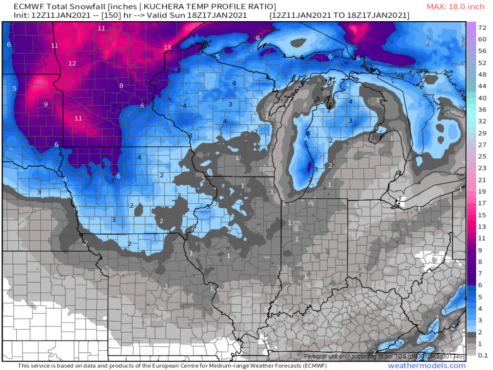
For midwest/great lakes region though, GEFS and GEPS do not agree; in fact they are very different especially in 1/25 - 1/29 timeframe. GEFS with a lot of positive snow depth change; GEPS with minimal and maybe even less snow depth change. Bets on which one plays out?
-
31 minutes ago, Tom said:
This lil beast is going to look like a "mini cane" on radar...incredible dynamics with this storm...it's going to sit and spin over E IA for like 20 hours. I wouldn't be surprised if we see an intense snow band right near the SLP similar to an eye wall. Wild stuff!
wow what a winter to remember for the iowa/minnesota peeps in the sub! System looking awesome
-
4
-
-
7 hours ago, jaster220 said:
Has to be wrong then

Was correct - congrats Indy!
EDIT. Kinda important you say which run of a model you're referring to. I see it must've been the 18z as the 12z was a rainer, and the 14/0z is a whiff south. Either are more likely than a direct hit imho. Nice try tho. Can you wake me when a decent snow is knocking on my door, not on a single Op run beyond 200 hrs?
Why do we keep getting whiffed on significant snowfall smh. Even GRR is underwhelmed that all our chances for snow for next 7 days are light and add up to 2 inches at best.
-
24 minutes ago, Grizzcoat said:
whatitdo-
I will respond once to this thread and that will be it. First off- not a degreeed MET, but i have been pretty much grandfathered in with my job as one and work with several. Most MET's actually agree with Climate Change, but how is the question. Most MET's DO disagree with AGW (man made to the extent it's shown in the media) but will revert to "I agree" or they suffer "set backs' in their career. Trust me. Seen it happen many times on the broadcast MET front with many tv people let go because of their beliefs agst full out AGW. If you want a list- I can provide it. Many i know personally. I could go on and on and on about many data points that point to a natural variation in climate being induced as AGW- one is urban heat island, but I know - that of course gets thrown out. I understand why- but no way is DSM IA going to break the all time min of -30F set on JAN 5th 1884 when official measurements were taken in river valley. If FEB 1996 didn't break it(-26F) at the Airport - with all time record lows set in MN,IA,WI (-47F in IA) nothing will. My point before I leave is that it's not apples to apples when you compare temperatures from even 30 years ago. Enjoy you day- but this is the last post I will have this topic in this thread. Peace out.
no worries my man i sincerely appreciate the input. We could discuss the AGW stuff in another thread sometime if that were to happen. FWIW I do agree there is an amount of unfair and lazy comparisons about this topic in the sense you have alluded to on both fronts. Have a good day as well!
-
4
-
-
13 hours ago, Madtown said:
Ah yes let's all get on the bandwagon of censorship. I come here for weather not this trash. Silence all opposition, then your right. Anyways pattern change coming?
Saying fishel's post was "trash" and getting all worked up about censorship/silencing opposition is an overly defensive take. He's clearly talking about backing up what people are saying with facts. I think any reasonable level headed person, including everyone on this board, can appreciate that. Could he have been nicer...sure. But that doesn't take away from the valid points he's making.
Maybe i've missed something but idk why people get so guilt laden over this topic as if not the vast vast majority of meteorologists and atmospheric scientists agree global warming/climate change is real. On that note I think we should have a climate change thread or something instead of clogging stuff up in here
-
1
-
-
GRR says this system is meh at best and also meh for future snowfall into next week other than lakeshore areas.
-- Transition from rain to snow late Thursday into early Friday --

The models look like they have to come into a good consensus that
precipitation with the Thu/Fri system will start to develop over the
area later Thursday afternoon. This precipitation should start out
as mainly rain for most of the area as the lower levels will start
out above freezing up through 850 mb. This will not last long
however as evaporative cooling will occur, and turn any rain to snow
up north, with the south holding on to rain a little bit longer.

It does look like we will not see significant precipitation ahead of
this system, keeping snow accumulations in check. The limited
precipitation will be a result of limited Gulf moisture being drawn
into the system before the front moves east of the area. There could
be a couple of inches of snow across Central Lower, but it could be
much worse if better and deeper moisture was in place. All locations
will gradually see any rain change over to snow as the cooler air
moves in.

-- Cooler Friday through next week with occasional lake effect
chances --

There has been a decent amount of consistency in showing we will not
see significant amounts of precipitation, lake effect or synoptic,
after the front moves through. We will miss out on the deformation
snow on the NW side of this system. The air coming in in not all
that cold, only around -6 to -8C. This is not really sufficient
instability for lake effect. We will see a few snow showers, with
maybe some lake help, but nothing significant, especially by mid-
January standards. The snow showers will be more associated with the
filling upper low overhead.

Once the upper low gets kicked out, we will see the NW flow somewhat
similar to the current pattern gain control of the region. The
difference between the current pattern, and the one that will take
place on Sunday, is that colder air will be available. We will
continue to see short waves move through, but they will have more of
a potential to bring some lake effect snow showers along with light
synoptic amounts.

Overall, we continue to not expect a significant amount of snow in
any one location in a short period of time over the next week. We
will see the snow pack build up, especially near the lakeshore, as
we see a couple inches fall at times from Friday through next
Tuesday.
-
 1
1
-
-
48 minutes ago, Niko said:
Me as well, but the bad news is that the Euro weeklies are advertising a mild February. Not too sure what to think of that.
saw that too - would effectively be the nail in the coffin for this winter if it comes to fruition in terms of being one of the least snowiest on record for west michigan. What might save you from that fate is the slightly above snowfall you received on the front end this winter if im not mistaken
-
1
-
-
8 minutes ago, Hawkeye said:
The Euro is nothing like the UK. East-central IA gets crap on the Euro because the center of the upper low parks over us. The UK is probably bogus.

we can always count on Mr. No for his input. I wanna just toss it
-
28 minutes ago, Stacsh said:
Storms are great and all, but all you need in SW MI is some shortwaves with a little moisture and cold air. The snow can really pile up without any real storms. Models don't pick up LES snow very well in the long range as well. So if the pattern changes like advertised we will do well in the upcoming weeks.
thats very reassuring lets gooooo!
-
 1
1
-
-
47 minutes ago, OKwx2k4 said:
GFS starting to show where we're headed....FINALLY! I knew all that cold wasn't going to run off the EC. Hasn't happened yet in 6 months, not gonna start today.
")
@Grizzcoat May have a little LRC in it. (I don't call my process that or by a name, really) Looks just like December. Winter's back.

I just hope we score a storm here. I think I may stop model watching or something in order to make sure it happens
-
1
-
-
1 hour ago, Stacsh said:
Yes. Something better than what we have now. But nothing to excited about. It seems this winter is moving fast towards spring. This forcaster was promoting cold and snowy the last few days and now almost sounds dejected realizing that the mid-long range is once again proving to be fantasy.
Lol i noticed his optimism last week too. Reality bites!
21 minutes ago, jaster220 said:Yup. As expected, stuck in Scrapville USA. This winter's winners and losers were determined already with prior cycles. Hits E,N,S,W and now another flavor of the Christmas week storm. More "scraps on maps" for my county with little expectations that later trends will change that.
Oh, and not to forget the usual "fake out" weenie run by the Euro yesterday. GEM has also been hitting the Canibus too often.
Loll just punt it away. Had a dream there was a significant winter storm but then I woke up. Hate sounding like a drag but it is what it is ¯\_(ツ)_/¯
-
1
-
-
55 minutes ago, Stacsh said:
Probably because, as usual, there is no REAL cold air coming.
Sigh. I guess at least it is something. From GRR:
The other trend for the consensus of models and ensembles, is that a
closed sfc low does not develop to our SE and bring a band of snow
to the area. Instead, we end up under the upper low complex as it
evolves, likely leading to periods of light snow showers Thursday
night and into Friday. The air is not all that cold (-8C at 850 mb),
so lake instability is not that impressive. Also, the flow pattern
in the lower levels is kind of disorganized.

-- Colder and unsettled for the weekend and early next week --

Right now, we are not looking for significant accumulations of snow
once the colder air settles in. We will see on and off snow showers
however that will slowly increase snow depth over the favored lake
effect areas this weekend and early next week. The general flow
pattern aloft will be cyclonic in nature, and from the NW. We will
see multiple short waves move through, which will see lake effect
snow showers flare up ahead of them, and diminish behind them. The
biggest factor looks to be that we do not stay under cyclonic
flow/cold pool aloft persistently. This will allow for breaks in the
snow showers, and keep snow from adding up too quick.
-
1 minute ago, Tom said:
12z Euro...
lmao we getting shafted again somehow huh @jaster220
-
1
-
-
1 hour ago, westMJim said:
On the east side of the lake here in Michigan it is a nice sunny day. With clear skies last night the low here at my house fell to 19. Officially the low was 20. Most winters that would not even be worth mentioning but so far this winter but this winter season here on January 8th and it only has officially gotten below 20 four times. And for the season Grand Rapids has only had 7.4" of snow fall.
do you have the lowest total snowfall in a winter season on record for the GR area? where would you find this at
-
1 hour ago, jaster220 said:
The best thing about the PV visit was that it came on the heals of the best storm of the winter. The sub-zero temps caused me personal grief as my car stranded me at work. Incredible cold but I think 2014 had both deeper cold and much deeper snow. Both were a short-lived "swing thru" event, followed by immediate above freezing period. So I personally will pass on such in favor of just workable sub-freezing and a decent duration.
I like how it's looking post 15th or so. Looks like best chances of prolonged winter weather we've seen thus far. Fingers crossed
-
1
-
 1
1
-
-
1 hour ago, Niko said:
Tbh, this almost feels like January 2019, when Arctic Air invaded the region towards the end of the month. It was supposed to be the middle, but got delayed. Iirc, the big difference w that year was that it was a lot milder and plenty of rainstorms to go w it, unlike this January, temps are at average, give or take and very dry attm.
I remember reading about that SSW event while i was in the carolinas. How bad was it here when that was going on? Did y’all get good snow too or was it just cold? Interested in hearing some stories lol
-
1
-
-
36 minutes ago, FAR_Weather said:
So because the past few Winters have had pathetic front halves, that should be the gold standard that we should all just accept now?
I get where you're coming from when talking about January thaws, but we've all been in a massive thaw since November. Climo does not support that.
Not to mention many of us in west michigan are quite literally experiencing the lowest snowfall totals to date in a loooooonnnnggggg time if not already breaking records. But at the same time I do see where gimmesnow is coming from. Nice to look outside and be reminded that it's winter with cloudy skies and snow on the ground. I absolutely love being outside as it is snowing though, the picturesque winter wonderland with fat flakes falling is my favorite nature phenom.
-
3
-
-
uff i hate this period of inactivity. at the very least i just want something to track.
-
1
-
-
1 hour ago, Niko said:
Currently at 33F under cloudy skies. It will remain cloudy all week w colder temps by weeks end as that HP area slides closer to the GL's area w highs right around 30F and lows in the teens. A few flurries here and there, especially tomorrow as a weak trough approaches SEMI, but no biggie. A dusting the most. A few areas could receive 0.5." Next week features pretty much the same w cloudy to mostly cloudy skies and seasonable to slight above or below temps w on and off flurries. Some snowcover will remain otg throughout this dry stretch as readings remain chilly enough, so thank goodness for that.
Btw: Signs are pointing to a colder, stormier pattern from mid to especially late January. Lets see how that goes. Fingers crossed.
Yeah up until the 16th or so it’s looking reaaaaaallllyyyy boring here for January standards

-
From the article:
"The Great Lakes region has seen a larger increase in annual average temperatures than the rest of the continental U.S. And "winters are getting warmer more quickly than the summers are," said Richard Rood, a professor in climate and space sciences and engineering at the University of Michigan.
"The planet overall is warming, but states like Wisconsin, Michigan and Illinois are getting warmer, faster," said Don Wuebbles, a professor in the Department of Atmospheric Sciences at the University of Illinois.
Snowfall in the Great Lakes Basin decreased 2.25% from 1984 to 2013 as compared with 1954 to 1983. Researchers project snowfall could decline by almost 48% by 2080 under a business-as-usual scenario without reduced human carbon emissions. But even under a more optimistic scenario, where greenhouse gas emissions are significantly curtailed, winter snowfall in the Great Lakes Basin is expected to decline by more than 28% by 2080."
I've talked with a great deal of elderly patients since moving to Michigan and quite literally all of them have told me winters are much less harsh, much less snow than what they were used to growing up, fwiw. Don't understand how some folks refuse to acknowledge this reality.
-
4
-
-
11 hours ago, jaster220 said:
Drive to work (once you get just 8 miles west of here) was VERY picturesque where that heavy snow band came through last night. @whatitdo Did your end of town get in on that as well?
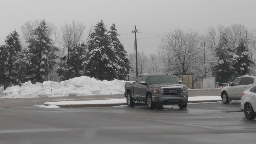
Some decent parking lot piles at work now after the last 2 waves..
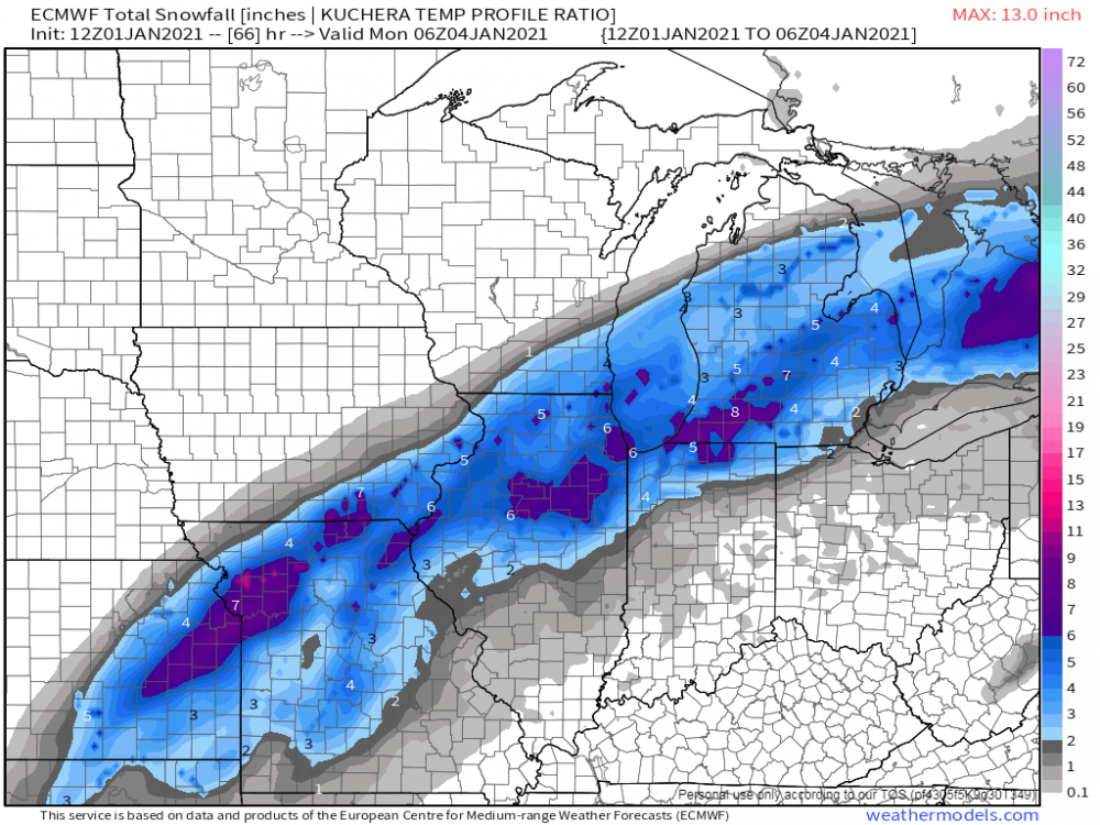
I got about a 2.5 inches total from new years day and system that rolled through last night. Pretty solid. I love the white wintry look on the trees!! Total for the season is about 7 inches or so. Main events was this one, the quick 2 incher on the night of the 29th, and the LES event on christmas eve/christmas which also brought around 2.5 inches. Small snows in the big scale of things but it doesn’t take much to make me happy. Still desire a big one or moderate one at the least! Hope we see it
-
4
-
-
33 minutes ago, Tom said:
12z Euro...looks a lot better for S MI peeps and into the SW burbs of IL...
Wow. Complete snoozefest on this 2nd wave on local forecasts stations here atm. Gotta think they rev up forecast totals soon
-
1
-
1
-
-
7 minutes ago, jaster220 said:
Not surprising, especially if it's not expected to hit GR proper. The southern row of counties would be better served by IWX to be honest the way GR ignores them. Last November for example, Jackson county got 8-14" in the Vet's Day storm and never got a Warning. Inexcusable imo
Loooool that’s ridiculous. Good tip on IWX, will keep that in mind.
-
1
-


January 2021 Observations and Discussion
in East of the Rockies
Posted
hahah it's all good man; still more snow I've seen in a season than I can remember. Is there a link to the data you have from those winters you've mentioned? And just based on how it's going so far, do you think this one will at least give us close to the snowfall totals from the winters the past 3 seasons? I feel like I'd be lucky to break 30 even 20 inches for the season right now seeing kalamazoo has really only had 7-9 inches so far.