


Jayhawker85
-
Posts
300 -
Joined
-
Last visited
Posts posted by Jayhawker85
-
-
40 minutes ago, Clinton said:
I'm going to easily break the record low of 28 tonight. This should kick the fall colors into overdrive.
Yay!! No more allergy medicine for me!!
-
 3
3
-
 1
1
-
-
10 hours ago, Clinton said:
Here is a link with the latest drought information for Missouri and Kansas. Drought conditions continue to spread into the eastern part of the country as well.
https://www.weather.gov/media/eax/drought/drought.pdf
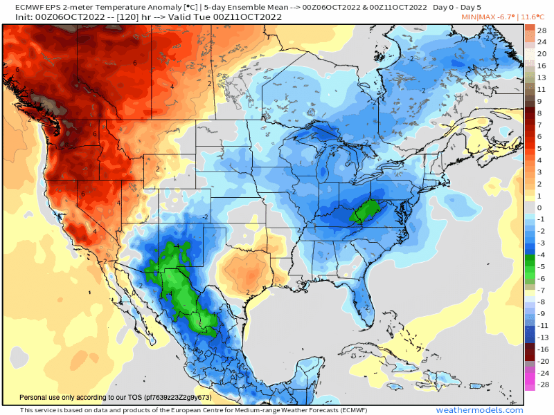
The 30 day QPF 30 day anomaly continues to look bleak on the Euro Weeklies, GEFS Extended, and CMC Extended. Sadly this could be the biggest topic this Winter.


And this is why i laughed at forecast calls about winter being so brutal and snowy. This first month of the new LRC is showing clear signs of a major drought happening in the heart of the plains where all our Ag comes from. Aka grocery prices will continue to climb next year from heat and drought
-
1
-
-
3 hours ago, Tom said:
This will be a long post and cover a broad spectrum of the developing OCT wx pattern. They say, "What happens in OCT, Cycles Back in DEC"...friends, what I'm seeing evolving this month is eye candy for literally all of us on this Sub. Even though I'm out here in the deserts of Arizona, where it is still Summer in my book, I'm getting tickled with excitement at the data I'm reviewing. The models tend to struggle Bigly during the change of seasons and none morse than now.
Today, on average, marks the 1st day of the new LRC pattern. We won't know when Day 1 is until later on this calendar year but I feel pretty confident that we are experiencing the 1st days of the new pattern. The cut-off trough in the SW is a big clue, the developing NE PAC/W NAMER ridge is another one, the Trough N/NW of Hawaii is HUGE, and then the lower heights that stretch all the way from Baja of Mexico into the southern GOM states add confidence that an active STJ will be part of the Long Term Long Wave pattern. Those that live over the southern 1/2 of the Sub must be rather intrigued with this developing pattern. I'll be honest, I've been watching this region closely bc we haven't seen something as such in a number of years.
Nearly all the models are all showing a similar jet stream pattern for the southern edge of the U.S...2 things that stand out....1) Split Flow over the West. 2) N Caribbean Ridge (not the GOM Ridge we have seen before)....if you fast forward this jet pattern in the winter months when it shifts south...look out...#ActiveSTJ...all day...SW Flow will combine with Tropical moisture.

Overnight runs of the models, confirm what I have opined that from the GL's/MW and points East the pattern looks trough-like and cool, while folks farther west/south experience your typical volatile temp pattern. The combination of both a -EPO/+PNA is a major clue that this will be a common player on the field as we head deeper into the cold season.
Let's take a look at the latest JMA weeklies as they pretty much sum up with what I was saying above...
Week 2...nasty looking W NAMER Ridge and lower heights over the southern US...
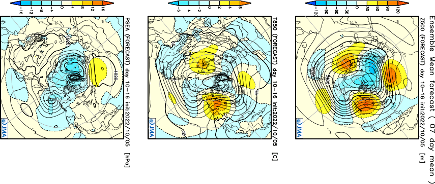
Temp/Precip...BN temps from the SW/Central/East U.S. and a wet SW/S Plains...
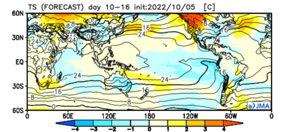
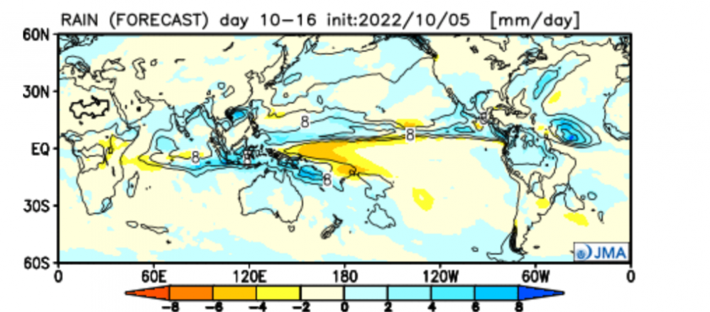
Week 3-4...Blocking up on Top and a beauty of a trough underneath...oh yeah, I almost missed this but check out the East Asian Trough...that is a good piece of info to produce a trough over the Eastern CONUS come NOV.
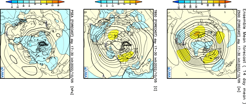
Temp/Precip...nearly an identical temp pattern and remember this is a LR forecast so it could very well end up being a lot colder provided the blocking ends up being right. The mean placement of the trough over the CONUS should produce a very active pattern 2nd half of OCT. Let's see who will be the winners and losers but I suspect there will be a lot of more winners this month.


So far this pattern looks dry for the central Midwest and points west. Pacific ridging and NW flow is never good for us and just being cold fronts and dryness. We shall see how this pattern evolves over the next couple weeks
-
6
-
-
1 hour ago, MIKEKC said:
Paging MOTHER NATURE! Did you forget about us????
Drought is intensifying here in KC. Trees are already turning color but its the dead color look....
Hopefully next weekend we see some widespread moisture in the Central Plains.
as much as i want moisture here i need it to hold off a couple days as i have a outdoor event next weekend! I need sun and warmth

-
1
-
-
14 minutes ago, Clinton said:
I bet the cooler air feels nice after yesterday's roasting. I hope some of those storms make it this way this afternoon.
It should feel a lot better today outside of the humidity. Hopefully the rain makes it over to you this afternoon!
-
1
-
-
Went from heat and drought conditions yesterday to a flood advisory this morning! About 1.5 inches have fell in the last hour and they are expecting more showers and storms throughout the day
-
2
-
 3
3
-
-
5 hours ago, Clinton said:
@Jayhawker85and @mlgamer models are lining up well for us to get a much need drink overnight and tomorrow. Good luck guys!
Radar is starting to light up along 70 so let’s see how this training turns out! Everything around here is really drying out!
-
2
-
-
1 hour ago, Clinton said:
In Gary's blog this morning he showed how it all came together with the cell developing ahead of the line of storms and then merging with the line. Sounds like it bounced up and down and uprooted some trees and alot of roof damage. I only got .40 and have gotten .7 inches for the week. Tomorrow night could produce a similar setup!
I drove by a couple minutes ago and there is a lot of tree damage, power lines down, and some structural damages to buildings.
i just spoke to a guy who runs a emergency response team and he said they have been getting calls nonstop since 130 this morning about damage to homes and businesses
-
3
-
 1
1
-
-
confirmed tornado last night in kc metro area. Landed about 5 minutes north of my job in Overland Park. I’m going to drive by it in a few to see how bad it is
-
5
-
 3
3
-
-
18 minutes ago, Clinton said:
Yes he did and as far as I know he is cancer free. I hope it hasn't came back.
Yes he will be missed. He said he’s been cancer free since 2000. I guess he is going to focus and take his LRC tool on a global scale which is why is he leaving the station.
Why not if it’s going to make him more money!
-
4
-
-
Gary or as everyone knows on here Mr. LRC has officially announced his retirement today. He will be missed on the television screen!
-
3
-
-
Received .65 last night from the loud boomers just before bed. Hopefully we can crank out a couple more inches before the heat settles in this weekend
-
2
-
-
1 hour ago, Clinton said:
Storms last night produced a lot of thunder and lightning but not much rain I picked up .55in, the heavier rainfall was just off to my south and west.
I’m shocked you didn’t get more rain last night as we did. It was pretty neat seeing the curling ball on radar move right over Topeka and Lawrence.
we got A LOT of heavy rain with the cells moving over us causing a flash flood warning for a couple hours. My weather app says only 1.5 inches but That’s wrong as we got that easily in the first hour.-
1
-
2
-
-
9 hours ago, Clinton said:
@Jayhawker85and other KC folks, looks like a big bowing storm just went through your area headed my way. 63mph winds reported in Olathe. Any reports?
We had some big boomers that woke me up with about .75 inches of rain. The clouds moved out around 1pm and been a beautiful afternoon
-
1
-
-
Woke up to early morning loud boomers here in Lawrence. Rain gauge says about 1.60 inches so far. We will see if we can get a round 2 later this evening
-
2
-
2
-
-
1 hour ago, Clinton said:
Steady rain has produced about a 1/2 inch of rain so far. Heavier rain expected overnight and tomorrow afternoon. Can't wait to the sun again.
Just wait till it hits 90 next week and the humidity will feel awful outside lol
-
 1
1
-
-
46 minutes ago, bud2380 said:
The Euro has highs well into the 80s and pushing 90 for much of next week with dew points surging into the low 70s! It's a miracle! And naturally we went from extended winter to summer, with no nice spring weather in between. But I'll gladly take heat and humidity over what we've had.


I don’t see this happening next week lol. Mid 70 dew points all the way up to Minnesota and Wi in early may is extremely rare. The Euro has it going from cold and snow to mid July in the matter of a few days lol
-
2
-
 4
4
-
-
2 hours ago, Clinton said:
Moderate risk area now issued and enhanced area also pushed further east right up to my door step.

I’m concerned with the amount of cloud cover and morning storms that won’t make this evening activity not so active. We will see if we are able to clear out by noon
-
2
-
-
2 minutes ago, Clinton said:
Winds are still gusty.
The house has been rattling all night long and all day. Hopefully we can break up these clouds to get some sunshine to get some good storms going
-
1
-
-
Big storms with heavy rain here in lawrence for the last 45 minutes. Have a storm made River in the backyard thanks to the storms training
-
3
-
1
-
-
2 hours ago, Clinton said:
GFS keep trending colder for the late week storm.

I told you we had 1 more storm for the season:)
-
3
-
1
-
-
1 hour ago, Clinton said:
Looks like I will finish with 26 inches for the season amazingly 25 inches fell in Feb-March 10th.
Glad to hear the storm did as expected as some was calling it a dud!
-
4
-
-
Looks like kc is getting some pretty good snows right now so they should catch up to us folks to the West.
we are still getting light snow here in lawrence and have added about .75 inches to our totals
-
2
-
 1
1
-
-
17 minutes ago, winterfreak said:
Heavy snow for the last half hour. Probably closer to 4 or 5…perhaps.
Guess it wasn’t a complete weather bust! Lol
-
1
-

11/14 - 11/20 | Possible Southern Plains to Great Lakes Accumulating Snow
in East of the Rockies
Posted
The snowflake contest may come to a end before the deadline is even up