


Bumblin Bman09
-
Posts
29 -
Joined
-
Last visited
Posts posted by Bumblin Bman09
-
-
Heading out to shovel/blow the snow now. Looks like 4-5" with large flakes and wind. Not a bad start.
-
 2
2
-
-
1 minute ago, metallica470 said:
I am at the same latitude as you, just 25 miles west. Still concerned about being too warm especially after how the last storm went.
I am up North in Gurnee and still worried with the warm temps North and off the Lake. I am not sure what to expect as this storm unfolds
-
2 minutes ago, Tom said:
12z GFS including the backside snow and LES...>>>Buried

I havent heard much in terms of LES. Will it be a quick burst due to the storm quickly moving East?
-
This Rain/Snow line is getting too far north. Id prefer to have all SNOW. I don't like the mix
-
-
I like LOT WSW for NIL (near WISC border). Based on current runs the 6+ seems accurate. I don't think we exceed a foo but I think we end up in the 6-12 range. LE as the storm moves east could help totals.
-
1
-
-
12 minutes ago, Tom said:
I would move her flight 100%...Thursday pm is the "Calm before the Storm"...
Thanks @Tom . I was leaning that way but was looking for reassurance. On with airline now. Thanks again
-
2
-
-
@Tom I mentioned earlier my wife is flying out of ORD at 6pm Friday evening. I am considering moving her flight to Thursday evening. What are your thoughts on this storm with where we stand now.
-
23 minutes ago, Jaycee_CHI said:
Saaaame. 5 miles west it’s snowing, but rain here! I’m so sad
 hopefully it changes over again but I’m not holding my breath!
Same up in the Gurnee, IL area. Hoping the Friday/Saturday storm brings more whiteness.
-
Basically nothing up in Gurnee, IL. Rain mixed in, roads are clear, and nothing on the ground. I see additional mixing and rain later today.
-
4 hours ago, Tom said:
This one has my interest as my father, brother and his family are going to Holland, MI for a tournament this weekend. If the models continue to trend towards a Blizzard, I doubt they go and it gets cancelled. TBH, I'm a bit jelly if this storm ends ups going nuclear. Tracking this storm from afar, I've never seen the models show such a deep low and vicious cold/wind for the lower lakes. @Hoosier, your right about this powerhouse which could be a legendary JAN storm...like back in the late 70's!
My wife is headed to Philly on Friday for a Hockey tournament and my buddy is headed to Holland for a hockey tournament this coming weekend. I already informed them to try and book travel earlier if possible.
-
15 minutes ago, Jayhawker85 said:
Let’s just go ahead and lock this in and call it a day! Lol
I am up in Northern IL and would lock this in now as well. I am more excited with the cold coming in with several other chacnes for higher ratio events.
-
7
-
-
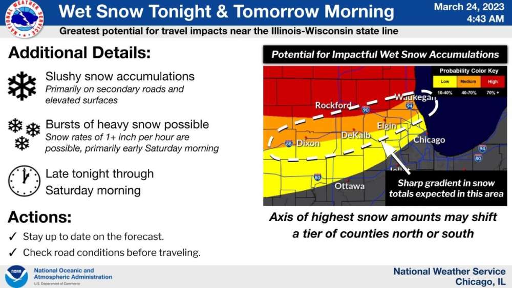
Updated graphic with a WWA suggesting 4-7” for Lake County
-
3
-
-
@Tom Much appreciated Tom. Looks like I may have an issue getting a flight Thursday PM due to meeting schedule, however, I should be able to get on an early flight Friday AM. I think its crazy the N IL could get a decent size snowfall or 1".
-
1
-
-
@Tom I am currently due to return back to ORD on Friday at 2pm. I haven't adjusted my flight yet, however, I am considering moving my flight to Thursday PM or Friday AM. You have any thoughts on my current status? Thanks for any feedback.
-
Was snowing at a good clip in the Gurnee area. No significant accumulation yet, however, roads and grass surfaces are covered. Looks like a couple intense bands are to our southwest. Hopefully they arrive shortly
-
2
-
-
Lake county upgraded to WSW .
Winter Storm Warning
URGENT - WINTER WEATHER MESSAGE
National Weather Service Chicago IL
213 PM CST Wed Feb 15 2023

ILZ006-160415-
/O.UPG.KLOT.WS.A.0001.230216T0900Z-230217T0300Z/
/O.NEW.KLOT.WS.W.0002.230216T1200Z-230217T0300Z/
Lake IL-
Including the cities of Waukegan, Buffalo Grove, Mundelein,
and Gurnee
213 PM CST Wed Feb 15 2023

...WINTER STORM WARNING IN EFFECT FROM 6 AM TO 9 PM CST
THURSDAY...

* WHAT...Heavy mixed precipitation expected. Total snow
  accumulations of 4 to 7 inches and ice accumulations of a
  light glaze. Winds gusting as high as 40 mph.

* WHERE...Lake IL County.

* WHEN...From 6 AM to 9 PM CST Thursday.

* IMPACTS...Plan on slippery road conditions. The hazardous
  conditions likely impact the morning and afternoon commute.

PRECAUTIONARY/PREPAREDNESS ACTIONS...

If you must travel, keep an extra flashlight, food, and water in
your vehicle in case of an emergency.

The latest road conditions for Illinois can be obtained on the
internet at www.gettingaroundillinois.com.

&&
-
3
-
 1
1
-
-
https://nwschat.weather.gov/p.php?pid=202301280940-KLOT-WWUS43-WSWLOT
nws Chicago sticking with the 2-6”. Looking closer to 4-6” in the Northern Lake county. I hope it pans out.
-
4 minutes ago, Tony said:
What a kick in the gut the last couple days of model watching this has been. From a monster storm to almost nothing for at least us west of MI/IN. This was hyped so much that LOT had to issue a WSW for a couple inches of snow. I know there will be blowing snow but no big deal as the deeper winds will be farther east. We are all still hoping for a faster deepening of the storm, for those of us farther west, but I highly doubt this is going to happen.
Yup. Not in the cards for us this time around. I was hoping for a big one. Ugh
-
 1
1
-
-
3 minutes ago, Hoosier said:
Full circle also sort of depends what is being talked about. Remember those crazy west/extremely snowy GFS runs. That's not going to happen at this point, but smaller changes to something more impressive are definitely possible.
Im not buying the upped totals off of that run. I would love 6-10" near the WI border but I think we're closing to 3-6". Time will tell.
-
12 minutes ago, jaster220 said:
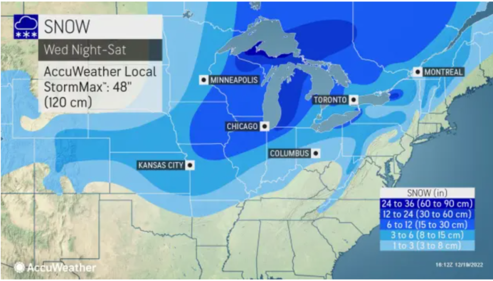
Mappage. Big Storm
Seems a tad bit off. Especially around chicago and Wisconsin lol
-
 1
1
-
-
Up in Gurnee near the Wisconsin state line. Not looking good in terms of amounts. Should’ve known the models would pull back significantly in the 2-3 days leading up to the event. Ugh. I’m hoping for 6” at this point
-
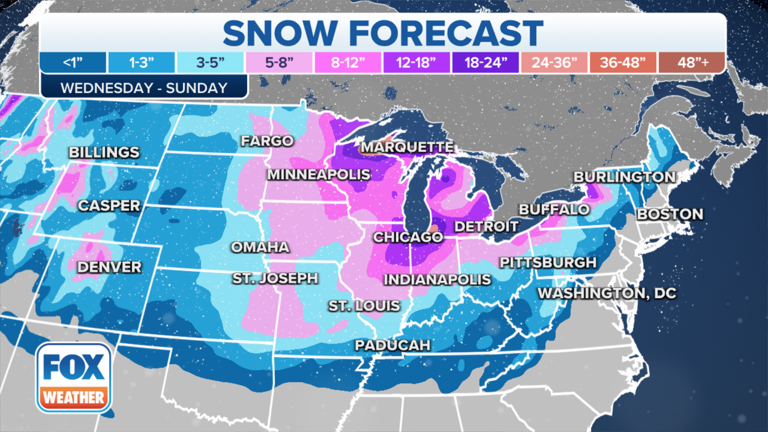
This is the first map I've seen showing amounts
-
6
-
-
I dont post much but find all of your analysis' of the system great. I am sitting in N IL near the Wisconsin border and cautiously optimistic of a decent amount of snow. We haven't had a solid base for Christmas in quite some time.
I am also travelling from Eastern Indiana back to Chicago area on Thursday AM. I hope it holds off until Thurs PM
-
1
-


January 11-13 Major Winter Storm/Blizzard
in East of the Rockies
Posted
We only got about 3" up in NE IL. I was expecting more and hopefully we get another