Snownerd3000
-
Posts
2317 -
Joined
-
Last visited
Everything posted by Snownerd3000
-
PNW November 2021 Wx Obs/Discussion
Snownerd3000 replied to Meatyorologist's topic in West of the Rockies
Oh I saw lol. What's got me excited is the timing. Jives with those weeklies -
PNW November 2021 Wx Obs/Discussion
Snownerd3000 replied to Meatyorologist's topic in West of the Rockies
What is this sorcery!? -
PNW November 2021 Wx Obs/Discussion
Snownerd3000 replied to Meatyorologist's topic in West of the Rockies
Also worth noting, the 0z also had the Arctic air mass knocking at our door in the clown range. I'm going to be super impressed with the long range skill of both models if this mid month timing comes through. -
PNW November 2021 Wx Obs/Discussion
Snownerd3000 replied to Meatyorologist's topic in West of the Rockies
Tis weird.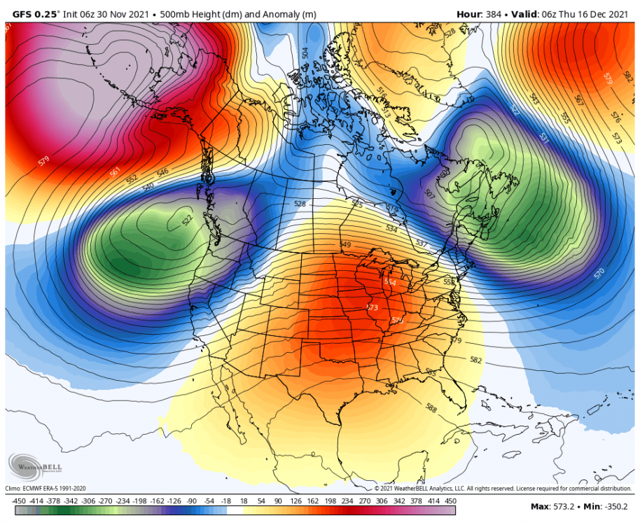
-
PNW November 2021 Wx Obs/Discussion
Snownerd3000 replied to Meatyorologist's topic in West of the Rockies
Pretty sure I've read Judah Cohen talk about Ural blocking dislodging the PV. That looks like it's in the right area. Would jive with the forecast SSW mod month -
PNW November 2021 Wx Obs/Discussion
Snownerd3000 replied to Meatyorologist's topic in West of the Rockies
-
PNW November 2021 Wx Obs/Discussion
Snownerd3000 replied to Meatyorologist's topic in West of the Rockies
Think that was 96, right after Christmas. That was a fun event. The start of that snow the day after Christmas was one of the most insane snows I've ever seen. I was at my buddies playing the N64 they got for Christmas. When the flakes came, they fell hard and fast. They look fat and fluffy but we ran out in it to celebrate and were bombarded by the flakes, they kinda stung when they hit your skin. Never seen snow like that since. -
PNW November 2021 Wx Obs/Discussion
Snownerd3000 replied to Meatyorologist's topic in West of the Rockies
Anyone well versed in reading a 10mb map? I have zero clue on this when I see Judah Cohen or anyone else for that matter share pics of them. -
PNW November 2021 Wx Obs/Discussion
Snownerd3000 replied to Meatyorologist's topic in West of the Rockies
-
PNW November 2021 Wx Obs/Discussion
Snownerd3000 replied to Meatyorologist's topic in West of the Rockies
I'm new but have been calling this since my first post on the 18th. -
PNW November 2021 Wx Obs/Discussion
Snownerd3000 replied to Meatyorologist's topic in West of the Rockies
This is the weirdest setup. Really need that H to retro a touch to really get this juicy -
PNW November 2021 Wx Obs/Discussion
Snownerd3000 replied to Meatyorologist's topic in West of the Rockies
Here is the Gefs ext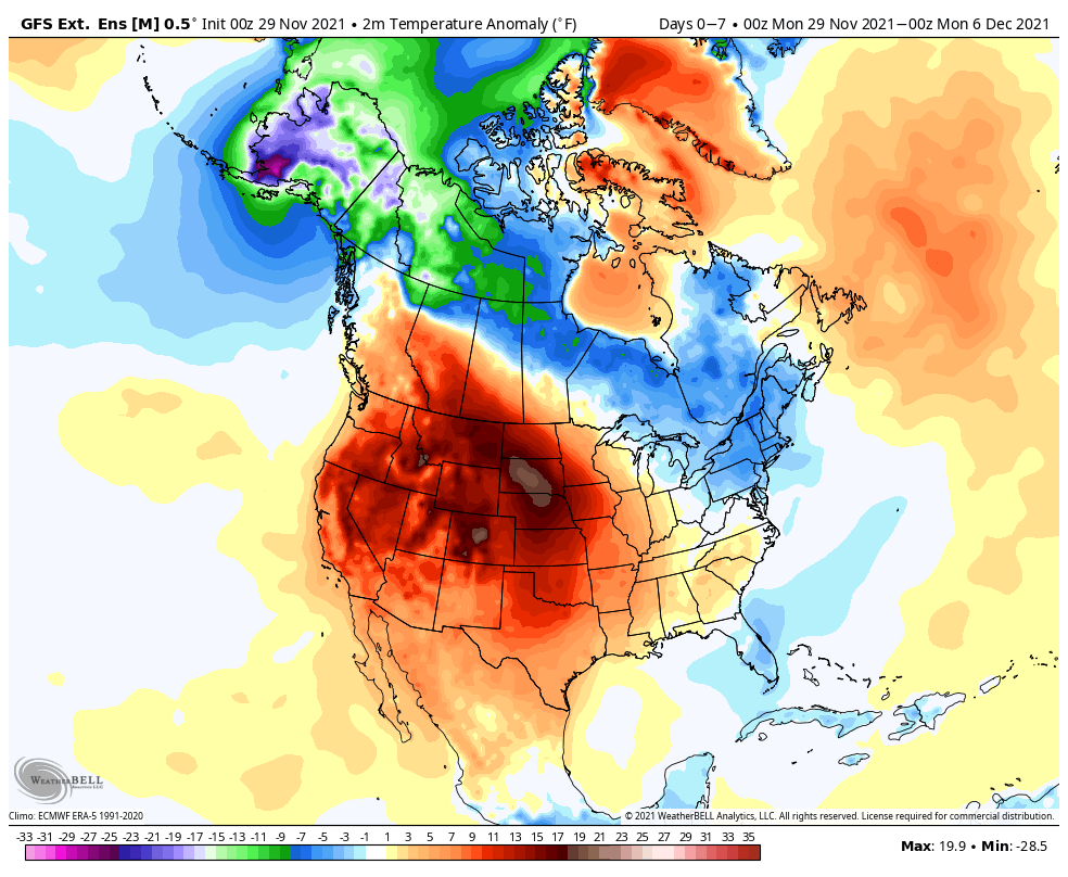
-
PNW November 2021 Wx Obs/Discussion
Snownerd3000 replied to Meatyorologist's topic in West of the Rockies
The gfs ext is still running but so far very close to timing and scope. Will post after I get my shitlins down. -
PNW November 2021 Wx Obs/Discussion
Snownerd3000 replied to Meatyorologist's topic in West of the Rockies
If only it could land in CA instead -
PNW November 2021 Wx Obs/Discussion
Snownerd3000 replied to Meatyorologist's topic in West of the Rockies
Do what we can! -
PNW November 2021 Wx Obs/Discussion
Snownerd3000 replied to Meatyorologist's topic in West of the Rockies
Don't upset Biggie -
PNW November 2021 Wx Obs/Discussion
Snownerd3000 replied to Meatyorologist's topic in West of the Rockies
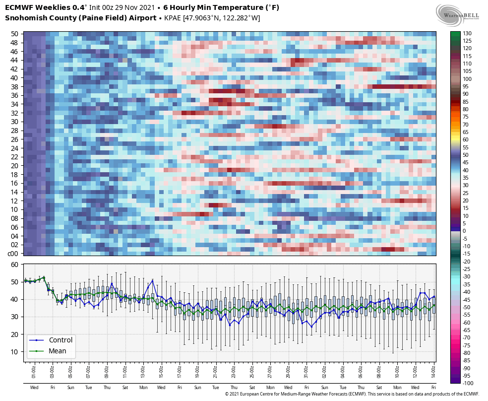
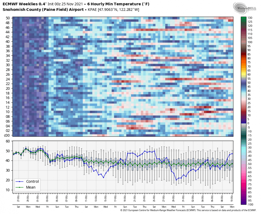
Here are the last 3 Weeklies. Seems to me there is growing consensus among the members for when this cold air might get in the puget sound region.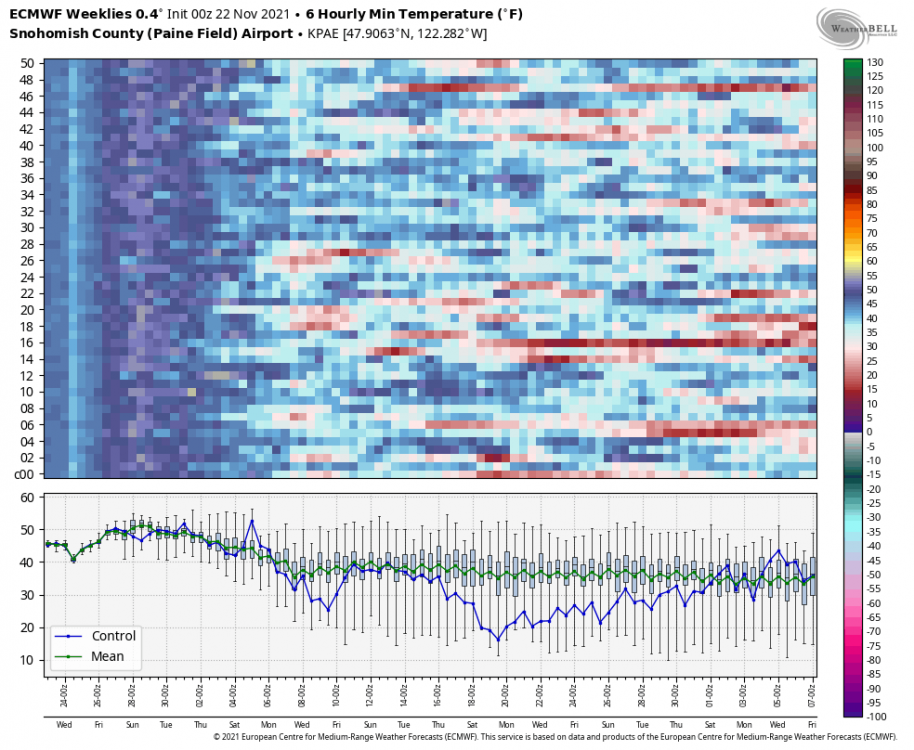

-
PNW November 2021 Wx Obs/Discussion
Snownerd3000 replied to Meatyorologist's topic in West of the Rockies
-
PNW November 2021 Wx Obs/Discussion
Snownerd3000 replied to Meatyorologist's topic in West of the Rockies
Hoping the consistency in the model output is a good sign. Been pretty consistent with that cold coming mid month -
PNW November 2021 Wx Obs/Discussion
Snownerd3000 replied to Meatyorologist's topic in West of the Rockies
The control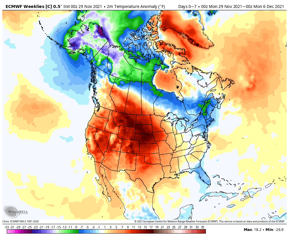
-
PNW November 2021 Wx Obs/Discussion
Snownerd3000 replied to Meatyorologist's topic in West of the Rockies
Weeklies temp anomaly map really likes that mid month shot.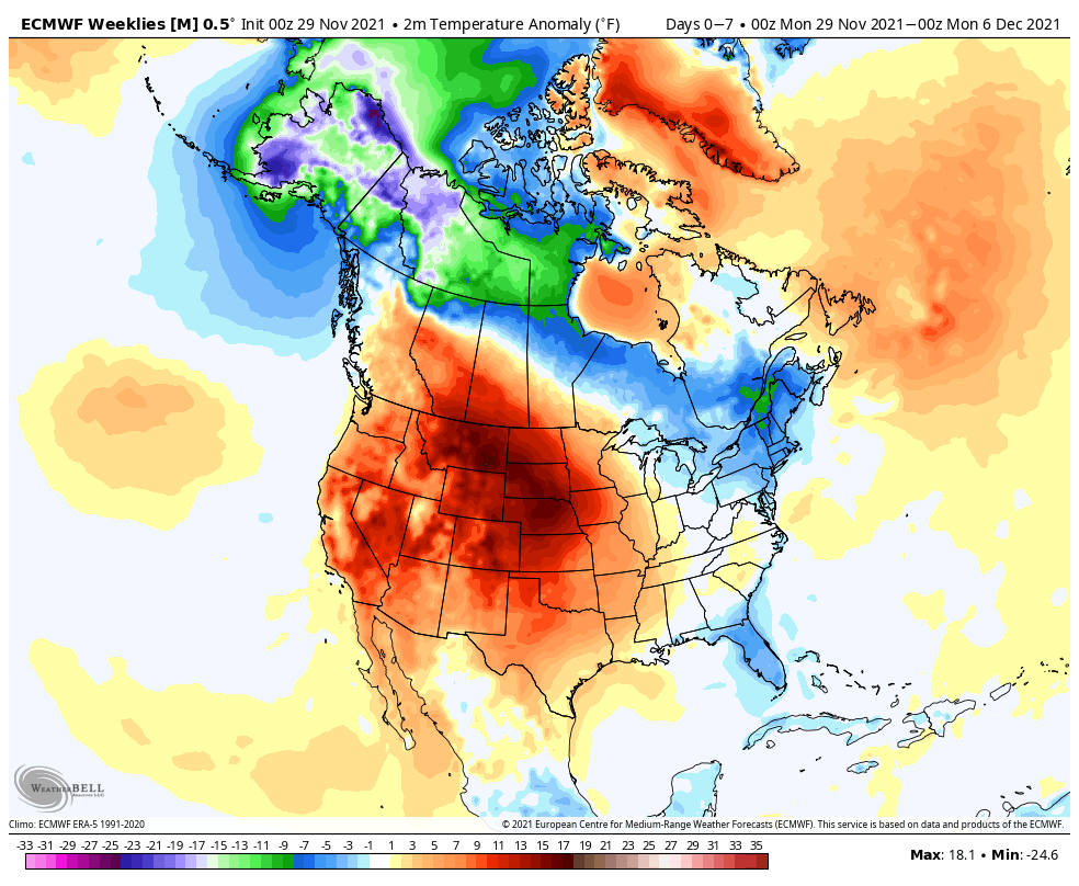
-
PNW November 2021 Wx Obs/Discussion
Snownerd3000 replied to Meatyorologist's topic in West of the Rockies
Until the EURO hits you with that extra strength turbo lax -
PNW November 2021 Wx Obs/Discussion
Snownerd3000 replied to Meatyorologist's topic in West of the Rockies
Only thing I don't like about the sun this time of year is the low angles really **** with you when driving. -
PNW November 2021 Wx Obs/Discussion
Snownerd3000 replied to Meatyorologist's topic in West of the Rockies
I mean, you're wrong until 1 today as I seem to have misplaced my DeLorean to get things from the future to make it the most recent. I'll follow up when the future become present and offer up the most recent images ;). -
PNW November 2021 Wx Obs/Discussion
Snownerd3000 replied to Meatyorologist's topic in West of the Rockies
Dear lort, just caught the 12z GFS. Here's hoping that mass of cold air towards the clown range verifies. Nothing better than very cold air locked up in interior BC to get reinforcing shots of cold for the PNW. Funny, the timing looks to jive with what a number of the Weekly and GFS ext forecasts have shown. Here is the most recent Weekly control for the week starting the 15th. and the ensemble mean.