

FV-Mike
-
Posts
633 -
Joined
-
Last visited
Posts posted by FV-Mike
-
-
49 minutes ago, snowstorm83 said:
It's a balmy 68 in Lincoln, while 8 hours to the east in Chicago it's 33 with light snow. Even between Omaha and Lincoln there's quite the contrast (68 vs 56).

The map is crazy. Currently I am sitting at 32 degrees overcast and light winds. The day has had a winter feel to it.
-
 2
2
-
-
Just a wild day of weather. Glad most of the forum got in on this.
Currently have heavy ran, lightning, gusts to 30mph and 47 degrees
-
5
-
-
8 minutes ago, Tom said:
What a treat this morning...it’s like a balancing act by nature to those who missed the previous LES event...
Great video!
-
1
-
-
- Popular Post
- Popular Post
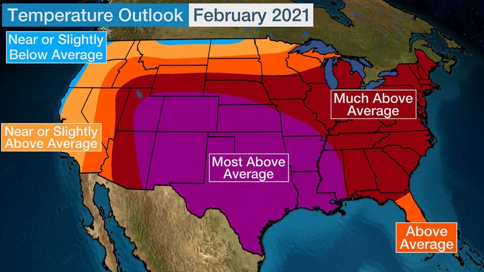
Just a reminder of The Weather Channels FEB temp forecast
-
1
-
 14
14
-
 1
1
-
 1
1
-
29 minutes ago, Tom said:
I think we just tied the old record for 9 consecutive days with measurable snow. An extraordinary stretch of winter weather. Unlike the previous record streak in Feb ‘18, this one will surpass it in many ways. The amount of powdery snows on top of snow is a visual I’ll never forget. On the drive to the gym this morning, the piles and drifts look like the snow belts up north. Just amazing to see. A lot of people (including Tom Skilling) in Chicago have been referencing the late 70’s as being a comparable stretch. How much do you have OTG?
Yep, I am amazed at the piles. I live on a cul-de-sac and our town had the front loader out this morning pushing the snow and loading into dump trucks. its been since 13-14 since the last time saw that!
-
2
-
-
Crazy note from LOT on Chicago area's Feb so far.
A remarkable stretch, with Chicago having seen measurable snow on 12 of the 16 days of February including today and going back to January 25th, 16 of the past 23 days with measurable snow-
2
-
 1
1
-
-
With the blowing it was hard to measure. I think I am around 5 inches. O'Hare at 7.5. Saw Evanston at 17
-
4
-
-
O'hare point forecast updated to 6-10 inches
-
4
-
-
Winter storm warnings issued for Cook and points south. WWA for points west. opening line of LOT's AFD
Boy, what a shift in forecast model guidance compared to 24 hours ago! Based on a discussion with the Weather Prediction Center (WPC), the changes have to do with a trend toward a stronger system overall, and hence better moisture transport to its backside and in our neck of the woods.-
2
-
 1
1
-
-
One more decent band moving through. Been a great day of light snow falling
-
2
-
-
Big Fatties flying. band is setting up between I-90 and I-88
-
 2
2
-
-
2.4 official at O'hare. 2.9 at midway. Multiple reports of 50+ wind gusts.
-
3
-
 1
1
-
-
This tidbit from LOT should bring back good memories for the GL folks
This general pattern featuring negative height anomalies over the north central US will essentially lock in due to the blocking to the north while positive height anomalies develop from the southern US to at least up into the Mid Atlantic. The general pattern described above has historically been characterized by snowy and very cold conditions across the Midwest, and is a decent analog for January-February 2014 (aside from the extreme NAO blocking which that winter did not have). This is due to our area being positioned right on the nose of a strong polar jet and multiple Pacific hybrid type waves coming ashore in the northeast Pacific and tracking southeast then east.-
5
-
-
Ripping here now. Huge flakes. Chi town about to get pounded
-
1
-
-
All Snow now. Working in Dekalb county.
-
1
-
-
ORD at 6.8 as of 6 am.
Romeoville (official nws site) at 9.5

-
1
-
-
Man the models have been so consistent over the last couple of days for N IL/SE Wi and In to get a good thumping. Really interesting to see
-
1
-
-
Roselle up to 7 inches. ORD just crossed 6 inches
-
2
-
-
Starting to rip here.
-
 1
1
-
-
2 minutes ago, snowstorm83 said:
Intense band coming through Lincoln, ripping hard and flake size is even decent, visibility probably around 1/5 of a mile. I remember NAM last night only having around 3" by noon but I wouldn't be surprised to have 6" by then.
You may have mentioned it before but do you know when the last double digit snowfall for Lincoln was? Best of Luck
-
1
-
-
LOT Update at 9:50am
There are no major updates being made to the forecast this morning. Targets of opportunity for the afternoon forecast package will be refining snow totals: (1) Between I-39 and I-355 where a local minima may materialize between the heavier snow rates to our west and lake enhancement, respectively (2) Along the IL/WI border where persistent lift through the DGZ may lead to fluffier snow ratios (3) Along I-80 where a tight snow gradient is anticipated due to the dry slot "squeezing" the DGZ northward, and (4) After daybreak Tuesday as snow ratios increase and the upper- level wave finally pulls through. At this point the highest snow totals are expected across lakeshore communities and especially Cook county where 4 to 8, locally more, are probable. The steadiest snow rates, approaching 1"/hr, are expected from roughly 6 PM to midnight, with rates gradually decreasing toward daybreak Tuesday. Snow rates may remain heavy along the Lake Michigan shore through daybreak Tuesday due to lake enhancement-
1
-
1
-
-
3 minutes ago, jcwxguy said:
.thumb.png.082e368e225c8d216dd01ab0bbb511e7.png)
.thumb.png.53faae9e5c8de153a72e9a15393a8ad9.png)
Any chance you could share further east. Thanks
-
1
-
-
7 minutes ago, shakjen said:
But yet they just upgraded northern Illinois to a winter storm warning. Must be looking at different models.
5-8 inches with gusty winds. I’ll take it
-
2
-
1
-
-
24 minutes ago, bud2380 said:
Latest graphic from DMX
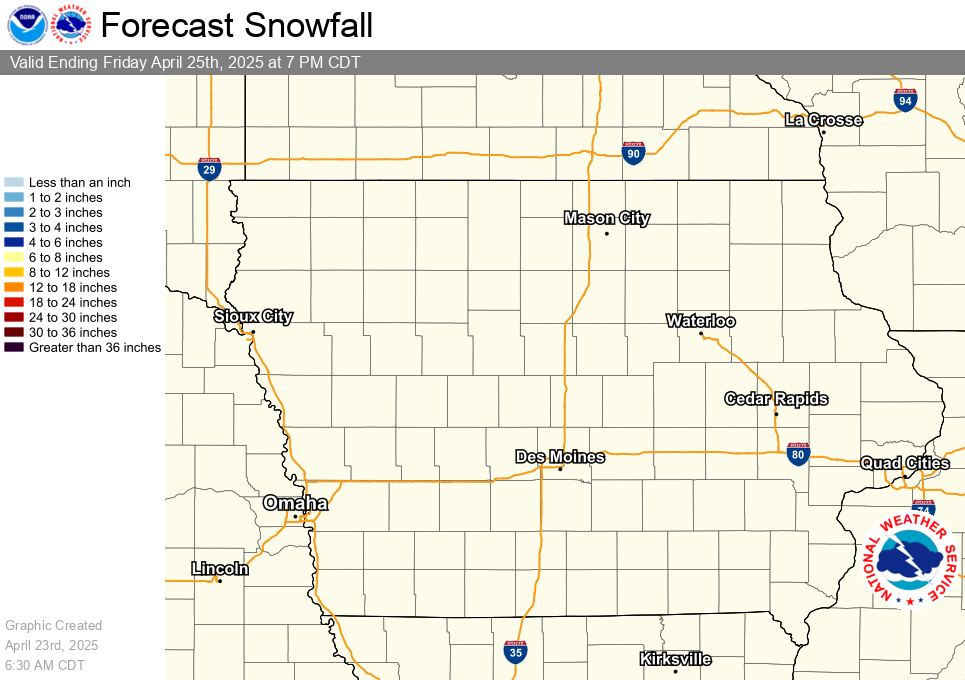
This seems reasonable
.png.f690ae21fea8e0b383114170a6774d1f.png)
.png.d812e8ae76d03452158bf1c3f67c195a.png)
December 2021 Observations and Discussion
in East of the Rockies
Posted
I am not greedy. Give me 1-3 inches to start off the season and I am happy