


luterra
-
Posts
223 -
Joined
-
Last visited
Posts posted by luterra
-
-
3 minutes ago, SimplySmoothWX said:
21 F and all snow here in Beaver country.
Since there are no hills nearby some kids are trying to sled by holding on to a rope attached the back of a pickup truck. Average college student shenanigans

Have not seen any actual snow in my (SW) part of town. Light ZR glaze then around an inch of sleet. Switched back to ZR while I was out walking over the last couple of hours and now have sleet mixing back in. About 0.2" of ice accumulation, I'm feeling like we dodged a bullet with this one. Temp steady at 23-24.
-
 3
3
-
-
30 minutes ago, SilverFallsAndrew said:
We hit 17 with 10” depth. We were 5 deg colder yesterday.
If you don’t hear from me this week, please send a plow.
You must have been protected from the NE winds yesterday. We were stable at 24 all night with consistent mixing and some serious wind chill.
-
13 minutes ago, TT-SEA said:
The power of snow cover!
17 in Corvallis with no snow cover. I thought snowy areas might be colder.
-
3
-
-
1 hour ago, snow_wizard said:
I'm noticing a huge lack of posters from OR. I hope it didn't get TOO bad down there.
My location got seriously blasted at 4 am - strongest winds in several years for sure - but the HWW period of 10 am-4pm was only mildly breezy. Almost calm now.
-
2
-
-
2 minutes ago, luterra said:
All of the damage and power outages in Corvallis happened in a very short period at 4 am. Winds are now much lighter by comparison. SSE winds can surface here much more easily than SW.
Peak gust at my sheltered station of 33 mph is the highest so far in this location (since 2016).
Peak winds corresponded with a brief but rapid pressure rise from the lowest point (29.03") and a sudden temperature drop albeit only slightly more than a degree. Not much rain happening at the time.
What sort of phenomenon would this be? Passage of occluded front mixing winds briefly to the surface?
It also appears that the strongest winds were WSW amidst southerly gusts on either side.
-
1
-
-
All of the damage and power outages in Corvallis happened in a very short period at 4 am. Winds are now much lighter by comparison. SSE winds can surface here much more easily than SW.
Peak gust at my sheltered station of 33 mph is the highest so far in this location (since 2016).
Peak winds corresponded with a brief but rapid pressure rise from the lowest point (29.03") and a sudden temperature drop albeit only slightly more than a degree. Not much rain happening at the time.
What sort of phenomenon would this be? Passage of occluded front mixing winds briefly to the surface?
-
3
-
-
Kind of fun watching the ice plug break out of my rain gauge just now. With some likely undercounting due to the rate of bucket tipping, it shows 0.56" (since the start of ZR) and an instantaneous rain rate of 25" per hour.
-
1
-
-
Temperature finally going vertical here, a day later than predicted. From 32.5 when I woke up to 46 now, soon to be 50+.
-
2
-
-
34 minutes ago, icyasf said:
It has been holding for me at around 31.5. My bet is we’re gonna stay under 32 until around 12, and then start warming up.
Just hit 32.0. You might make it if you're 0.3 colder.
-
1 minute ago, icyasf said:
If we manage to stay under 32 for the next hour we would pull another subfreezing day in Corvallis.
Holding at 31.7/31.8 on my gauge since 9 pm. Warmup expected to commence around 1 am per the HRRR. Will be close, any bets?
-
1
-
-
46 minutes ago, SilverFallsAndrew said:
46/22 day here.
Still pretty chilly down in the South Valley with EUG only sitting at 34. Surprisingly Corvallis still hasn't cracked freezing and is at 30.
A little bit of warm-tongue/cold-tongue going on in the valley with the east side running 1-2 degrees warmer.
Definitely expected to be above freezing by now, although with the main roads mostly clear and no major precip incoming I guess it's OK...
-
1
-
-
33 minutes ago, Requiem said:
Offshore winds were extremely impressive from this event. Perhaps not at PDX's official station as much, but Corbett likely scored its strongest winds since just before the big February 1996 floods. The PDX-DLS gradient topped out at just over a massive 15 mb, which is really only below Christmas Eve 1983.
Impressive but extremely shallow, at least down south. I hardly had anything I would call a breeze here, 10-15 mph max.
-
2
-
-
30.6 with no significant precipitation since morning. Main roads are getting clear, side streets still a sheet of ice.
-
2
-
-
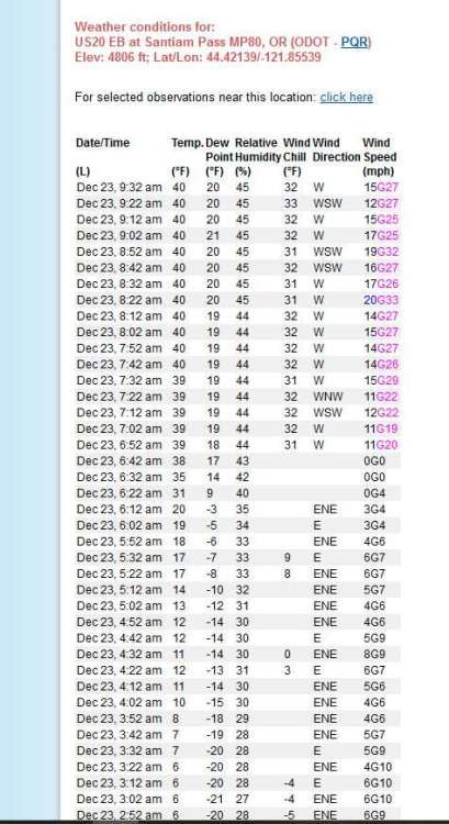
Impressive mix-out for Santiam Pass (4800') this morning. Started at 2F at midnight.
-
4
-
 1
1
-
 1
1
-
-
1 minute ago, luterra said:
I would estimate 0.35" on horizontal surfaces on the southwest side of town. Was fun to dig out the studded shoe grippers I got for the Grand Canyon a few years back and go for a walk around the neighborhood.
Trees all look surprisingly OK. Something about the way this fell, or maybe the small size of the drizzly drops, made it only accumulate on the top of twigs rather than encasing them in a circle of ice. They seem to collect a lot less weight that way.
27.3 and temp rising slowly and linearly. Extrapolation of the line puts us above freezing at 6 pm. Though I'm expecting to get a sudden warmup at some point.
-
5
-
-
12 minutes ago, icyasf said:
26 degrees right now with approximately 0.3 inches of ice. Roads are extremely bad right now. I didn’t want to actually go anywhere with ice on the ground so I was only able to take a picture from our porch.
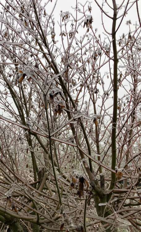
I would estimate 0.35" on horizontal surfaces on the southwest side of town. Was fun to dig out the studded shoe grippers I got for the Grand Canyon a few years back and go for a walk around the neighborhood.
Trees all look surprisingly OK. Something about the way this fell, or maybe the small size of the drizzly drops, made it only accumulate on the top of twigs rather than encasing them in a circle of ice. They seem to collect a lot less weight that way.
-
5
-
-
13 minutes ago, SilverFallsAndrew said:
I see EUG reporting light freezing rain now. Corvallis still reporting light snow, but I suspect it’s probably ZR, or maybe sleet.
My wife is on her way to Eugene. I suggested she leave early, but she didn’t listen to me.
Can confirm ZR sprinkles in Corvallis with a little sleet mixing in.
-
2
-
1
-
-
25 minutes ago, The Blob said:
It's coming

None of that is actually reaching the ground. No precip so far in Corvallis.
-
3
-
-
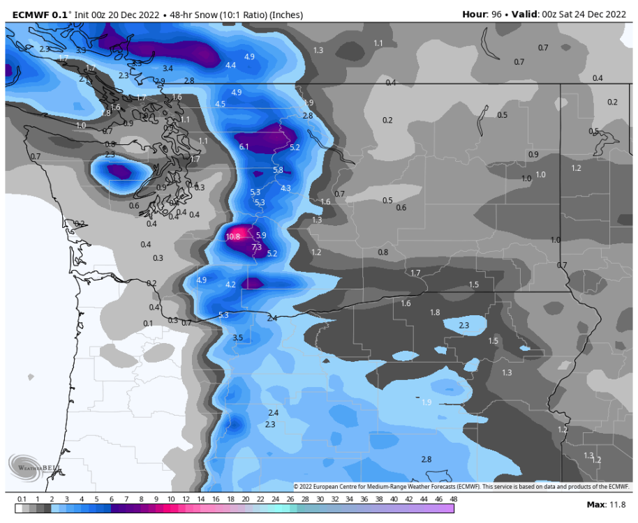
Just now, TT-SEA said:
Portland might a real freezing rain problem on Friday.
.thumb.png.c7ecd1857dec72acc58c851198b5fed6.png)
The whole region might have a freezing rain problem...
Thankfully not the sort of stationary overrunning that brought 1-2" of ice to places in Feb. 2021. Thanks for posting!
-
2
-
-
1 minute ago, TT-SEA said:
How about an ice map :-(.
-
Low of 21.8 at my place in Corvallis this morning before the fog finally formed. This location is good at getting cold in weak offshore flow/inversion situations: just enough outflow influence to generate dewpoint depressions and prevent the fog/stratus that Eugene sees more often, but with light enough winds to allow for effective decoupling and radiative cooling.
-
8
-
-
2 minutes ago, luterra said:
12Z GFS is the first run that seems realistic based on past cold events. Cold rain followed by snow showers in onshore flow and then brisk NE winds ushering in arctic air. One or two nights in the single digits (especially if snow cover) followed by an overrunning ice-to-rain transition on Christmas Eve. Would be the first event like this since Dec. 2013 for the south valley.
Why does no one ever mention Dec. 1972 when talking about historical analogs? With three consecutive subzero lows, down to -6 at the OSU station, that would seem to be the event of record when it comes to cold.
Also eight consecutive record lows in 1972 at the OSU station, though one of them got beat in 2013.
-
1
-
-
12Z GFS is the first run that seems realistic based on past cold events. Cold rain followed by snow showers in onshore flow and then brisk NE winds ushering in arctic air. One or two nights in the single digits (especially if snow cover) followed by an overrunning ice-to-rain transition on Christmas Eve. Would be the first event like this since Dec. 2013 for the south valley.
Why does no one ever mention Dec. 1972 when talking about historical analogs? With three consecutive subzero lows, down to -6 at the OSU station, that would seem to be the event of record when it comes to cold.
-
4
-
-
35 minutes ago, SilverFallsAndrew said:
Looks like it stays wet for the next 1-2 hours across the mid-valley.
Extreme model bust on precip amounts for today. Making up for Friday's underperforming AR.
1.10", still dumping at 37.2F
-
4
-


.png.e33438a4d1300c27d19bc7d3ddd30541.png)

January 2024 Weather in the PNW (Part II)
in West of the Rockies
Posted
Maybe but looking at radar and hi-res models it appears that the main precip focus is moving north of us and also the upper levels are cooling from here on out so I'm thinking we've passed our peak icing potential.
Even if all of the remaining ~0.4" of QPF were to fall as ZR we would be mostly OK, but that seems unlikely with the current transition back to sleet moving past peak heating. I feel confident in saying the 1" of ice scenario is not happening here.