

Minny_Weather
-
Posts
10525 -
Joined
-
Last visited
-
Days Won
19
Everything posted by Minny_Weather
-

3/24-3/27 Midwest/Plains Colorado Low(s)
Minny_Weather replied to Minny_Weather's topic in East of the Rockies
That's... Actually terrible for me. I'd like to not have to settle for 8" in late March. -
3/24-3/27 Midwest/Plains Colorado Low(s)
Minny_Weather replied to Minny_Weather's topic in East of the Rockies
I'm driving home from a hockey game in Fargo right now, and the snow has started way earlier than expected. I'm currently just passed Fergus Falls and it's actually pretty moderate. 24°F. -
3/24-3/27 Midwest/Plains Colorado Low(s)
Minny_Weather replied to Minny_Weather's topic in East of the Rockies
It seems like that's the position I've been in for nearly every storm since 2016, and most of the time it didn't end up working out. Whether it be on the wrong side of a sharp cutoff or on the rainy side of a rain/snow line. I'm selfishly glad that I've been sitting pretty for most of the model runs on this storm. -
3/24-3/27 Midwest/Plains Colorado Low(s)
Minny_Weather replied to Minny_Weather's topic in East of the Rockies
NAM is getting even more juiced, I end up with 16" at the end. -
3/24-3/27 Midwest/Plains Colorado Low(s)
Minny_Weather replied to Minny_Weather's topic in East of the Rockies
Liking the look of the SREF plume. It's lacking the couple of wacky ceiling outliers that we usually see from this, but the mean for here is still 14.5".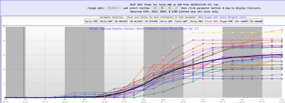
-
I'd call it more of an appetizer than a base. I expect much of this to be gone by the end of the day.
-
My eyeball guess is about 3". About what I expected from this, so can't say I'm disappointed. At least it looks like winter, which I wasn't able to say much during actual winter. I expect a lot of it to be gone after today with highs near the freezing mark and partial sun. 21°F.
-
Radar returns were definitely better than modeled for the first couple of hours of the storm. I think they downplayed the width of the heavy band and that translated into 1"/hr rates. Now, returns are about in line with what was modeled. Still, can't help but feel like we scored a bonus inch out of this. 3-4" may have just become 4-5". 23°F.
-
3/24-3/27 Midwest/Plains Colorado Low(s)
Minny_Weather replied to Minny_Weather's topic in East of the Rockies
Guessing the lower max totals are going to continue as well as a result of better sampling. Edit: I'm stupid and didn't realize this run ends in the middle of the storm. -
Fat flakes have been coming down for the last 30 or so minutes
-
3/24-3/27 Midwest/Plains Colorado Low(s)
Minny_Weather replied to Minny_Weather's topic in East of the Rockies
A slight shift North would be nice. I'm not sure I want to settle for less than a foot in late March. But yeah, this is set to be amazing. -
3/24-3/27 Midwest/Plains Colorado Low(s)
Minny_Weather replied to Minny_Weather's topic in East of the Rockies
Dangerously close to not being good for me, though. Definitely need to see a slight tick North. Euro is great for me. I'll take that 14" it gives me and run with it. -
3/24-3/27 Midwest/Plains Colorado Low(s)
Minny_Weather replied to Minny_Weather's topic in East of the Rockies
06Z GFS goes back to being a bit too far south for my liking. Still gives me a foot, but I get the feeling that this thing is going to lose some moisture in future runs once we get samples of it. -
I'm in the same WWA as the Cities. Grid has 3-7".
-
3/24-3/27 Midwest/Plains Colorado Low(s)
Minny_Weather replied to Minny_Weather's topic in East of the Rockies
Yeah... Ptype is now officially an issue. -
3/24-3/27 Midwest/Plains Colorado Low(s)
Minny_Weather replied to Minny_Weather's topic in East of the Rockies
44.3" over my house on GEM -
I think NAM's "widespread 4", isolated 5"" solution is a bit more realistic for the Thursday night wave than the WSW-level stuff that the globals have been spitting out.
-
3/24-3/27 Midwest/Plains Colorado Low(s)
Minny_Weather replied to Minny_Weather's topic in East of the Rockies
It does suck that it's impossible for both you and I to get good snow accumulations it seems. At least you'll be getting good moisture regardless. -
3/24-3/27 Midwest/Plains Colorado Low(s)
Minny_Weather replied to Minny_Weather's topic in East of the Rockies
The pro/con to living on the edge of 3 different CWAs? 3 different AFDs to look at. MPX: FGF is pessimistic, but a significant chunk of their CWA encompasses areas that were never gonna get hit hard by this storm: ABR: -
3/24-3/27 Midwest/Plains Colorado Low(s)
Minny_Weather replied to Minny_Weather's topic in East of the Rockies
Mirrors op Euro almost exactly. This would be the most memorable storm I've ever been in, and it wouldn't even be close (Feb 2019 in Nebraska is currently 1st), if this came to life. -
3/24-3/27 Midwest/Plains Colorado Low(s)
Minny_Weather replied to Minny_Weather's topic in East of the Rockies
Okay that explains it... On Euro, snow begins falling on Sunday morning at midnight and doesn't stop until 7am Wednesday morning lol -
3/24-3/27 Midwest/Plains Colorado Low(s)
Minny_Weather replied to Minny_Weather's topic in East of the Rockies
Yeah I love that 33" total over me! -
3/24-3/27 Midwest/Plains Colorado Low(s)
Minny_Weather replied to Minny_Weather's topic in East of the Rockies
My biggest concern, of course, remains a south trend. That would rob me of some much-needed precip, while a north trend, I believe, would make everyone pretty happy. Honestly, if I receive fewer than 10" between the 2 storms, I might consider this a bust. -
3/24-3/27 Midwest/Plains Colorado Low(s)
Minny_Weather replied to Minny_Weather's topic in East of the Rockies
There are very few ways that the NBM could possibly be better for me when you combine both the Friday clipper and this CO low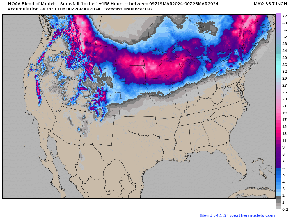
-
3/24-3/27 Midwest/Plains Colorado Low(s)
Minny_Weather replied to Minny_Weather's topic in East of the Rockies
I hope it continues that way. A southward trend would be a huge slap in the face to a lot of people in Minnesota.


