Minny_Weather
-
Posts
10525 -
Joined
-
Last visited
-
Days Won
19
Everything posted by Minny_Weather
-

January 11-13 Major Winter Storm/Blizzard
Minny_Weather replied to Hoosier's topic in East of the Rockies
Pretty disheartening how far east this thing shifted. On one hand, I'm glad it'll be an easy drive to Duluth for me. On the other hand, the north shore just won't be the same without the foot+ of snow cover that's typically there when I go in January. -
January 11-13 Major Winter Storm/Blizzard
Minny_Weather replied to Hoosier's topic in East of the Rockies
I'd be ecstatic if the Minnesota side of the CWA got anything at this point. Model trends are horrible -
January 11-13 Major Winter Storm/Blizzard
Minny_Weather replied to Hoosier's topic in East of the Rockies
Wow, absolutely terrible trends for Minnesota. -
January 11-13 Major Winter Storm/Blizzard
Minny_Weather replied to Hoosier's topic in East of the Rockies
Good news is this storm looks like it'll fill in the gaping snowless hole in SE MN, including in the cities. That'll leave the southern Red River Valley as the only place in the state under 1". -
January 2024 Observations and Discussion
Minny_Weather replied to Minny_Weather's topic in East of the Rockies
Flakes fell pretty much all day yesterday and last night. Didn't amount to much, about an inch total, but keep piling it on. 0°F. -
January 11-13 Major Winter Storm/Blizzard
Minny_Weather replied to Hoosier's topic in East of the Rockies
Yup, my drive on Friday night is not going to be a fun one -
January 11-13 Major Winter Storm/Blizzard
Minny_Weather replied to Hoosier's topic in East of the Rockies
Dang, looking like this might make my Friday night drive to Duluth interesting. -
January 2024 Observations and Discussion
Minny_Weather replied to Minny_Weather's topic in East of the Rockies
NAM, which was the last remaining model to give me a multi-inch snowfall with the fropa tomorrow, has dried up. Euro still gives me >2", but I don't trust Euro in the short range. -
The North Shore got ultimately hosed much like they have all winter- not even lake enhancement could save them. The highest totals in the entire Duluth CWA was actually in and near Brainerd. Duluth got 0.3", bringing their seasonal total to 12.3", while their season to date normal is 40.7" (which they were way above last year). Wichita, KS has 2" more snow than Duluth this season, despite their season-to-date normal being 10% of Duluth's.
-
Hey, I see me on that map! A bit surprised to see 6-8" reports just a few miles to my SE. I know I didn't get 4" like that map would seem to indicate - I cleared maybe 2-3" off my car.
-
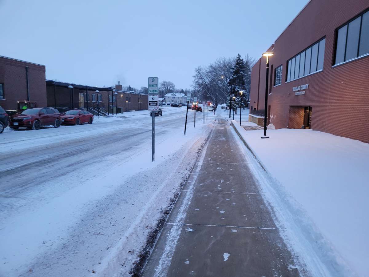
My view as I walked into work this morning. Once again, though my total from this storm wasn't impressive at all, at least it looks winter-y.

-
Wow, I-70 is closed all the way from the edge of the Denver metro to Junction City, KS.
-
January 2024 Observations and Discussion
Minny_Weather replied to Minny_Weather's topic in East of the Rockies
The EPS MEAN (not just one member) calling for a Barney rampage in MT and the Central Plains this weekend. The low for Cut Bank, MT shows as -38 in their grid on Friday night.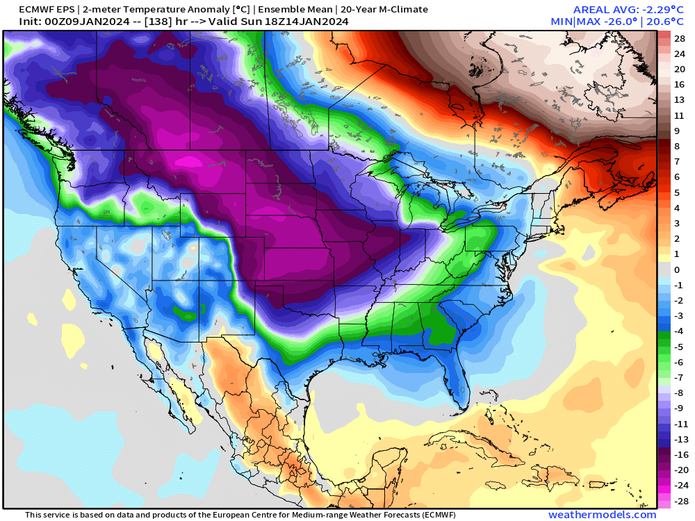
-
January 2024 Observations and Discussion
Minny_Weather replied to Minny_Weather's topic in East of the Rockies
Models are bringing back the idea of a clipper pattern. I'll believe it when I see it. The grass is (barely) covered thanks to this last storm so it finally looks like winter here in Lakes Country. Let's slowly pile on. -
Wow, the radar over Iowa right now is insane. Eastern Iowa is going to see some out of this world totals.
-
Wow, that's just mesmerizing to look at.
-
January 2024 Observations and Discussion
Minny_Weather replied to Minny_Weather's topic in East of the Rockies
I've pretty much resigned myself to the fact that a decent snow cover, if I get one this winter, will be achieved through nickel and dimers. Which is why I like NAM's solution for Wednesday's clipper up here. Unfortunately, it is a moist outlier at the moment. It gives me and even more snow-starved areas to my west and northwest 3", while other models struggle to give us 1". -
I was just wondering where you went yesterday lol
-
The dry air has filled in and I'm finally getting some better sized flakes. I haven't had the means to measure, but I'd be surprised if I've gotten a half inch since it began snowing at noon. 21°F.
-
If I get over an inch from this I will be shocked. Dry air is being a b!tch. The previously good areas of SW MN might get screwed here, too. The fact that Euro is the only model still on my side isn't encouraging
-
January 2024 Observations and Discussion
Minny_Weather replied to Minny_Weather's topic in East of the Rockies
I know Fargo's latest on record WAS December 31. Kinda surprised me and seems like it was a rather low-hanging fruit to beat. -
January 2024 Observations and Discussion
Minny_Weather replied to Minny_Weather's topic in East of the Rockies
Yeah, I feel that. I didn't expect to get hit by a CO low in January despite what models were saying, but definitely disappointed that we lost the clipper train. Thankfully it's cold enough here to hold 3" of snow on the ground cuz it looks like that's all I'll have for the foreseeable future. I'd be going nuts if I still lived in ND, what a terrible winter there. -
Hope it stops. That gets me dangerously close to another futile dusting.
-
Less than 24 hours to onset and I have some models giving me borderline warning snow and some giving me under an inch. Lovely!
-
January 2024 Observations and Discussion
Minny_Weather replied to Minny_Weather's topic in East of the Rockies
Fargo is finally going to receive its first subzero reading this upcoming week. The previous lowest temperature this season was +1°F back in November. The latest first subzero reading on record there previously was on December 31, 1987. Needless to say they smashed that record.