


Hawkeye
-
Posts
7165 -
Joined
-
Last visited
-
Days Won
17
Posts posted by Hawkeye
-
-
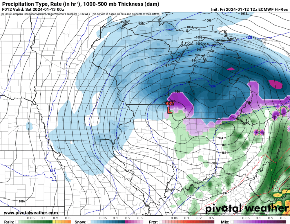
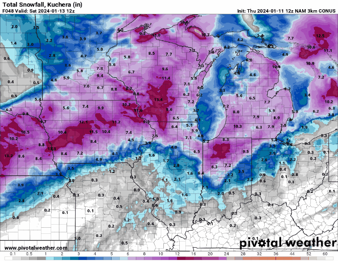
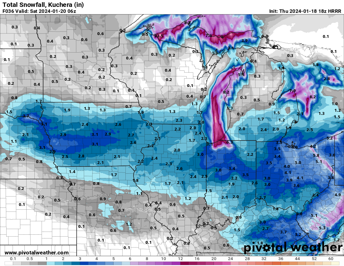
Radar shows most of the snow sagging into southern Iowa. The latest HRRR/RAP have dropped Cedar Rapids down to only 1-2".
-
-
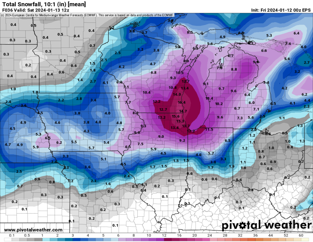
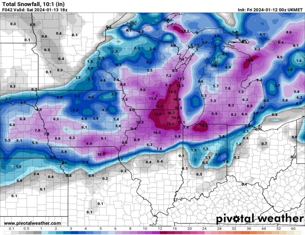
12z Euro has snow, but it's weakish.
-
For days, models showed all rain here. Recent runs have certainly trended colder and snowier.
-
 6
6
-
-
Several models have sagged south this morning... tracking the snow band through southeast Iowa.
-
2
-
-
00z Euro has juiced up a bit more through Iowa.
-
3
-
 1
1
-
-
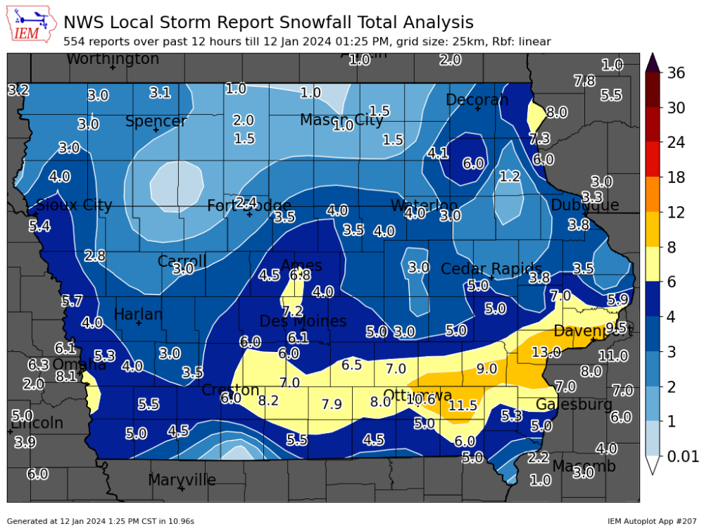
Other spotter/Cocorahs reports from Cedar Rapids are in the 6-8" range, but I'm just going to record 5". My snow board only has 2.5" on it this morning, but the liquid is 0.43. Extrapolated to 5", that's 0.80" and a 6 to 1 ratio. This always happens when the snow is dry and the wind is strong. The dry snow should have a relatively high ratio, but it's ends up being 5 or 6 to 1 for me.
-
3
-
-
More good snow is blowing up across the Quad Cities area. They may end up with 15+".
-
Another three hours of snow produced only about 0.1" on my snow board, so my measurement is worthless. I'll probably just record 5" or whatever the local average is.
-
Snow is vanishing from radar around Cedar Rapids, but somehow it's still going strong in the Des Moines area. Is it just me or does Des Moines hit the jackpot almost every storm?
-
1
-
-
47 minutes ago, Iowawx said:
How much longer should the accumulating snow last in CR? Should the snowfall rate pick up as the day goes on?
The HRRR has the snow lasting til 10pm, but it will gradually weaken. Current radar shows it's already weakening over Cedar Rapids and the heavier snow shifts east.
Despite getting pretty good snow for the last two hours, there is only another 0.7" on my board. My total so far is a lousy 3.3". At this rate it will be difficult just to finish with 5". We got bulls-eyed by the early-week storm. Unfortunately, it goes the other way, too.
-
1
-
-
13" in Muscatine. Davenport should exclipse 12" shortly.
-
3
-
-
46 minutes ago, Tom said:
The double barrel low was horribly modeled...I don't recall every seeing the Euro showing it tracking over Chicago. What a gut punch! It always had a consolidated low in N IN into S MI...
The 500 mb energy that is producing this system is pretty messy. The models have struggled with the details. For the last few days it looked like southwest through all of northern Iowa would get hit hard. However, it is southern Iowa that got hit hard while northern Iowa appears to be busting badly.
-
2
-
-
I am at about 2.6" now, a pretty underwhelming first half of the storm. My two small snow boards only have 1" on them, so the wind is clearly blowing the snow off the boards. My main board, with the backstop built up around the south side, has 2.6". The snow has been a bit light so far, but it's getting heavier.
-
1
-
-
9 minutes ago, bud2380 said:
Eye balling looks like 1” here. North Liberty has a report of 4.5” and I don’t believe that for one second.
I have three snow boards out. Because snow tends to blow off my boards, I backstopped my main board by adding an incline around its south side, hoping that would help keep snow on the board a bit better. The other two boards are just sitting on a flat area. The main board has 1.7", the other boards have 1.0" and <0.5".
-
1
-
-
Maybe 1.5" here. The model trend was correct, unfortunately. Southern Iowa got hit hard overnight, with 5-6" totals from Omaha to Des Moines to Ottumwa to the Quad Cities, but the snow really crapped out as it headed north toward highway 30. At this point I'm just hoping for 5" total.
-
 1
1
-
-
3 hours ago, Hoosier said:
00z Euro is brutal out in Hawkeye's area.
Sheesh... after greatly improving for the previous two runs, the Euro just totally pulled the rug out from under Cedar Rapids/Iowa City. It basically has the storm splitting around us now. The UK did the same thing tonight. Now the 06z NAMs have both cut us way down. The EPS mean also just cratered for Iowa. I'm suddenly very worried about this.
-
The UK just dropped a turd on Iowa.
-
Another trend is for tonight's surge of good snow to mostly veer east of my area, with northern Illinois getting the heavy stuff. I may only get an inch or two through morning.
-
-
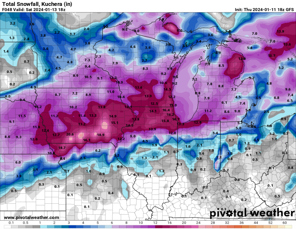
The trend had been great for my area, but the the 00 NAMs went the other way...
 . The 3k NAM has really dried out for the Omaha to northern Iowa corridor.
-
1
-
-
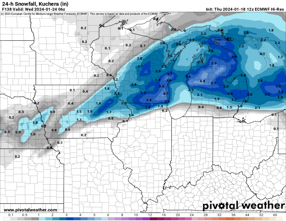
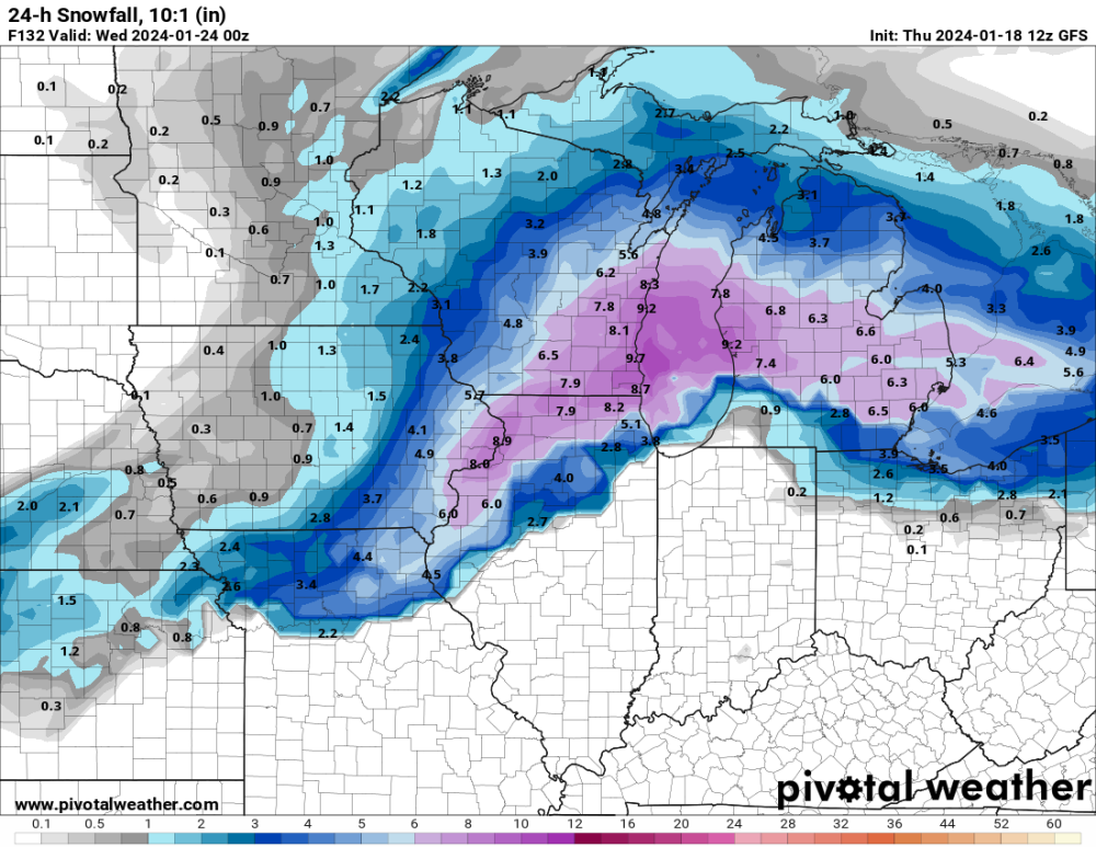
Today, the Euro has shown a significant trend toward increasing snow across eastern Iowa. The 06z run had a dry hole over us. 12z filled the hole. 18z is even wetter. As with a few other models, there is a trend toward extending the low farther west and blowing up heavier precip over east-central/southeast Iowa.
-
 1
1
-
-
1 minute ago, FV-Mike said:
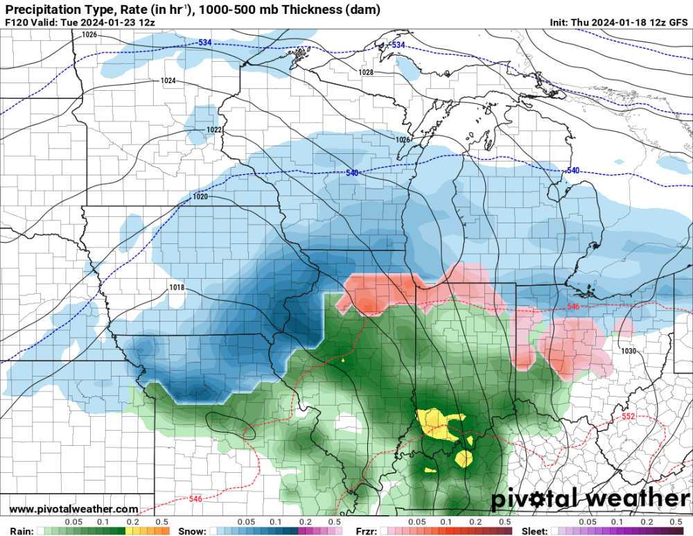
Could someone post the 18Z GFS for points further East. Thanks!
-
2
-
 1
1
-
-
3 minutes ago, Hoosier said:
Seeing some tendency to elongate the surface low a bit more as it heads toward the Lakes. Whether this will actually occur or if we see a stronger/more consolidated center, no clue.
The models that are elongating it farther west are the ones that dump more snow here, so I hope they are correct.


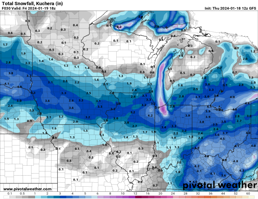
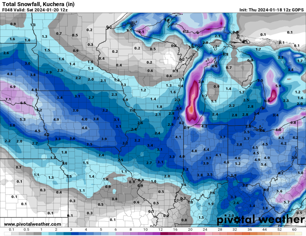
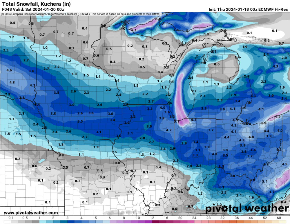
January 17-19 Plains-Midwest Snowfall
in East of the Rockies
Posted
It appears Des Moines got bulls-eyed yet again. There is a report of 4.5" near the city.