


Hawkeye
-
Posts
7252 -
Joined
-
Last visited
-
Days Won
17


Hawkeye's Achievements
")


-
We got our first lightning and thunder since August, but still no measurable rain. The line shot through very quickly and the air is way too dry.
-
Recent op GFS runs have been very dry into early November. However, the GEFS and EPS are wetter, and the AI Euro has trended very wet across my area in the 10-15 day period. I sure hope it's right. We need some soakers to replenish the soil before winter.
-
Fall 2007 was nothing like this, precip-wise. My records show regular rain events through September and October, adding up to above average rainfall. October had three 1.25+" rain events.
-
It's looking like a hard freeze Tuesday night. The NWS has lowered our low to 26º. Bye-bye garden.
-
Models (especially the AI Euro) have teased a pattern change with a cold blast and some rain later in October, but they keep backing off/pushing it back.
-
GFS and Euro..... both show ZERO rain for the next ten days. This may be the driest period in my entire lifetime. If I want months of no rain, I'd move to San Diego. This is beyond ridiculous.
-
It is way too warm for mid October. Also, it seems it is never going to rain again. This pattern needs to end.
-
Cedar Rapids got down to 35º this morning. It was a bit less cold here in the city. A few spots in northeast Iowa hit 32º and a couple spots in western Iowa hit 30º.
-
The Cedar Rapids airport finally got a bit of rain overnight (only 0.05"). This is the first measurable precip since late August. I did not put my gauge out, but none of the nearby personal stations recorded any rain. The atmosphere is just too dry.
-

September 2024 Observations and Discussion
Hawkeye replied to westMJim's topic in East of the Rockies
Massive bust here. I was lucky to get 0.09". The rest of September looks dry. At least the heat is gone. -
September 2024 Observations and Discussion
Hawkeye replied to westMJim's topic in East of the Rockies
The short-term models are not looking very good for my area tonight. It's possible we could get little to nothing. This may be our last chance of rain this month. I hate this pattern. -
September 2024 Observations and Discussion
Hawkeye replied to westMJim's topic in East of the Rockies
Last night's rain event was a bust around here. The weekend event continues to drift south. We will have to get rain from the initial front Saturday evening. The Euro has been the most bullish for me, but I'm on the edge now. The AI Euro has consistently been south.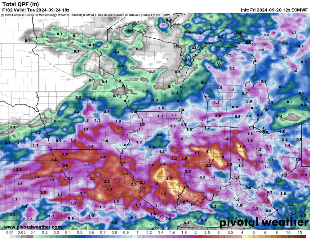
-
September 2024 Observations and Discussion
Hawkeye replied to westMJim's topic in East of the Rockies
The weekend to early week system took a pretty good jump south on the new EPS. -
September 2024 Observations and Discussion
Hawkeye replied to westMJim's topic in East of the Rockies
I wouldn't put any money on this. The latest 06z GFS took almost all of the rain away from Iowa. Models are hinting that the strong low to the north will sweep everything to our south and keep it there. The AI Euro has been south for days. This desert-like weather pattern sucks. -
September 2024 Observations and Discussion
Hawkeye replied to westMJim's topic in East of the Rockies
Davenport dropped to 38º this morning. We reached the low 40s.


