


Hawkeye
-
Posts
7173 -
Joined
-
Last visited
-
Days Won
17
Posts posted by Hawkeye
-
-
5 minutes ago, KTPmidMO said:
Does anyone have a good radar that they use? Want something that reflects good. What does everyone use?
COD
https://weather.cod.edu/satrad/nexrad/index.php?parms=EAX-N0Q-1-12-100-usa-rad
-
 1
1
-
-
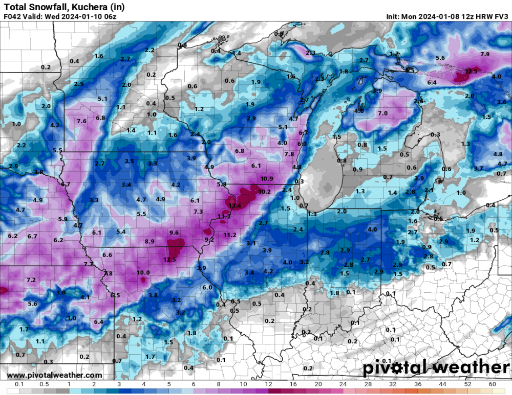
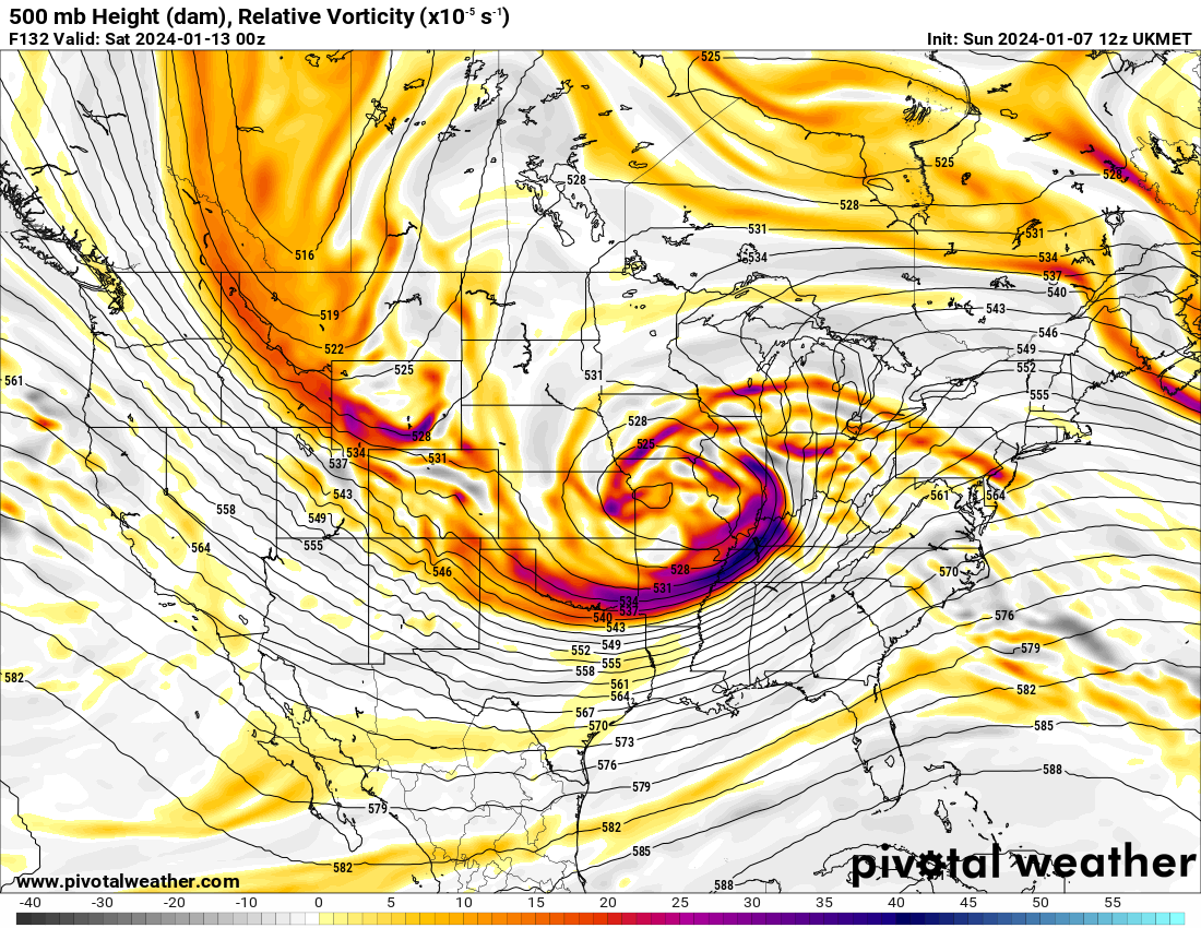
FV3 is southeast as well, much better for KC. In general, models are also dropping totals across northern Iowa.
-
 1
1
-
-
I'd say the 12z HRRR is a bit over-juiced.
-
 1
1
-
 1
1
-
 1
1
-
-
Euro sliding a bit too far east for Iowa, but it's going big.
-
22 minutes ago, jcwxguy said:

That map goes through Thursday morning and includes the next wave of snow not associated with this storm.
-
The GDPS continues to not even show warning snow across eastern Iowa.
-
1
-
-
This ICON run simply has the short wave flying eastward way too quickly. It needs to dig more and slow down.
-
1
-
-
21 minutes ago, jcwxguy said:

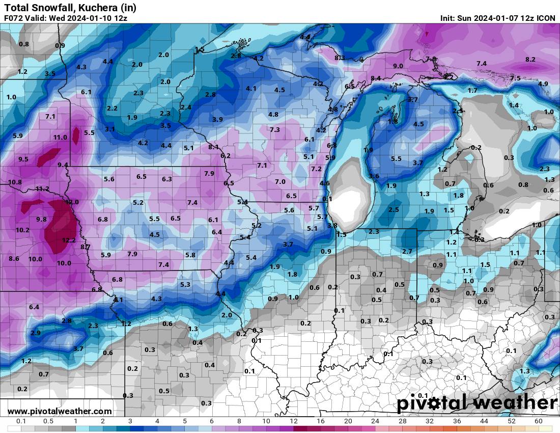
I'm not sure how the model blend is coming up with 11" in Cedar Rapids. I don't think there is a single model showing that much. Using Kuchera, most models are 6-7".
-
That's interesting how the HRRR has shifted the heaviest snow band northwest of Cedar Rapids.
-
1
-
-
The one negative on the new Euro is the digging energy is a bit broad, so it takes a while to wrap up as it cuts toward the lakes. A sharper short wave ejecting out of the southwest would lead to a bigger storm, earlier.
Despite a great surface low track, snow across Iowa is kinda meh.
-
3
-
-
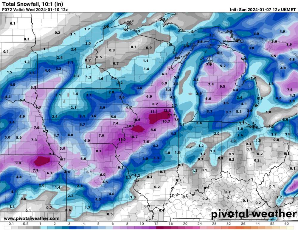
The UK, GDPS, and Euro all ticked back southeast this morning. The heavier defo zone snow may miss me to the southeast.
-
1
-
-
12z UK is back to a big hit for Iowa as the long wave trough is held farther west again.

-
4
-
 1
1
-
-
Models are not totally favorable for Cedar Rapids. The GDPS continues to track the main defo zone farther southeast and mostly misses us with it. Totals here are down on the 12z run. Likewise, the 12z UK is down as the best defo zone snow moves up through the Quad Cites.
-
The GFS is sliding the entire western trough eastward too much. The ICON and GDPS are anchoring the trough over the pacnw, which allows the storm to cut north into the upper midwest.
-
12z ICON... This run shows a weaker defo zone across eastern Iowa, so the totals have dropped by a couple inches.

-
1
-
-
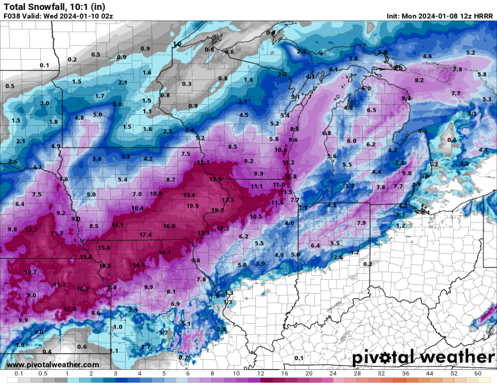
The 12z NAM drops totals across my area by 2-3", but it's probably noise. The 3k NAM is higher.
-
3 hours ago, Grizzcoat said:
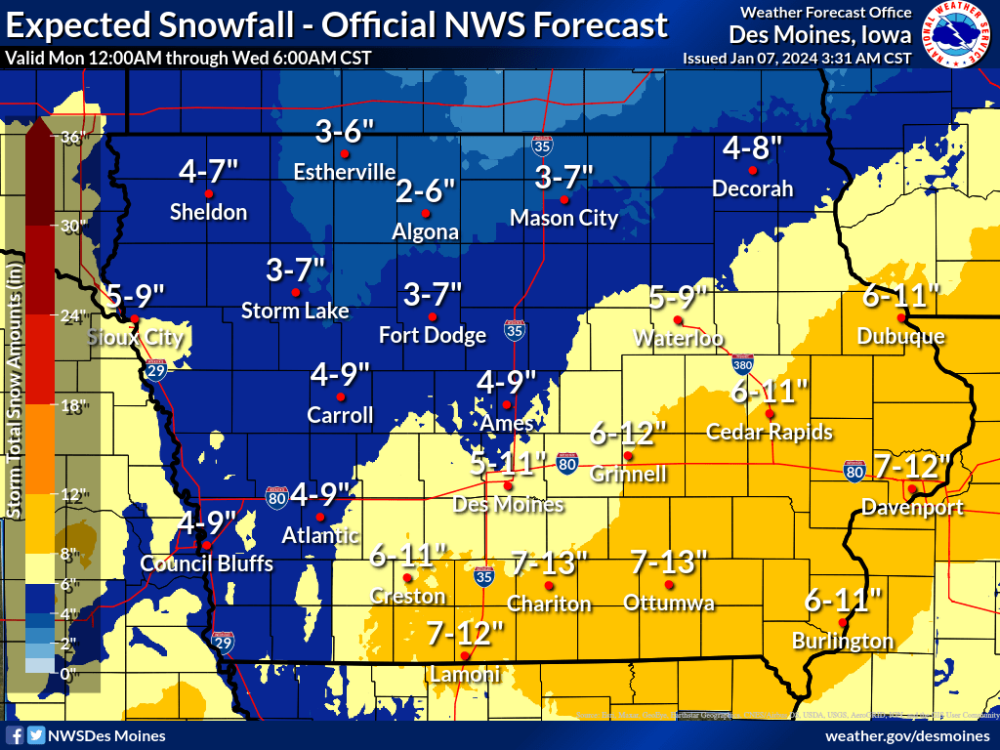
I'm pretty skeptical of the higher end of this range. I'm thinking more like 6-7".
-
1
-
-
19 minutes ago, Hoosier said:
The way that the 00z Euro is handling the weaker Thursday system so far *should* bode well for getting the biggie farther north of the 12z run.
The flatter lead wave is necessary, and it's back somewhat this run, but the storm wave also needs to slow down a bit and allow for some better ridging to pop in between the waves.
Edit: The storm wave just shoots eastward too quickly, can't amp up.
-
1
-
-
This is tough for Missouri. Days of excitement, followed by the rug getting pulled out, really sucks.
-
1
-
 2
2
-
-
The nws forecast is calling for 37º Monday and 34º Tuesday, so accumulation will likely be less than what models are spitting out for my area, especially considering most of our rates will be light to moderate.
-
The ICON continues to shift nw, unabated.
-
1
-
-
The NAM has the surface low tracking over Cedar Rapids... hundreds of miles northwest of all other models. C'mon, man. This is trash.
-
2
-
-
I can't imagine the upper low is going to track over Kansas City, as the NAM is predicting. Other models track it from Oklahoma to southeast Missouri.
-
6
-
-
Given the latest ensemble averages, it's looking like 5-7" here.
-
3
-


1/8-1/10 Panhandle Hook
in East of the Rockies
Posted
I've learned to be conservative. I'm discounting the higher end of the range being pushed by the NWS and local mets. I'll go with 6-8" for Cedar Rapids.