


gabel23
-
Posts
2306 -
Joined
-
Last visited
-
Days Won
5
Posts posted by gabel23
-
-
61KT gusts at both Norfolk and Wayne in the last hour. Heck-- these are stronger winds , or on par, with what Matthew delivered to the E Coast.
PRELIMINARY LOCAL STORM REPORT
NATIONAL WEATHER SERVICE OMAHA/VALLEY NEBRASKA
831 PM CST SUN DEC 25 2016
..TIME... ...EVENT... ...CITY LOCATION... ...LAT.LON...
..DATE... ....MAG.... ..COUNTY LOCATION..ST.. ...SOURCE....
..REMARKS..
0827 PM NON-TSTM WND DMG 2 NNE NORFOLK 42.06N 97.40W
12/25/2016 MADISON NE PUBLIC
LARGE LIMBS BLOWN DOWN. POWER TRANSFORMERS ON FIRE.
-
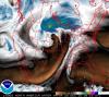
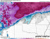
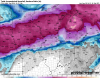
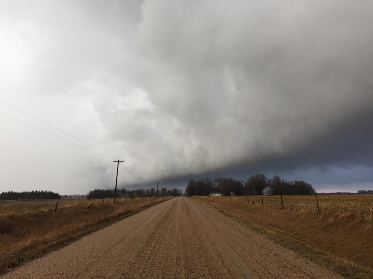
Impressive water vapor image, my christmas lights where taken out by the strong winds!
-
Grand Island just had a 65kt (75mph) wind gust
.KGRI 260053Z 10SM 04/M01 A2934 RMK AO2 PK WND 21065/0035 SLP950 T00391006 $
And Hastings had this, wow. I'm telling you, I have never heard such a roar out there........we are directly under the ULL.
PRELIMINARY LOCAL STORM REPORT
NATIONAL WEATHER SERVICE HASTINGS NE
714 PM CST SUN DEC 25 2016
..TIME... ...EVENT... ...CITY LOCATION... ...LAT.LON...
..DATE... ....MAG.... ..COUNTY LOCATION..ST.. ...SOURCE....
..REMARKS..
0641 PM NON-TSTM WND GST HASTINGS NWS OFFICE 40.65N 98.38W
12/25/2016 M71 MPH ADAMS NE OFFICIAL NWS OBS
71MPH WIND GUST MEASURED ON OFFICE DAVIS STATION.
-
Don't think anybody will be out and about in North Dakota..........
-
Very strong pressure, I'm currently at 29.37". I have just been included in the high wind warning, it's hollowing. I couldn't imagine what it would look like if it were snowing.
URGENT - WEATHER MESSAGE
NATIONAL WEATHER SERVICE HASTINGS NE
634 PM CST SUN DEC 25 2016
NEZ041-048-049-063-064-076-260600-
/O.EXB.KGID.HW.W.0002.000000T0000Z-161226T0600Z/
NANCE-MERRICK-POLK-HAMILTON-YORK-CLAY-
INCLUDING THE CITIES OF...FULLERTON...GENOA...CENTRAL CITY...
STROMSBURG...OSCEOLA...SHELBY...POLK...AURORA...YORK...SUTTON...
HARVARD...CLAY CENTER...EDGAR...FAIRFIELD
634 PM CST SUN DEC 25 2016
...HIGH WIND WARNING IN EFFECT UNTIL MIDNIGHT CST TONIGHT...
THE NATIONAL WEATHER SERVICE IN HASTINGS HAS ISSUED A HIGH WIND
WARNING...WHICH IS IN EFFECT UNTIL MIDNIGHT CST TONIGHT.
* TIMING...THROUGH MIDNIGHT TONIGHT.
* PEAK WINDS...SUSTAINED WINDS OF 35 TO 45 MPH WITH GUSTS UP TO
70 MPH.
* IMPACTS...TRAVEL WILL BE HAZARDOUS. SUDDEN WIND GUSTS COULD
CAUSE VEHICLES TO SWERVE OR LOSE CONTROL...ESPECIALLY HIGH
PROFILE VEHICLES AND LIGHT WEIGHT TRAILERS.
PRECAUTIONARY/PREPAREDNESS ACTIONS...
A HIGH WIND WARNING MEANS A HAZARDOUS HIGH WIND EVENT IS EXPECTED
OR OCCURRING. SUSTAINED WIND SPEEDS OF AT LEAST 40 MPH OR GUSTS
OF 58 MPH OR MORE CAN LEAD TO PROPERTY DAMAGE.-
 1
1
-
-
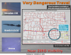
This storm is a beast, you have high winds, ice storm, blizzard and flooding. I feel for the people in Aberdeen......
Flash Flood WarningFlash Flood Warning
SDC013-260615-
/O.NEW.KABR.FF.W.0007.161226T0013Z-161226T0615Z/
/00000.0.RS.000000T0000Z.000000T0000Z.000000T0000Z.OO/
BULLETIN - EAS ACTIVATION REQUESTED
Flash Flood Warning
National Weather Service Aberdeen SD
613 PM CST SUN DEC 25 2016
The National Weather Service in Aberdeen has issued a
* Flash Flood Warning for...
Rain and Snowmelt in...
Brown County in northeastern South Dakota...
* Until 1215 AM CST Monday
* At 606 PM CST, local law enforcement officials reported flooding
over several major intersections in the city of Aberdeen in the
warned area. Over an inch of rain has already fallen, and when
combined with melting snow in town, additional flooding problems
are expected over the next several hours. Flooding is already
occurring.
Additional rainfall amounts of up to a half inch are possible in the
warned area. Other cities within Brown County may experience the
same problems, especially in low lying areas and near rivers,
streams and creeks.
PRECAUTIONARY/PREPAREDNESS ACTIONS...
Excessive runoff from heavy rainfall and melting snow will cause
flooding of small creeks and streams, urban areas, highways, streets
and underpasses as well as other drainage areas and low lying spots. -
-
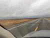
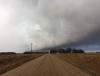
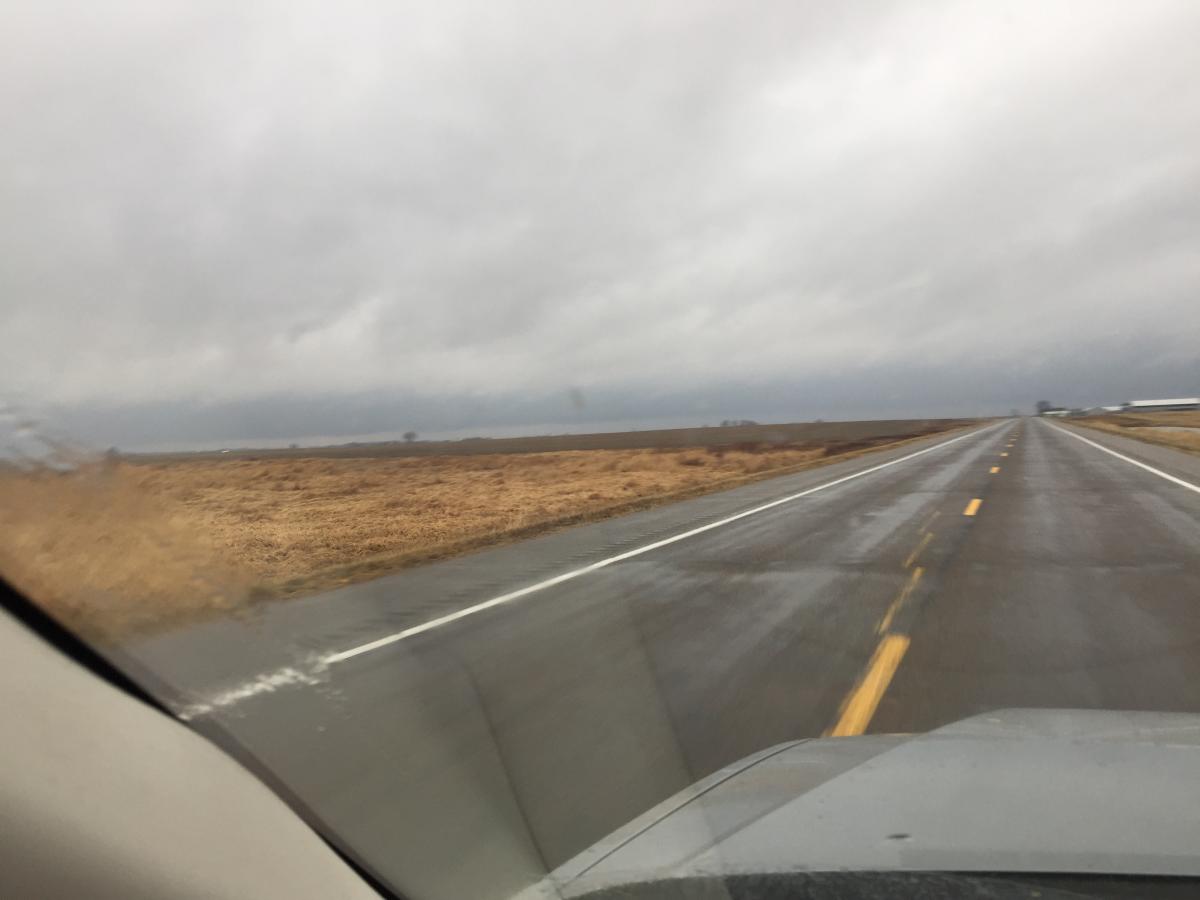
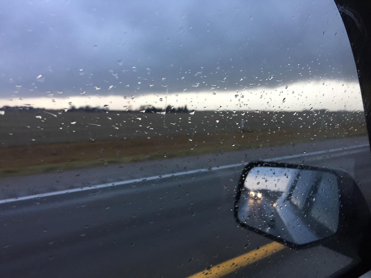
Well, I have now experienced a blizzard on christmas (2009) and now a shelf cloud with very strong winds and torrential rain! It was very impressive seeing this in December!!

-
1
-
-
Bah Humbug! I'm not to thrilled to have another brown Christmas for the 3rd straight year. Depending on how the impending warm cutter evolves, the snow pack may hold through Christmas day but most likely will take a huge beating. This high ratio fluff will get nuked by the warm surge. Over the past few days, I've been trying to enjoy the scenery around here as much as possible before its gone. The December Thaw is on it's way....

We might get to experience severe weather this year.....last year we saw this:
** Christmas 2015 Weather Recap (Christmas Thunderstorms!): In terms of weather, last Christmas was by far the most "interesting" one in the Grand Island area since the significant blizzard of 2009. Although most of the day was simply cloudy with a seasonably chilly high temperature of 31°, the evening hours featured a winter rarity as a narrow corridor of thunderstorms developed over the area and dropped a mix of snow, graupel (snow pellets), and freezing rain. Officially, the total snowfall for the day was only 0.6", but the overall-precipitation total of 0.17" was good for the 3rd-wettest Christmas on record! **
Hopefully by late December and into January we can start to experience some share the wealth storms. One this is for sure, if we can get a negative AO with the next go around in the LRC look out for a lot of us!!
-
Wonder how this one is going to miss us?! I'm guessing won't be as strong of a storm as being shown.....this would be a Christmas miracle for a lot of people though. Valley mentioned it in their discussion today.
The EC/GFS/Canadian agree on a potential winter storm for
Christmas Day. The GFS is farther south and keeps OMA on the
northern fringe of the snow, however the 00Z EC has an open system
and allow the moisture to advanced northward into the Dakotas. The
EC has a 180mi wide heavy snow swath centered north over SUX,
while the GFS has a narrower heavy snow swath 80 to 100mi wide
centered 225 miles south closer to TOP. the 12Z EC is even more
robust with the heavy snow and a little farther northwest than the
previous run. The Canadian also has more development farther north
than the GFS covering more of our forecast area with snow.
This far out and a lot can change, however will want to pay
attention to the forecast for Friday night through Sunday for
those traveling over the holidays.
&&
.AVIATION...(For the 18Z TAFS through 18Z Monday afternoon)
Issued at 1110 AM CST Sun Dec 18 2016
Look for VFR conditions through the period. There will be some
clouds above 9000 feet this afternoon.
&&
.CLIMATE...
Issued at 315 PM CST Sun Dec 18 2016
We broke the record low at Norfolk for both the 17th and the 18th as
temperatures bottomed out at -24F this morning (previous records:
18th was -19 in 1983 and for the 17th -15 1981 (new record for
the 17th -16). Omaha`s low this morning was -11 and Lincoln`s -12,
so these did not break the records from 1983 which were -18.
It could have been worse...the coldest low this morning across
the U.S. was -37 deg F at Aberdeen, SD. They also set records for
Dec. 17th and 18th.
-
1
-
-
I'm impressed with the depth of the snow pack for the northern tier at this point in the cold season...usually something you see in January and not December...
http://www.nohrsc.noaa.gov/snow_model/images/full/Upper_Midwest/nsm_depth/201612/nsm_depth_2016121805_Upper_Midwest.jpg
That's a large swath of 10"+ snow depth..... I couldn't imagine some of the drifts after there two blizzards.
-
1
-
-
All the ensembles are showing a super wet system and the potential is there for a Christmas Miracle storm...
This would be crazy! 4 storms in a row with no blocking and a positive AO......I can't imagine what could happen during the next cycle if we can get those two to go negative.
-
You get crushed on the 12z, just cuts way to hard for eastern NE. Hopefully we have something to track for the 4th week in a row.
Can you post snow map when you get a chance?! Thanks, it looks to me like this run has central and western Nebraska getting crushed. This would be crazy to have 4 storms in a row to track.......you would think we could get hit by one of them.....
-
Big snowstorm on the Euro for Christmas day for NE/IA/MN/WI.
12+ inches.
Map??
-
Wow it must be ripping in kc! You guys need to check out espn 2 and the division 2 championship game.....nothing better than playing for a title in the snow.
-
How is the snow falling in NE?? Looks pretty decent on radar as the defo band gets going.
1.5" here of straight pixy dust. Blowing around pretty good and the freezing drizzle from last night has put a nice glaze down everywhere. It's extremely slick around town. I'm happy that I at least got something.
-
1
-
-
Anybody have the EURO snowfall??
-
Streets and sidewalks extremely slick here. Most activities, games, etc. are cancelled tonight. Nothing like freezing drizzle to screw everything up. So now if it snows the 1-3 inches they predict it will be extremely slick underneath. Obviously traveling anywhere in the next 48 hours will be dicey.
Nothing here yet.....our b ball game got postponed though to another date. I was checking out web cams and they are completely iced up.
-
The post Christmas storm still looks interesting. I seem to remember a Christmas storm 7 or 8 years ago that went from Arkansas north to Chicago. Anyone remember when that was?
http://www.tropicaltidbits.com/analysis/models/gfs/2016121606/gfs_mslp_pcpn_frzn_us_40.png
X mas blizzard of 2009. By far the best snowstorm we have seen in our area in quiet some time. That thing was massive, had blizzard warnings from Oklahoma all the way up to Minnesota. That would make up for the lackluster start for us in the central plains for sure!!
-
1
-
-
The cold behind this storm is very impressive with the positive AO. Sub zero highs for lots of people in the Midwest!
-
Defo bands are hard to predict and often are not known until the day of the event.
That's what I thought, it could be a sneaky day or just another day......
-
Which model you guys going with? The models are still confused with the deformation band.....that could drop 1-6 inches in my area. That includes one model showing nothing!!!
-
Is anybody else's national weather service page messed up?? The warnings are shown on the national page but not the local pages. The observations are also not shown.....,
-
Practically identical to it's map of (2) days ago! I could double-down on the EC winning this one!
Anybody have the snowfall map??


Christmas Holiday Major Storm System
in East of the Rockies
Posted
WOW!!
Current conditions at
Fair and Windy
42°F
6°C