


gabel23
-
Posts
2306 -
Joined
-
Last visited
-
Days Won
5
Posts posted by gabel23
-
-
12z GFS with a 983mb bomb in C NE!
http://www.tropicaltidbits.com/analysis/models/gfs/2016110912/gfs_mslp_pcpn_frzn_ncus_34.png
Classic late fall/early winter track. I'm loving the trends, if we can get about 2-4 weeks of active weather for this years LRC I will take it!!
-
 1
1
-
-
Very important next two weeks. This would be the last part of the LRC so hopefully we can have a southwesterly flow that can bring powerhouse storms to everyone on board. We have already seen that part of the LRC will be calm/big ridging out west, so these next two weeks will be vital when it comes to finishing up the LRC cycle.
-
2
-
-
Gary Lezak mentioned on his video this morning that the pattern is not good........the LRC might be against a good winter also. The way it looks to me is it will be an Ohio Valley/East Coast winter.
-
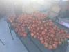
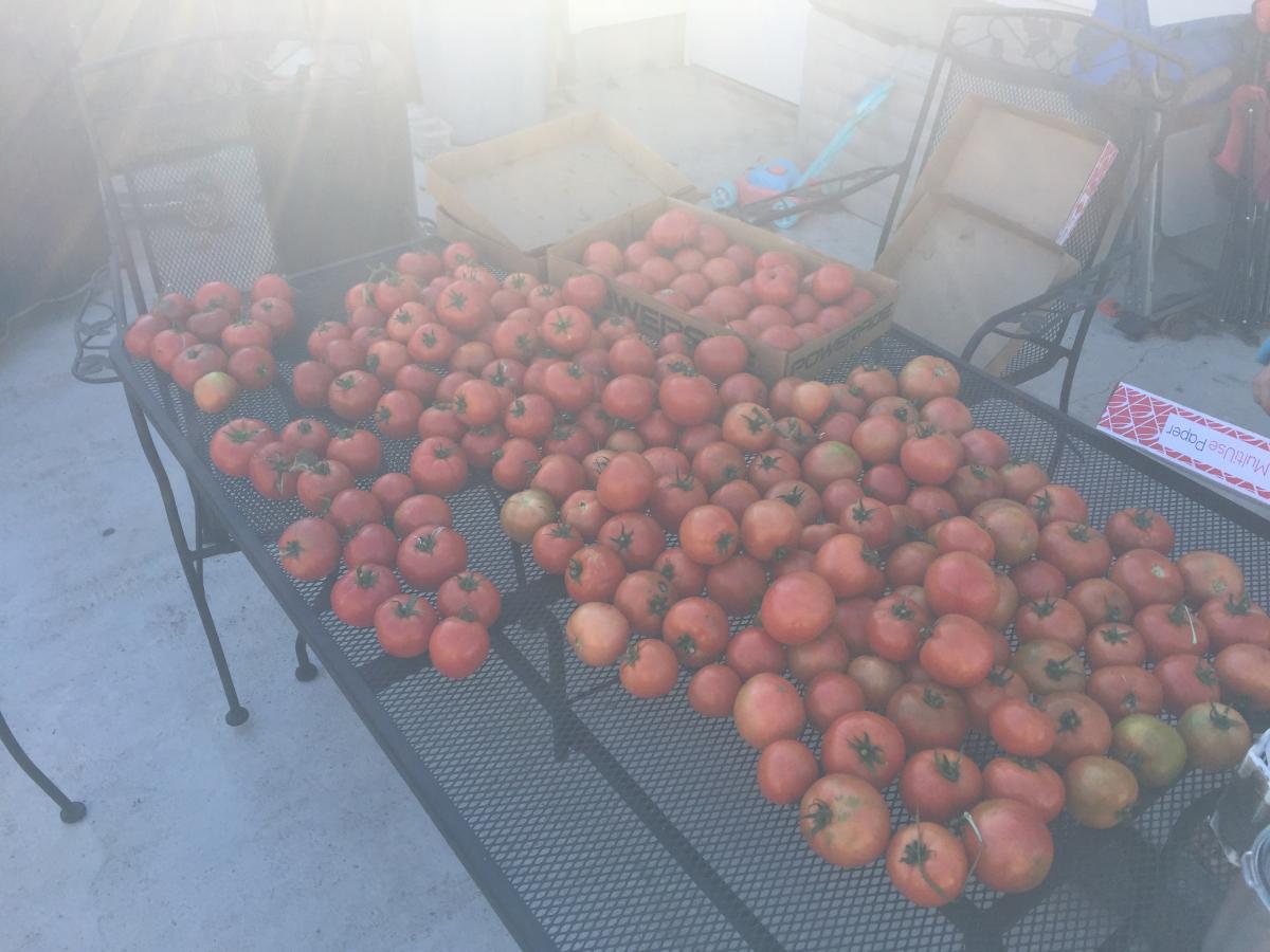
Holy macro! How big of a garden do you have? I bet your neighbors love you. Nothing tastes better than a fresh home grown tomatoe. Take advantage of the weather my friend.
I have a pretty decent size garden, I planted 8 tomato plants and as you can see they done real well this year! It was my first summer doing it because my wife and I purchased this house last July. I had to put the garden in myself, I'm thinking the chicken I put in when I tilled last fall helped a lot! I'm enjoying the weather, I'm ready for the white stuff though! I'm thinking the weather changes dramatically at or just after thanksgiving.
-
1
-
-
While we all wait for winter to approach, I just went out and picked more tomatoes. Can somebody tell my plants it's November??? I have been gardening for about 15 years, I have never had this many tomatoes this late!! They still taste and look like it's late summer.
-
Here is a pretty good link for you Nebraska peeps who want to go back and look at the daily variables from the past.
-
Dsm as of 3pm has tied the record of 75F set in 1909 for the 4th. This is getting old,-- last below normal month here was May of 15'. When will it end?
I was going through Lincoln, NE daily variables from 1983.......it's uncanny how much that year matches up with this year. For instance, from October 23-November 4th highs for that stretch were in the 60's. There were a few days that hit 70. We will find out whether or not 83-84' is a good analog or not.........major cold and snow struck around thanksgiving that year. We all want that year, Grizzcoat I'm pretty sure you were around for that winter weren't you?
-
October 2016 weather summary for Hastings NWS. I finished with 2.4" of precip for the month.
-
My area received a widespread soaker overnight. Models wavered in the 0.50-1.00" qpf range, but we ended up getting 1.41". It has been a very dry month, so it was welcome.
Neither the GFS nor Euro has another freeze chance through the first week of November. It's nice to see the flowers going so long.
And my tomato plants, at this rate I might have them for Thanksgiving!! We had one freeze, I covered my plants though and they survived.
-
Looks like a spilt flow to me.......mix that with a neutral NAO and a negative AO and I'm liking this year's LRC. Bowling ball lows is the wealth that gives to all on this forum..........Today's 12z EPS run firing up the western N.A. ridge during the first week of November, GEFS not as enthusiastic and keeps the trough in the GOA closer to shore. I also see that the EPS has a signal to keep the piece of the PV near Hudson Bay through Day 10, on the other hand, GEFS loose it by Day 7.
12z EPS Day 8...
http://www.tropicaltidbits.com/analysis/models/ecmwf-ens/2016102512/ecmwf-ens_z500a_namer_9.png
Day 10...
http://www.tropicaltidbits.com/analysis/models/ecmwf-ens/2016102512/ecmwf-ens_z500a_namer_11.png
12z GEFS Day 10...
http://www.tropicaltidbits.com/analysis/models/gfs-ens/2016102512/gfs-ens_z500a_namer_41.png
Closer look of the 12z EPS by Day 7 showing cold trying to knife down the leeward side of the Rockies. Each day it's showing a stronger cold signal.
http://www.tropicaltidbits.com/analysis/models/ecmwf-ens/2016102512/ecmwf-ens_T850a_us_8.png
-
For those of us who remember this, it was on this date in 1997 was the start of a snowstorm that buried all of Eastern Nebraska. There was another storm that I remember back in 91, which was the year of the perfect storm, that was much more like a true blizzard. The storm in 1997 was known for all the trees it killed because of the heavy, wet snow. Anyway, take a trip down memory lane!!
-
28° this morning. Frost everywhere.
Not quiet sure how cold it was this morning but I"m guessing it was somewhere around that here. There was frost all over my grass.......I'm hoping my tomato plants survived. I went out and checked this morning and they seemed fine so hopefully I can keep them around for another picking!! I put blankets over all of them last night.
-
Who's ready for some Indian Summer weather this weekend into early next week??? I think I'm going to be taking care of some yard work during this nice stretch.
http://www.tropicaltidbits.com/analysis/models/gfs-ens/2016101206/gfs-ens_T2maMean_us_4.png
The weather for Game 1 of the NLCS at Wrigley looks superb....@ Gabel, are you coming to Chicago to see a game or two???

I won't make it this year, I was lucky to have the chance of getting tickets last year! I did put my name in for the lottery drawing again but I doubt I get the tickets two years in a row.......That was an amazing game last night, GO CUBS GO!!
-
1
-
-
Go Cub's Go...Go Cub's Go....Hey Chicago whatd'ya say, we got another Blizzard on the way!! Haha...j/k...sounded good when I made that up...Good night ya'll!!!! October baseball is here!
Big three run homer by Arrieta tonight, great start lets get the sweep!! #FLY THE W!!!!!
-
2
-
-
Nebraska is off to a fast start. Nice. 5 inches for Oct 6? Lets keep it going.
Really impressive for the first week of October!!
000
NWUS53 KLBF 070417
LSRLBF
PRELIMINARY LOCAL STORM REPORT...SUMMARY
NATIONAL WEATHER SERVICE NORTH PLATTE NE
1117 PM CDT THU OCT 06 2016
..TIME... ...EVENT... ...CITY LOCATION... ...LAT.LON...
..DATE... ....MAG.... ..COUNTY LOCATION..ST.. ...SOURCE....
..REMARKS..
0306 PM SNOW 33 S MERRIMAN 42.44N 101.70W
10/06/2016 M5.0 INCH CHERRY NE BROADCAST MEDIA
0350 PM SNOW MULLEN 42.04N 101.04W
10/06/2016 E4.0 INCH HOOKER NE PUBLIC
0608 PM SNOW MERRITT RESERVOIR DAM 42.65N 100.87W
10/06/2016 M4.0 INCH CHERRY NE PUBLIC
0609 PM SNOW 16 SW MULLEN 41.88N 101.26W
10/06/2016 M4.5 INCH HOOKER NE PUBLIC
0609 PM SNOW 13 ENE TRYON 41.63N 100.71W
10/06/2016 M2.0 INCH LOGAN NE PUBLIC
0620 PM SNOW 30 S VALENTINE 42.44N 100.55W
10/06/2016 M5.0 INCH CHERRY NE TRAINED SPOTTER
0622 PM SNOW 1 S VALENTINE 42.86N 100.55W
10/06/2016 M3.0 INCH CHERRY NE OFFICIAL NWS OBS
0705 PM SNOW AINSWORTH 42.55N 99.86W
10/06/2016 E3.0 INCH BROWN NE CO-OP OBSERVER
-
2
-
-
I'm thinking it might be virga precipitation.

No, the snow out in the Panhandle of nebraska is reaching the ground believe it or not!
-
3
-
-
No way! What city?
Alliance, NE. It's located in the panhandle of Nebraska. This storm today has a classic spring time look to it, minus the fact that it's just a weak wave.
-
While there is a hurricane ready to make landfall, this is occurring out in western nebraska.......
Alliance, Alliance Municipal Airport (KAIA)Lat: 42.06°NLon: 102.8°WElev: 3927ft.http://forecast.weather.gov/newimages/large/sn.pngLight Snow Fog/Mist
33°F
1°C
Humidity 96% Wind Speed N 8 mph Barometer 30.12 in (1020.7 mb) Dewpoint 32°F (0°C) Visibility 1.25 mi Wind Chill 26°F (-3°C) Last update 6 Oct 10:49 am MDT-
1
-
-
Alliance, Alliance Municipal Airport (KAIA)Lat: 42.06°NLon: 102.8°WElev: 3927ft.http://forecast.weather.gov/newimages/large/sn.png
Light Snow Fog/Mist
33°F
1°C
Humidity 96% Wind Speed N 8 mph Barometer 30.12 in (1020.7 mb) Dewpoint 32°F (0°C) Visibility 1.25 mi Wind Chill 26°F (-3°C) Last update 6 Oct 10:49 am MDT-
1
-
-
Nebraska folks look to be in prime location for above normal snowfall this year according to Joe B
Where do you guys get his information from?? I would like to check out his information, thanks!
-
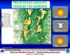
I ended with 2.00" of rain over the past two days. I'm hoping to avoid a hard frost as my tomato plants are still producing! Here is the rainfall estimates over the area. Not all were as lucky, but if this was the beginning to the LRC it was a good start!
-
Awesome. Can you tell me where or send me a link to where you made your map?
I just went to google and searched images. I typed in December 1983 surface air anomalies.
-
Brrrrrrrrr!!!!!!!!
-
1
-
-
How was 83-84 in your area?
One of the worse in my area and all of eastern Nebraska. A major blizzard started the winter off with 12" of snow thanksgiving weekend and another before Christmas lead to a streak of like 7 days below zero. I was born on the 21st of December........the high that day was -10 and the low was like -24. (I'm thinking that's why I love winter so much!)That winter makes 09-10 look like a joke...........I love the 83-84 analog.


November 2016 Observations & Discussion
in East of the Rockies
Posted
Doesn't look like much for the next week's storm but here is the complete run. One thing to take away, things might finally be switching to cold around these parts just in time for the holiday season!!