


gabel23
-
Posts
2306 -
Joined
-
Last visited
-
Days Won
5
Posts posted by gabel23
-
-
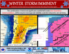
Probably the craziest thing from this storm was accuweather was spot on! They had my area receiving 3-6" of snow, and that was in their forecast 4 days ago!! Might have to start trusting in-accuweather!!
-
Gonna be tough to beat the ice bowl between the packers and cowboys......It's crazy to think about that bengals game though. A temp of -8 with winds gusting to 30 mph?! Man that would hurt getting hit!!
-
Here are some snow reports from the area. My official snow total comes from a person just northeast of town. He has been reporting for the NWS for years. I received 4.4" officially. Not a bad storm to say the least!
801
NWUS53 KGID 081654
LSRGID
PRELIMINARY LOCAL STORM REPORT...SUMMARY
NATIONAL WEATHER SERVICE HASTINGS NE
1054 AM CST FRI JAN 08 2016
..TIME... ...EVENT... ...CITY LOCATION... ...LAT.LON...
..DATE... ....MAG.... ..COUNTY LOCATION..ST.. ...SOURCE....
..REMARKS..
0600 AM SNOW 4 N HASTINGS 40.65N 98.39W
01/08/2016 M1.5 INCH ADAMS NE OFFICIAL NWS OBS
24 HR TOTAL THRU 6 AM. SNOWDEPTH 2 IN.
0620 AM SNOW 2 SSE HASTINGS 40.56N 98.38W
01/08/2016 M2.5 INCH ADAMS NE NWS EMPLOYEE
24 HR TOTAL THRU 6 AM. CORRECTED FROM 1SSE TO BETTER
REFLECT LOCATION.
0630 AM SNOW BRADSHAW 40.88N 97.75W
01/08/2016 M2.4 INCH YORK NE CO-OP OBSERVER
0648 AM SNOW 3 N YORK 40.91N 97.60W
01/08/2016 M2.4 INCH YORK NE CO-OP OBSERVER
0700 AM SNOW 1 S FAIRFIELD 40.42N 98.10W
01/08/2016 M3.5 INCH CLAY NE COCORAHS
0700 AM SNOW CLAY CENTER 40.52N 98.05W
01/08/2016 M3.2 INCH CLAY NE CO-OP OBSERVER
0700 AM SNOW MCCOOL JUNCTION 40.74N 97.60W
01/08/2016 E2.5 INCH YORK NE PUBLIC
PUBLIC REPORT VIA FACEBOOK.
0700 AM SNOW 3 NE SHELBY 41.22N 97.39W
01/08/2016 M4.4 INCH POLK NE CO-OP OBSERVER
0700 AM SNOW 2 NW OHIOWA 40.43N 97.48W
01/08/2016 M3.0 INCH FILLMORE NE COCORAHS
0700 AM SNOW 2 WSW TOBIAS 40.41N 97.37W
01/08/2016 M2.5 INCH FILLMORE NE COCORAHS
0700 AM SNOW 4 SSE HILDRETH 40.28N 99.02W
01/08/2016 M2.5 INCH FRANKLIN NE COCORAHS
0700 AM SNOW 4 SW BLADEN 40.28N 98.65W
01/08/2016 M2.0 INCH WEBSTER NE COCORAHS
0800 AM SNOW 3 SE HASTINGS 40.55N 98.35W
01/08/2016 M3.1 INCH ADAMS NE NWS EMPLOYEE
SOUTH SIDE OF HASTINGS HAD ROUGHLY TWICE AS MUCH SNOW AS
OFFICIAL OB AT NWS OFFICE JUST NORTH OF TOWN. -
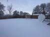
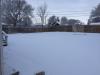
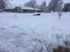
We received a solid 4" of snow. The first band yesterday afternoon laid down between 2-3" of snow and then over night we received another couple inches. Of course there was some compacting so it's hard to tell exactly how much I received. My snow depth is now at 7". I haven't seen a huge storm yet but that should come, we usually see our heaviest snow storms later in the winter. I just hope I can keep this snow on the ground, I'm going on three weeks with a snow depth greater than 2". Now bring on the cold! I must say, this is the first time I have had school called off and we weren't in any advisory or warning.
-
 2
2
-
-
Shouldn't surprise me, but NWS Hastings really cutting back on snow amounts here. I was in an area to get 4 inches and locally more and now it is saying maybe an inch if lucky. For as great as the potential looks, it never seems to verify in the amounts that are forecasted. You would think one of these would go our way in Central Nebraska. On to the next storm hopefully.
They have been way off all year, not quite sure what the deal is. I was surprised to see how hard it snowed! It started off as graupel or snow grains and transitioned into huge snow flakes! I couldn't believe how big the flakes were! we received around 3" of snow in about an hour and a half!
-
1
-
-
I found a pretty sweet website off of Aberdeen NWS's page that measures how severe your winter is for any location. It appears Wyoming is having a pretty severe winter so far. I can relate because I have seen Facebook pictures of snowdrifts 30' in places around Cheyenne. Will be interesting to see how it looks come April.....
Aberdeen's writeup of how the winter is going so far: http://www.weather.gov/abr/2015-16WinterUpdate
Winter Severity page: http://mrcc.isws.illinois.edu/research/awssi/indexAwssi.jsp#info
-
2
-
-
Some interesting write-ups about this storm.
Storm totals from Odessa, Tx: https://nwschat.weather.gov/p.php?pid=201512282218-KMAF-NOUS44-PNSMAF
Write-up from Lubbock: http://www.srh.noaa.gov/lub/?n=events-20151227-blizzard
-
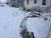
2.4" is the official count for my county, I have a current snow depth of 3" which means I received 2 from this storm. The one inch that was on the ground before this storm was nothing but ice. I'm hoping I can keep some of this snow until the next storm hits.
-
I'll be lucky to see 2" if it's that much further east.
-
It's currently 10 degrees in Columbus and the NWS is predicting a low of 8. I don't recall seeing this amount of cold air a couple of days ago. It will not take much to fluff up snow totals tomorrow, that really is my only hope of seeing anything significant.I'm just hoping things can hold serve and I'll gladly take 3-5" maybe more if things come together just right.....
-
Such a sharp cut off I hate it. I need not even a 3 mile shift to the west and I'm in the 6-8". It has been a frustrating past couple of days. Still waiting for the one "share the wealth storm" to occur for all of us. You have to admit though, it looks stupid with the WWA south of Columbus down to Hebron!!
-
Platte county, which is Columbus, has 6-10" being forecasted. I'm straight south of there and I have 3-5". The snow will be moving in from the south!! It doesn't make sense, sometimes I wonder what the hell Hastings is thinking.....
URGENT - WINTER WEATHER MESSAGE
NATIONAL WEATHER SERVICE OMAHA/VALLEY NE
333 PM CST SUN DEC 27 2015
...WINTER STORM MOVING INTO THE AREA ON MONDAY...
IAZ043-055-056-NEZ012-015-017-018-031>034-042>045-280545-
/O.UPG.KOAX.WS.A.0004.151228T1200Z-151229T1200Z/
/O.NEW.KOAX.WS.W.0006.151228T1200Z-151229T1200Z/
MONONA-HARRISON-SHELBY-CEDAR-THURSTON-PIERCE-WAYNE-MADISON-
STANTON-CUMING-BURT-PLATTE-COLFAX-DODGE-WASHINGTON-
INCLUDING THE CITIES OF...ONAWA...MAPLETON...MISSOURI VALLEY...
WOODBINE...LOGAN...DUNLAP...HARLAN...HARTINGTON...LAUREL...
RANDOLPH...COLERIDGE...PENDER...MACY...WALTHILL...WINNEBAGO...
PIERCE...PLAINVIEW...OSMOND...WAYNE...NORFOLK...STANTON...
WEST POINT...WISNER...TEKAMAH...OAKLAND...LYONS...DECATUR...
COLUMBUS...SCHUYLER...FREMONT...BLAIR
333 PM CST SUN DEC 27 2015
...WINTER STORM WARNING IN EFFECT FROM 6 AM MONDAY TO 6 AM CST
TUESDAY...
THE NATIONAL WEATHER SERVICE IN OMAHA/VALLEY HAS ISSUED A WINTER
STORM WARNING FOR SNOW AND BLOWING SNOW...WHICH IS IN EFFECT FROM
6 AM MONDAY TO 6 AM CST TUESDAY. THE WINTER STORM WATCH IS NO
LONGER IN EFFECT.
* TIMING...SNOW WILL SPREAD NORTH INTO THE AREA MONDAY MORNING
AND CONTINUE INTO MONDAY NIGHT. PERIODS OF HEAVY SNOWFALL ARE
POSSIBLE LATE MONDAY MORNING INTO MONDAY AFTERNOON.
* ACCUMULATIONS...SNOWFALL IS EXPECTED TO RANGE FROM 6 TO 10
INCHES ACROSS THE AREA WITH HIGHER AMOUNTS POSSIBLE.
* IMPACTS...TRAVEL WILL BECOME VERY HAZARDOUS. NORTHEAST WINDS
OF 15 TO 25 MPH ARE EXPECTED WITH HIGHER GUSTS. THE STRONG
WINDS WILL CONTINUE THROUGH THE EVENING CAUSING SIGNIFICANT
BLOWING AND DRIFTING SNOW. VISIBILITIES IN THE BLOWING AND
FALLING SNOW MAY BE LESS THAN A QUARTER OF A MILE AT TIMES. -
I'm so excited for another WWA....just goes to show you why you never live model to model!

The maps are going to look really funny, you will have WWA along highway 81 south of Columbus down to Hebron. Then warnings north and south of there from Columbus north and just south of Hebron into Kansas. Good old Hastings NWS!
URGENT - WINTER WEATHER MESSAGE
NATIONAL WEATHER SERVICE HASTINGS NE
301 PM CST SUN DEC 27 2015
...ACCUMULATION SNOWFALL EXPECTED IN SOME AREAS OF SOUTH CENTRAL
NEBRASKA AND NORTH CENTRAL KANSAS LATE TONIGHT THROUGH MONDAY
EVENING...
NEZ041-048-049-063-064-280600-
/O.UPG.KGID.WS.A.0005.151228T1200Z-151229T0600Z/
/O.NEW.KGID.WW.Y.0013.151228T1200Z-151229T0600Z/
NANCE-MERRICK-POLK-HAMILTON-YORK-
INCLUDING THE CITIES OF...FULLERTON...GENOA...CENTRAL CITY...
STROMSBURG...OSCEOLA...SHELBY...POLK...AURORA...YORK
301 PM CST SUN DEC 27 2015
...WINTER WEATHER ADVISORY IN EFFECT FROM 6 AM MONDAY TO MIDNIGHT
CST MONDAY NIGHT...
THE NATIONAL WEATHER SERVICE IN HASTINGS HAS ISSUED A WINTER
WEATHER ADVISORY FOR SNOW...WHICH IS IN EFFECT FROM 6 AM MONDAY
TO MIDNIGHT CST MONDAY NIGHT. THE WINTER STORM WATCH IS NO LONGER
IN EFFECT.
* TIMING...EXPECT SNOW TO DEVELOP AROUND 6 AM MONDAY AND THEN
DIMINISH AROUND MIDNIGHT MONDAY NIGHT.
* PRECIPITATION RATES...THE HEAVIEST SNOWFALL RATES WILL OCCUR
BETWEEN 10 AM AND 5 PM MONDAY.
* SNOW ACCUMULATIONS...TOTAL SNOW ACCUMULATIONS OF 2 TO 5 INCHES
ARE EXPECTED. HEAVIER SNOW AMOUNTS WILL BE ALONG THE HIGHWAY 81
CORRIDOR.
* WINDS / VISIBILITIES...LOOK FOR REDUCED VISIBILITIES AT
TIMES...AT TIMES LESS THAN 1 MILE.
* IMPACTS...PLAN ON SLIPPERY ROAD CONDITIONS...INCLUDING DURING
THE MORNING COMMUTE ON MONDAY. -
MON 12Z 28-DEC -10.7 -6.5 1026 63 56 0.00 558 538 MON 18Z 28-DEC -8.0 -7.7 1017 82 97 0.11 552 539 TUE 00Z 29-DEC -7.3 -9.9 1011 87 95 0.31 547 538 TUE 06Z 29-DEC -8.0 -10.6 1013 87 92 0.10 546 536 TUE 12Z 29-DEC -10.8 -10.9 1018 85 73 0.04 549 536
That would be 8-12" of snow if I get ratio's between 15-20:1. That would be nice.
-
And here is IOW (not looking bad but I believe the warm layer is around 750mb so still expecting ice, mainly sleet obviously)
MON 06Z 28-DEC -0.6 -2.3 1029 65 1 0.00 567 545 MON 12Z 28-DEC -0.7 -1.0 1021 77 100 0.10 564 547 MON 18Z 28-DEC -1.0 -1.4 1011 84 88 0.45 559 551 TUE 00Z 29-DEC -0.2 -2.5 999 91 94 0.56 541 542 TUE 06Z 29-DEC 0.0 -0.7 999 94 95 0.20 542 543 TUE 12Z 29-DEC -2.0 -6.7 1008 89 87 0.00 550 543 TUE 18Z 29-DEC -2.8 -6.3 1016 81 11 0.00 557 544
KOLU if you get a chance.
-
Omaha and Lincoln are still sitting good, not so much for me.
-
Civil Emergency Message
NMC005-011-019-271700-
BULLETIN - EAS ACTIVATION REQUESTED
CIVIL EMERGENCY MESSAGE
NEW MEXICO EMERGENCY MANAGEMENT AGENCY ALBUQUERQUE NEW MEXICO
RELAYED BY NATIONAL WEATHER SERVICE ALBUQUERQUE NM
700 AM MST SUN DEC 27 2015
THE FOLLOWING MESSAGE IS TRANSMITTED AT THE REQUEST OF LAW
ENFORCEMENT OFFICIALS IN EASTERN NEW MEXICO.
HIGH WINDS AND BLOWING SNOW HAVE LED TO EXTREMELY DANGEROUS AND
LIFE THREATENING CONDITIONS IN EASTERN NEW MEXICO...INCLUDING
CHAVES...DE BACA AND GUADALUPE COUNTIES. SNOW DRIFTS OF 4 TO 10
FEET COMBINED WITH LOW TO NEAR ZERO VISIBILITIES...WIND GUSTS
RANGING FROM 40 TO 60 MPH AND NEGATIVE WIND CHILLS ARE CREATING
EXTREMELY HAZARDOUS TRAVEL CONDITIONS. THERE ARE REPORTS OF
MULTIPLE STRANDED MOTORISTS AND EMERGENCY RESPONSE VEHICLES. DO
NOT ATTEMPT TRAVEL AT THIS TIME.
-
That is showing a 10:1 ratio, my area's high is forecasted around 19. I would say we could easily fluff up to 15:1, maybe higher.
-
all the models? I'm confused
The euro is further east tonight, pretty close to being in line with the nam, gfs, and gem. I really hope its a combo of the euro and nam, that really is the only chance I have of seeing anything significant.
-
The heaviest snow line has shifted eastward since last night. I'm right along the highway 81 cutoff, you guys in lincoln and omaha are sitting really good with all the models....the euro was the only model showing 6+ for the eastern edge of hastings CWA.
-
1
-
-
..
JC, could you post the digital output for that? It looks like 10+ for a lot of us.....You have to like the consistency!
-
I have a bad feeling not gonna lie, tough to believe euro would out do the other 4 models.....
-
Wow I hope the gfs is out for lunch, just won't budge! Long live king euro and go huskers!!
-
2
-
-
Not to jinx it but this thing is coming together stronger than advertised in my opinion......I think models tonight will have some surprises for us.


1/16 - 1/17 Plains/Midwest Arctic Front & Frontal Snows
in East of the Rockies
Posted
Accu weather has 1-3" of snow for my area. The only weather media outlet that has really a chance for snow.