


gabel23
-
Posts
2306 -
Joined
-
Last visited
-
Days Won
5
Posts posted by gabel23
-
-
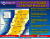
The entire state of Iowa is under a winter storm watch now. Don't see an entire state covered in one type of watch too often.
http://forecast.weather.gov/wwamap/png/US.png
Iowa is always in a good position for storms, I have seen it when the entire state is in a blizzard warning (dec 8, 2009). In my opinion, if you want winter storms Iowa is a great place to be.
-
 1
1
-
-
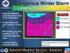
Something about this storm that makes me aggravated. If all this rain were anywhere east of here, this would be one of the most over covered hype and panic storms for flooding anywhere on the news. But it's Oklahoma, a foot of rain, probably historic river flooding and flooding in many other areas. Nothing to see here folks. Lol. I guess Oklahoma/Arkansas don't really generate the ratings like South Carolina does.
You are seeing tornado warnings, blizzard warnings, flood warnings and now an ice storm warning. You guys are going to have a tough night!
Ice Storm Warning
URGENT - WINTER WEATHER MESSAGE
NATIONAL WEATHER SERVICE NORMAN OK
431 PM CST SAT DEC 26 2015
OKZ015-016-021-022-033>036-270645-
/O.UPG.KOUN.WS.W.0003.151227T0000Z-151229T0000Z/
/O.NEW.KOUN.IS.W.0003.151227T0000Z-151229T0000Z/
DEWEY-CUSTER-BECKHAM-WASHITA-HARMON-GREER-KIOWA-JACKSON-
INCLUDING THE CITIES OF...TALOGA...WEATHERFORD...CLINTON...
ELK CITY...SAYRE...CORDELL...HOLLIS...MANGUM...HOBART...ALTUS
431 PM CST SAT DEC 26 2015
...ICE STORM WARNING IN EFFECT UNTIL 6 PM CST MONDAY...
THE NATIONAL WEATHER SERVICE IN NORMAN HAS ISSUED AN ICE STORM
WARNING...WHICH IS IN EFFECT UNTIL 6 PM CST MONDAY. THE WINTER
STORM WARNING IS NO LONGER IN EFFECT.
* TIMING...LATE TONIGHT THROUGH MONDAY MORNING.
* ICE ACCUMULATIONS...ONE QUARTER TO THREE QUARTERS OF AN INCH OF
ICE WILL BE POSSIBLE BY MONDAY MORNING. A FEW LOCATIONS COULD
RECEIVE NEARLY AN INCH OF ICE.
* IMPACTS...BRIDGES AND OVERPASSES MAY INITIALLY BECOME SLICK AND
HAZARDOUS LATE EARLY SUNDAY MORNING. ALL ROADWAY CONDITIONS WILL
THEN DETERIORATE BY LATE SUNDAY AS SNOW AND SLEET DEVELOP ACROSS
THE REGION. IN ADDITION...NUMEROUS POWER OUTAGES WILL BE LIKELY.
-
Those are impressive flakes for EL Paso--- agree wasn't supposed to be snowing like it is now down there until later tonight...
If you look at El Paso's forecast page it shows 41 degrees and light rain...
-
Mean while its snowing like crazy in El Paso at the sun bowl!!
-
1
-
-
If this in fact stays the course, Jim Flowers must be given some props. He called this a week ago!!
-
1
-
-
Gotta love the consensus between weather offices....just stay the course tonight EURO!!
-
I'll bet the farm on wsw being issued and not blizzard watch.....I'm patiently waiting on the update by Hastings!!
-
Des Moines Euro:
MON 06Z 28-DEC -3.9 -2.8 1028 65 12 0.00 566 544
MON 12Z 28-DEC -2.2 -4.1 1019 83 100 0.29 562 547
MON 18Z 28-DEC -1.1 -1.1 1005 88 99 0.57 555 551
TUE 00Z 29-DEC -0.1 -3.7 998 93 96 0.37 538 540
TUE 06Z 29-DEC -0.8 -2.5 999 94 84 0.07 544 545
TUE 12Z 29-DEC -3.9 -6.2 1009 89 61 0.01 549 542
Can you give me KOLU please? Thanks!
-
You gotta figure those watches extend north and east by tomorrow, models starting to get a better grasp on the track.
-
Here is OLU: (congrats!)
MON 06Z 28-DEC -10.3 -4.6 1030 69 7 0.00 564 541
MON 12Z 28-DEC -9.6 -6.3 1022 78 100 0.09 557 540
MON 18Z 28-DEC -7.8 -7.3 1012 89 100 0.51 551 542
TUE 00Z 29-DEC -7.9 -8.3 1007 88 92 0.39 544 539
TUE 06Z 29-DEC -7.7 -9.5 1010 86 91 0.04 546 538
TUE 12Z 29-DEC -11.0 -10.3 1016 84 41 0.02 549 536
TUE 18Z 29-DEC -9.2 -8.8 1020 82 8 0.00 551 535
Thank you! I'm not as good as reading these things as you guys are but I would say that is all snow and a lot of it!
-
in a minute or two, here is Lincoln which looks like sleet to snow
KOLU when you get a chance.
-
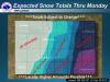
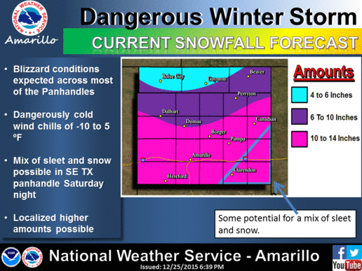
These are some insane totals being predicted for western Texas and the panhandle of Oklahoma.
-
I would really start feeling good if only the darn GFS would come more in line with the Euro. Then again, I have to coach in a holiday tournament and I don't want that getting pushed back or cancelled because of weather. Tough to figure out what to root for!
-
Reports of thunder, lighting and sleet tonight. I was on my way back home and seen a bolt of lightning! I must say, I wasn't expecting much of anything from this first wave but man did mother nature deliver!
URGENT - WINTER WEATHER MESSAGE
NATIONAL WEATHER SERVICE HASTINGS NE
802 PM CST FRI DEC 25 2015
...LIGHTNING ALONG WITH A MIXED BAG OF PRECIPITATION FOR SOME
AREAS INSIDE A NARROW BAND THIS EVENING. ALSO NEAR 3 INCHES OF
ACCUMULATING SNOWFALL FORECAST TONIGHT INTO SATURDAY FOR FAR
NORTHERN AREAS ALONG WITH A POSSIBLE WINTRY MIX OF
PRECIPITATION...
NEZ041-047>049-062>064-074>076-084-085-260600-
/O.CON.KGID.WW.Y.0012.000000T0000Z-151226T0600Z/
NANCE-HOWARD-MERRICK-POLK-HALL-HAMILTON-YORK-KEARNEY-ADAMS-CLAY-
FRANKLIN-WEBSTER-
INCLUDING THE CITIES OF...FULLERTON...GENOA...ST. PAUL...
CENTRAL CITY...STROMSBURG...OSCEOLA...SHELBY...POLK...
GRAND ISLAND...AURORA...YORK...MINDEN...HASTINGS...SUTTON...
HARVARD...CLAY CENTER...EDGAR...FAIRFIELD...FRANKLIN...CAMPBELL...
HILDRETH...RED CLOUD...BLUE HILL...BLADEN
802 PM CST FRI DEC 25 2015
...WINTER WEATHER ADVISORY REMAINS IN EFFECT UNTIL MIDNIGHT CST
TONIGHT...
A WINTER WEATHER ADVISORY FOR FREEZING RAIN...SLEET AND SNOW
REMAINS IN EFFECT UNTIL MIDNIGHT CST TONIGHT.
* TIMING...THROUGH MIDNIGHT.
* LOCATION...A NARROW BAND OF PRECIPITATION STRETCHING FROM NEAR
FRANKLIN TO HASTINGS TO CENTRAL CITY AND SILVER CREEK...AND
WITHIN ABOUT 20 MILES EITHER SIDE OF THIS LINE.
* PRECIPITATION TYPE...FREEZING RAIN...SLEET...AND SNOW. KEEP IN
MIND THERE IS A CHANCE OF LIGHTNING AS WELL.
* PRECIPITATION ACCUMULATION...LESS THAN A HALF INCH OF COMBINED
FREEZING RAIN...SLEET...AND SNOW THIS EVENING. MORE SNOW AND
FREEZING DRIZZLE IS POSSIBLE OVERNIGHT INTO SATURDAY MORNING.
* WINDS / VISIBILITIES...LOOK FOR REDUCED VISIBILITIES AT TIMES.
* IMPACTS...PLAN ON SLIPPERY ROAD CONDITIONS.
PRECAUTIONARY/PREPAREDNESS ACTIONS...
A WINTER WEATHER ADVISORY MEANS THAT PERIODS OF SNOW...SLEET...OR
FREEZING RAIN WILL CAUSE TRAVEL DIFFICULTIES. BE PREPARED FOR
SLIPPERY ROADS AND LIMITED VISIBILITIES...AND USE CAUTION WHILE
DRIVING. THE LATEST ROAD CONDITIONS FOR THE STATE YOU ARE CALLING
FROM CAN BE OBTAINED BY CALLING 5 1 1.
$
HEINLEIN -
Not only do I get a white Christmas and thanksgiving, I'm currently seein light snow! What a great couple days, now I'm hoping this next storm system is a share the wealth storm for a lot of us to enjoy! Merry Christmas everyone!
-
12z Euro is even farther NW and showing no snow for IA/WI/SE ME now...that precip is more than likely sleet/freezing rain in C IA/S&C WI...
I'm pretty sure that's 14+ right over my house!!! If anybody can give the digital read out for snow totals I would appreciate it!
-
.
It's been amazing how consistent the Euro has been, I mean that's like 3 days in a row with pretty much the same path. There was a little change from run to run, but nothing like the 350 mile change the GFS has been doing!! I'm liking it!
-
.
Straight thru central missouri, perfect!! This looks like the strongest run it has had yet!! 994 mb low, I like it, can't wait to see the snow totals.
-
Holy cow is the Euro loaded with moisture...just look at that comma shape to the precip coming straight out of the GOM...thats a thing of beauty if you love meteorology.
Looks good for us, doesn't look like there is much shifting to the south and east from last night.
-
Dodge City not jumping on one model over the other just yet.
-
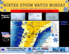
The old Texas blizzard......
Blizzard WatchURGENT - WINTER WEATHER MESSAGE
NATIONAL WEATHER SERVICE LUBBOCK TX
306 PM CST THU DEC 24 2015
...DANGEROUS WINTER STORM REMAINS ON TRACK FOR LATE WEEKEND...
A DEVELOPING STORM SYSTEM IN THE DESERT SOUTHWEST WILL PULL
ABUNDANT MOISTURE NORTH ACROSS WEST TEXAS THIS WEEKEND. MUCH
COLDER AIR WILL ARRIVE ON SATURDAY AND SET THE STAGE FOR A
PROLONGED WINTER STORM BEGINNING SATURDAY NIGHT BEFORE ENDING
LATE MONDAY MORNING. BLIZZARD CONDITIONS...HEAVY SNOW AND A
WINTRY MIX AT TIMES WILL LIKELY CREATE TREACHEROUS TRAVEL
CONDITIONS AND COULD SUSPEND TRAVEL ALTOGETHER.
TXZ021-022-027-028-033-034-039-040-251400-
/O.NEW.KLUB.BZ.A.0001.151227T0000Z-151228T1800Z/
PARMER-CASTRO-BAILEY-LAMB-COCHRAN-HOCKLEY-YOAKUM-TERRY-
INCLUDING THE CITIES OF...FRIONA...BOVINA...FARWELL...DIMMITT...
HART...MULESHOE...LITTLEFIELD...OLTON...MORTON...LEVELLAND...
DENVER CITY...PLAINS...BROWNFIELD
306 PM CST THU DEC 24 2015
...BLIZZARD WATCH IN EFFECT FROM SATURDAY EVENING THROUGH MONDAY
MORNING...
THE NATIONAL WEATHER SERVICE IN LUBBOCK HAS ISSUED A BLIZZARD
WATCH...WHICH IS IN EFFECT FROM SATURDAY EVENING THROUGH MONDAY
MORNING.
* WINDS AND VISIBILITY...NORTHERLY WINDS OF 30 TO 40 MPH WITH
FREQUENT GUSTS NEAR 55 MPH. VISIBILITIES FROM FALLING AND
BLOWING SNOW COULD FALL TO NEAR ZERO AT TIMES.
* SNOW ACCUMULATIONS...WIDESPREAD 6 TO 10 INCHES WITH HEAVIER
SWATHS POSSIBLE. SNOW DRIFTS UP TO 10 FEET ARE POSSIBLE.
* WIND CHILLS...THE COMBINATION OF STRONG NORTH WINDS AND BITTERLY
COLD TEMPERATURES WILL PRODUCE WIND CHILLS OF -5 DEGREES TO 10
DEGREES AT TIMES.
* IMPACTS...TRAVEL WILL BECOME EXTREMELY HAZARDOUS AND COULD
BECOME IMPOSSIBLE IN THESE CONDITIONS. -
HPC jumping on the southeast trend.....
-
2
-
-
not too likely at this point.
I'm thinking this thing turns into a non event for us in south-central nebraska. With the Euro going in the same direction as the other models, we are getting more and more closer to being on the edge of the deformation band. I agree, coming back to the northwest is looking more and more unlikely.
-
where you located gabel23?
20 miles south of Columbus.


12/26 - 12/29 Potential Wintry & Wet Winter Storm
in East of the Rockies
Posted
Holy cow it's bad in Texas, it's been a while since I've heard Jeff talk like that.....large violent tornadoes.