


gabel23
-
Posts
2306 -
Joined
-
Last visited
-
Days Won
5
Posts posted by gabel23
-
-
All time december record minimum set in Hastings this morning. If you use the record years as analogs, 1 out of the 3 years went on to produce above average snow for the season. 1939 went on to produce 40" of snow for Lincoln.
HASTINGS TIES ALL TIME RECORD WARM MINIMUM TEMPERATURE FOR THE
MONTH OF DECEMBER WHILE SHATTERING 93 YEAR OLD DAILY RECORD WARM
MINIMUM TEMPERATURE FOR DECEMBER 13TH...
THE LOW TEMPERATURE FOR DECEMBER 13TH AT THE HASTINGS MUNICIPAL
AIRPORT ONLY DROPPED TO 47 DEGREES. THIS BREAKS THE PREVIOUS
RECORD WARM MINIMUM TEMPERATURE OF 36 DEGREES SET BACK IN 1921...93
YEARS AGO. IN ADDITION...THIS RECORD IS TIED AS THE WARMEST MINIMUM
TEMPERATURE ON RECORD FOR THE ENTIRE MONTH OF DECEMBER. A WARM
MINIMUM OF 47 DEGREES FOR THE MONTH OF DECEMBER WAS ALSO RECORDED ON
DECEMBER 2 OF 1962 AND DECEMBER 10 OF 1939.
TEMPERATURE RECORDS AT HASTINGS ARE BASED ON NWS COOPERATIVE
OBSERVER REPORTS (HASTINGS 4N) BETWEEN THE YEARS OF 1907 AND JUNE
1996...WITH RECORDS SINCE JULY 1996 FROM THE AUTOMATED SENSOR AT
HASTINGS MUNICIPAL AIRPORT. -
Hopefully some of you in the Plains can manage to squeeze out some surprise snowfall outta this. I know that there are a few in C NE. Storm is definitely taking shape and the models are targeting the north/central part of NE.
I would seriously just need a shift of about 50 miles and I'm seeing 3-5". Don't think it will happen, hard to believe how warm it is for the middle of December.
-
At least for now those of us in Central Nebraska are excited. Still early to count on this, but fun to track this weekend.
These types of storms would be a close call for me. Situation is though if this storm tightens up it will more than likely end up further Northwest than what is showing. We shall see, I'm just excited to finally track a storm system.
-
Hoping to see something special like this sometime this season...the one system rolling through the LRC in early January has potential...
Only about 100 miles more to the northwest though.........
-
From Gary Lezak this morning and his winter forecast, you guys in the great lakes look in prime position. Us in the plains, well that's the same song and dance.......
-
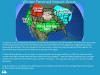
CPC changing its tune for December...I thought their previous forecast made on Nov 20th was in the right direction. This one seems way to warm now.
That looks like a Strong El-Nino forecast.........
-
Another record breaking day as far as temps go. Today marks the 7th day of temps below freezing and both hastings and grand island set record low max. Also to top the day off we had blowing snow to boot!!! Record lows for tonight as well as temps probably not reaching freezing for another day or two will mark one of the coldest streaks to occur in November around these parts. Hopefully we warm up a bit this weekend so I can get my lights up and then the snow and cold can stay all winter for all!!
-
 2
2
-
-
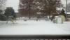
Ended up with 4" of snow. Way more than I was expecting, overall for being a weak system ended up over achieving for my area!
-
1
-
-
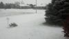
Nice pictures Gabel! I hope to awake to something like that tomorrow morning. Just wondering are those Oak trees in your neighbors yard? Otherwise those are really late trees to be holding leaves.
Forecast is still holding steady.
Thanks Geo! They are oak trees, that neighbor has two of them and my neighbor to the south, which would be to the left by the swing set, also has a big oak tree. Needless to say I still will have to find time to rake those leaves up when they all finally fall off!
-
Not much but hey its November and this is the second official snow of the year!
-
1
-
-
What a joke so far! Probably not even 1/2" and it's pretty much done. Didn't even come down hard enough to stick on the roads. Mainly pixie dust. We'll see what happens with this supposed 2nd wave. Not sure why any model is showing that much snow...
This really must have been hit and miss! For the most part our ground is completely covered, and this round two that will swing thru maybe will drop 1-2" additional. Must have really died out as it moved off to my east. Usually I receive the same amount as Omaha does.
-
Round 1 dropped 2" in my area. That sounds about right, York and Geneva received 2-2.5". Hoping round 2 drops another 2" and I will be real happy! Not a very organized storm but anytime we get snow in November I'll take it! Hope this is a sign of things to come this winter.
-
1
-
-
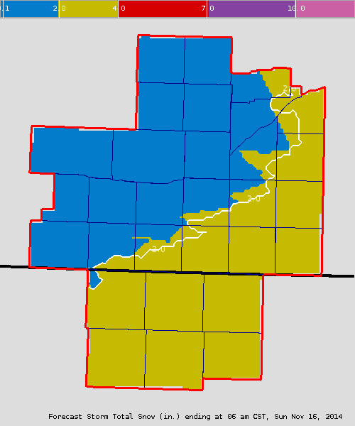
10/11 news rpm model showed 4-6" of snow for areas along and north of the platte river from Grand island to Columbus. I'll sneeze 100 dollar bills if that happens.
Looks like this model will win out!! 2-4" for most areas in eastern nebraska with 3-6" possible further north.
-
Haha^
4km NAM this evening. Showing a little more love for eastern NE.
http://www.tropicaltidbits.com/analysis/models/nam4km/2014111500/nam4km_asnow_ncus_21.png
Parallel GFS
http://www.tropicaltidbits.com/analysis/models/gfsp/2014111500/gfsp_asnow_eus_11.png
Their in-house model also showed a complete dominant northern wave. Snow going on in nw nebraska expands and moves through early tomorrow morning; I'm hoping for a surprise or just a solid 2-4" strip of snow through the state. Hastings NWS page looks like a jigsaw puzzle with the advisories!!!
-
10/11 news rpm model showed 4-6" of snow for areas along and north of the platte river from Grand island to Columbus. I'll sneeze 100 dollar bills if that happens.
-
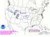
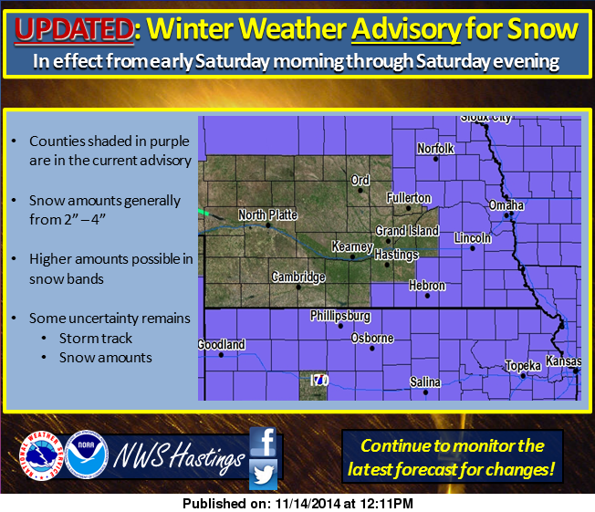
http://www.spc.noaa.gov/products/wwa/ Explain to me how in the hell Central Nebraska escapes without an advisory when literally every surrounding area has one. That just doesn't seem possible.
My grid is still calling for 1-3", the same amount as a county to my north, south and east and they are in the wwa. I would say everyone in the cwa will see 1-3" for the most part.
-
I'm in the 2-4" range off this updated snow graphic. I swear predicting snow amounts is like finding out how the universe was created!

-
What I don't buy is this map. Everyone is in a WWA except for me!! I'm the area where you have two counties not included! I agree, I have seen this a hundred times where this thing pops up and surprises a lot. Like I said yesterday, really anything I see will be awesome.

-
I'll take the GGEM please! Let's see what the king euro says, hopefully a nice phased system for all of us.
-
I really don't care if we receive a dusting, an inch or a couple of inches because it's November but the snow forecast is really funny. You have an area high lighted north of us and south of us with a slight chance of >4" of snow. Talk about bad luck, now when we get into the heart of winter and this happens then I'll start to be upset! Really anything we see is bonus in my book.
-
We have a lot of November left, but as I was saying yesterday this is very unusual cold for us in Nebraska. Hastings put this out this morning about the cold, we might have a shot at the coldest November ever! That is if the pattern doesn't flip to complete warmth towards thanksgiving, which personally I wouldn't mind having a warm thanksgiving and after that bring on the cold and snow! We have plenty of winter and I would like to have some warmth to get my x mas lights up! I start basketball practice on Monday and once that comes around I won't have time to do anything!
PUBLIC INFORMATION STATEMENT
NATIONAL WEATHER SERVICE HASTINGS NE
933 AM CST THU NOV 13 2014
...EXTENDED STRETCH OF BONE-CHILLING WINTER COLD UNUSUAL FOR
NOVEMBER...
TEMPERATURES ACROSS SOUTH CENTRAL NEBRASKA AND NORTH CENTRAL
KANSAS HAVE BEEN BELOW FREEZING FOR OVER TWO FULL DAYS. THE
TEMPERATURE AT GRAND ISLAND /THE PRIMARY LONG-TERM CLIMATE SITE IN
THE NWS HASTINGS AREA OF RESPONSIBILITY/ HAS BEEN BELOW FREEZING
SINCE 3 PM MONDAY.
THE LATEST NWS HASTINGS FORECAST CURRENTLY INDICATES TEMPERATURES
WILL REMAIN BELOW FREEZING ACROSS SOUTH CENTRAL NEBRASKA AND NORTH
CENTRAL KANSAS THROUGH NEXT TUESDAY. THIS IS AN EXTENDED STRETCH
OF SIGNIFICANTLY COLDER THAN NORMAL ARCTIC AIR. BY THE TIME
TEMPERATURES CLIMB ABOVE FREEZING...CURRENTLY PROJECTED TO OCCUR
NEXT WEDNESDAY THE 19TH...THE REGION WILL HAVE EXPERIENCED 8 FULL
DAYS OF SUB-FREEZING TEMPERATURES.
WHILE SUB-FREEZING HIGH TEMPERATURES ARE FAIRLY COMMON IN NOVEMBER
...THEY TYPICALLY ONLY OCCUR FOR TWO OR THREE DAYS AT A TIME.
USING GRAND ISLAND AS A PROXY FOR THE REGION...INFORMATION BELOW
COMPARES THIS CURRENT COLD BLAST TO SIMILAR EVENTS IN THE PAST...
THE LAST TIME TEMPERATURES DROPPED BELOW FREEZING IN NOVEMBER...AND
REMAINED THERE FOR 8 DAYS OR MORE...WAS IN 1985. THE HIGH
TEMPERATURE WAS 17 DEGREES ON THE 19TH...AND THE TEMPERATURE DID
NOT CLIMB ABOVE FREEZING UNTIL DECEMBER 4TH. THAT WAS A PERIOD OF
16 DAYS.
THE LAST COMPARABLE COLD STRETCH OCCURRED IN NOVEMBER 2000...FROM
THE 6TH TO THE 23RD. WHILE SUB-FREEZING HIGH TEMPERATURES WERE
OBSERVED ON MANY OF THESE DAYS...THE LONGEST STRING OF CONSECUTIVE
DAYS WAS ONLY FIVE DAYS ALONG...FROM THE 10TH TO THE 14TH. WHILE
STILL SIGNIFICANTLY COLDER THAN NORMAL...THERE WERE SEVERAL DAYS
BETWEEN THE 6TH AND 23RD IN WHICH THE TEMPERATURE CLIMBED IN THE
MIDDLE AND UPPER 30S.-
1
-
-
Today is day 2 of what looks like will be a 7-9 day stretch of temps not getting above freezing. In fact, we are looking at consecutive days of temps in the low 20's for highs and lows in the single digits. Hastings has been talking about this pattern and say this is the first time we have seen an air mass this cold in over 14 years. This is comparable to November 2000, although that was the third coldest November in Grand Island history. I think we can all agree if this winter turns out anything like the winter of 2000-2001 we would all love that! This cold snap was also comparable to November 1996. Was a very interesting write up Hastings put out yesterday.
-
That was a nice band of snow we had last night and with the temps below freezing all day the snow stuck to pavement and all. officially I would call it a dusting but to me in spots it looks like an inch. Either way our first official snowfall fell in November and I'm happy with that.
-
Seeing a really intense snow band coming through. Wind gusting to 45 mph. Will be short lived but good to see snow blowing around. Almost looks like a mini blizzard. Temperature 23 with wind chill in the single digits. Great January night in November.
Looks like the models picked up on this and maybe underestimated its intensity. Must be nice to finally see snow fall with the high winds and chilly temps. Hopefully it covers your grass!
That snow band is knocking on my door step and should be here within the next 30 minutes. I can't wait, we should see our first measurable snow of the season, granted it won't be much! Tom, I don't think the band will be persistent enough nor be able to stay on the ground with all the blowing to cover the grass! One thing is for sure I'm glad I was able to get my garden all cleaned up yesterday when the high topped out at 63!!
-
1
-


Christmas Eve Potential Major Winter Storm
in East of the Rockies
Posted
So much time to go with this thing, I wouldn't be surprised to see the trough 300 miles back west or further east. Will be fun to watch.