


Clinton
-
Posts
6542 -
Joined
-
Last visited
-
Days Won
28
Posts posted by Clinton
-
-
10 hours ago, Andie said:
It looks like 2 more days in low 80’s the a week in mid- to high 70’s.
Still no rain in site.
Anyone care to weigh in on that?Looks like ya have some rain coming mid week along with a risk of severe weather.
-
 1
1
-
 1
1
-
-
More record heat in western MO today, it's currently 79 at my place.
St Joseph current temp 81 record was 80 (1983) -Kirksville current temp 78 record was 70 (1955) -Sedalia current temp 80 record was 70 (2021) -Olathe current temp 77 record was 69 (2021) - P-Hill current temp 78 record was 73 (2008)
Kansas City just hit 80 degrees! It's the 5th earliest 80 degree day in KC's 136-year period of record.-
 3
3
-
 1
1
-
-
Warm and very windy in conditions here today, slight chance of rain tomorrow and a better one later in the week. I hope we get it because the drought conditions are beginning to intensify again.
-
4
-
-
Here's the February rundown for KC.
FollowHere's the February 2024 climate rundown: -Feb 2024 was 10.5 degrees above normal and the 3rd warmest on the 136-year record for KC. -Precip was 0.15" which was 1.33" below normal and the 5th driest on record. -Snow came in at 1.3" which was 4.6" below normal (35th least) -
Warm weekend ahead and hopefully I can get some rain soon as things have dried back out again.

-
2
-
-
Some crazy stuff from yesterday.
FollowAt Kansas City, the daily max temp was 73°. The daily low (recorded at 11:59 pm) was 19°. This daily temp range of 54° is tied for 4th largest on record. The other dates at the top? Nov 11, 1911 (65°) Jan 15, 1953 (57°) Nov 21, 1898 (56°) Mar 2, 1904 (54°) Dec 14, 2008 (54°)St. Joseph recorded a max temp of 78° just before 1 pm yesterday (2/27). This broke the previous daily max temp record of 76° set in 1976. At 11:59 pm, it was 20°. This daily temp range (MaxT - MinT) of 58° is the largest on record (since 3/1/1908). That's a strong cold front!-
2
-
-
Thunder, lighting and snowing falling with a temp of 32. This is a definitely a memorable weather day, I literally experienced all 4 seasons in about 12 hours.
-
3
-
 1
1
-
-
I have a thunderstorm moving through right now with a temperature of 39. 4 hours ago it was 80!
-
3
-
 1
1
-
-
I hit a record high of 80 today. Cold front just rolled through, temps are dropping. Snow possible in about 6 hrs or so lol.
-
5
-
1
-
-
Yesterday as expected set record highs.
Kansas City reached 77° today, breaking the long-standing record of 76° set all the way back in 1896. Kansas City is likely to finish the month as the 3rd warmest February on record, behind Feb 1930 and Feb 1954.Meanwhile, St. Joseph reached 80° today, shattering the record of 73° set in 1988. It is only the 2nd time in recorded history that St. Joseph reached 80° or above, with 83° on 2/24/1930 being the other (period of record began 3/1/1908).More record highs today and I could reach 80 degrees this afternoon before cold and some snow move in tonight. Weather whiplash!
-
5
-
1
-
-
Tuesday has a chance to be a historic weather day here, record highs will likely be set in my area with temps in the low 80s to snow falling before midnight.
Kansas City and surrounding areas are about to have a very dramatic weather change. It will likely go from near 80° Tuesday afternoon to 1" of snow possible by midnight.
-
1
-
1
-
-
Windows open in the house and detailing my truck today. Currently 69 with bright sunshine.
-
3
-
1
-
-
Early May like weather to start the week which will likely set new record highs Monday and Tuesday and some big storms possible to my east.

-
3
-
-
Dry and mild for me the next several days and will make a run at record highs on Monday and Tuesday.
-
1
-
1
-
-
Here is where this winter ranks so far and it's depressing especially for the northern half of the country.


2023 warmest ever on record

-
1
-
 1
1
-
-
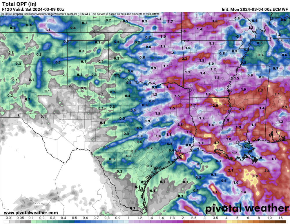
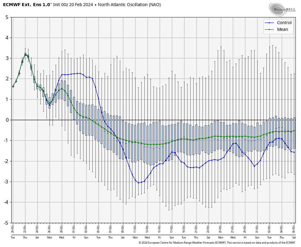
There are more signs of below average temps showing up for weeks 2 and 3 of March and snow for the north and western members of the sub. The JMA has been consistently taking the MJO into phase 3 but with no support from the other models until now the GEFS, CFSv2, and CMET have joined in and the Euro is slowly adjusting that way.
.png)
The EPS starting to take on a snowy look for some in the extended and this mornings GFS has quite the storm around the 9th which would line up with the LRC as a very wet storm should move across the sub in that time frame.

5th -9th

GEFS this morning. Winter probably has 1 last gasp

-
3
-
 1
1
-
-
2 hours ago, tStacsh said:
Looks like March is coming in like late April.
My temps next week would be normal for late April. 78 in the forecast.
-
1
-
2
-
-
Day 6 slight risk in February. I'm not sure whether to be excited or sad.


-
1
-
1
-
-
Looks like somethings brewing for the northern members to close out the month.
0z Euro

6z GEFS

-
1
-
-
I'm not saying it's right by any means but the Euro weeklies suggest winter isn't over.
For entertainment purposes only but the point is it's cold and wet through March.


The JMA and GEFS showing a phase 3 in March which is cold.
-
3
-
 1
1
-
-
This February for western MO will go down as the warmest or 2nd warmest in history, currently we are +10.6 above average. Look at these temps for the next 7 days! What happens in days 8,9,10 won't look like this.
-
2
-
-
Down right chilly this morning as temps dropped well below expectations. It's currently 11 with some light snow cover from yesterday morning and the forecasted low for mby was 20. It was not a bad storm for some there are some nice snowfall totals to my east.

-
6
-
 2
2
-
-
I got an inch of snow this morning, it was very nice scenic snow. The February sun angle is quickly going to work on it.
-
5
-
-
A little Winter today with some slushy snow. Latest models trends indicating an inch or 2 of accumulation today. Also this Winter hasn't been a total loss, the drought is over. I wouldn't have thought it was possible to break an extreme drought during the dry season.


-
4
-

March 2024 Observations and Discussion
in East of the Rockies
Posted
Cooler weather for my area today with temps in the upper 50s. Warm and windy conditions over the past month have really dries things out. Hopefully the 1-2 inches of rain the models show for Thursday and Friday pan out.