

Requiem
-
Posts
6891 -
Joined
-
Last visited
-
Days Won
3
Posts posted by Requiem
-
-
Gorgeous undercutting low. I reiterate my thought that hopefully that earlier low tempers itself in future runs so we're not toeing the line of too far west.
-
 2
2
-
 1
1
-
-
Fwiw I don't expect that low to be as strong as it is this run
-
2
-
1
-
-
11 minutes ago, Gradient Keeper said:
00z GFS Day 6-10, 8-14 Analog Composite. ... Check this out.
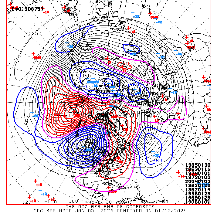

1996!
-
2
-
-
Our euro, who art on tropical tidbits, hallowed be thy name...
-
 1
1
-
 1
1
-
-
GEM is over. I am currently buying Canadian flags to burn would anyone want in on this investment opportunity
-
2
-
 1
1
-
 2
2
-
1
-
-
This is a run for the ages, wow
-
5
-
-
2 minutes ago, MR.SNOWMIZER said:
Yep, I remember you lost your shitt about some wind storm.
Not in February 2019, no. January, maybe?
-
Pretty sure even the mighty February 2019 saw this level of waffling within 200-150 hours from models (including the EURO). We'll be fine for now.
-
5
-
-
Hyperamplified GEM run-- hopefully the EURO doesn't show this solution but it's at least "nice" to see a different failmode than what we've been seeing on bad runs.
-
Models will waffle, models will change. It just is what it is. We have consistency in the ensembles, which is always nice. That being said, the ICON is just a bad model for this region and I don't think I've ever seen it be right for even run of the mill events within 96 hours, let alone such a tenuous setup with huge meteorological ramifications. Any "it's over" posts should unequivocally not be because of the ICON.
-
4
-
-
4 minutes ago, Frontal Snowsquall said:
Gonna be a fun night of model riding!

Stressful actually
-
2
-
 1
1
-
 1
1
-
-
To my knowledge the strongest period of gorge winds in recent history for the metro area was sometime in late January to early February 1996. Curious about that setup, actually, which I've never really looked into.
-
1
-
-
I still don't think any storm was as surreal to track in recent memory as this past February. Models had all but pulled back totals into a virtual non event for most areas-- until one single model suite came out with the crazy totals that we ended up actually receiving in the metro area. It was like a switch had flipped. At least with January 2017 and February 2014 there was some definite confidence we would get *some* meaningful snow.
-
2
-
-
Absolutely nasty setup for the WV and metro area as far as ice goes
-
1
-
-
Day 5 now looking more like the EURO evolution-- doesn't split that lobe of energy into a well defined surface low off the OR coast like the previous couple runs.
-
4
-
1
-
-
This run is just so... stagnant? Some brief easterlies, but it's just cold-- no overrunning, no undercutting, nothing. Hopefully next few models don't show a solution like this
-
2
-
-
GEM seems fine up to hour 192 fwiw
-
4
-
-
I don't adore that westward dig but I feel as though things end up trending too far east than they do too far west (hoping I don't jinx this)
-
2
-
-
5 minutes ago, Deweydog said:
Interesting that this may be our fifth occurrence in the last four years where we have decent agreement within a “believable” range for what would be considered a top tier event (1/20, 2/21, 12/21, 12/22). Not to mention the run ups to last January and February’s events.
Been quite run for model riders.
The two days of model watching before last February's event was absolutely incredible. Those insanely convective solutions just started coming out of nowhere after disappearing for a time.
-
2
-
-
Ensembles blips and waffling seem well within expectation for 8-10 days out? What matters is pattern evolution, which seems consistent at this current moment. On the other hand this is forum custom

-
5
-
-
Seasonably chilly temps this run
-
 1
1
-
-
Nice to see a little consistency but I still remember January 2020... at least this looks like a better setup.
-
We're so back
-
1
-
3
-
 3
3
-
-
Easterlies set up past day 10-- some great potential for an overrunning event
-
3
-
January 2024 Weather in the PNW (Part I)
in West of the Rockies
Posted
Would be lovely to see a January 1969 dream scenario with those lows just funneling moisture into south-central Oregon.... really would be something to tell future generations