

Requiem
-
Posts
6891 -
Joined
-
Last visited
-
Days Won
3
Posts posted by Requiem
-
-
Slightly colder run but little change.
-
 1
1
-
-
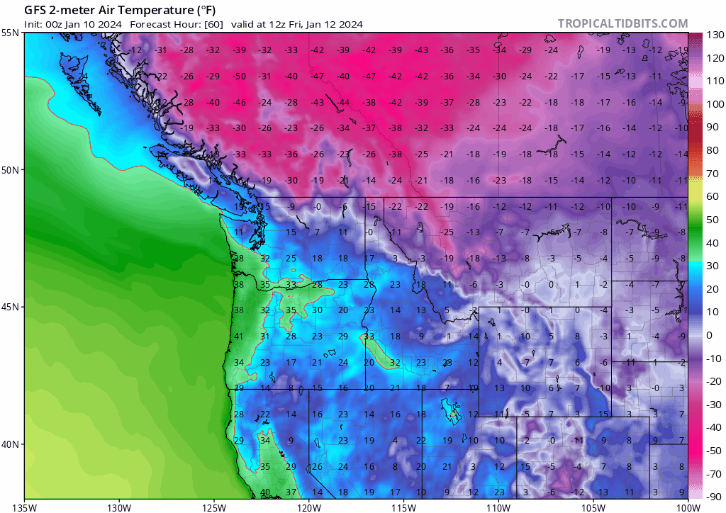
Rare to see this from the GFS so close to an Arctic event.
-
9
-
-
Cold air slightly quicker this run
-
4
-
-
Fwiw (likely not much), the FV3 came in way south of its 12z but in accordance with today's model suite.
-
1
-
-
If I am to fathom a guess GFS comes in slightly more south and then pretty much holds
-
If I had to guess I would say around Pacific City for general low position
-
1
-
-
1 minute ago, Doinko said:
ICON looks like a snow to zr to snow storm for PDX
Wouldn't pay attention to the ICON's precip type right now, at face value that's all snow
-
4
-
 1
1
-
-
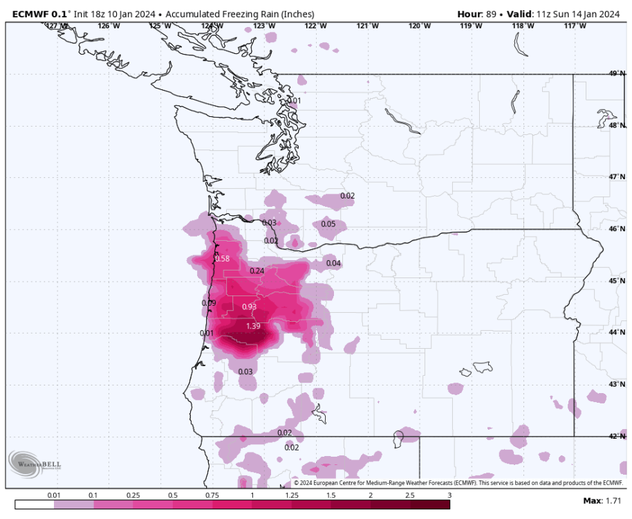
One great thing is seeing that second low, rather than slam into California, hit southern Oregon instead on recent models (including the 18z Euro). Brings a lot more snow potential into the mix.
-
4
-
1
-
-
ICON looking more like the EURO and NAM. Very nice to see. Really reminding me of February 2014
-
6
-
1
-
-
2 minutes ago, Perturbed Member said:
00z vs 18z


Oh-- I was talkin' about the 18z Euro vs. the 12z, the 00z NAM is definitely wetter
-
3
-
-
Just now, Doinko said:
A lot snowier though
Fwiw the 18z had more moisture overall (and more further north)
-
3
-
-
2 minutes ago, MR.SNOWMIZER said:
Every run of multiple models are different on every run. How can we be locked?
Low landfall location on most models but the GFS haven't been too drastically different in the past few runs
-
I think we may have locked on-- NAM looks fairly similar if not slightly more north
-
1
-
 1
1
-
-
Just now, Perturbed Member said:
00z NAM looks a bit north?
Interestingly it's actually faster with the progression of cold air
-
7
-
 1
1
-
-
3 minutes ago, TT-SEA said:
Way south seems more unlikely now with the 18Z ECMWF/EPS shifting north again.
I think the snow zone will be Portland-Salem-- and the ice/wintry mix zone Salem south to Eugene. Especially with the Euro seemingly deciding on a general zone of where the landfall area will be at this current venture.
-
3
-
-
Just now, TigerWoodsLibido said:

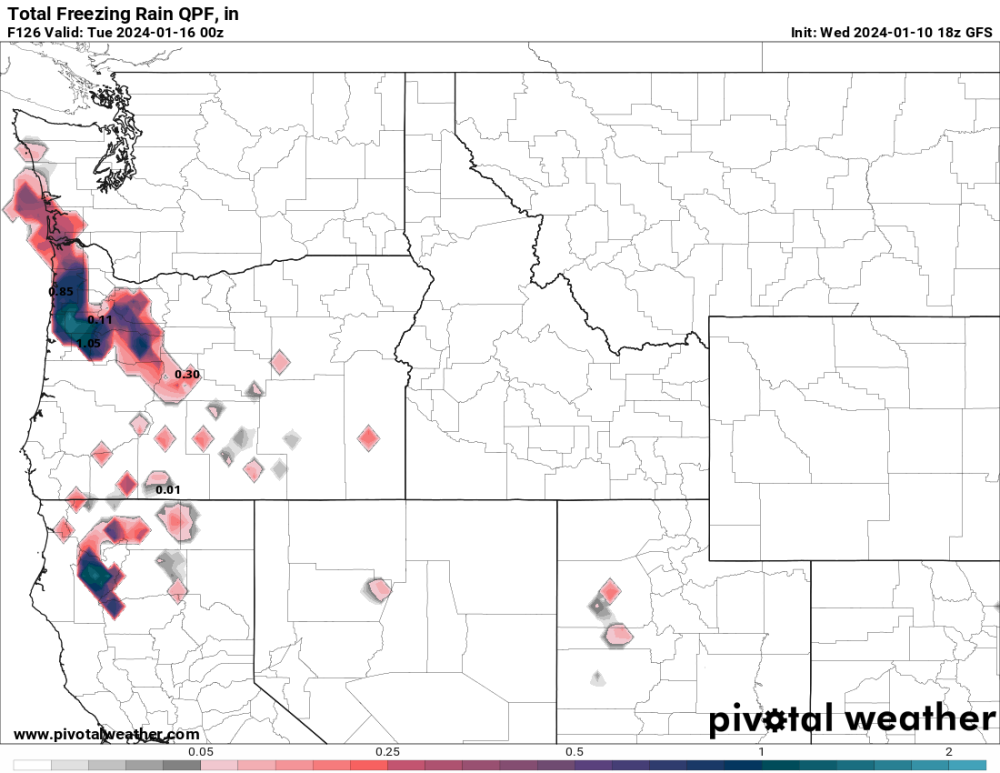
Would be fairly damaging-- I'm not taking these numbers at face value but if we do this would be worse than that big crippling ice storm back in December 2016
-
 1
1
-
-
2 minutes ago, Christensen87 said:
I told ya'll this is why I can never fully get onboard unless the CFS shows something as well

Quite frankly, it never really did...
CFS was not onboard for cold either...
-
2
-
-
1 minute ago, Deweydog said:
I don’t think the low position is all that important. This is more about the lift/interaction associated with the low level air mass.
I know analogs only go so far as to predictive accuracy, but would you say there are any semi-recent events that this upcoming one could emulate?
-
Ow... by any indication this'll be further south next run
-
1 minute ago, TT-SEA said:
For Seattle... 7.6 inches on 00Z run... 5.2 inches on 12Z run... and now 3.1 inches on 18Z run.
Its not collapsing. Its slowly caving.
I expect most models to either cave to the Euro or the Euro to slightly shift north. The shift of some models this suite was interesting-- that being said I still think the sweet spot for the weekend is the central valley.
-
2
-
-
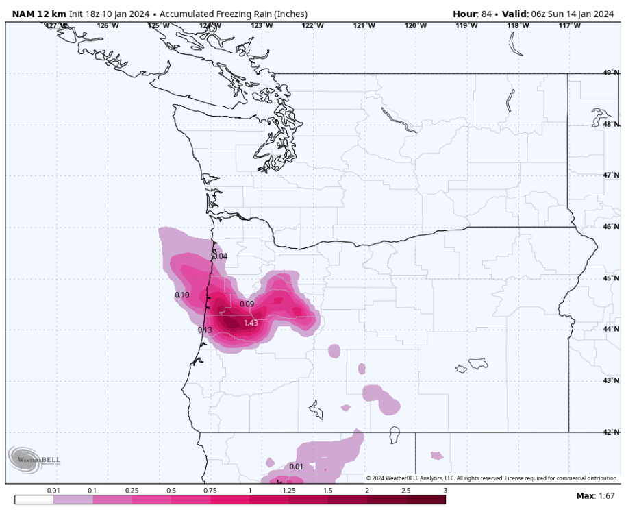
Shades of February 2014... kinda
-
5
-
 1
1
-
-
24 minutes ago, TigerWoodsLibido said:
We are so fuckked...lol
Gonna stock up on groceries...
-
1
-
-
I am on board for a you geen winter storm
-
2
-
-
1 minute ago, Mid Valley Duck said:
The 6z was extremely juicy so it’s probably the NAM just being the NAM. Honestly think you, me and TWL could end up the big winners. Which a day or two ago I would have thought it was impossible
Not sure if Eugene will be able to avoid a nasty ice storm instead, but your neck of the woods is absolutely in a good spot right now (and you guys deserve it more than anyone in PNW lowlands atp)
-
1
-


January 2024 Weather in the PNW (Part II)
in West of the Rockies
Posted
The Tanna Tuva model (which takes its data from the Ulaanbaatar weather observatory) just released new experimental data and there are big changes. Huge north trends, huge south trends. Definitely warner, but also way more frigid.