


KTPmidMO
-
Posts
96 -
Joined
-
Last visited
Everything posted by KTPmidMO
-
The way models are trending im about to be missed to the north with the main snow field..
-
NAM was absolutely pathetic and ugly here for me in Central MO, to be honest I hope that's not what other models start trending to. I would have been pretty much in the bullseye here all week to only get the rug pulled out from under me the day or 2 before.
-
Did we even get a Winter storm watch/warning last year? I dont believe I did.
-
Oh shoot I didnt see that threat. Thanks for letting me know!
-
Has anyone paid attention to the storm for next Thursday/Friday? GFS has it as an even more powerful storm than this one and has shown that for several runs now. I has it at 970 mb as it passes by STL. Crazy! Gary Lezak said that storm may very well be bigger and stronger than even this storm.
-
D**n the NAM is WAAAAYYYY north compared to other models. Yet, another wrench thrown into the fire! Has the Nam been very accurate lately?
-
Anyone have the 18z Euro control?
-
I saw a report that the Us Air Force Hurricane Hunters will be flying inside the storm today taking samples. If thats the case, that means we will have "true" data which will be loaded into the weather models. By 00z tonight the data suite is likely to be much more accurate than all previous guidance runs.
-
A lot of members with nice hits for here in Central MO. I'll take Member 20 all day! lol
-
Clinton, what is your opinion on this storm here in MO? I was looking an NOAA 7 day forecast for Jeff City and they have the whole event forecast as either rain or rain/snow mix. No mention whatsoever of accumulating snow in the 7 day forecast. Yet, if you read forecast discussion, they mention accumulating snow will happen somewhere in central Missouri. Am I missing something? Are we not gonna be able to get the cold air like models are predicting?
-
I agree with that! GFS way south but GEFS north. Models don't have a handle on this thing yet I don't believe.
-
Where did you get this run from? I like that run though, and the storm isn't even done in Missouri yet.
-
Which has been the most consistent model at this range this year?
-
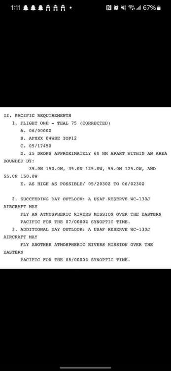
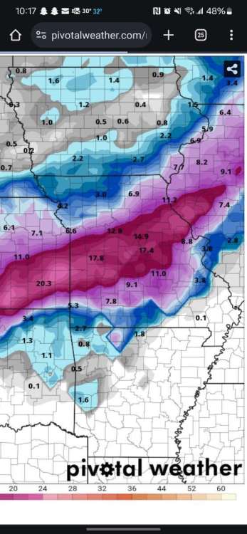
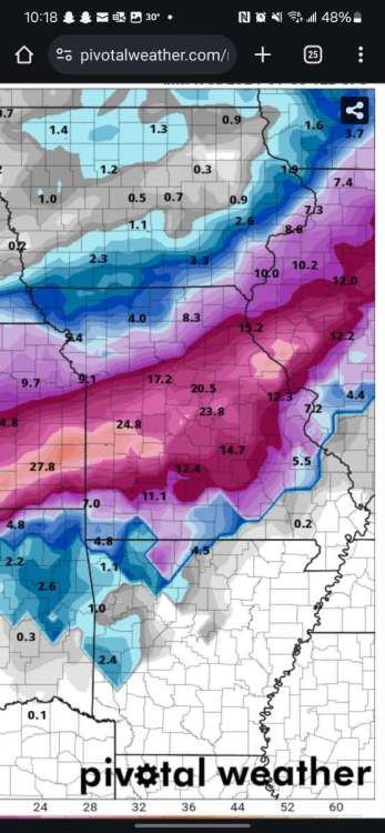
Nice run through Missouri again with the 12z GFS. I'd love for this to pan out. First screenshot is kuchera ratio, second is 10:1. What kind of ratios are we expecting with this event here in Missouri, less than 10:1??
-
Can you post the most recent AI models please?
-
Heck yeah! That's what I like to see! What an improvement here for MO.
-
Can you post it?
-
Boy that run sucked for snow here in central Missouri compared to 00z run. Is this gonna be another storm where we just cant get the cold?
-
12z Euro run coming in colder so far.
-
January 2024 Observations and Discussion
KTPmidMO replied to Minny_Weather's topic in East of the Rockies
Do we want to start a separate thread for these storms? -
January 2024 Observations and Discussion
KTPmidMO replied to Minny_Weather's topic in East of the Rockies
Can someone post all the ensemble members for the 12z GFS run? Or is there somewhere that I can view those for free? -
January 2024 Observations and Discussion
KTPmidMO replied to Minny_Weather's topic in East of the Rockies
Anyone have the 18z GFS ensembles? -
January 2024 Observations and Discussion
KTPmidMO replied to Minny_Weather's topic in East of the Rockies
LETS GO! Come on we need a big storm to pan out, we are overdue here in Central Mo. -
January 2024 Observations and Discussion
KTPmidMO replied to Minny_Weather's topic in East of the Rockies
I would take half that in a heartbeat! Yes please I hope this track pans out! Lol -
I would gladly take this, yes please!


