


Beltrami Island
-
Posts
368 -
Joined
-
Last visited
Posts posted by Beltrami Island
-
-
3 minutes ago, OmahaSnowFan said:
so now it's every other cycle of a 63.5 day cycle that mirrors each other? Huh?
Then wouldn't that actually make it a 127 day cycle, especially since we're referencing a storm from 10/2 (which wasn't 64 days ago)?
The key is any time you see the word cycle or LRC referenced, you just ignore it. You will be much happier.
Please LRC followers/believers can we have just one concrete example from past weather that a LRC forecast has verified?
-
 1
1
-
 1
1
-
-
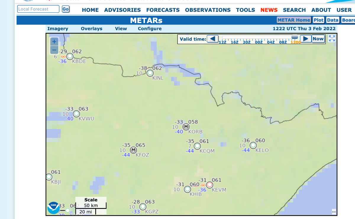
9 hours ago, Grizzcoat said:
Pushing -40 at the "ICE BOX" of the lower 48- KINL's record is -40 in 1982 for this date.

You looked an hour too soon. KINL got down to -42. KBDE got down to -34. Wind was noticeably absent all night, which of course helped the radiational cooling to reach those lows. Highs close to 0 now for a 40 degree temp rise in about 7 hours.
-
1
-
-
2 hours ago, FAR_Weather said:
I become MSP_Weather on January 28. Mark the date.
So major snow and blizzard for ND and northern MN, rain for MSP within 2 weeks...alright then.
-
 1
1
-
-
3 minutes ago, Madtown said:
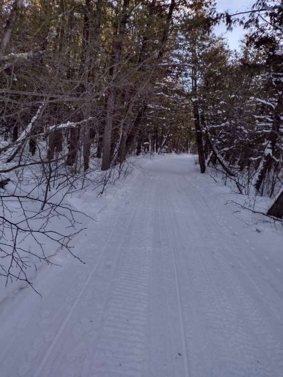
Looks like a swing and a miss up here on the clipper tomorrow unless the GFS beats them all. Trails are beat up pretty bad from the insane traffic this past weekend.
My nws point forecast says 3-5" tomorrow. That seems to be all in on the loner gfs. I'd be happy with a couple inches.
-
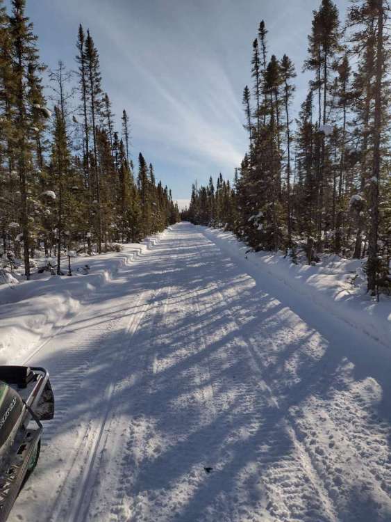
Finally had a chance to get out on the sled. Conditions are pretty good. Nothing spectacular snow depth wise, but heck of a lot better than any time last year.

-
9
-
-
Just now, FAR_Weather said:
I mean, good for Sioux City who has been shafted the past 4 years. But I'd still like to see some fresh powder in Duluth, even if it's only a couple inches.
Duluth and myself look SOL on this one. I can't really complain about my snow depth, its about average for the date, but I seem to be on the edge or miss completely on any decent snow systems.
Eastern ND looks like its getting the flip side of average from last year when they hardly got any snow.
-
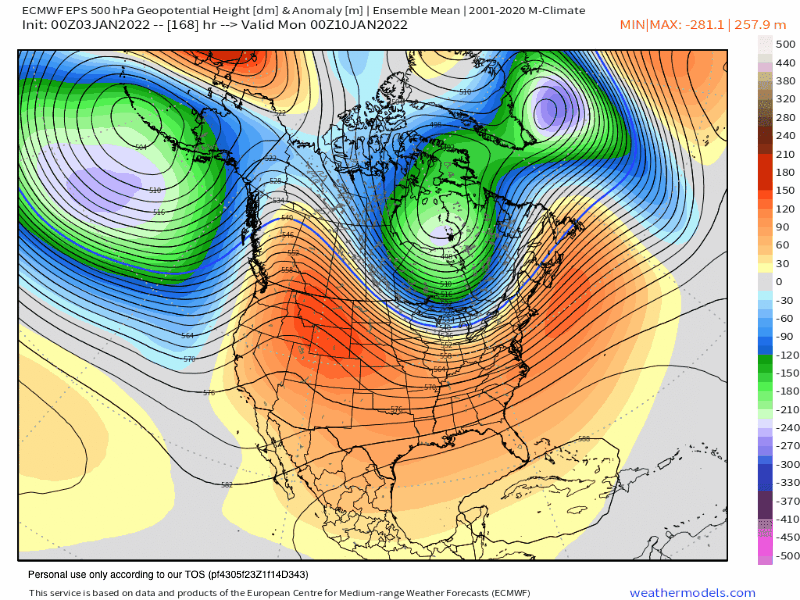
Looking at western Canada, these two graphics seem diametrically opposed. Is it just to be concluded that the CFS is junk, or that the strength of the ridge in the west is being way overdone by the Euro?

-
1
-
-
-33f for me this morning. At least it's sunny as can be and relatively calm.
Reminds me of 2013-14 new years and how cold that winter was, 3 straight days of -20 highs that week. That was a week before the first instance of "Polar Vortex" in the mainstream media.
-
1
-
 1
1
-
 1
1
-
 1
1
-
-
10 minutes ago, FAR_Weather said:
Rumor has it that when the temperature drops, it gets colder.
That's a John Madden line if I ever heard one....
-
2
-
-
22.7" 72 hour snowfall total for Jamestown, ND. Pretty incredible considering its in the middle of the ND prairie and averages about 40" annually.
-
3
-
 1
1
-
-
53 minutes ago, Tom said:
This same area is forecast to receive up to 90” of snow through Sat! Just incredible…for those who have been praying for Snow, I’d say they have been answered…share some of that over here…
The Sierras are well known for getting 10 foot dumps in a weeks time. They can also sit under a ridge for weeks at a time between those snow dumps. The back to back to back..... snow dumps happening out there right now is unique though.
-
1
-
2
-
-
I love how you call the CPC long range "forecasts" guesses. Guess is a much more accurate word than forecast. Give them a moderate to strong el nino conditions then you can call it a forecast, anything else is a guess.
-
3
-
-
7 hours ago, Thunder98 said:
North Dakota is looking cold in the short term.
Cold? Seasonal is the word I'd use. Pretty average December temps there.
-
This thing is cutting so fast NW it has no chance to get any gulf moisture to the NW side of the low until it gets to far northern ontario to produce snow.
Gonna be windy as heck for all though.
-
I'd guess I got 4-6" total, leaning more toward the 4" side. Strong SE, E, and NE winds during the bulk of the snowfall and strong N/NW winds with cold front passage make getting an actual measurement difficult in my location.
-
2
-
-
2 hours ago, FAR_Weather said:
It's pretty hectic out here. Textbook ground blizzard.
Yup, looks like Fargo. Once the actual snowfall stops and the snow is just blowing across the ground, you start to wonder where in fact did this snow hitting your face first reach ground level? At times you would swear the answer feels like northern Saskatchewan.
-
3
-
1
-
-
To be fair to resorts. Anyone can drive up and access a lake from a public access with marginal ice conditions.
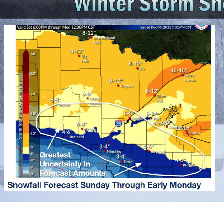
Back to snow, first difinitive map with amounts I've seen from nws
-
3
-
-
Yes, Baudette. Saw somebody out on Red in a portable driving down the Wednesday morning before Thanksgiving. Those are the the types you hope get a search and rescue bill when the ice shifts and leaves them on an island needing rescue.
I haven't kept track of ice conditions. 45° and 40mph winds couldn't have helped anything a couple days ago.
-
2
-
-
1 hour ago, Madtown said:
Let's lock this in Grizz
100% agree lock that in!
1 hour ago, Grizzcoat said:Madtown- how are the lakes up there as far as ice cover/thickness?? I would imagine this snow is not going to help matters- (ie. slush/bad ice do to insulating of the snow
Ice anglers are like farmers, always finding something to complain about weather wise. I here it from all around my area.
-
2 hours ago, FAR_Weather said:
Now, I AM discouraged by the overall drier trend. An earlier digging trough would help immensely with that.
All of the medium range models seem to have a bias of overdoing the pacific moisture remnant of storms tracking due west to east over the northern rockies and through the dakotas.
-
1
-
-
6 minutes ago, FAR_Weather said:
Come onnn... One county southhhhh...
This is like the euro vs world. Euro has been consistent hitting the full northern 1/3 of mn and into Canada slightly. Every other model I look at has the border in the northern fringe possibly shut out completely.
-
1
-
-
Well I have the latest Euro giving me 0.7" of precip all snow Sat-Sun, so I got that going for me, which is nice....
I have seen similar circumstances where I end up with nothing, hoping for something interesting. It's been since mid January 2020 for a real winter storm in northern minnesota. Last months Vetran's day slopfest doesn't really count as a winter storm in my mind.

-
4
-
-
That Aleutian ridge looks beautiful to me. I know some here would like it a bit further east. Sitting in the NW of this sub, this is the pattern I would draw up from scratch for my optimum winter weather pattern. Just 12 days out, what could go wrong?

-
1
-
1
-
-
13 hours ago, FAR_Weather said:
Amazingly got some lake effect here tonight from Devils Lake. A dusting, but still cool as you don't associate the Dakotas with LES. 28°F.
That's awesome. I find early season LES off of larger inland lakes to be one of the coolest weather peculiarities I have experienced. The general public doesn't have any clue what is going on... The setup has to be absolutely perfect though. Most significant I have experienced is about 6" in one day in Baudette off of Lake of the Woods. The cold air that makes it possible quickly shuts it down as ice starts to form.
-
2
-
1
-


February 2022 Observations and Discussions
in East of the Rockies
Posted
Nice clipper indeed with snow falling since morning. A few hours yet to go. Probably going to be more like 2-4 inches versus the inflated 6" kuchera numbers.
Trails here were already in mint condition really. Other than one stretch of trail near resorts there really isn't the traffic here to beat up trails to badly once there is a base. Areas near @Madtown really need the fresh snow to hold up to the traffic.