


Meatyorologist
-
Posts
9121 -
Joined
-
Last visited
-
Days Won
13
Posts posted by Meatyorologist
-
-

I don't mean to be overly dramatic, but the Euro is seriously undermodeling the southerly low here. I have an alarm for 5:30 in case the weather world is blowing up. Or maybe the energy will get reconsolidated into the main low. Or maybe the low really is being undermodeled, but the tack will only be significant for maybe a 5mph or so overachievement. I guess we'll have to wait and see.
-
 2
2
-
 1
1
-
-
1 minute ago, hawkstwelve said:
Here's another one I know nothing about, but it's windy so I'm sharing it!
It has a mild mixing bias, so I'd knock off 15-20%. Still some decent gusts around 45mph or so.
-
1
-
-
Just now, hawkstwelve said:
Not sure the background on this model but it shows a gustier solution so I like it!
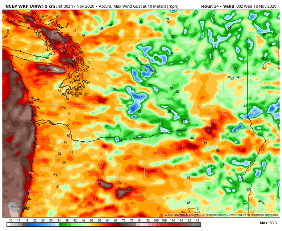
It's so-and-so from my amateur perspective. Do NOT look at its cousin, the ARW2. It has a significant mixing bias and will regularly deliver 70mph clearcutters from random convective events and run-of-the-mill windstorms.
-
1
-
-
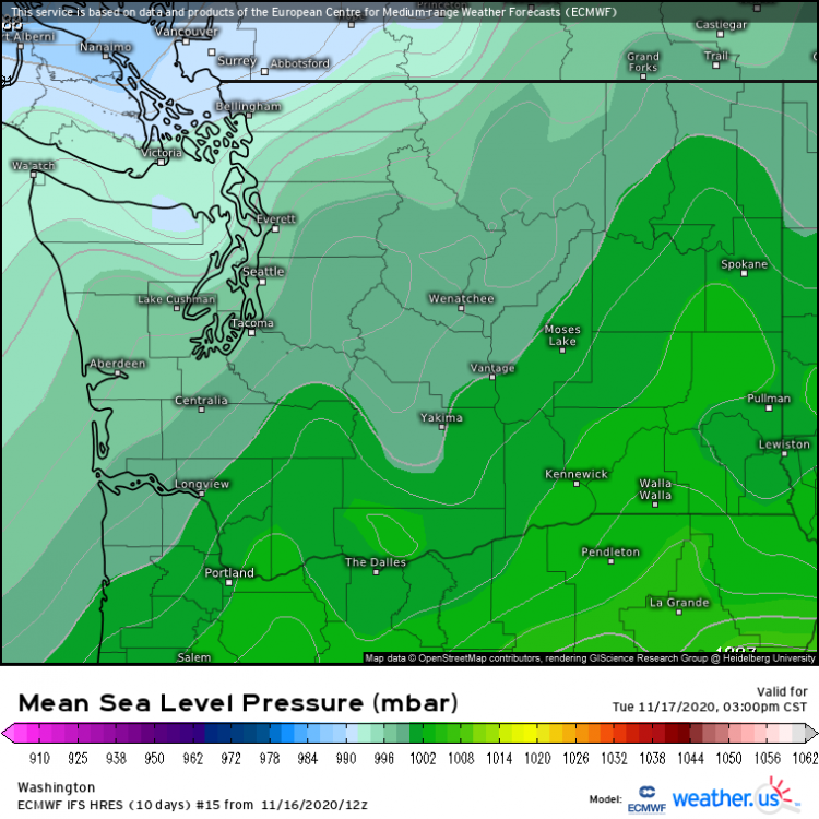
1 minute ago, DJ Droppin said:
As of 10:20 PM the southern low is down to about 982mb.
NWS Portland had the low getting down to 985mb by early tomorrow morning. Could be a sign of a windy bust.
-
1
-
-
Just now, iFred said:
Hey folks!
As we have what might be our first big event of the season, I want to ask everyone their input to an idea and a favor.
First, what are people's thoughts to kicking off a separate topic to track this storm? Not that we would kick people out of this thread, but having a thread where people can nowcast, hit repeatedly with maps and pictures, and something that would be easier to reference in the future.
Secondly, please get the word out about the forum. I would like to see more people participate, new members on, and some old timers come out of hiding. We don't make money off of this, and I'll never ask for a donation drive, put up ads, or sell your data. This site is up for the love of weather and and I think with our recent upgrades, it'd be nice to get some new folks on here.
Anyway, nice to see that low deepen.With our relatively small forum size, I'm quite alright with the consolidation of all our weather talk on here. Honestly, during peak hours we're only at 1-3 posts/minute at worst. Though if we did make another forum you wouldn't hear me complaining.
I'll try to get some weather folx on here. Maybe Anthony would find this place interesting.
-
2
-
-
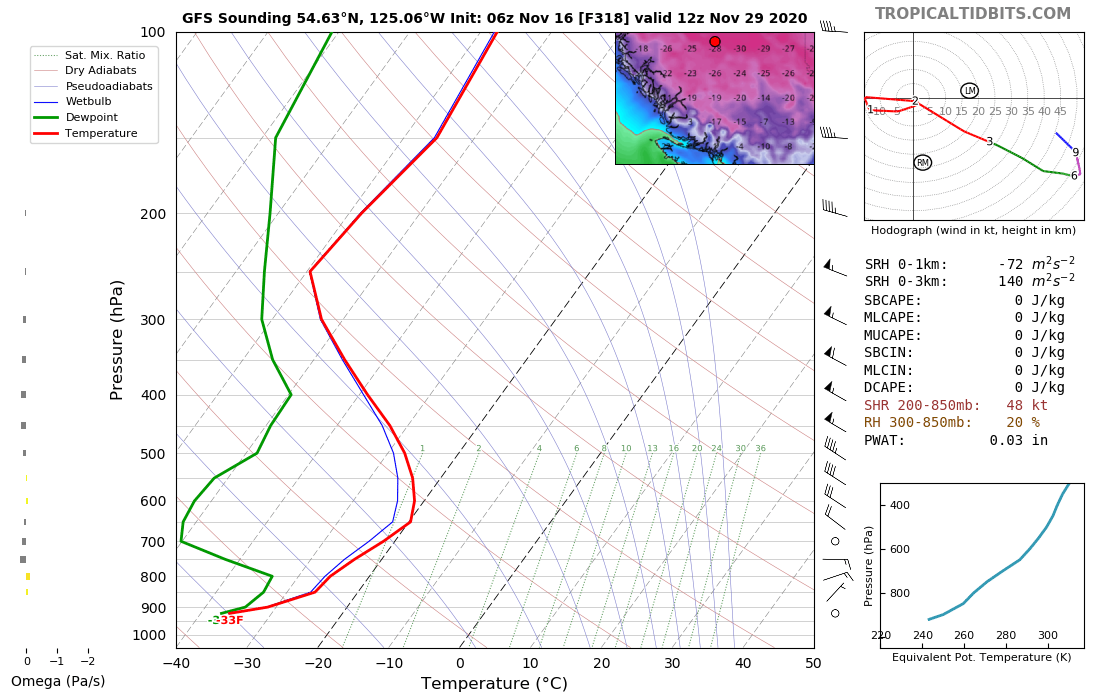
Just now, Jbolin said:
I would expect that southern low to continue deepening as we head into the evening hours, I would say between 4-10mb between now and roughly 4 am.
I also have seen in the last few frames of the WV a noticeable "jog" to the E/NE and also a bit over 100 miles closer to the coastline (possibly making a N/Central Van Isle), along with a stout 170kt jet in place and I think we see regionwide impacts starting around mid/late morning.
That's a stark development. Will need close watching. 925mb jet is about as good as it gets around here, just need to mix that to the surface
-
1
-
 1
1
-
1
-
-
25 minutes ago, Timmy said:
When does the low elevation snow take place?
 Very gross 36F mixing event
-
1
-
 1
1
-
-
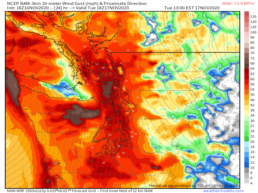
Might have to make it out to Discovery Park if the NAM keeps showing this. Immediate bursts of strong wind are so exciting!
-
2
-
-
Just now, iFred said:
what are the surface feature for this member compared to the OP
Powerful secondary low rushing northward. Top-tier pressure falls. But this has a one-in-fifty shot of actually occuring, so it won't happen.....

-
1
-
1
-
-
Just now, seattleweatherguy said:
This one wont happen, almost no chance right?
Virtually no chance.
-
1
-
-
Euro member #15 FTW
-
 Greenland Ice Shelf cold. Too bad it slides east.
-
 Wizard is going to love this... Nice PV lobe knocking on the door in the fantasy range. First significantly arctic system to appear in the long range since earlier this month.
-
 1
1
-
-
Only 25% of 00z Euro members get above 55mph gusts throughout the region, same as 12z suite, but the ones that do go crazy. A few 70+'s in there. Still disagreement on timing, though this time within the 12pm Tue. and 12am. Weds timeframe instead of the wild 30 hour spread in timing 24 hours ago. As to be expected with a cyclone that has finally begun development.
-
4 minutes ago, Weather1011 said:
I'm up in Vancouver so ill take it.
If you have time off, it might be worth a ferry ride to southern Vancouver Island near Ucluelet or Port Renfrew. Victoria will be significantly wind shadowed, so not there..
-
1
-
-

Not bad. A little stronger in the Puget Sound region due to random mesoscale features that won't be ironed out until the few hours preceding it. Overall a very similar run. Still high uncertainty with this system.
-
1
-
1
-
-
3 minutes ago, seattleweatherguy said:
south would affect the puget sound more or less?
Remains to be seen (meant to reply to this one)
-
This will actually likely be a less windy run from its 12z counterpart despite the much closer main low placement. This is because it consolidates its energy more into a more closed low form, rather than the weird height falls to the SE of the low center that would spawn the quick wind burst. Low is closer, but still miles offshore.
If the Euro ensemble members pick up on a closer low but continue the extraneous height falls, there could be a higher % of windy members. Or maybe they consolidate around the main. We'll find out soon enough.
-
Euro a little more south so far...
-
1
-
-
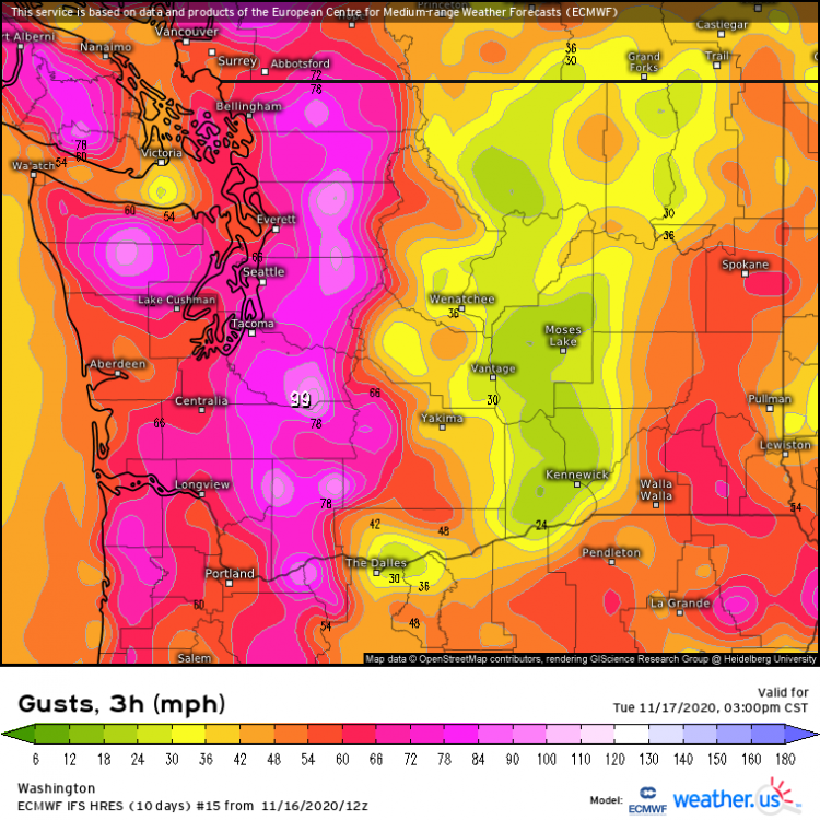
Just now, SouthHillFrosty said:
Post them pls?
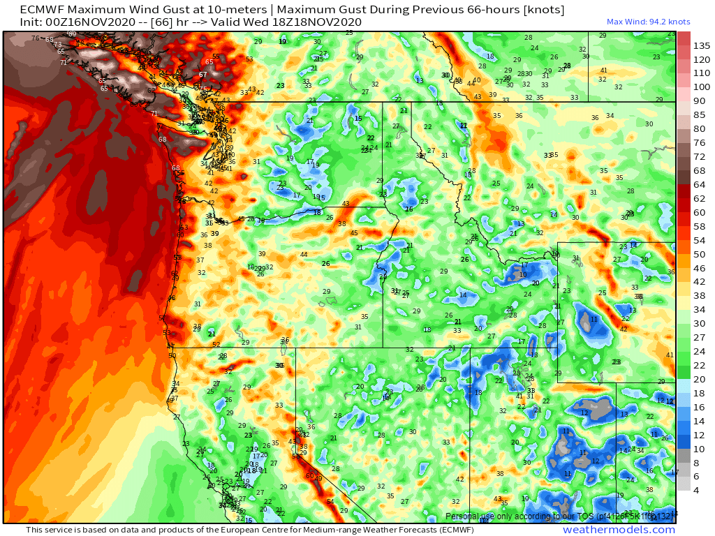
https://weather.us/model-charts/euro/washington/gusts-3h-mph/20201116-0600z.html
-
1
-
1
-
-
12z EPS members were windier, but it's only really a 40% chance whether we get to 50mph.
-
1
-
-
Only 10% of the GFS ensemble members even crack 50mph, with one peaking at around 60mph. Huge inconsistencies in timing, much like the Euro ensemble. Very low-res, too.
-
I counted up the ensemble member of the Euro suite, and found that 25% of them give Seattle a major blow (55mph+), with only 10% higher than 65mph. None skipped out on a windstorm entirely (>30mph gusts), save for one which peaked at 28mph.
Very interestingly, I found that the timing on this system varies wildly, anywhere from 6:00am Tuesday to 6:00am Wednesday. Most were around 3-9:00pm on Tuesday.
-
1 minute ago, TacomaWaWx said:
Yeah I remember that one pretty well. Winds picked up real fast peaked for about an hour and then they died down rapidly on the backside. I think it was totally calm at 12:30am that night then by 1am it was cranking hard here and from 2-215am the wind really calmed down quickly.
Yeah, that was a really cool one. It was dead calm here, even with 50mph gusts being reported in Federal Way.
Then, out of nowhere, the air kicked up a bit with a 20mph or so gust. Then a 30mph. Then a 40mph. And within 15 mins, branches were flying in the air.


November 2020 Weather Observations for the PNW
in West of the Rockies
Posted
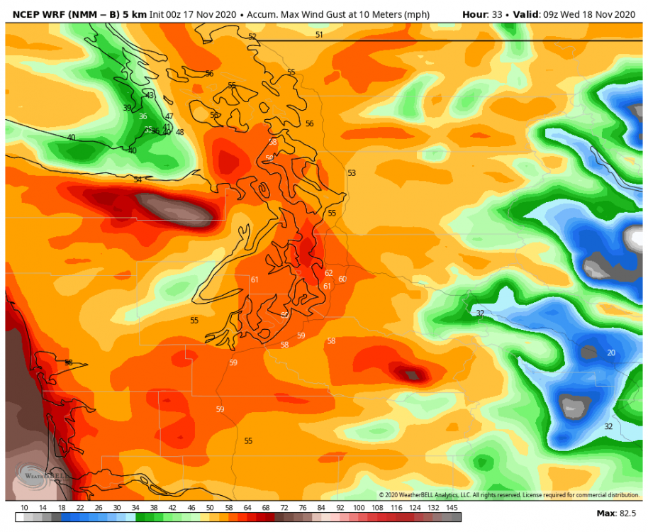
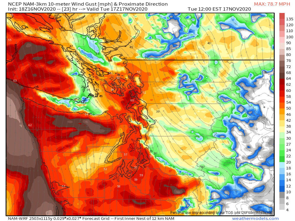
Even the NAM, which at least predicted the existence of the southerly low, is ~10mb short. Keep in mind this model brought 62mph gusts to West Seattle.